
Driving Through Time - The Digital Blue Ridge Parkway

Search Results:
-
Land Acquisition Maps Section 2-A
1938
-
 NP 21 before planting
1938
-
Land Acquisition Maps Section 2-C
1938
-
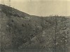
 Shoulder construction, High Piney Ridge in background
1938
-
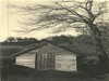
L.F. Caudill
1938
-
 Rock cut at Devil's Garden
1938
-
 Cumberland Park Pump House
January 5, 1938
-
 Mahogany Rock Parking Overlook after grading
January 24, 1938
-
 Cumberland Knob Slope flattening at entrance
January 24, 1938
-
 Sheep Hill Brand Lodge Site and proposed water storage
March 1938
Items in Query
Results: 80
Refine Your Search
Types (3)
Photographs (76) Maps (3) Drawings, Plans, and Projections (1)Locations (25)
Doughton Park (10) Section 2A (9) Milepost 239 (8) Cumberland Knob (5) Milepost 230 (5) Milepost 241 (5) Devil's Garden (4) Milepost 224 (4) Section 2C (4) Bluff Park (3) Bluffs (3) Milepost 238 (3) R.L. Martin Tract (3) Milepost 219 (2) Milepost 240 (2) Bluff Park Maintenance Area (1) Hare Mill Pond (1) Mahogany Rock (1) Milepost 218 (1) Milepost 223 (1) Milepost 228 (1) Milepost 229 (1) Milepost 231 (1) Milepost 247 (1) Section 2B (1)Sections (3)
2C (40) 2A (32) 2B (8)Counties (1)
Alleghany (80)

