
Driving Through Time - The Digital Blue Ridge Parkway

Search Results:
-
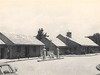 Bluffs Coffee Shop & Service Station
20th Century
-
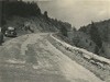
 Pky. at Air Bellows Gap
20th Century
-
 Parking overlook
1930s
-
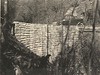
 Guard wall
1930s
-
 Opposite Woodruff's
1930s
-
 Farmland and road
1930s
-
 #10 Bridge over Little Glade Creek
1930s
-
 Before grading. 1:1 cut gullying badly; too steep to grass; flatten and round for grass
July 25, 1935
-
 General view of construction rough grading
November 26, 1935
-
 Bluff Park Culvert Grassy Gap Road
January 5, 1936
Items in Query
Results: 194
Refine Your Search
Types (1)
Photographs (194)Locations (41)
Section 2C (32) Section 2A (29) Doughton Park (27) Cumberland Knob (13) Bluff Park Maintenance Area (5) Bluffs Coffee Shop (5) Milepost 217 (5) Milepost 229 (5) Milepost 237 (5) Air Bellows Gap (4) Mahogany Rock (4) Milepost 221 (4) Bluff Park (3) Devil's Garden (3) Fox Hunters Paradise (3) Hare Mill Pond (3) Little Glade Pond (3) Meadow Fork Valley (3) Milepost 218 (3) Milepost 228 (3) Milepost 240 (3) Alligator Back (2) Bluffs (2) Junction of 2A/2B (2) Milepost 224 (2) Milepost 225 (2) Milepost 227 (2) Milepost 238 (2) Milepost 241 (2) Milepost 242 (2) Brinegar Cabin (1) Bull Head Mountain (1) Intersection of Blue Ridge Parkway at North Carolina State Route 18 (near Ennice, N.C.) (1) Milepost 223 (1) Milepost 226 (1) Milepost 234 (1) Milepost 239 (1) Milepost 243 (1) Milepost 247 (1) Roaring Gap (1) Wildcat Rocks Overlook (1)Sections (3)
2C (98) 2A (80) 2B (14)Counties (1)
Alleghany (194)

