
Driving Through Time - The Digital Blue Ridge Parkway

Search Results:
-
Location Plan for Overpass at North Carolina St. H'way #26
1935
-
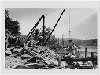 Stone Masons
1935
-
Regional Sketch Map
1935
-
 Special headwall 10' x 7' R.C. box
May 25, 1935
-
 Special Headwall, 10' x 7' R.C. Box
May 25, 1935
-
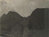 Bull Head Mountain and Deep Gap panorama
May 31, 1935
-
 Devils Garden Showing Steep Rocky Slopes
May 31, 1935
-
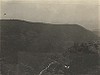
 Panorama of Green Mountain
May 31, 1935
-
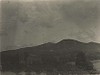 Bull Head Mountain taken from Rte#26
May 31, 1935
-
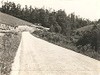 Overpass near Mulberry Gap (from NC #18 on west)
June 20, 1935
Items in Query
Results: 41
Refine Your Search
Types (2)
Photographs (39) Maps (2)Locations (16)
Milepost 221 (6) Milepost 226 (5) Milepost 218 (4) Section 2A (4) Junction of 2A/2B (3) Milepost 227 (3) Bull Head Mountain (2) Intersection of Blue Ridge Parkway and North Carolina State Route 18 (near Laurel Springs, N.C.) (2) Milepost 217 (2) Milepost 228 (2) Milepost 229 (2) Section 2B (2) Cumberland Knob (1) Devil's Garden (1) Roaring Gap (1) Roaring Gap Hotel (1)Sections (3)
2A (30) 2B (6) 2C (2)Counties (1)
Alleghany (41)

