
Driving Through Time - The Digital Blue Ridge Parkway

Search Results:
-
 Typical Sheet Property Map
20th Century
-
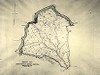
Regional Sketch Map
1935
-
Location Plan for Overpass at North Carolina St. H'way #26
1935
-
Road and Parking Area
1937
-
Land Acquisition Maps Section 2-B
1937
-
L.F. Caudill
1938
-
Land Acquisition Maps Section 2-A
1938
-
Land Acquisition Maps Section 2-C
1938
-
Fire Hazard Map
1939
-
Cabin Group
1940
Items in Query
Results: 29
Refine Your Search
Types (2)
Maps (27) Photographs (2)Locations (7)
Bluff Park (11) Cumberland Knob (6) Section 2B (5) Section 2A (3) Section 2C (2) Bluff Park Maintenance Area (1) Bluffs (1)Sections (3)
2C (15) 2A (9) 2B (5)Counties (1)
Alleghany (29)

