
Driving Through Time - The Digital Blue Ridge Parkway

Search Results:
-
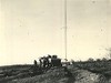 Radio Tower and House
1940
-
 Azalea Bloom
1940
-
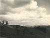
 Pedestrian Overlook at Fox Hunters Paradise
1940
-
 Picnic Area #3 After Ice Storm
1940
-
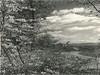
 Bluff Park looking east
1940
-
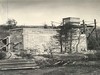 Incinerator Construction progress
1940s
-
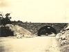 Grade Separation Structure Over US 21 Looking Northwest
1940
-
 Site of comfort station Picnic area #1
1940
-
 View looking south on parkway
1940
-
 763-B Comfort station & trail shelter picnic area #3, Bluff Park, sec. 2-C
1940
Items in Query
Results: 827
Refine Your Search
Types (4)
Photographs (810) Maps (13) Newspaper Articles (3) Drawings, Plans, and Projections (1)Locations (53)
Doughton Park (209) Brinegar Cabin (98) Mahogany Rock (69) Cumberland Knob (51) Milepost 238 (32) Bluff Park (28) Section 2A (24) Bluffs (23) Section 2C (21) Milepost 237 (20) Bluffs Coffee Shop (15) Wildcat Rocks Overlook (15) Bluff Park Maintenance Area (14) Fox Hunters Paradise (14) Stone Mountain (14) Milepost 217 (13) Milepost 221 (13) Milepost 241 (13) Milepost 229 (11) Air Bellows Gap (10) Bluffs Lodge (10) Milepost 234 (10) Milepost 242 (8) Section 2B (8) Caudill Cabin (7) Little Glade Pond (7) Meadow Fork Valley (7) Milepost 231 (7) Alligator Back (4) Milepost 220 (4) Milepost 228 (4) Milepost 239 (4) Roaring Gap (4) Devil's Garden (3) Milepost 224 (3) Milepost 232 (3) Milepost 243 (3) Bull Head Mountain (2) Hare Mill Pond (2) Intersection of Blue Ridge Parkway at North Carolina State Route 18 (near Ennice, N.C.) (2) Milepost 227 (2) Milepost 230 (2) Milepost 240 (2) Milepost 244 (2) Milepost 247 (2) Deep Gap (1) Fishers Peak (1) Intersection of Blue Ridge Parkway and North Carolina State Route 18 (near Laurel Springs, N.C.) (1) Junction of 2A/2B (1) Milepost 218 (1) Milepost 219 (1) Milepost 225 (1) NC State Line (1)Sections (3)
2C (538) 2A (151) 2B (137)Counties (1)
Alleghany (827)

