
Driving Through Time - The Digital Blue Ridge Parkway

Search Results:
-
 Mitchell Falls Mt. Mitchell
20th Century
-
 Mitchell Falls
20th Century
-
 Mitchell Falls
20th Century
-
 Shufford Log Barn, Bldg. #596
1930s
-
 Tunnel
1930s
-
Detail Map of Location from the Blue Ridge Parkway to Mt. Mitchell, under County Project 595, Buncombe, Yancey Counties
1940
-
 "Old Man of the Mountain" near the Falls of Dan, and only 1 mile north of the Pinnacles
Early 1940s
-
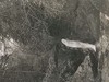
 Slide near Crabtree Meadows
November 1951
-
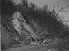
 Slide near Crabtree Meadows
November 1951
-
Land Acquisition Maps Section 2-N
Items in Query
Results: 11
Refine Your Search
Types (2)
Photographs (8) Maps (3)Locations (5)
Mount Mitchell (4) Section 2M (3) Milepost 339 (2) Milepost 354 (1) Section 2N (1)Sections (2)
2N (6) 2M (5)Counties (1)
Yancey (11)

