
Driving Through Time - The Digital Blue Ridge Parkway

Search Results:
-
 NC-80 overpass at Buck Creek Gap
1950s
-
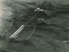
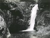 Mitchell Falls
1950s
-
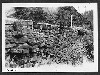 Rock Wall, Project 2M2
February 27, 1951
-
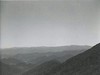 Bald Mountains & Walnuts
October 1951
-
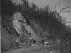 Slide near Crabtree Meadows
November 1951
-
 Slide near Crabtree Meadows
November 1951
-
 T. erectum - maroon, unknown trillium (yellow)
May 14, 1952
-
Parkway Land Use Map Section 2-M
1953
-
 Dr. Elisha Mitchell's Grave, Mt. Mitchell
March 12, 1957
-
 Dr. Elisha Mitchell's Grave, Mt. Mitchell
March 12, 1957
Items in Query
Results: 73
Refine Your Search
Types (2)
Photographs (72) Maps (1)Locations (13)
Mount Mitchell (24) Milepost 345 (9) Buck Creek Gap (6) Section 2N (6) Milepost 346 (5) Milepost 344 (4) Milepost 355 (4) Section 2M (4) Licklog Ridge Parking Overlook (3) Milepost 339 (3) Bald Mountain (2) Milepost 350 (2) Yancey County (1)Sections (2)
2N (42) 2M (31)Counties (1)
Yancey (73)

