
Driving Through Time - The Digital Blue Ridge Parkway

Search Results:
-
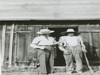 Bob Hawks (Gunsmith in Fancy Gap vicinity) and Chief Ranger E.M. Dale
1900s
-
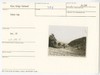
 Fancy Gap Overlook Site
20th Century
-
 Fancy Gap
20th Century
-
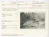
 Fishers Peak Park. Proposed lake area from dam. Horse Knob background
April 23, 1937
-
 Overpass site US Route 52
May 3, 1937
-
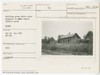
 Wood tract Pierce Collins estate
April 21, 1938
-
 Panoramic View from Parkway near Fisher's Peak
May 1939
-
 Puckett Cabin House recommended retained as is.
July 25, 1939
-
 Building group which state proposed to remove. Puckett group. RAZED
July 25, 1939
-
 Office ERA
1940
Items in Query
Results: 29
Refine Your Search
Types (1)
Photographs (29)Locations (11)
Milepost 199 (8) Section 1V (5) Fancy Gap Overpass (4) Section 1W (3) Granite Quarry Overlook (2) Puckett Cabin Parking Area (2) Milepost 191 (1) Milepost 201 (1) Milepost 202 (1) Milepost 206 (1) Milepost 210 (1)Sections (3)
1V (21) 1W (5) 1U (3)Counties (1)
Carroll (29)

