
Driving Through Time - The Digital Blue Ridge Parkway

Search Results:
-
 Sign - National Forests
20th Century
-
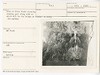
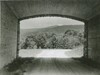
 View from proposed line of Parkway looking across valley from near Highco Mtn.
September 1936
-
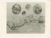
 Area at Otter Creek crossing showing pool
September 17, 1936
-
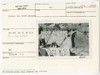
 Photograph of Master Plan - Buena Vista to Laurel Fork
November 6, 1936
-
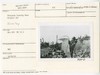
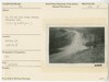 Va. 605 and Blue Ridge Parkway
November 18, 1944
-
 Site Data for Structure (Underpass)
November 18, 1944
-
 Structure Site and Access Location
November 18, 1944
-
 Project 1L3, North Abutment
October 20, 1949
-
 Overpass looking West. Project 1L2
October 20, 1949
-
 Irish Gap Bridge
1952
Items in Query
Results: 14
Refine Your Search
Types (1)
Photographs (14)Locations (7)
Irish Gap Overpass (6) Otter Creek Bridge No. 8 (2) Section 1G (2) Bluff Mountain Overlook (1) Intersection of Blue Ridge Parkway at U.S. Route 60 (1) Milepost 60 (1) Milepost 61 (1)Sections (3)
1G (7) 1E (6) 1F (1)Counties (1)
Amherst (14)

