
Driving Through Time - The Digital Blue Ridge Parkway

Search Results:
-
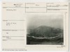 Harkening Hill
May 28, 1942
-
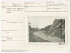
 Bedford power line crossing
June 24, 1942
-
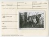
 Typical ditch condition in thru cuts -- looking south
February 27, 1945
-
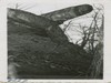
 Dirt slide in ditch, looking south
February 27, 1945
-
 Cross rocks looking north
November 15, 1946
-
 Cross rocks looking N.W.
November 15, 1946
-
 Cross rocks, looking northeast
November 15, 1946
-
 Cross rocks, looking northeast
November 15, 1946
-
 Cross rocks, looking south
November 15, 1946
-
 Road to Sharp Top before construction. Slope flattening
November 15, 1946
Items in Query
Results: 459
Refine Your Search
Types (2)
Photographs (458) Drawings, Plans, and Projections (1)Locations (35)
Peaks of Otter (99) Sharp Top Mountain (Va.) (72) Peaks of Otter Lodge (Va.) (41) Peaks of Otter Bus Station and Camp Store (38) Peaks of Otter Visitor Center (30) Milepost 86 (26) Peaks of Otter Campground (21) Virginia State Route 43 at Little Stony Creek (17) Peaks of Otter Picnic Area (14) Section 1K (12) Sharp Top Overlook (9) Milepost 87 (8) Milepost 90 (7) Headforemost Mountain Overlook (6) Milepost 98 (6) Peaks of Otter Service Station (6) Flat Top Mountain (Va.) (5) Intersection of Blue Ridge Parkway at Virginia State Route 43 (4) Milepost 99 (4) Pine Tree Overlook (4) Sharp Top Mountain Bus Shelter (4) Bobblets Gap Overlook (3) Goose Creek Valley Overlook (3) Milepost 93 (3) Milepost 97 (3) Big Spring (Va.) (2) Milepost 95 (2) Powell Gap (2) Section 1J (2) Bearwallow Gap (1) Milepost 65 (1) Milepost 71 (1) Milepost 79 (1) Milepost 94 (1) Montvale Overlook (1)Sections (4)
1K (439) 1J (14) 1L (4) 1H (2)Counties (1)
Bedford (459)

