
Driving Through Time - The Digital Blue Ridge Parkway

Search Results:
-
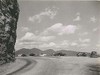 Pisgah Ledge Range
October 1955
-
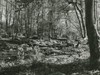
 Polly Woods Ordinary
October 9, 1955
-
 #22, Picnic Area
October 9, 1955
-
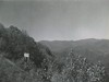
 View from Sharp Top, P/o
October 9, 1955
-
 Great Smoky Range - Panorama (Left Section of 3)
October 10, 1955
-
 Great Smoky Range - Panorama (Right Section of 3)
October 10, 1955
-
 Great Smoky Range - Panorama (Middle Section of 3)
October 10, 1955
-
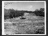 Road Construction
October 12, 1955
-
 Mt. Ash (Sorbus americana) 6'5" in circumference
October 16, 1955
-
 Mt. Ash (Sorbus Americana) 6'5" in circumference
October 16, 1955
Items in Query
Results: 100
Refine Your Search
Types (3)
Photographs (95) Maps (3) Newspaper Articles (2)Locations (32)
Museum of North Carolina Minerals (34) Milepost 408 (6) Section 2G (6) Milepost 292 (4) Grandfather Mountain (3) Section 2V (3) Undetermined (3) Craggy Gardens Visitor Center (2) Flat Top Mountain (N.C.) (2) Gillespie Gap (2) Milepost 294 (2) Milepost 296 (2) Milepost 306 (2) Milepost 362 (2) Milepost 373 (2) Milepost 409 (2) Section 2Y (2) Spruce Pine (2) Beacon Heights (1) Blowing Rock (1) Craggy Picnic Area (1) Devil's Courthouse (1) Milepost 293 (1) Milepost 317 (1) Milepost 330 (1) Milepost 331 (1) Milepost 359 (1) Peaks of Otter (1) Peaks of Otter Picnic Area (1) Section 2L (1) Section 2R (1) Sharp Top Overlook (1)Sections (13)
2L (39) 2G (13) 2P (8) 2H (7) 2T (6) 2J (4) 2V (4) 1K (3) 2K (2) 2U (2) 2Y (2) 2F (1) 2R (1)Counties (9)
Mitchell (38) Watauga (18) Buncombe (9) Avery (7) Haywood (6) Transylvania (6) Bedford (3) McDowell (3) Jackson (2)

