
Driving Through Time - The Digital Blue Ridge Parkway

Search Results:
-
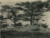 View from Highest Point in Cumberland Knob
August 1936
-
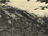 Wildcat Rocks
August 3, 1936
-
 Bridge Site #6, Southwest Wing Wall, Pine Creek Bridge No. 6
August 4, 1936
-
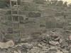
 Hand-placed rock wall
August 20, 1936
-
 Rock wall on side of road
August 23, 1936
-
 Early Construction
August 24, 1936
-
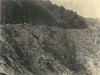
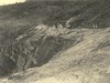
 View of Rock cut looking south
September 1936
-
 View looking south along Ice Rock section of parkway
September 11, 1936
-
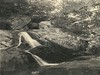 Falls in Basin Creek Bluff Park
September 11, 1936
-
 View looking north along cut through Ice Rock section of Parkway near Bluffs Park area
September 11, 1936
Items in Query
Results: 100
Refine Your Search
Types (1)
Photographs (100)Locations (29)
Section 2C (33) Section 2A (11) Milepost 242 (9) Cumberland Knob (4) Devil's Garden (4) Milepost 237 (4) Milepost 227 (3) Milepost 234 (3) Section 2B (3) Air Bellows Gap (2) Doughton Park (2) Junction of 2A/2B (2) Milepost 228 (2) Milepost 229 (2) Milepost 230 (2) Basin Creek (1) Bluffs (1) Brinegar Cabin (1) Intersection of Blue Ridge Parkway and North Carolina State Route 18 (near Laurel Springs, N.C.) (1) Mahogany Rock (1) Milepost 217 (1) Milepost 221 (1) Milepost 224 (1) Milepost 225 (1) Milepost 233 (1) Milepost 238 (1) Milepost 240 (1) Milepost 244 (1) Wildcat Rocks Overlook (1)Sections (3)
2C (56) 2A (30) 2B (12)Counties (1)
Alleghany (100)

