
Driving Through Time - The Digital Blue Ridge Parkway

Search Results:
-
 Bluffs Coffee Shop & Service Station
20th Century
-
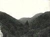
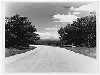 Blue Ridge Parkway near the Virginia - North Carolina Line
20th Century
-
 Little Stone Mountain
20th Century
-
 Old Still in Doughton Park
20th Century
-
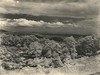
 Fisher's Peak from Cumberland Knob
20th Century
-
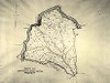 Typical Sheet Property Map
20th Century
-
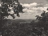
 Stone Mountain Views
20th Century
-
 Low Gap, NC
20th Century
-
 Stone Mountain
20th Century
-
 Comfort Station Upper Picnic Area
20th Century
Items in Query
Results: 1027
Refine Your Search
Types (1)
Photographs (1027)Locations (61)
Doughton Park (124) Section 2C (121) Section 2A (71) Cumberland Knob (65) Brinegar Cabin (50) Mahogany Rock (50) Milepost 237 (37) Milepost 229 (31) Milepost 217 (30) Milepost 238 (30) Milepost 224 (27) Milepost 241 (23) Bluffs (22) Milepost 225 (20) Milepost 242 (20) Milepost 221 (17) Milepost 232 (16) Milepost 227 (15) Milepost 228 (15) Milepost 234 (15) Milepost 218 (13) Milepost 239 (13) Stone Mountain (12) Fox Hunters Paradise (11) Milepost 222 (11) Milepost 230 (11) Section 2B (11) Milepost 231 (10) Milepost 240 (10) Wildcat Rocks Overlook (8) Air Bellows Gap (7) Milepost 220 (7) Bluffs Coffee Shop (6) Bluffs Lodge (6) Bull Head Mountain (6) Devil's Garden (6) Little Glade Pond (6) Milepost 219 (6) Milepost 223 (6) Milepost 226 (6) Milepost 247 (6) Bluff Park (4) Bluff Park Maintenance Area (4) Hare Mill Pond (4) Meadow Fork Valley (4) Pine Creek Bridge #4 (4) Caudill Cabin (3) Deep Gap (3) Fishers Peak (3) Milepost 233 (3) Milepost 244 (3) Alligator Back (2) Intersection of Blue Ridge Parkway at North Carolina State Route 18 (near Ennice, N.C.) (2) Junction of 2A/2B (2) Milepost 243 (2) Roaring Gap (2) Glade Valley (1) Intersection of Blue Ridge Parkway and North Carolina State Route 18 (near Laurel Springs, N.C.) (1) NC State Line (1) R.L. Martin Tract (1) Roaring Gap Hotel (1)Sections (3)
2C (499) 2A (373) 2B (153)Counties (1)
Alleghany (1027)

