
Driving Through Time - The Digital Blue Ridge Parkway

Search Results:
-
Land Use Map
1946
-
 Scenic View of Parkway
1946
-
Land Use Map
1946
-
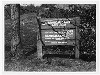
 Interpretive Sign at Wildcat Rocks
March 1946
-
 Brinegar Cabin and Loom
March 1946
-
 Brinegar Cabin and Loom
March 1946
-
 Picnic Group, Cumberland Knob
June 1946
-
 Brinegar Cabin
June 1946
-
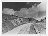 Parkway through Doughton Park
June 1946
-
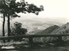 View from Fox Hunters Paradise Overlook
June 1946
Items in Query
Results: 250
Refine Your Search
Types (2)
Photographs (243) Maps (7)Locations (37)
Doughton Park (63) Cumberland Knob (17) Milepost 238 (15) Wildcat Rocks Overlook (15) Section 2A (14) Bluffs Coffee Shop (13) Fox Hunters Paradise (11) Mahogany Rock (11) Bluffs (10) Bluffs Lodge (9) Brinegar Cabin (9) Bluff Park (7) Little Glade Pond (5) Milepost 217 (5) Milepost 228 (4) Milepost 242 (4) Roaring Gap (4) Caudill Cabin (3) Milepost 220 (3) Milepost 241 (3) Section 2B (3) Air Bellows Gap (2) Alligator Back (2) Devil's Garden (2) Hare Mill Pond (2) Intersection of Blue Ridge Parkway at North Carolina State Route 18 (near Ennice, N.C.) (2) Section 2C (2) Bluff Park Maintenance Area (1) Intersection of Blue Ridge Parkway and North Carolina State Route 18 (near Laurel Springs, N.C.) (1) Milepost 218 (1) Milepost 219 (1) Milepost 229 (1) Milepost 234 (1) Milepost 239 (1) Milepost 243 (1) Milepost 247 (1) NC State Line (1)Sections (3)
2C (160) 2A (64) 2B (26)Counties (1)
Alleghany (250)

