
Driving Through Time - The Digital Blue Ridge Parkway

Search Results:
-
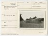
 Barn opposite swimming pool
April 11, 1935
-
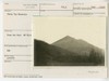 Sharp Top Mountain
April 18, 1935
-
 View toward Roanoke from point in proposed centerline of Parkway between Lynchburg Road and Coyner's Mountain
August 1936
-
 View toward Coyner's Mtn. from a point proposed centerline of Parkway
August 1936
-
 Wood piles
June 2, 1939
-
 Wood pile
June 2, 1939
-
 Grade separation structure. Detail of stone masonry north elevation
August 8, 1941
-
 Grade elevation structure. South elevation
August 18, 1941
-
 Grade separation structure. Peculiar reverse of parapet on outside curve
August 18, 1941
-
 Grade separation structure. Detail west abutment
August 18, 1941
Items in Query
Results: 94
Refine Your Search
Types (1)
Photographs (94)Locations (21)
Milepost 85 (18) Purgatory Overlook (10) Milepost 91 (9) Harveys Knob Overlook (8) Peaks of Otter Maintenance Area (8) Buchanan (Va.) (5) Milepost 100 (5) Milepost 84 (5) Johnson Farm (Va.) (4) Milepost 88 (3) Milepost 96 (3) Mills Gap Overlook (3) Iron Mine Hollow (Va.) (2) Milepost 107 (2) Milepost 92 (2) Section 1L (2) Black Rock Hill Overlook (1) Intersection of Blue Ridge Parkway at U.S. Route 221 (near Blue Ridge, Va.) (1) Milepost 101 (1) Milepost 80 (1) Quarry Knob Overlook (1)Sections (4)
1K (44) 1J (33) 1L (10) 1M (2)Counties (1)
Botetourt (94)

