
Driving Through Time - The Digital Blue Ridge Parkway

Search Results:
-
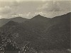 Rich Knob From scenic road
June 9, 1935
-
 Cutting by State Right of way party
April 15, 1937
-
 Cut Road
September 14, 1937
-
 Retaining Wall
September 14, 1937
-
 Extensive fill scars developing in heavy (rock) construction
March 8, 1938
-
 Fill scar, slide area and overcast material
June 25, 1938
-
 North end of former tunnel
November 8, 1938
-
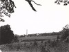 Oteen from Headquarters Site
June 1940
-
 Asheville Headquarters Site
June 1940
-
 Headquarters Site
June 1940
Items in Query
Results: 81
Refine Your Search
Types (1)
Photographs (81)Locations (34)
Craggy Gardens (17) Craggy Gardens Visitor Center (12) Craggy Pinnacle (6) Milepost 374 (3) Milepost 388 (3) Section 2P (3) Bee Tree Gap (2) Craggy Dome (2) Craggy Mountains (2) Craggy Picnic Area (2) Craggy Pinnacle Tunnel (2) Lanes Pinnacle Parking Overlook (2) Milepost 358 (2) Milepost 365 (2) Milepost 369 (2) Black Mountain (1) Craggy Dome Parking Overlook (1) Craggy Flats (1) Craggy Knob (1) French Broad River (1) Milepost 359 (1) Milepost 360 (1) Milepost 367 (1) Milepost 368 (1) Milepost 371 (1) Milepost 375 (1) Milepost 380 (1) Milepost 382 (1) Milepost 398 (1) Oteen (1) Pinnacle Gap (1) Rich Knob (1) Section 2Q (1) Section 2T (1)Sections (6)
2P (68) 2Q (5) 2R (3) 2N (2) 2S (2) 2T (1)Counties (1)
Buncombe (81)

