
Driving Through Time - The Digital Blue Ridge Parkway

Search Results:
-
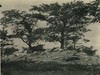 View from Highest Point in Cumberland Knob
August 1936
-
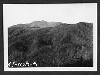
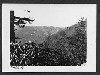
 View from Top Looking Direction of Fishers Peak
August 1936
-
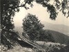
 View of Trail Leading to Cumberland Knob from the Parking Area
August 31, 1936
-
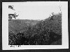
 Watershed
1940
-
 CCC Duck Pond & Messhall?
1940s
-
 Cattle belonging to Mrs. C.H. Wright committing trespass
March 17, 1940
-
 Gray Fox Cub
May 1941
-
 Proposed Location of 2-G
November 27, 1941
-
 Line "A" near Ridge at Grandfather Mountain
December 8, 1941
-
 Proposed "A" Line of Section 2-G near Blowing Rock
December 9, 1941
Items in Query
Results: 36
Refine Your Search
Types (1)
Photographs (36)Locations (17)
Peaks of Otter (6) Cumberland Knob (5) Doughton Park (3) Milepost 416 (3) Blowing Rock (2) Craggy Gardens Visitor Center (2) Fox Hunters Paradise (2) Milepost 125 (2) Milepost 408 (2) Section 2G (2) Bluff Park Maintenance Area (1) Grandfather Mountain (1) Milepost 411 (1) Milepost 415 (1) Section 2A (1) Section 2U (1) Soco Gap (1)Sections (11)
2A (8) 1K (6) 2U (6) 2C (4) 1N (2) 2F (2) 2G (2) 2P (2) 2T (2) 2H (1) 2Y (1)Counties (8)
Alleghany (12) Bedford (6) Transylvania (6) Watauga (4) Haywood (3) Buncombe (2) Roanoke (2) Avery (1)

