
Driving Through Time - The Digital Blue Ridge Parkway

Search Results:
-
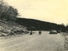 Balsam, grading and Rangers Smith and Liles
July 1944
-
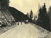 Balsam, Grading, and Ranger Smith and Liles
July 1944
-
 Parkway Entrance Sign
September 1948
-
 Flame Azalea
1950s
-
 Ranger and Visitors at Mabry Mill
June 1950
-
 Bus station
1952
-
 Housekeeping Cabins
1952
-
 Shenandoah Valley Overlook -- Bill Orr and visitor
June 1956
-
 Orientation Display, Bill Orr in picture
June 1956
-
 Craggy Gardens Info Building
July 1956
Items in Query
Results: 179
Refine Your Search
Types (1)
Photographs (179)Locations (42)
Crabtree Meadows (24) Museum of North Carolina Minerals (20) Peaks of Otter (14) Sharp Top Mountain (Va.) (14) Milepost 320 (13) Mabry Mill (Va.) (11) Peaks of Otter Visitor Center (8) Section 2J (7) Julian Price Memorial Park (6) Linville Falls (5) Harveys Knob Overlook (4) Asheville (3) Craggy Gardens Visitor Center (3) Doughton Park (3) Flat Rock Overlook (3) Milepost 185 (3) Milepost 330 (3) Milepost 409 (3) Peaks of Otter Campground (3) Balsam Gap (2) Milepost 359 (2) Milepost 86 (2) Rocky Knob (Va.) (2) Shenandoah Valley Parking Overlook (2) Undetermined (2) Gillespie Gap (1) Intersection of Blue Ridge Parkway at Virginia State Route 43 (1) Johnson Farm (Va.) (1) Milepost 0 (1) Milepost 227 (1) Milepost 238 (1) Milepost 317 (1) Milepost 407 (1) Milepost 408 (1) Milepost 420 (1) Milepost 467 (1) Oteen (1) Peaks of Otter Bus Station and Camp Store (1) Peaks of Otter Lodge (Va.) (1) Rocky Knob Cabins (1) Section 2Q (1) Sharp Top Overlook (1)Sections (20)
1K (50) 2L (24) 2M (24) 2J (16) 2K (13) 1T (12) 2G (6) 2P (5) 2C (4) 1B (3) 1U (3) 2R (3) 2U (3) 1S (2) 2Q (2) 2T (2) 2X (2) 2A (1) 2V (1) 2Z (1)Counties (14)
Bedford (45) Mitchell (36) McDowell (25) Avery (16) Floyd (11) Buncombe (10) Patrick (6) Watauga (6) Alleghany (5) Botetourt (5) Haywood (4) Augusta (3) Transylvania (3) Swain (2)

