
Driving Through Time - The Digital Blue Ridge Parkway

Search Results:
-
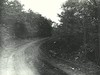 Resort Road Construction - Air Bellows
August 1974
-
 Clifford C. Bailey outbuilding rear 3/4 view
August 22, 1975
-
 Brinegar Cabin & Shed
August 22, 1975
-
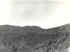 View near Mahogany Rock where homes are to be sold and removed
June 1977
-
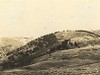
 View near Mahogany Rock where homes are to be removed
June 1977
-
 View near Mahogany Rock where homes close to Parkway are to be removed
June 1977
-
 View of The Bluffs looking north from point 200 feet off of the parkway near Alligator Back.
-
 Saddle just beyond Deep Gap
-
 Brush Creek Bridge
-
 Deep Gap, looking west
Items in Query
Results: 270
Refine Your Search
Types (1)
Photographs (270)Locations (48)
Section 2C (45) Doughton Park (33) Section 2A (27) Cumberland Knob (17) Bluffs (10) Milepost 225 (7) Milepost 242 (7) Air Bellows Gap (6) Mahogany Rock (6) Milepost 217 (6) Meadow Fork Valley (5) Milepost 229 (5) Milepost 237 (5) Milepost 241 (5) Wildcat Rocks Overlook (5) Alligator Back (4) Fox Hunters Paradise (4) Junction of 2A/2B (4) Milepost 218 (4) Milepost 226 (4) Milepost 232 (4) Section 2B (4) Stone Mountain (4) Bull Head Mountain (3) Caudill Cabin (3) Deep Gap (3) Fishers Peak (3) Milepost 221 (3) Milepost 227 (3) Milepost 247 (3) Bluff Park (2) Brinegar Cabin (2) Devil's Garden (2) Hare Mill Pond (2) Intersection of Blue Ridge Parkway and North Carolina State Route 18 (near Laurel Springs, N.C.) (2) Little Glade Pond (2) Milepost 219 (2) Milepost 224 (2) Milepost 228 (2) Milepost 240 (2) Intersection of Blue Ridge Parkway at North Carolina State Route 18 (near Ennice, N.C.) (1) Milepost 222 (1) Milepost 223 (1) Milepost 231 (1) Milepost 233 (1) Milepost 234 (1) Milepost 238 (1) Milepost 239 (1)Sections (3)
2C (135) 2A (96) 2B (35)Counties (1)
Alleghany (270)

