
Driving Through Time - The Digital Blue Ridge Parkway

Search Results:
-
Pilot Knob Development & Trails
1949
-
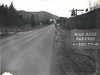
 Showing traffic signs as existing Dec 1949
December 8, 1949
-
 Showing traffic signs as existing Dec 1949
December 8, 1949
-
 Showing traffic signs as existing Dec 1949
December 8, 1949
-
 Showing traffic signs as existing Dec. 1949
December 8, 1949
-
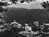
 Linville Valley from Flat Rock Overlook
1950
-
 Chestoa View PO
1950
-
 Grandfather Mountain
1950s
-
 Looking toward Grandfather from Flat Rock
1950
-
 Chestoa View PO
1950
Items in Query
Results: 100
Refine Your Search
Types (4)
Photographs (64) Newspaper Articles (31) Maps (4) Drawings, Plans, and Projections (1)Locations (17)
Grandfather Mountain (37) Flat Rock Overlook (8) Beacon Heights (7) Linville Falls (7) Milepost 317 (7) Section 2J (6) Chestoa View Parking Area (5) Intersection of Blue Ridge Parkway at U.S. Route 221 (near Linville, N.C.) (5) Milepost 312 (5) Linville (3) Milepost 306 (3) Milepost 308 (2) Milepost 305 (1) Milepost 309 (1) Milepost 319 (1) Section 2H (1) Yonhalossee Road (1)Sections (5)
2J (46) 2H (42) 2K (6) 2F (5) 2G (1)Counties (1)
Avery (100)

