
Driving Through Time - The Digital Blue Ridge Parkway

Search Results:
-
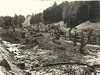
 General ground conditions showing stream conditions
April 16, 1936
-
 Type #1 headwall, single
April 16, 1936
-
Type #1 Headwall, Single
April 16, 1936
-
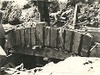 Arch-cut Stone, Double Box Culvert
April 16, 1936
-
 General Ground Conditions Showing Stream Conditions
April 16, 1936
-
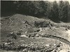
 General ground conditions, showing cut-over ground and erosion, also pine coming back.
April 16, 1936
-
 Arch + cut stone - double box culvert
April 16, 1936
-
 Type #3 headwall, single
April 16, 1936
-
 Early Construction
April 17, 1936
-
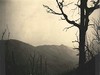 The Bluff, View of Basin Cedar Ridge
April 20, 1936
Items in Query
Results: 353
Refine Your Search
Types (2)
Photographs (352) Newspaper Articles (1)Locations (42)
Section 2A (82) Section 2C (41) Cumberland Knob (40) Milepost 225 (18) Milepost 224 (17) Milepost 217 (13) Milepost 227 (11) Milepost 218 (10) Milepost 228 (10) Milepost 232 (9) Doughton Park (8) Milepost 222 (7) Milepost 226 (7) Hare Mill Pond (6) Milepost 229 (6) Milepost 231 (6) Bluffs (5) Milepost 240 (5) Milepost 223 (4) Milepost 230 (4) Pine Creek Bridge #4 (4) Milepost 220 (3) Milepost 234 (3) Milepost 237 (3) Milepost 238 (3) Milepost 242 (3) Section 2B (3) Alleghany County (2) Basin Creek (2) Milepost 219 (2) Milepost 221 (2) Milepost 241 (2) Milepost 244 (2) Milepost 247 (2) Alligator Back (1) Fishers Peak (1) Intersection of Blue Ridge Parkway and North Carolina State Route 18 (near Laurel Springs, N.C.) (1) Intersection of Blue Ridge Parkway at North Carolina State Route 18 (near Ennice, N.C.) (1) Meadow Fork Valley (1) Milepost 233 (1) Roaring Gap (1) Roaring Gap Hotel (1)Sections (3)
2A (244) 2C (79) 2B (30)Counties (1)
Alleghany (353)

