
Driving Through Time - The Digital Blue Ridge Parkway

Search Results:
-
 12' x 12' Box Culvert at Station 347
July 27, 1940
-
 Wall detail
July 27, 1940
-
 Site of future overpass at Station 477
July 27, 1940
-
 Portion of Rock Cliff and overhand at proposed parking overlook
July 27, 1940
-
 Future Parkway Underpass Site at Aho Station
July 27, 1940
-
 View into Blowing Rock town dump
July 27, 1940
-
 View from Blowing Rock town dump
July 27, 1940
-
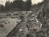 Flood Damage
August 17, 1940
-
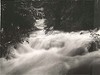 Shouls Creek during high water
August 17, 1940
-
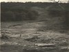 Flood damage. Slide started above Parkway
August 17, 1940
Items in Query
Results: 109
Refine Your Search
Types (3)
Photographs (104) Maps (3) Drawings, Plans, and Projections (2)Locations (21)
Milepost 285 (18) Section 2F (14) Moses H. Cone Memorial Park (13) Flat Top Manor (11) Blowing Rock (9) Section 2G (7) Bass Lake (6) Milepost 290 (6) Intersection of Blue Ridge Parkway at U.S. Route 221 (near Blowing Rock, N.C.) (5) Milepost 292 (5) Milepost 276 (2) Milepost 283 (2) Milepost 288 (2) Milepost 293 (2) Aho Station (1) Bamboo Gap (1) Flat Top Mountain (N.C.) (1) Goshen Creek Viaduct (1) Milepost 274 (1) Milepost 286 (1) Milepost 289 (1)Sections (4)
2F (61) 2G (40) 2H (5) 2E (3)Counties (1)
Watauga (109)

