
Driving Through Time - The Digital Blue Ridge Parkway

Search Results:
-
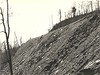 Show slope. Figure at top to figure holding white paper, Extreme lower left, marks course
February 23, 1941
-
 Alignment of road. Far figure, wheel of R side; middle figure, start of plunge; near figure, directly above wreck.
February 23, 1941
-
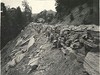 Back of wall. Sample section of guard wall
July 1, 1941
-
 Top and inside of wall. Sample section of guard wall.
July 1, 1941
-
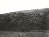
 Gully control (after)
July 26, 1941
-
 Gully control (after)
July 26, 1941
-
 Gully control (afer)
July 26, 1941
-
 Gully control (after)
July 26, 1941
-
 Gully control (after) Beng, N.C.
November 1941
-
 Gully and sheet erosion (work started)
November 1941
Items in Query
Results: 47
Refine Your Search
Types (1)
Photographs (47)Locations (14)
Milepost 251 (13) Milepost 268 (8) Section 2E (6) Section 2D (5) Laurel Fork Viaduct (2) Milepost 248 (2) Milepost 257 (2) Milepost 261 (2) Milepost 263 (2) Daniels Gap (1) Milepost 250 (1) Milepost 252 (1) Milepost 260 (1) Northwest Trading Post (1)Sections (2)
2D (30) 2E (17)Counties (1)
Ashe (47)

