
Driving Through Time - The Digital Blue Ridge Parkway

Search Results:
-
Land Acquisition Maps Section 2-Q
1948
-
 Riceville Road Overpass
1952
-
 Bull Creek and Swannanoa Valleys from Tanbark Ridge
March 4, 1956
-
 Swan Mountains - Tanbark Ridge O.L.
March 4, 1956
-
 Asheville Maint. Area (Before const. of permanent bldgs.)
August 1956
-
 Asheville Main. Area (before const. of permanent bldgs.)
August 1956
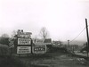
-
 Billboards
February 9, 1957
-
 Billboards
February 9, 1957
-
 Billboards
February 9, 1957
-
 Fill Slide-Photo #2 was taken about 3 minutes after photo #1 (Photo #2)
April 5, 1957
Items in Query
Results: 104
Refine Your Search
Types (2)
Photographs (100) Maps (4)Locations (11)
Oteen (31) Folk Art Center (25) Intersection of Blue Ridge Parkway at U.S. Route 70 (12) Section 2Q (9) Milepost 382 (7) Milepost 377 (6) Tanbark Ridge Overlook (4) Elk Mountain Scenic Road (3) Milepost 380 (3) Swannanoa Storage Area (3) Rich Knob (1)Sections (1)
2Q (104)Counties (1)
Buncombe (104)

