
Driving Through Time - The Digital Blue Ridge Parkway

Search Results:
-
 Dam Bed
1930s
-
 Bridge Construction
1930s
-
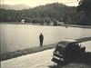 Bass Lake at Cone Park with boat house Spillway & dam in background
1930s
-
 Construction of Pier #3
1930s
-
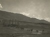 Cold Spring Valley
1930s
-
 Bridge Construction
1930s
-
 South tunnel portal
1930s
-
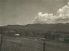 Cold Spring Mtn.
1930s
-
 Moses H. Cone Memorial Park, panorama
December 20, 1934
-
 Cone Estate
December 20, 1934
Items in Query
Results: 364
Refine Your Search
Types (3)
Photographs (352) Maps (11) Newspaper Articles (1)Locations (45)
Flat Top Manor (61) Moses H. Cone Memorial Park (60) Section 2G (32) Milepost 285 (24) Section 2F (15) Julian Price Memorial Park (14) Milepost 276 (14) Milepost 296 (13) Blowing Rock (12) Milepost 292 (11) Milepost 294 (11) Milepost 274 (10) Bass Lake (8) Section 2E (7) Grandfather Mountain (6) Sandy Flat (6) Section 2H (6) Intersection of Blue Ridge Parkway at U.S. Route 221 (near Blowing Rock, N.C.) (5) Aho Station (4) Milepost 290 (4) Flat Top Mountain (N.C.) (3) Milepost 271 (3) Bamboo Gap (2) Gillespie Gap (2) Milepost 266 (2) Milepost 270 (2) Milepost 272 (2) Milepost 286 (2) Milepost 288 (2) Milepost 293 (2) Milepost 295 (2) Milepost 297 (2) Watauga County (2) Deep Gap (1) E.B. Jeffress Park (1) Goshen Creek Viaduct (1) Milepost 269 (1) Milepost 275 (1) Milepost 283 (1) Milepost 289 (1) Milepost 307 (1) Milepost 392 (1) Raven Rock Overlook (1) Sims Pond (1) Undetermined (1)Sections (8)
2G (215) 2F (76) 2E (43) 2H (23) 2L (2) 2B (1) 2J (1) 2R (1)Counties (7)
Watauga (327) Avery (13) Wilkes (11) Ashe (7) McDowell (2) Alleghany (1) Buncombe (1)

