
Driving Through Time - The Digital Blue Ridge Parkway

Search Results:
-
 Early Construction
November 1, 1935
-
 Face of Sample Wall, Showing Raked Joints and Over 'Dressed Stone,' Giving a Hard, Formal Appearance
November 12, 1935
-
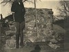 Back of sample wall, showing same stone laid in a more informal treatment, etc
November 13, 1935
-
 General view construction through low area
November 26, 1935
-
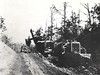
 General view of construction rough grading
November 26, 1935
-
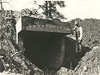
 Box culvert 8' x 6', 15° skew
November 26, 1935
-
 Rock filled tiled drain left of center line
November 26, 1935
-
 Box culvert, 8' x 6', 15° skew
November 26, 1935
-
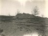 Stripped area and top soil storage pile
November 26, 1935
-
 Top soil stripping operations
November 26, 1935
Items in Query
Results: 490
Refine Your Search
Types (3)
Photographs (483) Maps (4) Drawings, Plans, and Projections (3)Locations (23)
Section 2A (156) Cumberland Knob (79) Milepost 224 (33) Milepost 225 (31) Milepost 229 (26) Milepost 217 (23) Milepost 218 (16) Milepost 227 (16) Cumberland Knob Park (15) Milepost 228 (14) Milepost 226 (13) Milepost 222 (11) Milepost 221 (10) Devil's Garden (7) Hare Mill Pond (7) Milepost 219 (7) Milepost 223 (7) Pine Creek Bridge #4 (6) Milepost 220 (4) Fox Hunters Paradise (3) R.L. Martin Tract (3) Fishers Peak (2) Intersection of Blue Ridge Parkway at North Carolina State Route 18 (near Ennice, N.C.) (1)Sections (1)
2A (490)Counties (2)
Alleghany (475) Surry (15)

