
Driving Through Time - The Digital Blue Ridge Parkway

Search Results:
-
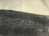
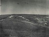 Gully and sheet erosion, large pasture with active sheet erosion.
September 1942
-
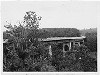
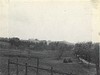 Land plowed for corn
Spring 1944
-
 Typical mountain hay meadow Peak Creek Looking pky south.
Spring 1944
-
Land plowed for corn. S.J. Miller lease. Looking north on pkwy.
Spring 1944
-
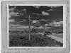 Mileage Post at Bluff N.C.
1946
-
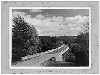
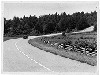 Scenic Views of the Parkway
1946
-
 Laurel Fork Bridge
1946
-
 Bridges - NC
1946
-
 "After picture" shows same area controlled by pine brush mulching and seeding to Lespedeza sericea. Before picture neg# 5442
March 1946
-
 Parkway Across West Fork of New River near Jefferson, N.C.
June 1946
Items in Query
Results: 63
Refine Your Search
Types (2)
Photographs (61) Maps (2)Locations (12)
Milepost 251 (13) Sheets Cabin (13) Northwest Trading Post (10) Section 2D (9) Milepost 257 (6) Milepost 248 (3) Laurel Fork Viaduct (2) Laurel Springs (2) Milepost 261 (2) Milepost 250 (1) Milepost 252 (1) Milepost 260 (1)Sections (1)
2D (63)Counties (1)
Ashe (63)

