
Driving Through Time - The Digital Blue Ridge Parkway

Search Results:
-
 View of Alligator Back from point down the hill on the east side of the parkway
October 20, 1936
-
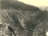
 Erosion near the Bluffs at the head of Basin Creek
October 20, 1936
-
 Erosion near the Bluffs at the head of Basin Creek
October 20, 1936
-
 View looking north across Ice Rock area
November 11, 1936
-
 View from the Bluff looking west along line of Parkway
November 11, 1936
-
 View of wide, open area on top of the Bluffs, looking north from point near Wild Cat Rocks
November 11, 1936
-
 View on top of the Bluff looking east
November 11, 1936
-
 View looking south across Ice Rock toward hand-laid rock embankmen
November 11, 1936
-
 Wildcat Rocks overlook view on top where flagging is proposed
July 20, 1939
-
 Wildcat Rocks Overlook showing location of proposed paved overlook
July 20, 1939
Items in Query
Results: 57
Refine Your Search
Types (1)
Photographs (57)Locations (16)
Milepost 237 (18) Doughton Park (7) Wildcat Rocks Overlook (6) Bluffs (4) Milepost 242 (4) Basin Creek (2) Brinegar Cabin (2) Caudill Cabin (2) Milepost 238 (2) Milepost 241 (2) Milepost 244 (2) Section 2C (2) Alligator Back (1) Intersection of Blue Ridge Parkway and North Carolina State Route 18 (near Laurel Springs, N.C.) (1) Meadow Fork Valley (1) Milepost 245 (1)Sections (1)
2C (57)Counties (2)
Alleghany (56) Wilkes (1)

