
Driving Through Time - The Digital Blue Ridge Parkway

Search Results:
-
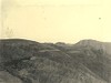
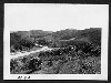 View from Station 295
1930s
-
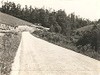
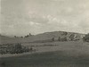
 Just West of the Bluff
1930s
-
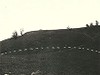
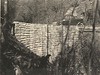
 Building the end wall
1930s
-
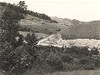
 Opposite Woodruff's
1930s
-
 Overpass near Mulberry Gap (from NC #18 on west)
June 20, 1935
-
 Overpass (NC #18) near Mulberry Gap Back
June 20, 1935
-
 Bluff Park Bridle Trail, looking toward Bluff
January 5, 1936
-
 Bluff Park Culvert Grassy Gap Road
January 5, 1936
-
 The Bluffs, Sec 2C Rhododendron Valley from Inn site (Doughton Park)
August 2, 1936
-
 Dry Masonry Stone Foundation, slaty schist.
February 19, 1936
Items in Query
Results: 823
Refine Your Search
Types (4)
Photographs (812) Maps (9) Drawings, Plans, and Projections (1) Newspaper Articles (1)Locations (24)
Doughton Park (240) Section 2C (122) Brinegar Cabin (99) Milepost 238 (42) Milepost 237 (39) Bluff Park (36) Bluffs (32) Milepost 242 (32) Milepost 241 (29) Wildcat Rocks Overlook (22) Bluff Park Maintenance Area (17) Bluffs Coffee Shop (15) Milepost 239 (13) Milepost 240 (12) Bluffs Lodge (11) Intersection of Blue Ridge Parkway and North Carolina State Route 18 (near Laurel Springs, N.C.) (11) Meadow Fork Valley (10) Milepost 245 (9) Alligator Back (8) Caudill Cabin (7) Milepost 247 (7) Milepost 244 (4) Basin Creek (3) Milepost 243 (3)Sections (1)
2C (823)Counties (2)
Alleghany (814) Wilkes (9)

