
Driving Through Time - The Digital Blue Ridge Parkway

Search Results:
-
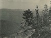 Trail view from Flat Rock Knob
April 22, 1937
-
 Cherokee Indian Reservation Is Of Great Interest To Visitors
June 13, 1937
-
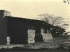
 Cumberland Knob Shelter Bldg #89
September 1937
-
 Back side of shelter
October 15, 1937
-
 Picnic Table
March 12, 1938
-
 Shelter on Top of Cumberland Knob
April 27, 1938
-
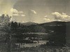
 Looking West from One of the Parking Areas South of Cumberland Knob
April 27, 1938
-
 Traversing Blue Ridge Parkway Across Carolina
July 10, 1938
-
 Linville Golf Course and Village
July 15, 1938
-
 Overpass US 21 and Access Drive
May 19, 1939
Items in Query
Results: 396
Refine Your Search
Types (4)
Photographs (361) Newspaper Articles (33) Letters (1) Oral Histories (1)Locations (77)
Section 2J (37) Museum of North Carolina Minerals (33) Mabry Mill (Va.) (25) Doughton Park (21) Milepost 407 (18) Grandfather Mountain (17) Brinegar Cabin (16) Moses H. Cone Memorial Park (13) Milepost 330 (11) Bluffs Coffee Shop (10) Cumberland Knob (10) Humpback Rocks Visitor Center and Mountain Farm (9) Milepost 409 (8) Northwest Trading Post (8) Roanoke, Va. (8) Craggy Gardens Visitor Center (7) Little Switzerland (7) Rocky Knob (Va.) (7) Crabtree Meadows (6) Fox Hunters Paradise (6) Mahogany Rock (6) Wildcat Rocks Overlook (6) Asheville (5) Chestoa View Parking Area (5) Cumberland Knob Park (5) Flat Top Manor (5) Blowing Rock (3) Intersection of Blue Ridge Parkway at U.S. Route 70 (3) Milepost 168 (3) Milepost 217 (3) Milepost 229 (3) Undetermined (3) Altapass (2) Craggy Picnic Area (2) E.B. Jeffress Park (2) Flat Rock Overlook (2) Lynn Gap (2) Milepost 272 (2) Milepost 317 (2) Milepost 323 (2) Milepost 388 (2) Milepost 411 (2) Section 2L (2) Section 2N (2) Alligator Back (1) Balsam Gap (1) Bass Lake (1) Beacon Heights (1) Bluffs Lodge (1) Cherokee Indian Reservation (1) Craggy Gardens (1) Craggy Knob (1) Craggy Pinnacle (1) French Broad River (1) Gillespie Gap (1) Great Smoky Mountains National Park (1) Headforemost Mountain Overlook (1) Intersection of Blue Ridge Parkway at U.S. Route 441 (1) Licklog Ridge Parking Overlook (1) Linville (1) Linville Falls (1) Milepost 228 (1) Milepost 235 (1) Milepost 239 (1) Milepost 336 (1) Milepost 408 (1) Mount Mitchell (1) Peaks of Otter Bus Station and Camp Store (1) Rockfish Gap Overpass (1) Section 2A (1) Section 2T (1) Section 2U (1) Section 2Y (1) Spruce Pine (1) Tanbark Ridge Overlook (1) Tomkins Knob (1) Wolf Mountain Overlook (1)Sections (28)
2L (57) 2C (56) 2J (43) 2A (29) 1T (25) 2T (20) 2G (19) 2H (18) 2P (12) 2U (11) 1B (10) 1S (10) 2K (10) 2D (8) 2B (7) 2R (7) 2M (6) 2E (5) 2N (4) 2Q (4) 2F (3) 2Z (3) 1J (1) 1K (1) 2S (1) 2V (1) 2X (1) 2Y (1)Counties (19)
Alleghany (86) Avery (66) Mitchell (52) Floyd (28) Buncombe (25) Watauga (22) Haywood (20) McDowell (16) Transylvania (12) Augusta (10) Ashe (8) Roanoke (8) Patrick (7) Wilkes (6) Surry (5) Yancey (4) Swain (3) Bedford (2) Jackson (1)

