
Driving Through Time - The Digital Blue Ridge Parkway

Search Results:
-
 View of Sharp Top Trail
April 28, 1948
-
 Views of Sharp Top Trail
April 28, 1948
-
 Construction SE wing wall
May 19, 1948
-
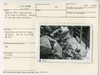
![Inlet abutement [abutment] (North) of 8x10 box culvert.](https://docsouth.unc.edu/loris/blueridgeparkway/misc/0085_p_otter_mp_86.jp2/full/100,75/0/default.jpg) Inlet abutement [abutment] (North) of 8x10 box culvert.
Inlet abutement [abutment] (North) of 8x10 box culvert.
May 19, 1948
-
 Construction of SE wing wall of 8x10 box culvert
May 19, 1948
-
 View of NW wing showing backfill as wall is constructed in height.
May 19, 1948
-
 NE wing wall construction to spring line.
May 19, 1948
-
 Construction of SE wing. Method of placing large boulders.
May 19, 1948
-
 View SW wing wall constructed to spring line
May 19, 1948
-
 Top soiling prior to seeding
May 20, 1948
Items in Query
Results: 82
Refine Your Search
Types (3)
Photographs (78) Maps (3) Newspaper Articles (1)Locations (23)
Virginia State Route 43 at Little Stony Creek (15) Moses H. Cone Memorial Park (8) Sharp Top Mountain (Va.) (8) Milepost 238 (7) Peaks of Otter Bus Station and Camp Store (6) Flat Top Manor (5) Intersection of Blue Ridge Parkway at Virginia State Route 679 (4) Peaks of Otter (4) Milepost 87 (3) Bluff Park (2) Milepost 86 (2) Section 2F (2) Section 2Q (2) Bluffs (1) Intersection of Blue Ridge Parkway at Virginia State Route 43 (1) Milepost 0 (1) Milepost 292 (1) Milepost 293 (1) Milepost 79 (1) NC State Line (1) Rockfish Gap Overpass (1) Swannanoa Gate (1) Virginia State Line (1)Sections (11)
1K (39) 2G (14) 2C (10) 1N (4) 1B (3) 2F (2) 2Q (2) 1J (1) 1W (1) 2A (1) 2H (1)Counties (8)
Bedford (40) Watauga (17) Alleghany (11) Roanoke (4) Augusta (2) Buncombe (2) Grayson (1) Nelson (1)

