
Driving Through Time - The Digital Blue Ridge Parkway

Search Results:
-
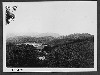
 Cone Estate Panorama
December 20, 1934
-
 Cone Estate
December 20, 1934
-
 Cone Estate
December 20, 1934
-
 Cone Estate
December 20, 1934
-
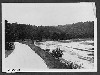
 Between Grandfather Mt and Blowing Rock, Present Road on Crest of Ridge-Proposed Parkway Location of Ridge Towards the North
June 19, 1935
-
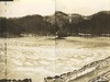
 Lake basin
June 2, 1936
-
 View of Cone Estate
June 2, 1936
-
 View of Cone Estate
June 2, 1936
-
 Gwyn's rhododendron. Heavily wooded and rocky mountain stream
June 2, 1936
-
 View from Cone Estate
June 2, 1936
Items in Query
Results: 342
Refine Your Search
Types (5)
Photographs (327) Maps (9) Drawings, Plans, and Projections (4) Newspaper Articles (1) Oral Histories (1)Locations (15)
Flat Top Manor (114) Moses H. Cone Memorial Park (82) Section 2G (44) Julian Price Memorial Park (34) Milepost 294 (16) Bass Lake (15) Milepost 296 (14) Sandy Flat (7) Milepost 293 (4) Flat Top Mountain (N.C.) (3) Milepost 295 (2) Milepost 297 (2) Sumter Cabin Creek Road (2) Yonhalossee Road (2) Sims Pond (1)Sections (1)
2G (342)Counties (2)
Watauga (340) Avery (2)

