
Driving Through Time - The Digital Blue Ridge Parkway

Search Results:
-
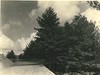 View from right bank of road looking north showing a pine wooded area through which the parkway travels.
September 11, 1936
-
 Property of Robert L. Doughton Opposite 2D
September 11, 1936
-
 Right headwall culvert, Type 3
September 21, 1936
-
 Grading, old N.C. #16 crossing
October 20, 1936
-
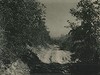
 View looking south along parkway, showing need of guard rail
October 20, 1936
-
 Typical country road through North Carolina section of parkway. This is a usual road in good weather.
October 20, 1936
-
 View of typical mountain cabin and surrounding area along road from Jefferson to Glendale Spring, NC (NC route 16)
October 20, 1936
-
 Hand-laid rock embankment after cleanup
October 25, 1936
-
 Retaining Wall Construction
November 6, 1936
-
 View looking south along Parkway
November 11, 1936
Items in Query
Results: 209
Refine Your Search
Types (2)
Photographs (202) Maps (7)Locations (24)
Milepost 248 (27) Section 2D (25) Laurel Fork Viaduct (23) Milepost 251 (15) Section 2E (15) Sheets Cabin (14) Milepost 268 (12) Milepost 261 (11) Northwest Trading Post (11) Milepost 257 (9) Milepost 250 (6) Milepost 255 (6) Milepost 262 (6) Milepost 263 (5) Gillam Gap (4) Milepost 252 (4) Milepost 256 (4) Laurel Springs (3) Daniels Gap (2) Milepost 259 (2) Sheets Gap Overlook (2) Milepost 258 (1) Milepost 260 (1) Old Route NC 16 (1)Sections (2)
2D (169) 2E (40)Counties (1)
Ashe (209)

