
Driving Through Time - The Digital Blue Ridge Parkway

Search Results:
-
 Proposed Route 18 Crossing
October 4, 1936
-
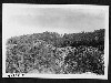
 View of Alligator Back from point down the hill on the east side of the parkway
October 20, 1936
-
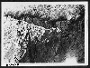
 Erosion near the Bluffs at the head of Basin Creek
October 20, 1936
-
 Erosion near the Bluffs at the head of Basin Creek
October 20, 1936
-
 Icy Rock Cut (4)
October 31, 1936
-
 Front Head Wall 437
October 31, 1936
-
 Icy Rock Curve
October 31, 1936
-
 Icy Rock Curve (2)
October 31, 1936
-
 Across Icy Rock Curve
October 31, 1936
-
 Icy Rock Cut (3)
October 31, 1936
Items in Query
Results: 511
Refine Your Search
Types (2)
Photographs (506) Maps (5)Locations (24)
Doughton Park (117) Section 2C (111) Brinegar Cabin (51) Bluff Park (29) Milepost 242 (27) Milepost 238 (25) Milepost 237 (24) Bluffs (21) Milepost 241 (19) Milepost 239 (12) Milepost 240 (11) Intersection of Blue Ridge Parkway and North Carolina State Route 18 (near Laurel Springs, N.C.) (10) Meadow Fork Valley (9) Bluff Park Maintenance Area (8) Wildcat Rocks Overlook (7) Alligator Back (6) Milepost 247 (6) Milepost 245 (5) Basin Creek (3) Caudill Cabin (3) Bluffs Coffee Shop (2) Bluffs Lodge (2) Milepost 244 (2) Milepost 243 (1)Sections (1)
2C (511)Counties (2)
Alleghany (506) Wilkes (5)

