
Driving Through Time - The Digital Blue Ridge Parkway

Search Results:
-
 View showing small pine trees cut by the owner, Wright property
August 1936
-
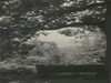
 View of small waterfall. Camera at intersection of trail and stream
August 1936
-
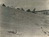
 View from Highest Point in Cumberland Knob
August 1936
-
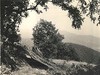
 View from Cumberland Knob
August 1936
-
 View along trail
August 1936
-
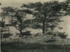
 Wright property. View showing small pine trees cut by the owner
August 1936
-
 Bench along trail at a point 100 yards from picnic area.
August 1936
-
 Waterfall Cumberland Knob
August 1936
-
 Small waterfall, Camera placed at intersection of trail and stream
August 1936
-
 View from Top Looking Direction of Fishers Peak
August 1936
Items in Query
Results: 67
Refine Your Search
Types (1)
Photographs (67)Locations (20)
Cumberland Knob (16) Milepost 218 (6) Section 2A (6) Cumberland Knob Park (5) Milepost 217 (5) Fox Hunters Paradise (3) Milepost 220 (3) Milepost 224 (3) Milepost 228 (3) Milepost 219 (2) Milepost 222 (2) Milepost 223 (2) Milepost 225 (2) Milepost 226 (2) Pine Creek Bridge #4 (2) Fishers Peak (1) Hare Mill Pond (1) Intersection of Blue Ridge Parkway at North Carolina State Route 18 (near Ennice, N.C.) (1) Milepost 227 (1) Milepost 229 (1)Sections (1)
2A (67)Counties (2)
Alleghany (62) Surry (5)

