
Driving Through Time - The Digital Blue Ridge Parkway

Search Results:
-
 Storage Compound Bldg #164
20th Century
-
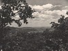
 Fox Hunter's Paradise
20th Century
-
 Low Gap, NC
20th Century
-
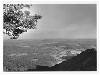
 Cumberland Knob from Norvalle Crags
20th Century
-
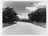 Blue Ridge Parkway near the Virginia - North Carolina Line
20th Century
-
 Fisher's Peak from Cumberland Knob
20th Century
-
 Low Gap, NC
20th Century
-
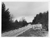 Sign for Roaring Gap, N.C.
20th Century
-
 Glade Valley
20th Century
-
 Bridge
September 18, year unknown
Items in Query
Results: 387
Refine Your Search
Types (1)
Photographs (387)Locations (25)
Section 2A (71) Cumberland Knob (65) Milepost 229 (31) Milepost 217 (30) Milepost 224 (27) Milepost 225 (20) Milepost 221 (17) Milepost 227 (15) Milepost 228 (15) Cumberland Knob Park (14) Milepost 218 (13) Fox Hunters Paradise (11) Milepost 222 (11) Milepost 220 (7) Devil's Garden (6) Milepost 219 (6) Milepost 223 (6) Milepost 226 (6) Hare Mill Pond (4) Pine Creek Bridge #4 (4) Fishers Peak (3) Intersection of Blue Ridge Parkway at North Carolina State Route 18 (near Ennice, N.C.) (2) Glade Valley (1) NC State Line (1) R.L. Martin Tract (1)Sections (1)
2A (387)Counties (2)
Alleghany (373) Surry (14)

