Driving Through Time - The Digital Blue Ridge Parkway
Search Results:
- 1.
Retaining wall, Class B, masonry. See neg# 5951
February 15, 1936 - 2.
Retaining wall, class B masonry
February 15, 1936 - 3.
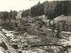
Stone work detail Class B masonry retaining wall See neg# 5951
February 15, 1936 - 4.
Retaining wall class B masonry See #5951
February 15, 1936 - 5.
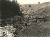
General ground conditions showing stream conditions
April 16, 1936 - 6.
Type #3 headwall, single
April 16, 1936 - 7.
General ground conditions, showing cut-over ground and erosion, also pine coming back.
April 16, 1936 - 8.
Type #1 Headwall, Single
April 16, 1936 - 9.
Arch-cut Stone, Double Box Culvert
April 16, 1936 - 10.
Arch + cut stone - double box culvert
April 16, 1936 - 11.
Type #1 headwall, single
April 16, 1936 - 12.
General ground conditions, showing erosion
April 16, 1936 - 13.
General Ground Conditions Showing Stream Conditions
April 16, 1936 - 14.
Picnic area before clearing operations
April 21, 1936 - 15.
Picnic area before clearing
April 21, 1936 - 16.
Road construction
April 27, 1936 - 17.
Cumberland Knob Picnic Area
April 28, 1936 - 18.
Cumberland Knob Picnic Area
April 28, 1936 - 19.
Bridge Tunnel
May 15, 1936 - 20.
Heavy Machinery and Construction
May 23, 1936 - 21.
Bridge Tunnel
May 23, 1936 - 22.
Bridge Construction
May 23, 1936 - 23.
Parkway Road
May 23, 1936 - 24.
Parkway Road
May 23, 1936 - 25.
Parkway Road
May 23, 1936 - 26.
Parkway Road
May 23, 1936 - 27.
Bridge Tunnel
May 23, 1936 - 28.
Masonry Wall
May 23, 1936 - 29.
Parkway Road
May 23, 1936 - 30.
Cribbing check dams with brush back-fill
May 25, 1936 - 31.
Log Cribbing and Check Dams for Erosion Control
May 25, 1936 - 32.
Special headwall, Type #1 10' x 7' Box
May 25, 1936 - 33.
Log cribbing and check dams for erosion control
May 26, 1936 - 34.
Log Cribbing and Check Dams for Erosion Control
May 26, 1936 - 35.
Log cribbing and check for erosion control
May 26, 1936 - 36.
Open grassy area on Knob, looking west
May 30, 1936 - 37.
Switchback on trail from Cumberland Knob, picnic area to gulley. Creek showing ramps.
May 30, 1936 - 38.
Clearing below Knob, Looking toward Spur
May 30, 1936 - 39.
Construction of Crib-Work for Trail
June 2, 1936 - 40.
Completed Shuttle Trail, Looking Ahead
June 15, 1936 - 41.
Cribbing of trail, almost complete "Spur Trail"
June 15, 1936 - 42.
Completed Cribbing "Spur Trail"
June 15, 1936 - 43.
Trail Route, Before Construction "Indian Grave Trail"
June 15, 1936 - 44.
Cribbing and trail, almost complete "Spur Trail"
June 15, 1936 - 45.
Completed Trail, Indian Grave Trail
June 15, 1936 - 46.
Bridge Site #10 Prior to Construction
June 23, 1936 - 47.
Channel Change at Bridge Site #10 (Section 2A)
June 23, 1936 - 48.
Coarse Stone Road in Section 2A
June 23, 1936 - 49.
Early Road Cut in Section 2A
June 23, 1936 - 50.
Bridge #6 During Construction (Section 2A)
June 23, 1936 - 51.
Detail View of Bridge #1 Construction
June 23, 1936 - 52.
Unique Culvert Near Station 262
June 23, 1936 - 53.
Culvert at Station 517
June 23, 1936 - 54.
Detail View of Bridge Site #6
June 23, 1936 - 55.
Detailed View of Bridge Abutment
June 23, 1936 - 56.
Pre-Asphalt Road in Section 2A
June 23, 1936 - 57.
Baffles
June 30, 1936 - 58.
Cement Masonry
June 30, 1936 - 59.
Right Hand Beam
July 13, 1936 - 60.
Section of Trail Under Construction - Gully Creek
July 14, 1936 - 61.
4th switch and rest bench site
July 14, 1936 - 62.
A Step Detail in Indian Grave Trail
July 14, 1936 - 63.
Bridge #1 left-handed beam
July 14, 1936 - 64.
River/Trench
July 22, 1936 - 65.
Partially Completed Overlook
July 22, 1936 - 66.
Car on winding road
July 22, 1936 - 67.
Bridge Construction in Section 2A
July 22, 1936 - 68.
"Bridge 3" Construction in Section 2A
July 22, 1936 - 69.
Bridge Construction Site in Section 2A
July 22, 1936 - 70.
Side view Bridge Construction in Section 2A
July 22, 1936 - 71.
First Parkway Crossing of NC 18, Near Sparta, NC
July 22, 1936 - 72.
Vehicle Tracks
July 22, 1936 - 73.
Pre-Asphalt Parkway Near Virginia Border
July 22, 1936 - 74.
View of Machined-Flattened Parkway
July 22, 1936 - 75.
Early Construction
July 22, 1936 - 76.
Early Construction of Bridge in Section 2A
July 22, 1936 - 77.
Line Guides
July 23, 1936 - 78.
Cement Rock Wall
July 23, 1936 - 79.
Shovel loading
July 23, 1936 - 80.
Bridge site east side looking south
July 23, 1936 - 81.
Bridge 2
July 23, 1936 - 82.
Road Between Hills
July 23, 1936 - 83.
Early Construction
July 23, 1936 - 84.
Valley
July 23, 1936 - 85.
#9 Bridge
July 23, 1936 - 86.
Wall 611
July 23, 1936 - 87.
Path North over Proposed Bridge
July 23, 1936 - 88.
Cumberland Knob
July 23, 1936 - 89.
Unpaved Road #1
July 23, 1936 - 90.
Part of #2 Abutment Face
July 23, 1936 - 91.
Bridge site #1 east side looking north
July 23, 1936 - 92.
Cumberland Knob #1
July 23, 1936 - 93.
Culvert Head Wall
July 23, 1936 - 94.
Under Drain
July 23, 1936 - 95.
Paths
July 23, 1936 - 96.
View looking south along parkway
August 1936 - 97.
View of small waterfall. Camera at intersection of trail and stream
August 1936 - 98.
View from Highest Point in Cumberland Knob
August 1936 - 99.
View from Top Looking Direction of Fishers Peak
August 1936 - 100.
Cumberland Knob
August 1936 - 101.
Fern Covered Rock along Trail
August 1936 - 102.
Wright property. View showing small pine trees cut by the owner
August 1936 - 103.
Wright Property, View Showing Small Pine Trees Cut by the Owner
August 1936 - 104.
Cumberland Knob waterfall
August 1936 - 105.
Bench along trail at a point 100 yards from picnic area.
August 1936 - 106.
View showing small pine trees cut by the owner, Wright property
August 1936 - 107.
Waterfall Cumberland Knob
August 1936 - 108.
Small waterfall, Camera placed at intersection of trail and stream
August 1936 - 109.
View from Cumberland Knob
August 1936 - 110.
View along trail
August 1936 - 111.
Fungus Growth Along Trail
August 1936 - 112.
Hiking Trail
August 1936 - 113.
Cumberland Knob Park Trail
August 1936 - 114.
Bridge site #6 Southwest wing wall
August 3, 1936 - 115.
Bridge #6 Northwest wing wall
August 4, 1936 - 116.
Bridge Site #6, Southwest Wing Wall, Pine Creek Bridge No. 6
August 4, 1936 - 117.
Buck Creek Gap
August 14, 1936 - 118.
Hand-placed rock wall
August 20, 1936 - 119.
Bridge 4, excavation site
August 22, 1936 - 120.
Bridge Construction
August 22, 1936 - 121.
Bridge and Abutment
August 22, 1936 - 122.
Bridge and Abutment Construction
August 22, 1936 - 123.
Bridge and Abutment Construction
August 22, 1936 - 124.
Bridge and Abutment Construction
August 22, 1936 - 125.
Bridge and Abutment Construction
August 22, 1936 - 126.
Curved Head Wall
August 22, 1936 - 127.
Road View
August 22, 1936 - 128.
Road View
August 22, 1936 - 129.
View of Parkway
August 22, 1936 - 130.
Ahead at site of excavation for bridge #4.
August 22, 1936 - 131.
Bridge Construction
August 22, 1936 - 132.
Early Construction
August 22, 1936 - 133.
Hare Mill Pond, scenic view
August 22, 1936 - 134.
Retaining Wall
August 22, 1936 - 135.
Bridge and Abutment Construction
August 22, 1936 - 136.
Bridge and Abutment Construction
August 22, 1936 - 137.
Hare Mill Pond, scenic view
August 22, 1936 - 138.
Bridge 10, site of construction
August 23, 1936 - 139.
Rock wall on side of road
August 23, 1936 - 140.
Excavation for tree well
August 23, 1936 - 141.
Bridge 10, site of construction
August 23, 1936 - 142.
Stone masonry wall
August 23, 1936 - 143.
Bridge 10, site of construction
August 25, 1936 - 144.
South abutment
August 26, 1936 - 145.
Stone detail
August 26, 1936 - 146.
After stream improvement
August 26, 1936 - 147.
Close-up of plant group left of parkway
August 27, 1936 - 148.
Plant group left of parkway
August 27, 1936 - 149.
Plant group left of parkway
August 27, 1936 - 150.
View of Trail Leading to Cumberland Knob from the Parking Area
August 31, 1936 - 151.
Cabin within 100' right-of-way, looking north
September 1936 - 152.
View from parkway looking east down small revine south of Knob
September 1936 - 153.
View of small water fall and stream which crosses the trail at the point where the camera is placed
September 1936 - 154.
View from edge of parkway, 1 looking north along alignment towad Cumberland Knob Park Area
September 1936 - 155.
Bridge site #6 Southeast wing wall under construction
September 4, 1936 - 156.
Bridge Site #6, Southwest Wing Wall Under Construction
September 4, 1936 - 157.
Looking east toward Pilot Mountain which is shown very faintly in middle center of picture
September 8, 1936 - 158.
View from Highest Point Looking Northeast
September 8, 1936 - 159.
View of Fishers Peak from Trail
September 8, 1936 - 160.
View looking south along parkway
September 8, 1936 - 161.
View of parkway, looking north through wooded area. One of the few places where trees meet overhead.
September 9, 1936 - 162.
Intersection of North Carolina 18 and parkway View of parkway looking north
September 9, 1936 - 163.
Brush Creek Bridge #8, Pier from south
September 16, 1936 - 164.
Brush Creek Bridge #8 Pier
September 16, 1936 - 165.
Bridge #8 Pier
September 16, 1936 - 166.
A view from the hillside opposite of the entrance to Cumberland Knob Park, looking across the Parkway to the park area
October 1936 - 167.
Stone Cement Gutter
October 5, 1936 - 168.
Construction on Bridge #8
October 5, 1936 - 169.
Top of #4 Bridge
October 5, 1936 - 170.
#3 Bridge Construction
October 5, 1936 - 171.
#4 Bridge Construction
October 5, 1936 - 172.
Wood and Stone Bridge
October 5, 1936 - 173.
Left Wing of Bridge #4
October 5, 1936 - 174.
Cement Pouring at Bridge #10
October 5, 1936 - 175.
Floor and Side Forms of Bridge #8
October 5, 1936 - 176.
Construction at Bridge #4
October 5, 1936 - 177.
Stone Cement Gutter Construction
October 5, 1936 - 178.
Stone Cement Gutter
October 5, 1936 - 179.
View of Bridge 4 Abutment
October 5, 1936 - 180.
Top of #4 Bridge
October 5, 1936 - 181.
Looking north along parkway showing rock outcropping
October 11, 1936 - 182.
View across parkway looking east into escarpment one-half mile south of Cumberland Knob
October 12, 1936 - 183.
View looking south from wooded area into open meadow area.
October 12, 1936 - 184.
View Looking South
October 12, 1936 - 185.
View looking south on parkway
October 12, 1936 - 186.
Parkway alignment, looking north
October 12, 1936 - 187.
View looking north along parkway
October 12, 1936 - 188.
Detail of rubble gutter and tile underdrain emerging
October 13, 1936 - 189.
Rubble gutter completed
October 13, 1936 - 190.
View looking south along parkway
October 13, 1936 - 191.
Rubble gutter treatment at intersection of secondary road
October 13, 1936 - 192.
View looking north on parkway
October 13, 1936 - 193.
View looking south along Parkway (Proposed cabin-gas road entrance at far end of cut on left).
October 13, 1936 - 194.
View of alignment looking north near beginning of the section.
October 13, 1936 - 195.
Crushed stone base for rubble gutter
October 13, 1936 - 196.
Gutter under construction
October 13, 1936 - 197.
View of culvert
October 13, 1936 - 198.
Gutter termination at pipe headwall
October 13, 1936 - 199.
Bridge #4 Stone detail on east side (Note scale stick)
October 13, 1936 - 200.
Simple arch culvert on west side of parkway
October 13, 1936 - 201.
General view of road and gutter
October 13, 1936 - 202.
Detail of rubble gutter - completed
October 13, 1936 - 203.
Looking north along parkway one-half mile south of Cumberland Knob Park entrance
October 13, 1936 - 204.
Road alignment looking back
October 13, 1936 - 205.
Road alignment through wooded section
October 13, 1936 - 206.
View looking north toward Pine Spur
October 13, 1936 - 207.
Looking North Along Parkway
October 14, 1936 - 208.
View looking north along Parkway
October 14, 1936 - 209.
300 feet from beginning of the section, view looking north along parkway
October 21, 1936 - 210.
Fireplace used in picnic area
October 21, 1936 - 211.
Picnic Table
October 21, 1936 - 212.
Picnic table
October 21, 1936 - 213.
View of left side, looking south, showing detail of stone work
October 22, 1936 - 214.
Near Saddle Mountain church. View of right side of two-arch culvert.
October 22, 1936 - 215.
Bridge #1 View of left side (looking south). Looking down stream
October 22, 1936 - 216.
Bridge #4 Detail of stone work; view of left side
October 22, 1936 - 217.
View of table rock formation in valley to the east of parkway
October 22, 1936 - 218.
Drop Inlet Station 29
October 28, 1936 - 219.
Work on Culvert
October 28, 1936 - 220.
Partly Completed Parking
October 28, 1936 - 221.
Right Head Wall 289
October 28, 1936 - 222.
Cut Ditch and Bank
October 28, 1936 - 223.
Work Across Intersection from 39-20
October 28, 1936 - 224.
Dressed Slopes and Road Intersection
October 29, 1936 - 225.
Bridge #6 Construction
October 29, 1936 - 226.
Bridge #9 Abutment
October 29, 1936 - 227.
Parkway at Hare Mill Pond
November 10, 1936 - 228.
Hare Mill Pond and road after clean-up
November 10, 1936 - 229.
Hare Mill Pond and secondary road
November 10, 1936 - 230.
Brush Creek Bridge #8
November 19, 1936 - 231.
Culvert at upper end of pond mill side.
November 19, 1936 - 232.
View looking across parkway from east side of bridge
November 19, 1936 - 233.
Bridge #6 Bridge from east side.
November 19, 1936 - 234.
Station 258, Sec 2B Rock fill adjacent to hand-laid rock embankment
November 19, 1936 - 235.
General view showing machinery making fill through low wet area
November 25, 1936 - 236.
Parking Overlook
December 1, 1936 - 237.
Bridge Construction
December 1, 1936 - 238.
Arch of Bridge
December 1, 1936 - 239.
Bridge Frame
December 1, 1936 - 240.
Bridge Construction
December 1, 1936 - 241.
Pine Creek Bridge #4
December 1, 1936 - 242.
Bridge Construction
December 1, 1936 - 243.
Bridge Construction
December 1, 1936 - 244.
Roadway
December 1, 1936 - 245.
Rounded Roadway
December 1, 1936 - 246.
Bridge Construction
December 1, 1936 - 247.
Bridge Construction
December 1, 1936 - 248.
Bridgeway #2 and Parkway
December 2, 1936 - 249.
Bridge No. 4
December 2, 1936 - 250.
Station 386 Bridge #4
December 12, 1936 - 251.
Station 386 Bridge #4
December 12, 1936
Refine Your Search
Types (1)
Photographs (251)Locations (20)
Section 2A (82) Cumberland Knob (40) Milepost 225 (18) Milepost 224 (17) Milepost 217 (13) Milepost 227 (11) Milepost 218 (10) Milepost 228 (10) Cumberland Knob Park (7) Milepost 222 (7) See All ResultsSections (1)
2A (251)Counties (2)
Alleghany (244) Surry (7)


