
Driving Through Time - The Digital Blue Ridge Parkway

Search Results:
-
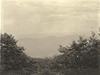 Seniard Mountain - View from Pisgah Forest
June 6, 1935
-
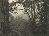 Looking Glass from Seniard Mountain
June 6, 1935
-
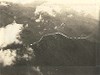
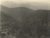 Pigeon River Valley
June 6, 1935
-
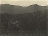
 Looking north over Pigeon Valley
June 6, 1935
-
 Pigeon River - Lower Falls
June 6, 1935
-
 Pigeon River - Lower Falls Region
June 6, 1935
-
 Court House Creek and Devils Court House
June 13, 1935
-
 Devil's Court House. Note: steep slopes on the south side contrasted to easy slopes towards north (top)
June 19, 1935
-
 Devil's Court House. Note: steep slopes on the south side contrasted to easy slopes towards north (top)
June 19, 1935
-
 Near Haywood Gap - View of Rough Butt Bald
August 22, 1935
Items in Query
Results: 73
Refine Your Search
Types (4)
Photographs (65) Newspaper Articles (4) Maps (3) Letters (1)Locations (10)
Section 2V (17) Wolf Mountain Overlook (17) Devil's Courthouse (16) Milepost 426 (6) Pisgah National Forest (6) Brevard (4) Devil's Courthouse Tunnel (3) Milepost 421 (2) Milepost 423 (1) Wolf Bald (1)Sections (1)
2V (73)Counties (1)
Transylvania (73)

