
Driving Through Time - The Digital Blue Ridge Parkway

Search Results:
-
 Mayapple Gap - Doubletop Mountain
August 11, 1936
-
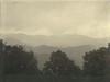 Mountains toward the south
August 11, 1936
-
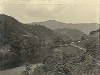 Tuckaseegee River Valley
August 12, 1936
-
 Panorama of Proposed Parkway at Point North of Webster
August 13, 1936
-
Road System Plan 2-W
1950
-
Land Acquisition Maps Section 2-W
1957
-
 Double Top Mt.
October 1959
-
Parkway Land Use Map Section 2-W
Page 1 of 1.
Items in Query
Results: 8
Refine Your Search
Types (2)
Photographs (5) Maps (3)Locations (1)
Section 2W (8)Sections (1)
2W (8)Counties (1)
Haywood (8)

