
Driving Through Time - The Digital Blue Ridge Parkway

Search Results:
-
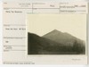
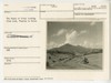
 The very top of Sharp Top
1920s
-
 Family on fence - Johnson Farm - Note Fence
1920s
-
 Bryant Family
1920s
-
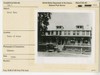 Hotel Mons
1920s
-
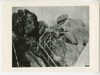
 Road up Sharp Top
July 1934
-
 Sharp Top
July 1934
-
 Sharp Top Mountain
April 18, 1935
-
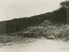
 McFalls Creek Valley
April 18, 1935
-
 The Peaks of Otter looking from road, Thaxton to Kelso
August 1936
-
 Flat Top from trail up to Sharp Top
August 1936
Items in Query
Results: 505
Refine Your Search
Types (2)
Photographs (504) Drawings, Plans, and Projections (1)Locations (37)
Peaks of Otter (105) Sharp Top Mountain (Va.) (83) Peaks of Otter Lodge (Va.) (41) Peaks of Otter Bus Station and Camp Store (38) Peaks of Otter Visitor Center (30) Milepost 86 (27) Peaks of Otter Campground (21) Virginia State Route 43 at Little Stony Creek (17) Peaks of Otter Picnic Area (14) Section 1K (14) Purgatory Overlook (10) Milepost 91 (9) Sharp Top Overlook (9) Harveys Knob Overlook (8) Milepost 87 (8) Milepost 90 (8) Milepost 98 (7) Peaks of Otter Service Station (6) Intersection of Blue Ridge Parkway at Virginia State Route 43 (4) Johnson Farm (Va.) (4) Pine Tree Overlook (4) Sharp Top Mountain Bus Shelter (4) Bobblets Gap Overlook (3) Goose Creek Valley Overlook (3) Milepost 88 (3) Milepost 93 (3) Milepost 96 (3) Milepost 97 (3) Mills Gap Overlook (3) Big Spring (Va.) (2) Iron Mine Hollow (Va.) (2) Milepost 92 (2) Milepost 95 (2) Powell Gap (2) Bearwallow Gap (1) Milepost 94 (1) Montvale Overlook (1)Sections (1)
1K (505)Counties (2)
Bedford (461) Botetourt (44)

