
Driving Through Time - The Digital Blue Ridge Parkway

Search Results:
-
 Untitled
20th Century
-
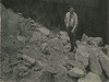
 CCC Camp
1930s
-
 Looking Down the Back Side of thru Rock Cut
April 25, 1938
-
 Pete Collenicu Adm. Ass. now with Lowe's N. Wilksboro, NC
1940s
-
 12' x 12' Box Culvert at Station 347
July 27, 1940
-
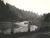 Blowing Rock Town power dam broken by rains of Aug 13, 1940
August 17, 1940
-
 Fire Tool Box
1941
-
 Land plowed for corn. S.J. Miller lease. Looking north on pkwy.
Spring 1944
-
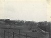
 Parkway Near Cumberland Knob
June 1946
-
 Interpretive sign for Caudill Cabin at Wildcat Rocks overlook
April 1947
Items in Query
Results: 88
Refine Your Search
Types (1)
Photographs (88)Locations (31)
Doughton Park (22) Milepost 320 (11) Museum of North Carolina Minerals (9) Asheville (4) Intersection of Blue Ridge Parkway at U.S. Route 70 (4) Milepost 331 (4) Waterrock Knob (4) Milepost 409 (3) Milepost 467 (2) Section 2G (2) Section 2J (2) Asheville Civic Center (1) Blowing Rock (1) Bluff Park (1) Cumberland Knob (1) E.B. Jeffress Park (1) Gillespie Gap (1) Intersection of Blue Ridge Parkway at North Carolina State Route 18 (near Ennice, N.C.) (1) Milepost 121 (1) Milepost 257 (1) Milepost 283 (1) Milepost 344 (1) Milepost 352 (1) Milepost 408 (1) Milepost 424 (1) Milepost 97 (1) Moses H. Cone Memorial Park (1) Rocky Knob (Va.) (1) Section 2L (1) Section 2T (1) Undetermined (1)Sections (21)
2C (23) 2L (15) 2K (11) 2R (5) 2Q (4) 2X (4) 2G (3) 2U (3) 2A (2) 2F (2) 2J (2) 2T (2) 2Z (2) 1K (1) 1M (1) 1S (1) 2D (1) 2E (1) 2M (1) 2N (1) 2V (1)Counties (16)
Alleghany (25) Mitchell (24) Buncombe (10) Watauga (5) Jackson (4) McDowell (3) Transylvania (3) Avery (2) Haywood (2) Swain (2) Ashe (1) Bedford (1) Patrick (1) Roanoke (1) Wilkes (1) Yancey (1)

