
Driving Through Time - The Digital Blue Ridge Parkway

Search Results:
-
 Virginia State highway traffic sign
20th Century
-
 Virginia State highway sign
20th Century
-
 View south-west toward Mason's Knob from proposed center line of Parkway
August 1936
-
 View from proposed center line of parkway
August 1936
-
 View taken from vicinity of proposed parkway near Yellow Mtn.
August 1936
-
 View from proposed center line of Parkway between Mason's Knob and Buck Mtn.
August 1936
-
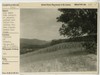
![Vichity [Vicinity] of Roanoke, Va.](https://docsouth.unc.edu/loris/blueridgeparkway/misc/0001_mp0126.jp2/full/100,75/0/default.jpg) Vichity [Vicinity] of Roanoke, Va.
Vichity [Vicinity] of Roanoke, Va.
August 1936
-
 View toward Buck Mtn. from proposed center line of Parkway between Buck Mtn. and Mason's Knob
August 1936
-
 New highway bridge over Norfolk and Western Railway
September 1936
-
 View of Mason's Knob taken from road leading to Knob from U.S. Route #11
September 1936
Items in Query
Results: 149
Refine Your Search
Types (1)
Photographs (149)Locations (23)
Elmwood Park (35) Milepost 125 (28) Roanoke, Va. (21) Milepost 128 (11) Roanoke Regional Airport (6) Dixie Caverns (5) Intersection of Blue Ridge Parkway at Virginia State Route 679 (5) Milepost 121 (5) N.W. Pugh Department Store (5) Hanging Rock (4) Milepost 126 (4) Roanoke Mountain (4) Salem (Va.) (4) Milepost 120 (2) Patrick Henry Hotel (2) Bent Mountain (1) Mason's Knob (1) Milepost 129 (1) Milepost 136 (1) Read Mountain Overlook (1) Roanoke River Bridge (Va.) (1) Sugarloaf Mountain (1) Victory Stadium (1)Sections (3)
1N (95) 1M (17) 1P (1)Counties (1)
Roanoke (149)

