
Driving Through Time - The Digital Blue Ridge Parkway

Search Results:
-
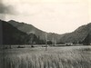
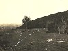 Looking Towards Sparta
20th Century
-
 layout plan grade separation
1930s
-
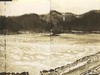
 Moses H. Cone Memorial Park, panorama
December 20, 1934
-
 Cone Estate Panorama
December 20, 1934
-
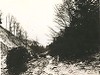 Near Aho
December 20, 1934
-
 Blowing Rock
December 20, 1934
-
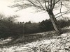
 View up valley
August 12, 1935
-
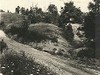 View to northwest from point shown on grading plan. Old gullied road to right
August 15, 1935
-
 Near Haywood Gap - Looking along line
August 22, 1935
-
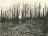 Picnic area before clearing
April 21, 1936
Items in Query
Results: 121
Refine Your Search
Types (1)
Photographs (121)Locations (49)
Mahogany Rock (20) Section 2M (14) Milepost 285 (11) Milepost 229 (6) Grandfather Mountain (5) Blowing Rock (4) Section 2A (4) Section 2C (4) Section 2G (3) Section 2Q (3) Aho Station (2) Milepost 241 (2) Milepost 248 (2) Milepost 273 (2) Milepost 290 (2) Section 2J (2) Wildcat Rocks Overlook (2) Bluff Park (1) Cherokee Indian Reservation (1) Cumberland Knob (1) Devil's Garden (1) Doughton Park (1) Folk Art Center (1) Intersection of Blue Ridge Parkway at Virginia State Route 89 (1) McKinney Gap (1) Milepost 220 (1) Milepost 234 (1) Milepost 235 (1) Milepost 237 (1) Milepost 239 (1) Milepost 254 (1) Milepost 257 (1) Milepost 258 (1) Milepost 261 (1) Milepost 262 (1) Milepost 294 (1) Milepost 313 (1) Milepost 314 (1) Milepost 317 (1) Milepost 322 (1) Milepost 417 (1) Milepost 426 (1) Milepost 45 (1) Milepost 60 (1) Moses H. Cone Memorial Park (1) Section 2B (1) Section 2D (1) Section 2W (1) Undetermined (1)Sections (19)
2B (23) 2F (19) 2M (14) 2A (13) 2C (12) 2D (7) 2G (5) 2H (5) 2J (5) 2Q (4) 2E (3) 2K (2) 1F (1) 1G (1) 1W (1) 2U (1) 2V (1) 2W (1) 2Z (1)Counties (15)
Alleghany (47) Watauga (24) Yancey (14) Avery (10) Ashe (7) Buncombe (4) Wilkes (4) Transylvania (2) Amherst (1) Grayson (1) Haywood (1) McDowell (1) Mitchell (1) Rockbridge (1) Swain (1)

