
Driving Through Time - The Digital Blue Ridge Parkway

Search Results:
-
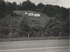
 Advertising Signs Adjacent to Parkway
1959
-
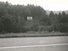
 Advertising sign adjacent to Parkway
1959
-
 Advertising signs along the Parkway
1959
-
 Advertising Sign Adjacent to Parkway
1959
-
 Advertising sign adjacent to Parkway
1959
-
 Blue Ridge Parkway Junction with U.S. 441 in Great Smoky Mountain National Park
1959
-
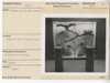 Exhibit #6 and audio units
January 9, 1959
-
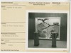 Exhibit #6 and audio units
January 9, 1959
-
 Garnets in Schist
January 14, 1959
-
 Garnets in Schist
January 14, 1959
Items in Query
Results: 235
Refine Your Search
Types (1)
Photographs (235)Locations (88)
Milepost 125 (12) Milepost 407 (10) Museum of North Carolina Minerals (10) Milepost 128 (9) Harveys Knob Overlook (8) Waterrock Knob (8) Crabtree Meadows (6) Lanes Pinnacle Parking Overlook (6) Milepost 417 (6) Sharp Top Mountain (Va.) (6) Mabry Mill (Va.) (5) Milepost 90 (5) Peaks of Otter Campground (5) Peaks of Otter Visitor Center (5) Asheville (4) Craggy Gardens (4) Gillespie Gap (4) Milepost 100 (4) Milepost 168 (4) Milepost 451 (4) Milepost 85 (4) Peaks of Otter Picnic Area (4) Roaring Gap (4) Section 2G (4) Craggy Gardens Visitor Center (3) Milepost 312 (3) Milepost 413 (3) Northwest Trading Post (3) Rocky Knob (Va.) (3) Balsam Gap (2) Bluff Mountain Tunnel (2) Devil's Courthouse (2) Doughton Park (2) Humpback Rocks Visitor Center and Mountain Farm (2) Intersection of Blue Ridge Parkway at U.S. Route 60 (2) Milepost 16 (2) Milepost 220 (2) Milepost 274 (2) Milepost 86 (2) Moses H. Cone Memorial Park (2) Mount Mitchell (2) Section 1K (2) Section 1V (2) Section 2A (2) Section 2Y (2) Sharp Top Overlook (2) Soco Gap (2) Wisemans View (2) Yankee Horse Ridge Parking Area (2) Bald Mountain (1) Buchanan (Va.) (1) Buck Creek Gap (1) Craggy Mountains (1) Intersection of Blue Ridge Parkway at Virginia State Route 679 (1) Jackson County (1) Milepost 140 (1) Milepost 145 (1) Milepost 160 (1) Milepost 167 (1) Milepost 170 (1) Milepost 217 (1) Milepost 219 (1) Milepost 28 (1) Milepost 296 (1) Milepost 317 (1) Milepost 319 (1) Milepost 330 (1) Milepost 349 (1) Milepost 353 (1) Milepost 380 (1) Milepost 398 (1) Milepost 439 (1) Milepost 469 (1) Milepost 56 (1) Milepost 93 (1) Milepost 94 (1) Milepost 95 (1) Milepost 96 (1) Montebello Maintenace Area (1) Peaks of Otter (1) Powell Gap (1) Purgatory Overlook (1) Roanoke River Bridge (Va.) (1) Section 2T (1) Section 2W (1) Section 2X (1) Victory Stadium (1) Wolf Bald (1)Sections (38)
1K (46) 1N (23) 2L (17) 2X (15) 2P (14) 2T (11) 1S (9) 2U (9) 2G (7) 2M (7) 2A (6) 1T (5) 2N (5) 1E (4) 1J (4) 1L (4) 2B (4) 2J (4) 2R (4) 2Y (4) 1G (3) 2D (3) 2V (3) 1B (2) 1D (2) 1F (2) 1V (2) 2C (2) 2E (2) 2W (2) 2Z (2) 1M (1) 1P (1) 1Q (1) 1R (1) 2K (1) 2Q (1) 2S (1)Counties (23)
Bedford (36) Roanoke (24) Buncombe (21) Botetourt (19) Haywood (16) Jackson (16) Mitchell (13) Alleghany (12) McDowell (12) Transylvania (12) Floyd (11) Watauga (9) Amherst (5) Avery (5) Patrick (4) Yancey (4) Ashe (3) Nelson (3) Rockbridge (3) Augusta (2) Carroll (2) Franklin (2) Swain (1)

