
Driving Through Time - The Digital Blue Ridge Parkway

Search Results:
-
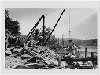 Stone Masons
1935
-
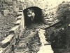
 Special Headwall, 10' x 7' R.C. Box
May 25, 1935
-
 Special headwall 10' x 7' R.C. box
May 25, 1935
-
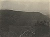 Devils Garden Showing Steep Rocky Slopes
May 31, 1935
-
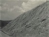
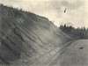 Before grading. Gullies and cave-ins. Slope too steep.
July 25, 1935
-
 Before grading. Washout ditch filled; needs transition, rounding, and drainage structure.
July 25, 1935
-
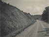
 Before grading. 1:1 cut gullying badly; too steep to grass; flatten and round for grass
July 25, 1935
-
 Before grading. Showing objectionable effect of uniform slopes and insufficient rounding
July 25, 1935
-
 Before grading. Soft gullying material above rock. Flatten expose hard rock. Wide rounding.
July 25, 1935
-
 Before grading. Gullies in fill. Soil erosive. Needs flattening.
July 25, 1935
Items in Query
Results: 589
Refine Your Search
Types (1)
Photographs (589)Locations (24)
Section 2A (172) Cumberland Knob (94) Milepost 229 (34) Milepost 224 (33) Milepost 217 (32) Milepost 225 (31) Cumberland Knob Park (26) Milepost 221 (22) Milepost 227 (18) Milepost 228 (18) Milepost 218 (17) Fox Hunters Paradise (14) Milepost 226 (13) Milepost 222 (11) Devil's Garden (9) Hare Mill Pond (9) Milepost 220 (8) Milepost 223 (7) Milepost 219 (6) Pine Creek Bridge #4 (6) Intersection of Blue Ridge Parkway at North Carolina State Route 18 (near Ennice, N.C.) (3) R.L. Martin Tract (3) Fishers Peak (2) NC State Line (1)Sections (1)
2A (589)Counties (2)
Alleghany (563) Surry (26)

