
Driving Through Time - The Digital Blue Ridge Parkway

Search Results:
-
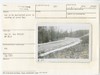
 Peaks of Otter Rte 43 relocation. Site for 8x10 culvert.
January 1947
-
 Cut to be daylighted prior to seeding of grass bay.
January 1947
-
 Peaks of Otter bus terminal. View of native stone curbing in parking area
1947
-
 Caudill Cabin Bldg. #100
1947
-
 Black Rock parking circle. Black Rock in center background.
January 1947
-
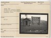 Interp. Sign. Chicken Coop (currently located at Puckett Cabin) Frame Granary in background (razed).
1947
-
 Peaks of Otter bus terminal site. Looking toward Sharp Top Road.
January 30, 1947
-
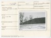
 Before Daylighting
January 30, 1947
-
 Proposed site bus terminal.
January 30, 1947
-
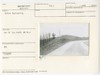
 View looking north from Sharp Top Road at a point 200 ft west of bldg. site
January 30, 1947
Items in Query
Results: 93
Refine Your Search
Types (1)
Photographs (93)Locations (37)
Peaks of Otter Bus Station and Camp Store (15) Milepost 152 (8) Peaks of Otter (7) Bass Lake (6) Milepost 84 (5) Doughton Park (3) Flat Top Manor (3) Fox Hunters Paradise (3) Section 2M (3) Caudill Cabin (2) Mabry Mill (Va.) (2) Milepost 142 (2) Milepost 168 (2) Milepost 199 (2) Milepost 217 (2) Milepost 308 (2) Milepost 88 (2) Rakes Mill Pond (2) Section 1K (2) Virginia State Route 43 at Little Stony Creek (2) Wildcat Rocks Overlook (2) Black Rock Hill Overlook (1) Milepost 136 (1) Milepost 153 (1) Milepost 159 (1) Milepost 218 (1) Milepost 220 (1) Milepost 238 (1) Milepost 241 (1) Milepost 265 (1) Milepost 271 (1) Milepost 309 (1) Milepost 312 (1) Milepost 80 (1) Milepost 85 (1) Milepost 86 (1) Section 2A (1)Sections (14)
1K (29) 1Q (9) 2C (9) 2G (9) 1J (8) 2A (8) 2J (4) 1P (3) 1R (3) 2M (3) 1S (2) 1T (2) 1V (2) 2E (2)Counties (11)
Bedford (27) Alleghany (17) Botetourt (10) Floyd (9) Franklin (9) Watauga (9) Avery (4) Yancey (3) Carroll (2) Wilkes (2) Roanoke (1)

