Daniel Boone’s Trail, Zionville
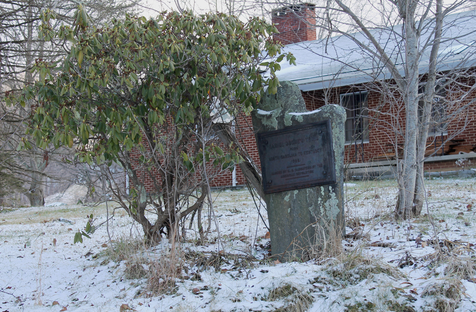
The memorial consists of a rectangular cast iron plaque attached to a larger stone slab several feet high embedded in the ground.
DANIEL BOONE’S TRAIL / FROM / NORTH CAROLINA TO KENTUCKY / 1769 / MARKED BY THE N.C. DAUGHTERS OF THE / AMERICAN REVOLUTION
November 7, 1913
36.334430 , -81.744680
View in Geobrowse
Bryan, William L., “My Trip To Zionville,” Watauga Democrat, (Boone, NC), November 13, 1913, 2
Jones, Randell. Trailing Daniel Boone, Daughters of the American Revolution Marking Daniel Boone’s Trail, 1912-1915, (Winston-Salem, NC: Daniel Boone Footsteps, 2012)
“North Carolina Daniel Boone Heritage Trail,” North Carolina Daniel Boone Heritage Trail, Inc., (accessed January 11, 2016) Link
“North Carolina Joins In Boone Trail Movement,” Asheville-Gazette News, (Asheville, NC), November 10, 1914, 3
“The Trail Taken by Boone Through State Now Marked,” News and Observer, (Raleigh, NC), July 11, 1915, 17
No
Cast Iron, stone
The marker was placed on the morning of November 7, 1913 by Mr. William L. Bryan with the assistance of Mr. Willett Adams.
Daniel Boone’s marked trail begins at Boone Cave Park in Davidson County, NC, crosses the
Yadkin River at the Shallow Ford near Huntsville, and ends at Fort Boonesborough, Kentucky
where Boone served during the American Revolution. In 1913 Daughters of the American
Revolution (DAR) Chapters placed 13 markers along the North Carolina portion of the trail
which mostly follows Old US Highway 421. Mrs. Lindsay Patterson of Winston-Salem chaired
the project that eventually erected 45 tablets in North Carolina, Tennessee, Virginia and
Kentucky. At the Cumberland Gap (Tennessee) the four states combined to erect a single
commemorative monument.
Daniel Boone is famous for exploring the American frontier beyond the Appalachian Mountains.
He blazed one of the trails that opened up areas west of the Appalachian’s to increased
European settlement. He was born in Pennsylvania in 1734, lived in the Yadkin Valley, North
Carolina from 1752-1769, where he married Rebecca Bryan, raised a large family, and traded
animal furs. He died in Missouri in 1820 and is buried in Kentucky.
The marker is in the yard of a private home on Emory Greer Road at John’s Lane between Boone and the Tennessee state line. The memorial is visible from the public right of way.
The marker is surrounded by trees and seasonal greenery.
 Know anything else about this monument that isn't mentioned here? If you have additional information on
this or any other monument in our collection fill out the form at the Contact Us link in the footer. Thank you.
Know anything else about this monument that isn't mentioned here? If you have additional information on
this or any other monument in our collection fill out the form at the Contact Us link in the footer. Thank you.