Documenting the American South Logo

Drummond's Pictorial Atlas of North Carolina:
Electronic Edition.

Drummond, Albert Y.


Funding from the Institute for Museum and Library Services supported the electronic publication of this title.


Text transcribed by Apex Data Services, Inc.
Images scanned by Melissa G. Meeks
Text encoded by Apex Data Services, Inc., Meredith Evans, Matthew Kern, and Elizabeth S. Wright
First edition, 2003
ca. 695K
Academic Affairs Library, UNC-CH
University of North Carolina at Chapel Hill,
2003.

Copyright Not Evaluated

Source Description:


(cover) Drummond's Pictorial Atlas of North Carolina.
(title page) Drummond's Pictorial Atlas of North Carolina.
Drummond, Albert Y.
148 p. incl. front., ill.
Charlotte, N.C.
Albert Y. Drummond
Winston-Salem, N.C.
Scoggins Printing Company, Inc.
1924

Call number NCC Folio -- FC917 D79 (North Carolina Collection, University of North Carolina at Chapel Hill)

"Edited and Published by Albert Y. Drummond."

        The electronic edition is a part of the UNC-CH digitization project, Documenting the American South.
        The text has been entered using double-keying and verified against the original.
        The text has been encoded using the recommendations for Level 4 of the TEI in Libraries Guidelines.
        Original grammar, punctuation, and spelling have been preserved. Encountered typographical errors have been preserved, and appear in red type.
        All footnotes are inserted at the point of reference within paragraphs.
        Any hyphens occurring in line breaks have been removed, and the trailing part of a word has been joined to the preceding line.
        All quotation marks, em dashes and ampersand have been transcribed as entity references.
        All double right and left quotation marks are encoded as " and " respectively.
        All single right and left quotation marks are encoded as ' and ' respectively.
        All em dashes are encoded as --
        Indentation in lines has not been preserved.
        Spell-check and verification made against printed text using Author/Editor (SoftQuad) and Microsoft Word spell check programs.


Library of Congress Subject Headings

Languages Used:

LC Subject Headings:


Revision History:


Illustration

[Cover Image]


Illustration

[Cover Verso Image]


Illustration

[Title Page Image]


Page 1

The Old North State Forever


                         Carolina! Carolina! Heaven's blessings attend her!
                         While we live we will cherish, protect and defend her;
                         Tho' the scorner may sneer and witlings defame her,
                         Our hearts swell with gladness whenever we name her.


                         Hurrah! hurrah! the Old North State forever,
                         Hurrah! hurrah! the good Old North State.


                         Tho' she envies not others their merited glory,
                         Yet, her name stands the foremost in liberty's story,
                         Tho' not true to herself e'er to crouch to oppression,
                         Who can yield to just rule more loyal submission?


                         Plain and artless her sons, but whose doors open faster,
                         At the knocks of the stranger or the tale of disaster?
                         How like to the rudeness of their dear native mountains
                         With rich ore in their bosoms and life in their fountains.


                         And her daughters, the queen of the forest resembling,
                         So graceful, so constant, yet to gentlest breath trembling,
                         And true lightwood at heart; let the match be applied them.
                         How they kindle and flame! O none know but who've tried them.


                         Then let all who love us, love the land that we live in,
                         As happy a region as on this side of Heaven;
                         Where plenty and freedom, love and peace, smile before us.
                         Raise, aloud, raise together, the heart thrilling chorus.


Page 2


Illustration

[Views of State Buildings]


Page 3

DRUMMOND'S
PICTORIAL ATLAS
of
NORTH CAROLINA


                         "Here's to the land of the long leaf pine,
                         The summer land where the sun doth shine;
                         Where the weak grow strong and the strong grow great,
                         Here's to down home--the 'Old North State'."

EDITED AND PUBLISHED BY
ALBERT Y. DRUMMOND
CHARLOTTE, N. C.


Page 4

Foreword

        NORTH CAROLINA, the "State of Superlatives," is a territory so large and a land so rich in Nature's endowments that few of her own people really know her. Little wonder is it, therefore, that the newcomer is amazed at the potential strength exhibited on every hand, or that the citizen of a less favored area is dazzled by the tales he hears of North Carolina's present greatness. Twenty years ago North Carolina ranked as one of the most backward of American States, while today she is perhaps the foremost of all the United States. In these twenty years North Carolina has gradually forged to the front in every line of endeavor until today the eyes of the whole nation have turned to the Tar Heel State to learn of her progress and opportunities.

        Within the past few years much has been written about North Carolina, and travelers are boosting the State far and wide, yet no attempt has been made to give the public an accurate, authentic sketch of the State embracing all the phases of her life and progress. DRUMMOND'S PICTORIAL ATLAS OF NORTH CAROLINA has been prepared expressly for the purpose of presenting to the outside world a concise, authentic and complete story of the North Carolina of today. Into this one volume has been incorporated the gist of the hundreds of items and bits of data that have been published in various forms during the past two years. DRUMMOND'S PICTORIAL ATLAS OF NORTH CAROLINA is a volume of facts only--no statements of a doubtful nature are made. Every item printed herein has been attested to by persons who are in a position to verify that particular fact. Every effort has been made to give the reader an impartial story relating the present accomplishments of the State as they really are.

        No subject can be fully portrayed without the use of illustrations, so hundreds of photographs have been reproduced in this volume illustrating the subjects described. The views found in the Atlas have been carefully selected from a collection of over eighteen hundred pictures, over half of which were photographed by the Editor. Every one of the one hundred counties of the State has been visited personally by the Editor during the past eighteen months in an endeavor to collect first hand all the data and scenes that should have a place in a volume of this kind.

        The contents of DRUMMOND'S PICTORIAL ATLAS OF NORTH CAROLINA will be found divided into three distinct sections. In the fore-part a number of subjects of State-wide importance are discussed and illustrated, while in the center section will be found a two-page display space devoted to each of the fifty-six incorporated cities of the State having a population of over twenty-five hundred people according to the 1920 United States census. In these displays an effort has been made to eliminate that flowery type of description so popular with many of the writers of today and to present to the reader the actual facts about the city in question. Each of these sketches has been verified and signed by at least two prominent citizens of that particular city. In most cases these have been the Mayor and the president of some civic organization. Further mention of these may be found below. The third section is devoted to miscellaneous subjects and contains a sketch of each county in the State, State maps and a complete list of all those manufacturing plants and features of the State that rank as distinct leaders in the South, in the United States or in the world. Few people realize that North Carolina has such a large list of these.

        The publication of DRUMMOND'S PICTORIAL ATLAS OF NORTH CAROLINA must accomplish three purposes, otherwise it will have been in vain. First, it must supply the interested outsider with just that information he seeks about the North Carolina of today. Second, it must not only cause the citizen of another section to become interested in North Carolina, but must convince him that North Carolina is in reality the "Land of Opportunity" and bring him to the State to become a part of the life of her people, whether he be a manufacturer, an agriculturalist, a business or professional man, a laborer or whatever be his vocation--he must be brought to North Carolina. The third object is to better acquaint the people of North Carolina with their State so that they may intelligently boost the land they love by knowing the real facts about her and that by knowing these facts they may be inspired to higher ideals in making her a still greater land of prosperity. And the youth of the State should find herein a record of achievement that should fill them with pride in the record of their fathers and inspire them to prepare themselves to lead this great State forward to greater laurels in the days to come. With these objects accomplished this volume will have fulfilled its mission.

        As you read these pages and view these pictures may you overlook any imperfections and endeavor to see North Carolina as she is, the "State of Superlatives"--the "Land of Opportunity." With no lesser ambition than to present North Carolina as she is today this volume has been prepared and humbly submitted by

        THE EDITOR.

        Charlotte, N. C., June 1, 1924.

An Appreciation

        Now that DRUMMOND'S PICTORIAL ATLAS OF NORTH CAROLINA is a reality, the Editor pauses for a moment to review the fifteen months spent in the preparation of this volume. The Editor recalls the numerous auto and rail trips that have taken him to every corner of this great State; recalls the hours spent taking photographs, compiling data and writing the 98,000 words of descriptive matter contained herein and recalls the many nights spent in arranging the innumerable details involved in getting such a volume ready for publication. Then there were statements to investigate and verify and proofs to correct besides a mass of miscellaneous work, including trimming, mounting and lettering the photographs and designing the pages. Yet the Editor could never have done all the work involved without the assistance of a vast army of organizations and individuals throughout the State, who greatly aided in the compilation of the data used. While all these organizations and individuals cannot possibly be thanked separately the Editor is herewith attempting to list below those who had a greater part in making this volume possible.

        First among those to whom the Editor wishes to give due credit is the late Major W. A. Graham, who, as Commissioner of Agriculture of North Carolina, gave his hearty support and approval to the plans for the publication of the Atlas. Much valuable aid has been given by Mr. K. W. Barnes, Secretary of the Department of Agriculture and by Miss Frances Knight of the same Department. The one person who has been of the greatest aid to the Editor is the one who has handled all the correspondence and bulk of office work. Special thanks are due this tireless worker who has been the Editor's most faithful helper and most ardent supporter, Mrs. Drummond. Much valuable assistance has been rendered by Mr. D. B. Scoggin, of Winston-Salem.

        The Editor wishes to heartily thank the organizations listed below for their support, thus enabling their cities to have the very best representation possible in the Atlas. We wish to thank the Chambers of Commerce of the following cities: Asheboro, Beaufort, Burlington, Charlotte, Concord, Dunn, Durham, Edenton, Elizabeth City, Fayetteville, Gastonia, Goldsboro, Greensboro, Greenville, Hamlet, Henderson, High Point, Kings Mountain, Laurinburg, Lexington, Mooresville, Morehead City, Oxford, Raleigh, Rocky Mount, Shelby, Southern Pines, Wadesboro and Wilmington.

        We wish to thank the City Councils of the following cities: Albemarle, Asheville, Beaufort, Concord, Edenton, Elizabeth City, Hamlet, Kings Mountain, Lexington, Lincolnton, Monroe, Oxford, Rockingham, Southern Pines and Thomasville.

        The following organizations gave the Editor such fine support that they deserve special mention. They include the Woman's Clubs at Asheboro, Dunn, Fayetteville, Goldsboro, Greenville, Hickory, Laurinburg, Lumberton, Morganton, and Washington; the American Legion Auxiliary at Kinston, New Bern and Raleigh. Other Women's organizations who were real helpers are the Library Association at Sanford and the Civic League at Statesville.

        We wish especially to thank the Real Estate Board of Winston-Salem, the Kiwanis Club of Lincolnton, and the American Legion of Wilmington, and the Parent-Teacher Associations at Henderson, Hendersonville, Rocky Mount and Salsibury.

        In addition to the above organizations the following are just a few of the hundreds of individuals who have given their aid: Mr. A. V. West, Mayor, Mount Airy; Mr. W. M. Gordon, Monroe; Mr. Swain Elias, Attorney, Canton; Mrs. A. S. Beard, Newspaper Correspondent, Belmont, and Mrs. Chas. C. Cooper, Charlotte.

        The Editor's thanks are also due the one hundred and fifty people throughout the State who have verified the various statements contained in this volume. The newspapers of the State have always given us publicity where requested and they have done much to pave the way for the favorable reception of this publication.

        Although every effort has been made to make this Volume absolutely complete and accurate, omissions or errors may have occurred and the reader will render us a distinct service by calling our attention to any apparent error in order that it may be corrected in future editions.

        You have read this work on your own State, and we feel sure that you liked it. Therefore you will want to spread the glad news of North Carolina's leadership as outlined in DRUMMOND'S PICTORIAL ATLAS OF NORTH CAROLINA.


Page 5

Table of Contents

CITIES OF NORTH CAROLINA

(Alphabetically Arranged)

(Arranged According to Size)


Page 6

Resources of North Carolina

LOCATION

        North Carolina, one of the thirteen original colonies, lies in the Southeastern area of the United States between the parallels of 34 degrees and 36½ degrees north latitude, and between the meridians 75½ degrees and 84½ degrees west longitude. Bounded on the north by Virginia, and on the south by South Carolina and Georgia, it extends from the Atlantic Ocean on the east to Tennessee on the west.

TOPOGRAPHY

        North Carolina has an area of 52,286 square miles, of which 48,666 is land and 3,620 is water. The extreme length of the State is 503½ miles, while the average breadth is 100 miles and extreme breadth 187½ miles. Its topography is similar to a great inclined plain sloping down from an altitude of over 6000 feet to the level of the Atlantic Ocean. In descending from the Smoky Mountains, the highest part of the Appalachian chain, to the Atlantic, three broad plains or terraces are crossed. The first of these, the Western or Mountain Section, is a high mountain plateau which suddenly drops a distance of about 1500 feet, to the second level. This is known as the Middle Section or Piedmont Plateau, while the Low Country, or Coastal Plain, is some 200 feet lower. The area from the head of the tides downward, is known as the Tidewater Section.

CLIMATE

        North Carolina lies on the same parallel of latitude as the central Mediterranean basin, the most favored climatic region on the globe. While this position in the warm temperate zone determines the chief climatic features of the State, these are modified by various causes. The influence of elevation in the Western Section predominates. While Mt. Mitchell, the highest point east of the Rockies, is 6,711 feet, the average height of this area is 4000 feet. In this area where the winters are more severe and the summers cooler than in the Piedmont area, the dryness of the air makes the climate more salubrious. The Blue Ridge protects the area from the bitterly cold winds of the northwest, giving an average annual mean temperature of 55 degrees. In this area there are many valleys whose winter climate is as mild as that of the Piedmont where snow is seldom seen. Eastern Carolina feels the effect of the presence of the sea which tends to lessen both the diurnal and seasonal changes of temperature and to increase the amount of precipitation. Although the Gulf Stream is not near enough to greatly affect it, the climate is semi-tropical and is very enjoyable both winter and summer. Between these two sections of the State every variation of climate may be found, suitable to any taste. Snowfall in the State is very light and seldom remains on the ground more than two or three days.

HISTORY

        North Carolina is inseparably connected with Sir Walter Raleigh and the beginning of the English settlement in America. The first colony landed here on July 26, 1585 but no permanent settlement was effected until about 1663. North Carolina has always been active in the affairs of the country. The Battle of Alamance, May 16, 1771, was the first battle of the Revolution while the Mecklenburg Declaration of Independence, May 20, 1775, preceded the national declaration of 1776. The Battle of Kings Mountain was fought on the border between this State and South Carolina, while the Battle of Guilford Court House was the forerunner of Cornwallis' defeat at Yorktown. Although next to the last State to secede, North Carolina furnished one-fifth of the Confederate army and lost more men than any other Southern State. The State was just recovering from this blow when the World War began, but once again she did her part. North Carolina gave $3,000,000 for work among the soldiers, bought more than $30,000,000 of Liberty Bonds and War Savings Stamps and furnished 92,510 men for the service. One North Carolina division, the 30th, broke the Hindenburg line in the most famous battle of the war while the State furnished the Secretary of the Navy, Josephus Daniels, and the Ambassador to England, Walter Hines Page. Today North Carolina is in the midst of the greatest period of development and prosperity she has ever known.

GOVERNMENT

        The Government of North Carolina, like that of the United States, and all the other States, is a constitutional democracy. While the Federal Government is one of granted powers, having only such powers as are given in the Federal Constitution, the State has all the essential powers of government to be exercised by the people through their representatives, except such power as may be limited by the Federal or the State Constitution.

        The cost of Government in this State in 1922 totaled $25,364,112, or a per capita cost of $9.58. The 1918 per capita cost was only $2.19. This increase is due to the fact that this State has broken away from the old idea prevalent among the Southern States that the State was merely a Big Policeman. North Carolina's present rate pays for the new educational system, highways, public buildings and permanent improvements and is still below the average for the United States and only ranks thirty-third. Considering the benefits derived, the cost of Government is very low.

PEOPLE

        North Carolina is made up of people of a singularly homogeneous character. It was originally settled by Virginians, mainly English; Pennsylvanians, Scotch-Irish, Scotch-Highlanders and Lowlanders, Swiss, French Hugenots and Germans. The fusing of these elements of Anglo-Saxon, Celt and Norman have given the vision and aggressiveness of the English, the conservation and acumen of the Scot, and the industry and steadfastness of purpose of the Teuton, which are creating a State destined to be one of the marvels of modern civilization. There are over 2,500,000 of this people in the State. North Carolina has practically no foreigners within its borders. According to the latest figures available (1922), North Carolina had the highest birth rate of any State, with 30 births for each 1000 population.

EDUCATION

        With the advent of good roads came an awakening in the interest of education and the whole State is now awake to the needs of new equipment and trained teachers for every department. Over $15,000,000 in bonds has recently been voted by various counties to provide schools. In 1921 the State provided a loan fund of $5,000,000 to aid county boards in building schoolhouses. As a result of this new interest in education there is now at least one accredited High School in each of the 100 counties of the State and illiteracy in the State has decreased from 29.4 per cent in 1900 to 13.1 per cent in 1920 (both races). The scale of salaries whereby a teacher can increase her income by raising the class of her certificate has greatly aided the system. Of 17,000 teachers in 1921 over 12,000 were enrolled in summer schools, taking special work. Rapid strides are now being made along educational lines, both in grammar and high schools and in the colleges and universities. North Carolina leads the South in education.

        In point of actual service, the University of North Carolina at Chapel Hill is the oldest State University in America, having been founded in 1789. The 600-acre grounds, 35 buildings, endowment and equipment, are valued at $4,250,300. Over 2800 students are enrolled annually. There are 10 other State institutions for white, and 5 for colored, while there are 26 colleges for whites and 30 universities, colleges and schools for colored. (Editor's note--The College Section will be found on pages 8 and 9).

WEALTH

        North Carolina's wealth has tripled in a decade, according to the census report of the period from 1912 to 1922. This wealth totaled $4,543,110,000, or an increase of 175 per cent. The per capita wealth was $1,703, or an increase of 135.2 per cent. The estimated value of all real property and improvements increased from $637,860,000 to $2,209,432,000 or 216 per cent. Only four States and the Philippine Islands showed an increase in total payments of revenue in 1923. New Hampshire came first with 37 per cent while North Carolina came second with 15 per cent, having paid a total of $140,347,366, thus leading the whole South and being the only Southern State showing an increase. The State ranks fifth in Federal Income Tax payments. Total banking resources are: (1921) $386,046,574. There are 160,000 motor cars in the State representing an expenditure of $175,000,000.

POWER

        North Carolina's rivers, not including innumerable small rivers and creeks, are over 3,300 miles long with a total fall of 33,000 feet, or an average of ten feet to the mile. The total waterpower furnished the State by these streams is estimated at 3,370,000. That furnished by the Roanoke River within the State is 70,000, of the Yadkin 255,000, giving a capacity to turn 7,360,000 spindles; for Deep, Haw and Cape Fear Rivers an aggregate of 130,000 horsepower with power to turn 5,200,000 spindles, or a grand total of 600,000 horsepower for the rivers named, ascertained by actual measurements. The State now produces over 2,000,000 kilowatt hours daily, being excelled by only one State east of the Mississippi--New York State. The greatest electric power development in the country is centered here in the Piedmont area. The Southern Power Company whose ten plants on the Catawba operate over 800 miles is a Charlotte concern and has made and is still making extensive developments in the State. The Tallassee Power Company of Badin with a huge plant there is now planning a large reservoir above the Badin dam while numerous other developments throughout the State are under way.

MANUFACTURING

        North Carolina's manufactured products in 1919 had a value of nearly a billion dollars, $943,808,000 to be exact, and this does not include domestic industries not organized into factory systems. Only fourteen States made a better showing, while Texas was the only Southern State ahead of North Carolina. North Carolina has 5,999 mills employing 157,659 wage-earners receiving $126,753,000 yearly. The capital employed is $669,144,000, while the value of manufactured products is $943,808,000. North Carolina led the South in 1919 in the number of factory establishments with 5,999 as against 5,603 for Virginia, her nearest competitor. In the number of wage and salary earners she led Georgia, her nearest competitor, by 34,000. In the amount of capital employed she led Texas by more than 100 million and Virginia by 230 million dollars. In the total value of manufactured products Texas was the only Southern State which outranked North Carolina, and her lead was only 57 million dollars. Georgia, the next in line, fell behind by 250 million dollars. In the value added to raw material by manufacturing, North Carolina greatly out-distanced the whole South--with 417 million dollars as against 298 million for Texas, 269 million for Virginia and 253 million for Georgia. But in percentage of value added by manufacture, North Carolina led the whole United States with the exception of Wyoming. The value by manufacture in North Carolina was 249 per cent. The closest Southern State in this regard was South Carolina with 220 per cent. Thus it is seen that North Carolina has a clear lead in the South in manufacturing industries.

        North Carolina leads the world in tobacco manufacture and the thirty-three tobacco factories of the State consume a fourth of all the leaf tobacco used in manufacture in the entire United States, and pay a full fourth of all the tobacco taxes of the Union. Only Kentucky is ahead of North Carolina as a tobacco growing State. North Carolina leads the South in the cotton textile industry in almost every detail--in the number of mills, the number of spindles and knitting machines, in the number of looms installed year by year, in number of operatives, amount of capital employed, the volume of wages, in variety of cotton textiles produced, in the total value of products and in the value added by manufacture of raw materials. The State's mills use a half million more bales than the State produces in average years. There are now 513 cotton mills in the State as against 180 in South Carolina and 173 in Georgia. North Carolina has more mills that dye and finish their own products than any other Southern State. In North Carolina are the largest towel mills in the world, the largest hosiery mills in the world, the largest denim mills in the United States, the largest damask mills in the United States, the largest underwear mills in America, while Gaston County with 100 mills is the fine combed yarn center of the South. North Carolina also leads the South in number of furniture factories, variety of products, total value of products, amount of capital invested, and number of operatives. (Editor's note--A complete list of the plants in the State which lead the world, the United States or the South in their line is given on page 147).


Page 7

AGRICULTURE

        North Carolina crops are as varied as those enumerated in the Federal Census for every item mentioned therein can be grown in this State, except a few of the purely tropical ones. Fifty years ago North Carolina was in a very primitive State while today it ranks fourth in the United States in the value of its leading crops and fifth in value of all crops. Every product grown between Canada and the tropics may be grown except a few of the purely tropical ones. Western North Carolina pastures make livestock raising and dairying profitable while 26 cheese factories produce over a half million pounds of cheese a year. Kraut factories are also very prosperous. Piedmont Carolina operates a majority of all tractors used in the State while most of the 7,100 pure-bred cattle are here. Over three-fourths of all the State's creameries are here also. The leading crops here are cotton, corn, wheat, tobacco and clover. The Sandhill Section, noted for its poor soils, is today prosperous, shipping annually over 1,500 cars of luscious peaches and over 68,000 crates of dewberries, as well as large quantities of melons, sweet potatoes, and produces cotton, corn and tobacco. Among the richest lands in the State are those of Eastern Carolina, producing great quantities of truck, soy beans, peanuts, potatoes, corn, and tobacco, while no State can produce pork more cheaply. North Carolina acres have produced 125 bushels of oats and 150 bushels of corn while Eastern Carolina has cotton lands equal to those of the Mississippi Delta and corn lands equal to those of the recognized corn belt States. The climate is such that every crop and every form of animal life from Canada to the tropics can be found in this great State. And yet agricultural development is still in its very infancy.

HORTICULTURE

        North Carolina lays great stress on horticulture. The wide range and high quality of fruits grown in this State were shown at the National Horticultural Congress, Council Bluffs, Iowa, in 1910, when the Sweepstakes trophy for the best general collection of fruit in the United States was won by North Carolina against the keenest competition. Thirty-three States, from all over the Country were competing. With its wonderful and varied climate, long growing seasons, highly adaptable soils, North Carolina seems to become to the East what California is to the West. Cheap lands and nearness to the markets of the East and South make horticulture development here an alluring opportunity.

        The apple, with an annual production of 6,000,000 bushels, is the leader and always commands prizes at expositions because of its quality. Peaches rank next while other fruits include strawberries, grapes, dewberries, figs, pecans, pears, cherries, quinces, plums, cranberries, raspberries and blackberries. No State in the Union offers a broader or more complete field from a trucking standpoint than North Carolina. Among the truck crops that bring large returns are: Irish potatoes, sweet potatoes, lettuce, cabbage, onions, watermelons, cantaloupes, cucumbers, string beans or snaps, English peas, cauliflower, beets, celery, asparagus, egg plant and spinach.

MINERALS

        North Carolina is noted for the great variety of its minerals and continual discovery of new deposits in commercial quantities has made it one of the foremost fields for prospecting. As demand has increased many of these, thought to be rare, have been found in great amounts. Both zircon and monazite are mined by the ton here for incandescent light manufacturing companies, and Samarskite by the hundred weight for use in chemical research. Besides containing a little of over 219 species many of these are now found in commercial quantities.

HIGHWAYS

        North Carolina made a beginning at real highway construction in 1919 hen the automobile license fees were increased to raise funds to meet the terms of receiving Federal Aid, but a more progressive program was passed by the 1921 Legislature when a system of 5,500 miles of hard-surfaced roads leading to all county seats was provided for, to be paid for by a bond issue of $50,000,000, by license fees and a tax of one cent a gallon on gasoline. At present over 1,350 miles of highways are under construction estimated to cost $22,300,000. Of this mileage 446 miles are being hard-surfaced, while the remainder will be temporarily top-soiled and hard-surfaced later. This system has pushed the State to the forefront as a leader in highway construction. All roads of the State system are built and maintained by the State as a whole, thus shifting the burden from the county, city and town to the whole State. Many beautiful concrete bridges are being built, the most notable of which has been recently completed. This is the Williamston drawbridge over Roanoke River. This bridge and a concrete causeway through the swamp is 3.9 miles long and is considered the longest highway bridge in the Country. The distance between Windsor and Williamston has been shortened from 140 miles to 17 miles by this bridge. North Carolina highways have proved their worth already by stimulating every line of endeavor in the State.

COMMERCIAL FISHERIES

        North Carolina has a shore line of only about 300 miles but if the sounds, estuaries and other indentations are followed, a coast line of nearly 1500 miles is revealed and along the entire length almost, commercial fishing is a lucrative employment. Fifty-five kinds of fish, both salt and fresh water, abound in these waters and are shipped to all the leading markets of the South and East. The leading shipping centers are Currituck, Elizabeth City, Edenton, Manteo, Washington, Morehead City, Beaufort, New Bern and Wilmington.

PORTS--HARBORS

        North Carolina's leading ports are: Wilmington, the largest, Southport, Morehead City, Beaufort, New Bern, Washington, Edenton, and Elizabeth City. The Southern end of the Inland Waterway is at Morehead City, the northern end at New York City. This waterway, which is separated from the ocean by a narrow reef of land along the North Carolina Coast, enables boats to sail the placid waters of the numerous sounds protected from the tumultous ocean waves outside. Moreahed City, Beaufort, Washington, Edenton and Elizabeth City are connected with this Inland Waterway, The Harbor of Refuge, the finest natural harbor on the American Coast, is located at Cape Lookout just outside the southern end of the Inland Waterway. The State is drained by several large river systems which run out of the State in all directions eventually reaching both the waters of the Atlantic Ocean and the Gulf of Mexico. Among these rivers are the Hiawassee, Tennessee, Pidgeon, French Broad, Broad, Nolechucky, Linville, New, Catawba, Yadkin, Pee Dee, Cape Fear, Lumber, Tar, Dan, Neuse, Haw, Deep, Waccanaw, Chowan, Perquimans, Little, Pasquotank and Roanoke Rivers.

RAILROADS

        The State is well served by railways, having three large trunk systems crossing it from the North to the South--the Southern, Seaboard Air Line and Atlantic Coast Line. Two trunk lines, the Southern and the Carolina, Clinchfield and Ohio Railways, cross the Blue Ridge within its borders, connecting the Middle West with the Southeast. Numerous long and short lines connect all parts of the State with these major routes. The Norfolk Southern, serving Eastern Carolina, is one of the important systems. A more complete idea of the value of these railways to the State may be gained from the sketches in this volume.

SCENERY

        North Carolina is favored in the beauty and variety of its scenery as are few other States. Mt. Mitchell, the highest peak in the East--6,711 feet high--overlooks 64 peaks over 6000 feet and several a mile high. This area is dotted with many beautiful lakes, while a dozen rivers wind their way through the mountains to the plains beyond, and in descending make numerous beautiful waterfalls. Even the Piedmont Plateau holds its charming spots such as Hanging Rock, Morrow Mountain, and its broad, rolling plains of fertile fields; while the horizon is streaked with the smoke of busy factories. Through the rich farms of Eastern Carolina the wide, sluggish rivers crawl slowly down to the broad expanse of sound and bay. No wonder North Carolina draws tourists from all over the United States, having scenery of a dozen States rolled into one, the roads to reach it and the climate to enjoy it.

RESORTS

        North Carolina's excellent all-year climate naturally makes her a state of resorts, both winter and summer. Asheville and Hendersonville both draw a large all-year tourist population while dozens of places such as Waynesville, Lake Junaluska, Black Mountain and Ridgecrest, are visited every summer by thousands of tourists from all over the East and South. The Piedmont Plateau, with Hanging Rock, Cleveland Springs, Moores Springs, Morrow's Mountain and numerous cities, offers all that could be desired in climate at any season, while Pinehurst, in the Sandhills, is the greatest golf center of the United States. Large modern hotels both at Pinehurst and Southern Pines, are taxed to capacity to accommodate the thousands who winter at these popular resorts. Elizabeth City and Washington offer excellent hunting and fishing to the winter tourist, while Wilmington and Wrightsville Beach are popular seaside resorts in the summer season. Morehead City and Beaufort on the Atlantic are all-year-round resorts offering excellent hunting, fishing and other sports.

FORESTS

        North Carolina was originally covered by forests, and today two-thirds of its land area, or 20,000,000 acres, is timber covered. North Carolina is therefore a great lumber State. North Carolina has the greatest number of custom mills of any State and ranks seventh in production of lumber, its value being about $50,000,000 in 1919. In value of wood and timber produced from the farms, North Carolina leads all other States, with a total value of $32,735,000. The State ranks eighth in manufacture of veneers, third in raw products consumed in manufacture of dyestuffs and extracts, and fourth place in production of tanbark wood.

        Altogether there are 153 kinds of woody plants, and of these over 70 are trees of the first size and 57 are of great economic value. Of these 14 attain in this State a height of over 100 feet, while 3 of them reach a height of over 140 feet. A few of these are found only in this State or extend but a short distance beyond. These are: The yellow-wood, the large-leafed umbrella, the Carolina Hemlock and the Clammy Locust.

        A large area of forests has been recently set aside by the United States Government and is known as the Pisgah National Park or Forest Reserve--being located around Mt. Pisgah.

OPPORTUNITY

        North Carolina offers more opportunity today than any State in the Union. Its climate is the best all-year-round of any State east of the Mississippi, its lands grow practically any crop, its 6000 manufacturing plants produce nearly everything used in daily life, its roads are new and the best in the South, its schools as good as can be found, its natural resources the most varied in the United States, its native population provides efficient labor, and its proximity to the leading markets assures a ready disposal of crops. These help to make North Carolina the land of opportunity. The above paragraphs have presented facts that by these facts may be gained a small idea of the past and present accomplishments of the people of this State, thus showing the possibility of greater future development.


Page 8


Illustration

State Schools


Page 9


Illustration

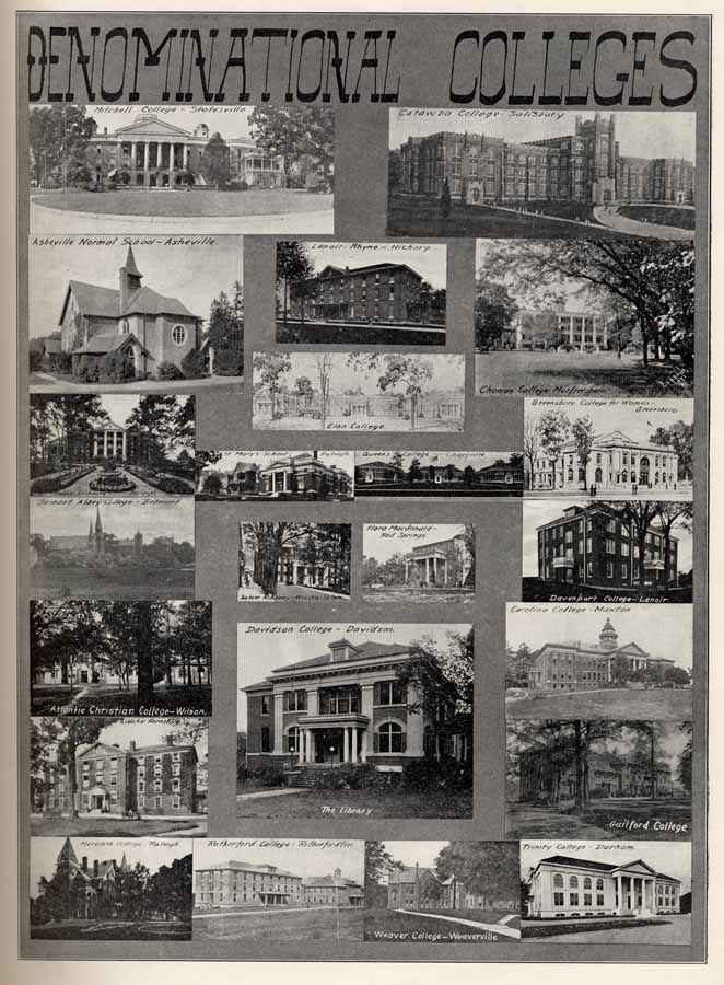
Demoninational Colleges


Page 10


Illustration

Highway Scenes


Page 11


Illustration

Highway Scenes


Page 12


Illustration

Products of the Farm


Page 13


Illustration

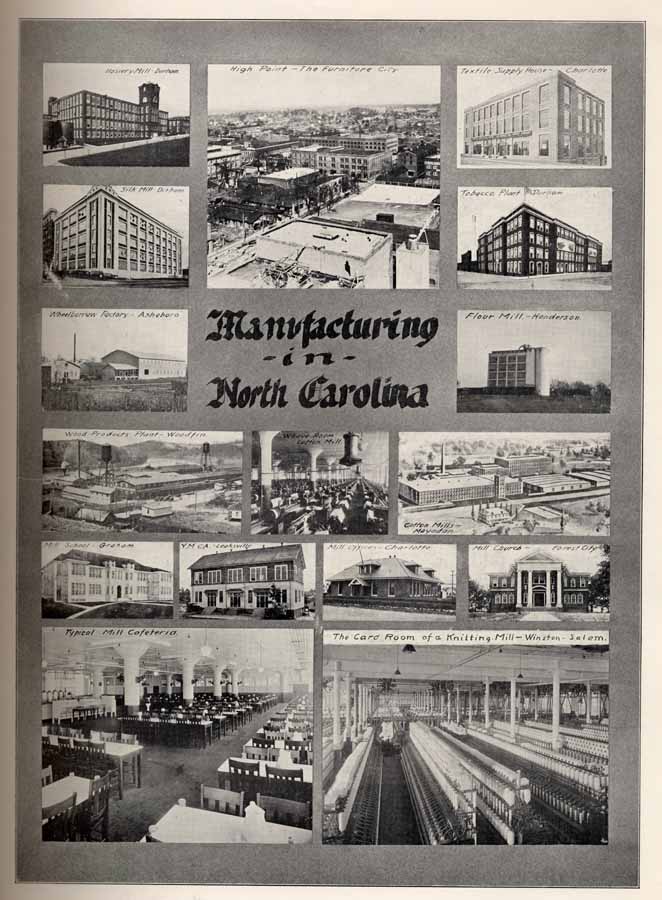
Manufacturing in North Carolina


Page 14


Illustration

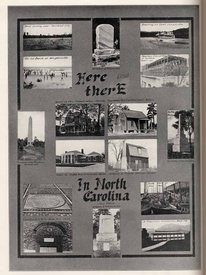
Here and There in North Carolina


Page 15


Illustration

Scenes from the Land of the Sky

HAIL TO THE HIGHLANDS


                         Hail to the Highlands of North Carolina!
                         Grandest of States let them ring with her name.
                         Where now the "willing" who dares to malign her?
                         Where now the country who knows not her fame?


                         Hail to the Highlands! The land of bright waters,
                         Land of the mountains, the cliff and the dell.
                         Health to her sons, long life to her daughters!
                         Peace to the homes where the mountaineers dwell!


                         Hail to the Highlands! How fruitful their valleys,
                         Boundless their forests, and priceless their ores!
                         Healthful the zephyr that over them dallies,
                         Swept from the glen where the cataract roars.


                         Hail to the Highlands! Upon them is dawning.
                         Light that will fill them with wealth and with power.
                         What of the noontide, if this be the morning?
                         What will the fruit be if this is the flower?


Page 16


Illustration

Western N. C. Lakes


Page 17


Illustration

Western N. C. Rivers


Page 18


Illustration

Western Carolina Waterfalls


Page 19


Illustration

Western Carolina Mountain Views.


Page 20


Illustration

Piedmont Carolina Scenic Gems


Page 21


Illustration

Piedmont Carolina Scenic Gems


Page 22


Illustration

Eastern Carolina Choice Scenes


Page 23


Illustration

Eastern Carolina Gems


Page 24


Illustration

EASTERN CAROLINA


Page 25


Illustration

RESORT HOTELS OF THE STATE


Page 26

Albemarle

Stanly County

ALBEMARLE-- "The Hub of Stanly County"

LOCATION--

        Albemarle, the County Seat of Stanly County, is situated in the central part of North Carolina. Albemarle is 123 miles southwest of Raleigh, 46 miles east of Charlotte and 86 miles south of Greensboro.

RAILROADS--

        The Winston-Salem Southbound and the Southern Railways serve the city. The former operates through sleepers from Roanoke, Va., to Jacksonville, Florida, in connection with the Norfolk and Western and the Atlantic Coast Line. The Southern, by connections at Salisbury, gives, the city direct access to all leading Northern and Southern markets. The Raleigh-Charlotte branch of the Norfolk Southern crosses the Southern part of Stanly County with direct connections at Raleigh for Norfolk.

HIGHWAYS--

        Albemarle is the hub of the Stanly County Highway system. 150 miles of the famous Stanly County shale highways have already been constructed while an additional 50 miles is now under construction, making a total of 200 miles of county road costing about $1,000,000.00. Two fine top-soil roads built by State and Federal aid, are the Charlotte-Albemarle-Raleigh capital highway, and the Salisbury-Albemarle-Wadesboro highway. Two large concrete bridges have been constructed at a cost of over $200,000.00, one of which connects Stanly with Anson County while the other joins Stanly and Montgomery Counties. The County highways are splendidly maintained by the Stanly County Highway Commission.

INDUSTRIES--

        Albemarle has two of the largest textile manufacturing plants in the State, with a paid-in capital of $5,000,000.00 who operate 160,000 spindles. Over 4500 operatives are employed with an annual payroll of over $2,000,000.00. Albemarle has two large knitting mills with several hundred employees, and large cash payrolls also. A large flour and feed mill in the city has a capacity of grinding 250,000 bushels of grain annually. Other industries include a cold storage plant, a large ice factory with 30 tons daily capacity, and three large lumber plants and woodworking establishments. The total amount invested in manufacturing and power in Albemarle and Badin is approximately $18,000,000.00 with annual payroll of over $3,000,000.00. (Badin is one of Stanly's aggressive towns.)

FINANCE--

        Albemarle has one National Bank and two State Banks with combined resources of approximately $2,000,000.00. There are also six rural banks in the county with total resources of over $450,000.00. Albemarle has two Building and Loan Associations, one of which carries over 10,000 shares.

FACTS--

        Albemarle has a splendid telephone exchange capable of serving 1000 subscribers, and it reaches to all parts of the county. Albemarle has an up-to-date water, sewer and light system costing $300,000.00. A new concrete dam and reservoir have recently been completed at a cost of $200,000.00, which will supply the city's needs for years to come. Albemarle gets her electric power and lights from the Southern Power Company who has a trunk line running through the city, direct from Great Falls, S. C. The city has $500,000.00 worth of bitulithic paved streets already completed with $200,000.00 worth of new paving under way. The city has an up-to-date fire-fighting equipment with a new $12,500.00 fire truck, and enjoys low insurance rates. A new $125,000.00 hotel has just been completed. There are two other hotels.

OPPORTUNITY--

        Albemarle is a city of prosperity, of industries, excellent retail and wholesale houses, of fine streets, beautiful residences and offers to the newcomer the things that mean success in any line. The County offers that fine climate that makes for health and happiness on rich farms or in the exploitation of her varied resources. Inquiries are welcomed.

        Every part of Stanly County is traversed by its famous shale highway system. One of the largest shale brick plants in the South is located here, making brick that are in demand all over the United States.


Illustration

Efird Cotton Mills
One of Albemarle's Hotels
A Bridge near Albemarle
One of Albemarle's Churches


Page 27

Population 10,000
1920--2,691

STANLY COUNTY--"The Land of Opportunity"

POPULATION--

        Albemarle is the county seat. It has a population of approximately 10,000 including the immediate suburbs. Stanly County has a population of over 30,000. The value of taxable property in Stanly County is $30,000,000 and the tax rate is $1.00 per hundred.

EDUCATION--

        Stanly County is very young in educational development, yet great progress has been made in recent years. Albemarle has an accredited High School with over 750 pupils and is a fully recognized High School. Excellent schools are located in the towns of Badin, Norwood, and Oakboro and at Wiscassett and Efird Mills. There are nine consolidated schools, all offering grade and high school work to about 6,000 pupils. Three years ago there were only four small rural schools, while today there are five brick and four wooden buildings. Eighteen trucks transport the pupils to and from school. The Mecklenburg Presbytery maintains a Normal School at Albemarle. The Mission Board of the Methodist Church maintains an accredited high school in the upper part of the county. A $60,000.00 brick building has just been completed for this school.

RELIGION--

        Albemarle has four fine brick churches belonging to the Presbyterian, Lutheran, Baptist and Methodist denominations.

AGRICULTURE--

        Stanly County annually produces over 10,000 bales of cotton and 1,000,000 bushels of grain, besides hay, fruit, poultry, lumber, cross ties, truck crops and other crops which net cash returns. Stanly is known as a great clover county. Its soil is especially adapted to the growing of red top clover. Stanly County wheat took first prize at the Paris Exposition. The farms are worked by their owners who are 90% native born.

MINERALS--

        Hundreds of thousands of dollars' worth of gold have been mined in Stanly County, and the largest single nugget of gold ever found in the South was found near Albemarle and netted $3000 when coined. The county is also famous for its mineral springs. Rocky River Springs and Misenheimer White Sulphur Springs are the most famous in the county. There are springs of iron, sulphur, arsenic, and magnesia--all at Rocky River Springs.

BRICK--

        Stanly County has one of the largest shale brick plants in the South. These brick have a wonderful reputation and are being used all over America. This plant cost $150,000.00 and is only the beginning of this industry, as the shale is here in unlimited quantities.

POWER--

        Stanly County ranks high in water power resources. At present 150,000 horsepower is already developed at Badin with an additional 150,000 horse-power available. Other developments are now being planned.

BADIN--

        Badin, "The Aluminum City," is in Stanly County just five miles east of Albemarle. Badin has the largest aluminum manufacturing plant in the United States. Over $12,000,000.00 has been invested at Badin; 1000 of the 3000 population are employed in the plant and receive hundreds of thousands of dollars annually in payrolls. Badin has the highest and largest concrete dam in the United States--210 feet high, 18 feet across the top, and 3700 feet long.

EWHARRIE PARK--

        A 2000 acre tract of mountain and forest land six miles from Albemarle has been made into a park. Morrow Mountain rises 500 feet above the Pee Dee River in the centre of this area. From the Pinnacle over 2000 square miles of some of the prettiest panoramic mountain forest and river scenery in the South can be seen, including views of the Pee Dee, Ewharrie and Yadkin Rivers and Badin Lake, all within a few minutes' ride.

        The total amount invested in manufacturing and power plants in Albemarle and Badin is between fifteen and eighteen million dollars. 150,000 H. P. is already developed while an additional 150,000 H. P. is available.


Illustration

Badin Dam 210 ft. high.
Railway across Badin Lake.
Badin Lake.
Bird's eye view of Morrows Mountain Mountain View Park, Albemarle, N.C.


Page 28

Asheboro

Randolph County

ASHEBORO--"In the Heart of North Carolina"

LOCATION--

        Asheboro is in the foothills of the Alleghany Mountains in the very heart of North Carolina. It is in the center of the State, as the exact geographical center is not far distant. Asheboro is the County Seat of Randolph County, situated in the very heart of the County. Randolph County is bordered by Guilford County on the north, Alamance and Chatham Counties on the east, Moore and Montgomery Counties on the south, and Davidson County on the west.

RAILWAYS--

        Asheboro is located on two railways. It is the Southern terminus of the High Point, Randleman, Asheboro and Southern branch of the Southern Railway, and at High Point, 28 miles away, direct connection is made with the numerous trains of the double-tracked main line of the Southern from Washington to Atlanta. Washington is 330 miles from Asheboro, Atlanta 373 miles, and Raleigh the State Capital is only 125 miles by rail. Asheboro is also the northern treminus of the Norfolk-Southern which runs south to Aberdeen 65 miles away, connecting there with the Seaboard Air Line main lines, Richmond to Tamps, and Norfolk to Birmingham. At Star, 23 miles south, connection is made with the main line of the Norfolk-Southern, running from Norfolk through Raleigh to Charlotte. Over 2500 cars of freight originate in Asheboro annually, being distributed all over America and to foreign countries. There are ten passenger trains in and out of the city daily. The County is also served by the Atlantic and Yadkin Railway from Sanford to Mt. Airy.

HIGHWAYS--

        Asheboro has long been a highway center. It was founded at the crossing of two great roads. One of these ran from Raleigh to Salisbury and Charlotte, while the other was the famous plank road which ran from Fayetteville, at the head of navigation on the Cape Fear, over 100 miles to Salem, the distributing point of the northwest. Today Asheboro still boasts good highways being on four branches of the State system. No. 62 runs from Asheboro to the Virginia line, No. 70 connects Reidsville, Greensboro, Asheboro, Pinehurst, Aberdeen, and Lumberton while No. 75 runs from Lenoir through Statesville, Salisbury, Lexington, Osheboro, Durham and Oxford and on to Virginia. No. 77 is hard surfaced from Asheboro through High Point to Winston-Salem.

CLIMATE--

        Asheboro has an elevation of 900 feet and enjoys a mild equable climate the year round. There is very little humidity, which makes the air always clear and pure. Asheboro nestles in the foothills with several low-lying ranges of mountains in sight of the city.

SCHOOLS--

        Asheboro has one of the finest and best directed schools in the State where a thorough course of instruction is offered covering eleven years, including High School work. A commodious brick High School cares for the needs of the city.

CHURCHES--

        Asheboro's religious life is centered in the churches of the leading denominations. There are seven church edifices. These churches maintain a fine moral and religious atmosphere throughout the city.

        Randolph County land is very fertile, raising corn, cotton, wheat, cowpeas, oats, rye, sweet potatoes and tobacco. The raising of hogs, horses, mules, sheep and cattle is proving very profitable, netting large incomes every year.


Illustration

Home Building and Material Co.
Asheboro Wheelbarrow Co.
Central Hotel
Court House


Page 29

Population 4,000

1920--2,559

RANDOLPH--"Banner Wheat County of the State"

AGRICULTURE--

        Randolph County's many agricultural products find an outlet through Asheboro, the County Seat. Randolph has for many years been the banner county of the whole State in the production of wheat, and today still maintains her leadership. The farm lands are fertile and well cultivated, and grow a wide variety of crops. Wheat, corn, cotton, cowpeas, oats, rye, sweet potatoes and tobacco are the leading crops. Within the past few years great interest has arisen in raising live stock, cattle and hogs. This has proven very profitable every year. With this diversity of crops and farm products the Randolph farmer is free from the inconveniences of a "one money crop" slump in prices.

INDUSTRY--

        Asheboro has over 12 manufacturing industries located in the city, among them being the Home Building and Material Co., the Asheboro Chair Co., the Randolph Chair Co., the Cranford Chair Co., and the Standard Chair Co., Asheboro Wheelbarrow Co., Asheboro Coffin and Casket Co., Acme Hosiery Mills, Asheboro Hosiery Mills, Dreamland Mattress Co., Asheboro Mills, and the Southern Crown Milling Co. The Home Building and Material Co., manufactures lumber from the stump to the finished product, and has a capacity for two complete houses a day. They specialize on schools and residences. The Randolph Chair Co., was organized in 1898 and makes a line of double cane seat chairs and porch rockers which are equal to any manufactured in the United States. The Asheboro Wheelbarrow Co. is the only wheelbarrow factory in the State, while there are only two others in the South. Besides covering the United States an export business has recently been opened. A branch lumber plant is operated at Pittsboro, N. C. The Acme Hosiery Mills, of which D. B. McCrary is President, manufactures a large line of hosiery which is sold over a wide territory. A large plant is operated in the heart of Asheboro.

HOTELS--

        Asheboro's hotels are: the Central and the Ashlyn. The Central Hotel has 40 rooms, is operated on the American plan and caters to both commercial men and tourists.

CITY FACTS--

        Asheboro boasts an excellent water and sewerage system. The system was installed to meet the needs of the city for years to come. The fire department is well equipped with modern appliances. Asheboro has an up-to-date light and power plant and has a fine telephone service, not only in the city but throughout the county.

FINANCES--

        Asheboro has three banks: The First National Bank, the Asheboro Bank and Trust Co., and the Bank of Randolph. The First National Bank has a capital and surplus of $100,000 and deposits of $665,735.

OPPORTUNITY--

        Asheboro, with her splendid location in the heart of the State, her mild climate and her native citizenship, offers the newcomer many inducements for the location of manufacturing industries. The Chamber of Commerce is ready to serve you.

        Asheboro has thirteen manufacturing plants. They are: 4 chair factories, 2 lumber manufacturing plants, 2 hosiery mills, 2 flour mills, 1 wheelbarrow plant, 1 coffin plant and 1 mattress factory.


Illustration

Acme Hosiery Mills.
Asheboro School
First National Bank
Randolph Chair Factory


Page 30

Asheville

Buncombe County

ASHEVILLE--"In the Heart of the Blue Ridge"

LOCATION--

        The Asheville Plateau, high up in the mountains of the Blue Ridge where the skies are as blue as turquoise and the air is as sweet as the odor of violets, is the setting of the mountain metropolis called Asheville, North Carolina. The city is in Buncombe County, one of the most attractive sub-divisions of the State, located on the Southern Railway System and interlaced by miles and miles of the best highways in Dixie. The Asheville district is noted for its climate, beautiful scenery, and great potential resources, the larger portion of which lie undeveloped right at the doors of railway lines and mountain rivers. Minerals abound throughout the great Western North Carolina territory, of which Asheville is the logical commercial and industrial center; while the rivers, many of which are now unharnessed, represent millions of kilowatts in hydroelectric water power as yet undeveloped. The water power projects, of which there are several under way and some completed, show the great possibilities of the mountain district in respect to future development along this line. In addition, there is a great deal of farm land in Buncombe County suitable for cultivation, and a considerable portion that is already producing the varied crops of the higher altitudes. Dairying and cattle raising are important industries which are growing rapidly and promise great future benefit to all entering these lines.

RAILWAYS--

        The city is at the junction of the Cincinnati-Columbia division, Murphy Branch, and Washington-Salisbury division of the Southern Railway, only 120 miles from Knoxville, Tenn., on the western main line of the Southern and 70 miles from Spartanburg, S. C., on the eastern double-track main line of the Southern. The Carolina, Clinchfield and Ohio Railway taps the western mountain district and furnishes connection with the Southern leading into the Asheville district. Besides steam railways, motor bus lines connect Asheville with Charlotte and many centers in the western part of the State, thus supplementing transportation to nearby places.

HIGHWAYS--

        Buncombe County has more miles of paved roads than any county in the South and this highway system joins the main roads of surrounding counties with main arteries running in all directions. When the present paving program of the municipality in completed, it will give Asheville a greater area of paved streets than any other city in the United States of 35,000 inhabitants. The city and county are on the eastern branch of the Dixie Highway, giving direct connection with all the Central States in the North, and with Georgia, Florida and the Gulf and South Atlantic States in the South. This highway is being rapidly developed, not only in North Carolina, but in all the states it traverses. The Dixie Highway is a popular route for Northern tourists who find it ideal as a main highway to Florida. To the west of Asheville a main artery highway leads through the western counties adjacent to the district and connects at Murphy with the Atlantic Highway. To the east, two main highways extend across the State, crossing the main counties of Eastern North Carolina and offering access to the chief coastal cities on the Atlantic Seaboard.

TRADING AREA--

        With its splendid railway and highway system the city is the center of a trading area of 25 counties in Western North Carolina. As a result the city is expanding as never before, new industries are springing up and inquiries are pouring in concerning the potential resources of the area. Building broke all past records the first half of the year, yet the building program cannot keep pace with population increase. From 1910-1920 the population increased 51 per cent and at the present apparent growth a new record will likely be shown by the 1930 census.

        Within 100 miles around Asheville are 64 peaks 6000 ft. and upward; 23 of them higher than Mt. Washington. Mt. Mitchell, 6,711 ft., "Monarch of the East," is the highest peak east of the Mississippi. The finest and most unique tourist hotel in the world is Grove Park Inn.


Illustration

Pack Square.
Asheville Country Club & Golf Course. Asheville, N. C.
Biltmore House, home of Mrs. Geo. W. Vanderbilt, Asheville, N. C.
Bear [illegible] ols Near Asheville, N. C.


Page 31

Population 35,000

1920--28,504

ASHEVILLE--"In the Land of the Sky"

SCENERY--

        Probably nowhere else in the world, and certainly nowhere in the United States is there such an extent of mountain valleys, rivers and brooks in one given spot as there is around Asheville, included in what is known as Western North Carolina. Nature was lavish in her wealth in this respect when she began the creation of "The Land of the Sky." Just around Asheville, within the confines of a circular area one hundred miles in circumference, there are some mountain peaks each a mile high, while sixty-four of them tower 6000 feet into the air, while Mt. Mitchell, King of them all, is 6,711 feet in altitude. All of these peaks are within easy reach of Asheville. Mt. Mitchell and Mt. Pisgah, the latter within clear view of the city, are places of unusual interest to the tourists who annually throng the countryside because excellent motor roads run almost to the top of these great pinnacles of earth, rock, trees and flowers. Sparkling streams race through valleys and gorges, tumbling over precipices in cascades and lovely falls throughout the mountainous country, while the tree foliage has been pronounced the most varied to be found anywhere in this hemisphere. From the sides and tops of the mountains one views the magnificence of Nature in all her most glorious moods, ever changing vistas presenting themselves to the eye wherever one may chance to look.

CLIMATE--

        Next to scenery, the climate of Asheville and surrounding country is one of the greatest attractions to thousands of visitors who come to the mountains for recreation, and also to other thousands who come once and remain to make their homes midst the enchanting hills and valleys. Scenery and climate, together with excellent transportation facilities, make this country a natural playground for the South, the East and the Middle West. Asheville's climate is unique in its distinctions and holds high favor in popular estimation. Its southern latitude tempers the rigors of winter, and because of its high altitude, 2,250 feet above sea level, the oppressive summer temperatures of the lowlands are unknown. The warmest month of the year is usually July, with an average temperature of 71.7 degrees, and the coldest month, February, usually has a mean temperature of 38.1 degrees. The mean temperature of the winter months varies only slightly from month to month, and one of the most cheerful aspects of the winter weather is that when cold does rule, it never penetrates like the cold dampness of the lower altitudes. The highest mean temperature that the weather bureau in Asheville has ever recorded was 74.1 degrees in August, 1906, and the lowest mean temperature was 28.8 degrees in January, 1918. The rainfall is never excessive and the greater part of the year is full of sunshine. As a whole, the climate is pleasant and invigorating, and makes Asheville an ideal all-year-round resort.

AGRICULTURE--

        The soil of Buncombe County holds forth great opportunities for the industrious farmer, and particularly the producer of garden truck. The outlook for the fruit grower is excellent and the apple industry is just developing. The soil grows corn, Irish potatoes, wheat, rye, oats, sorghum cane, cabbage and numerous vegetables of all kinds.

OPPORTUNITY--

        Truly Asheville is "the City of Opportunity" of Western North Carolina, because of her natural advantages of climate and location. Asheville is in the very midst of a vast region of undeveloped water power, minerals, forestry, farm lands, cattle raising and dairying. Asheville is annually attracting a larger number of tourists, many of whom remain permanently.

        Asheville facts: Summer Normal School, third year, 1923, had over 1000 in attendance. The largest Mica products manufacturing plant in America, largest furniture factory in the South, and one of the five largest white quilt mills in America, are in Asheville.


Illustration

Central High School
One of Asheville's Schools
West Asheville School
Biltmore Ave. School


Page 32

Beaufort
Carteret County

BEAUFORT--"The City by the Sea"

LOCATION--

        Beaufort is located on the Southern shore of Carteret County about midway between the eastern and western extremities of the County. Beaufort is nearer the Atlantic Ocean than any town or city in the State of North Carolina, having 2500 or more inhabitants. Carteret County is bordered on the south and east by numerous sounds which are separated from the Atlantic Ocean by narrow reefs which form two bays on the Atlantic side--Onslow Bay on the south, and Raleigh Bay on the east. Cape Lookout on the Atlantic is just twelve miles southeast of Beaufort. Carteret is bordered on the north by Pamlico Sound, the Neuse River, Craven County and Jones County, while the White Oak River forms the western border. Beaufort, itself, is almost completely surrounded by water. It is on a peninsular jutting into the waters of Core Sound on the east, Beaufort Harbor on the south, and Newport River on the west. On the north it is bounded by one of the most fertile sections of farming lands in the whole State.

PORT CITY--

        Beaufort is one of the best located Ports of the State. It is nearer the Atlantic Ocean than any other city of the State of over 2500 population. It is directly opposite Beaufort Inlet, less than a mile away. Its harbor, thus sheltered, is within easy access of all ships plying along the coast. Cape Lookout lighthouse is only twelve miles south of the city. Beaufort lies in 34 degrees north latitude and 76 degrees west longitude. It is in the extreme eastern part of North Carolina, Elizabeth City and Edenton being the only two cities in North Carolina of over 2500 population located further east.

RAILWAYS--

        The city of Beaufort is served by the Norfolk-Southern railway. This road runs due west from the city, across the Sound to Morehead City then turns north to New Bern, 38 miles away. The main line from Beaufort runs on through Kinston to Goldsboro. At Goldsboro direct connection is made with the Southern Railway to Raleigh, the State Capital, 146 miles from Beaufort, and to Greensboro, 227 miles away. At Goldsboro connection is also made with the Atlantic Coast Line from Wilmington to Wilson, Richmond, Washington and points North. Washington is only 379 miles from Beaufort. At New Bern connection is made to Norfolk, 208 miles away, over the Norfolk Southern Railway, and to Wilmington, 125 miles south over the New Bern-Wilmington branch of the Atlantic Coast Line. Four trains daily, two in each direction, give the city quick connection with both Northern and Southern markets. Fish and other seasonable products are exported quickly and safely to distribution points and markets.

BOATS--

        Naturally, a county bordering on so much water carries on a large commerce by means of boats. Beaufort has thousands of dollars invested in boats, with a number of freight, passenger and mail boats running regularly between the city and other points both far and near. Beaufort is the Southern terminal of the Boston-Beaufort Inland Waterway.

FACTS--

        Beaufort has just installed a sewer and water system which covers the whole town. It has paved sidewalks and is now paving the principal streets. A fine seawall lies in front of the town. The city owns her own water and electric plants. Beaufort has good public schools and a large private school. Baptist, Congregational, Methodist and Episcopal churches are here. Investigation of Beaufort's numerous advantages is welcomed by the Chamber of Commerce.

        Beaufort's fishing industry is one of the largest in the State. Approximately one million dollars is invested in boats, nets and factories. Lumber is also one of the big industries here.


Illustration

Court House
Inlet Inn
Methodist Church
Looking West on Ann Street


Page 33

Population 3,500
1920 -- 2,968

BEAUFORT--"The City of Gentle Breezes"

HIGHWAYS--

        State Highway No. 10 extends over 600 miles across the State from Murphy through Asheville, Hickory, Statesville, Salisbury, High Point, Greensboro, Durham, Raleigh, Goldsboro, Kinston, New Bern, and terminates at Beaufort. This is now being hardsurfaced. In addition, county roads bring all parts of the County into connection with Beaufort.

HISTORY--

        Beaufort is the County Seat of Carteret County and is one of the oldest towns in North Carolina. Carteret County was originally a part of the precinct of Bath which was one of the divisions of territory made by the Lords Proprietors soon after assuming control of the Carolinas in 1763. In 1722 Beaufort was made a Port of Entry and was incorporated the following year by the General Assembly. The first white settlers were French Hugenots in 1707 and these were followed by Swedes, Germans, English, Scotch and Irish. The present population is composed mostly of the decendants of these early settlers. The first court house was erected in 1728 and the first jail in 1736. The court house contains many interesting records of the early days of this community.

FISHERIES--

        The fishing industry in Beaufort is one of the largest in the State and furnishes employment to hundreds of people and approximately a million dollars is invested in boats, nets, factories and other equipment. The U.S. Government maintains an experimental station and laboratory on Pivers Island in the harbor.

INDUSTRIES--

        The lumber industry is a big one here and the largest mill in the County is located on the outskirts of the town. Besides the saw mills there is a barrel factory which supplies barrels to the potato growers and also makes fish boxes. There is also a knitting mill, an ice factory, and a canning factory in Beaufort. Opportunity is open for other factories here.

CLIMATE--

        Beaufort enjoys a remarkably pleasant climate, characterized by mildness in both winter and summer. This noted mildness is a natural result from the influences surrounding this location. It is nearer the Gulf Stream than any town in North Carolina, being only about fifty miles from this great ocean stream. Snow is a rare occurrence here and there is but little frost. Roses and flowers often bloom out of doors in January. The average winter temperature is 47.5 degrees; summer 78.4 degrees.

TOURISTS--

        The tourists who visit Beaufort in either summer or winter can always find somethings interesting to do. Trips to the ocean beaches, to Old Fort Macon, Cape Lookout, and into the back country are all of unusual interest. The sportsman can always get good fishing and in season there is good shooting. Bear, deer and foxes are fairly plentiful and there is an abundance of duck, goose and brant shooting in nearby rivers and sounds. There are several good hotels, restaurants and boarding houses which cater to tourists.

OPPORTUNITY--

        Beaufort offers excellent opportunity for the development of shipping facilities, and fishing activities. The farmer is welcomed to the rich lands of the county while the steadily increasing tourist trade offers great possibilities.

        Beaufort offers the tourist a mild climate both winter and summer, good hotels, excellent fishing all the year, bear, deer, fox hunting, an abundance of good duck, goose and brant shooting.


Illustration

Public School
Part of Business District
Pivers Island
Old Fort Macon


Page 34

Belmont
Gaston County

BELMONT--"Largest Town in East Gaston"

LOCATION

        Midway between Charlotte and Gastonia on "Manufacturers' Avenue," is situated the thriving town of Belmont. Located on the banks of the Catawba River, this town is in the midst of the great electrical power development of the Southern Power Company which operates enormous power plants on the Catawba River, both above and below Belmont. Belmont is situated in the eastern edge of Gaston County and has a large part in making Gaston County the fine yarn center of the entire South. Gaston County itself is bordered on the north by Lincoln County, on the east by Mecklenburg County, on the south by York County, South Carolina, and on the west by Cleveland County.

RAILWAYS--

        Belmont is one of the numerous towns of Piedmont North Carolina located on the double-tracked main line of the Southern Railway from Washington to Atlanta. Belmont is 391 miles from Washington and 256 miles from Atlanta By rail it is 185 miles southwest of Raleigh, the State Capital. Being on the main line of the Southern, all Northern and Southern markets are easily accessible for either passenger or freight. In addition to the excellent service of the Southern, the Piedmont and Northern Railway is a distinct asset to the town. This electric railway maintains a line from Charlotte to Gastonia and enters Belmont over a short line from Belmont Junction, some two miles away This railway operates 24 trains a day in and out of Belmont, making direct connection for both Charlotte and Gastonia. Belmont has a total of 31 passenger trains in and out every twenty-four hours.

HIGHWAYS--

        Belmont is on the National Highway from the North to the South, and the Wilmington-Charlotte-Asheville Highway which is now being hard-surfaced all the way from Wilmington to Asheville. The National Highway is now paved from Kings Mountain on the south to Greensboro on the north. Belmont has long enjoyed concrete roads both to Charlotte and Gastonia, so with this additional mileage paved, Belmont has easy access by motor to all parts of the state. A fine dirt road runs to Mount Holly.

BUS LINES--

        Every half hour during the day there is at least one motor bus passing through Belmont. There are two lines operating between Charlotte and Gastonia, connecting at either point for places beyond. A through line, Charlotte to Spartanburg, another from Charlotte to Asheville, and also one from Charlotte to Shelby, all pass through Belmont.

RELIGION--

        Several denominations maintain strong, well-equipped churches in Belmont. The Methodists have four, the Baptists three, the Presbyterians two, and the Lutherans one, making a total of ten churches of the Protestant faith. Belmont Abbey Cathedral is located on the outskirts of the town. This Cathedral is one of the largest and finest in the entire South. Belmont's religious and social life is centered in these houses of worship.

        Belmont has the largest group of cotton mills in the County, outside the County Capital. Gaston County is the fine yarn center of the entire South.


Illustration

Business Section
Imperial Yarn Mill
Chronicle Mills
St. Leo's for Boys.


Page 35

Population 5,000
1920 -- 2,941

BELMONT--"The Cotton Yarn Town"

COTTON MILLS--

        Twelve of the seventeen manufacturing plants of Belmont are cotton mills. These 12 plants have a total of over 175,000 producing spindles divided as listed below: The Climax Spinning Co., 21,760 spindles; the Stowe Spinning Co., 21,760 spindles; the Linford Mills, 16,320 spindles; the Perfection Mills, 16,300 spindles; the National Yarn Mills, 15,000 spindles; the Acme Mills, 13,300 spindles; the Crescent Mills, 13,056 spindles; the Sterling Mills, 13,056 spindles; the Imperial Yarn Mills, 13,000 spindles; the Majestic Spinning Co., 12,716 spindles; the Chronicle Yarn Mills, 10,000 spindles; and the Eagle Mills, with 10,000 spindles, making a grand total of 176,268 spindles.

OTHER INDUSTRY--

        Other industrial plants that are working for a bigger Belmont include: The Crowell Roller Mill, the Blue Ribbon Bakery, the Montbell Ice and Fuel Co., and the Belmont Printing Company, while one of the most important is the Continental Brick and Tile Co. Belmont is pre-eminently a town of industry and is the largest in the county with the exception of Gastonia, the County Seat.

FINANCES--

        The Bank of Belmont has kept pace with the growth of the town since its founding in 1910. Today it ranks as one of the large banks of the County, with $50,000 capital stock, surplus of $100,000 and total resources of over $2,147,000.00. Connected with this bank is the Belmont Building and Loan Association which has rendered a real service to Belmont in enabling the citizens to own their own homes.

EDUCATION--

        Belmont is proud of her well-equipped school system. The total amount now invested in schools in Belmont is $178,000.00. The Central School building cost $75,000; the East Belmont School was erected at a cost of $60,000, while the High School with its modern equipment cost $35,000. The colored school for Belmont is valued at $8,000. Belmont sends over 900 pupils to the white schools, with about 300 in the colored school. To teach this number there are 32 teachers for white children and five for colored.

PRIVATE SCHOOLS--

        Belmont is known far and near for her two splendid Catholic institutions of learning, the Belmont Abbey College for boys and the Sacred Heart Academy for girls. St. Leo's School for small boys maintained by the Sisters of Mercy is also located here. These schools are well equipped and situated in spacious grounds in the suburbs of town.

CITY FACTS--

        Belmont has a number of beautiful residences. These are made more attractive because of the well kept, paved streets and sidewalks on which they are located. All principal streets throughout town are paved. In 1920 the population was 2,941 or an increase of 153% over 1910. The estimate of today's population is 5,000 people.

        Belmont has twelve of the one hundred cotton mills of Gaston County. These mills operate a total of over one hundred and seventy-five thousand spindles.


Illustration

First Methodist Church
Belmont Schools
First Baptist Church
Presbyterian Church


Page 36

Burlington
Alamance County

BURLINGTON--"The City Substantial"

LOCATION--

        Burlington, "the city substantial," is located in the very heart of Alamance County. The county is bounded by Guilford, Rockingham, Caswell, Orange, Chatham and Randolph Counties. Burlington and Alamance County are located in the heart of the Piedmont Plateau of Virginia, and the Carolinas about equidistant from the mountains to the sea. This section is noted for its climate, fertility of soil, and its ideal living conditions.

RAILWAYS--

        Burlington is served by the Greensboro-Goldsboro branch of the Southern Railway. Its ten passenger trains every twenty-four hours give the city excellent outlet and direct connections give it ready access to all leading markets. At Greensboro, only 21 miles west, direct connection is made with the main line of the Southern. Fast trains over this double tracked trunk line place Burlington within 17 hours of New York, 10 hours of Washington, and 11 hours of Atlanta. Burlington's manufacturing plants and shippers are furnished excellent freight and express service to all the leading centers of both the North and South.

HIGHWAYS--

        Burlington is on several State routes in addition to having excellent highways which radiate to all parts of the county. Burlington is on State Highway No. 10 which runs from Beaufor to Murphy, about 600 miles across the State. Burlington is about one-third the distance from Beaufort to Murphy. Splendid bus service is maintained between the city and Greensboro, and also between Burlington and Durham. At either of these two points connections are made with busses to various points farther away.

MANUFACTURING--

        Burlington has forty cotton and hosiery mills and eight miscellaneous plants, with over $8,000,000 invested in manufacturing. 24,000,000 yards of gingham and 8,000,000 pairs of hose are manufactured annually. To the prospective manufacturer Burlington offers exceptional opportunities. The city has a plentiful supply of good all-American labor, reasonable rates on hydro-electric power, and numerous other attractive features which appeal to employers of both men and women.

AGRICULTURE--

        Dairy products and poultry are important factors in trade, because of excellent market facilities at Burlington. The city has three tobacco warehouses and two flour mills. Corn, wheat, tobacco, dairy and poultry products are the principal ones of the county. The annual revenue produced from agriculture in Alamance equals that produced from manufactured products. Thus, agriculture is one of the chief industries of the county.

FINANCE--

        Burlington's financial institutions are under the management of men long experienced in finance and developing, ready to give you sound, intelligent advice. These four banks have resources that make them amply able to care for the city's needs. Their total resources are over $12,000,000.

HOTELS--

        Burlington's hotel facilities will be amply increased by the erection of a new hotel now under way. Construction of this handsome new $30,000.00 hotel will add much needed facilities to the present overcrowded hotel accommodations in Burlington. The hotel is being built by the public spirited citizens of Burlington.

        Burlington has forty cotton and hosiery mills and eight miscellaneous plants with over ten millions invested in manufacturing, and a weekly payroll of eighty-five thousand dollars. Annual output is 24,000,000 yards gingham and 8,000,000 pairs of hose.


Illustration

May Hosiery Mills
Graded School
One of the City's Churches
Whitehead Hosiery Mills


Page 37

Population 10,000
1920 -- 5,952

ALAMANCE--"The Pioneer Manufacturing County"

HOMES--

        Burlington has an unusually large percentage per capita home-ownership, it being about 70 per cent, and the pronounced spirit of progress and prosperity that is being displayed in the building of new homes is obvious to the stranger immediately upon his arrival in Burlington.

EDUCATION--

        Schools are always asked about by parents coming to a new town. Burlington has a fine system of schools, well equipped and with faculties trained to handle youth in a competent way. Burlington is proud of her school system.

RELIGION--

        Burlington has a number of fine churches, all the leading denominations being represented in the city. They are practical exponents of the great precepts of Christianity. Their buildings reflect not only the general prosperity of the city, but the numerical strength of their congregation as well. They are well attended and their pulpits filled by able men.

CIVIC--

        Burlington is a city with vision. It has fifteen miles of paved streets, thirty miles of concrete sidewalks, twenty miles of water main, and a modern LaFrance motor-driven fire truck, an excellent water supply, electric light and sewerage systems--all in keeping with the reputation Burlington has as a live and modern city.

FACTS--

        Burlington, however, has approximately 5000 people living in the mak-Burlington has a population of 8,861, according to the last count. Burlington, however, has approximately 8,000 people living in the suburbs, making a total population of 16,000. The elevation is 850 feet above sea level. The city has a modern hospital. Over $280,000 was spent in 1922 for municipal improvements. One daily and two weekly newspapers, three building and loan associations, modern co-operative creamery, weekly industrial payroll of about $75,000.00, and hydro-electric power at low cost, are assets to the city.

N. C. RAILROAD--

        Alamance County was the scene of the first meeting held in North Carolina to discuss the construction of a railroad. The idea was to build from Morehead to the mountains and use mules for motive power. When the State in 1848 decided to build a steam line from Goldsboro to Charlotte the Whigs favored it, while the Democrats opposed it. The President of the Senate, a Democrat, broke the tie vote in that body by voting in favor of it. This ruined his political career but opened a door of hope to the Western counties. The North Carolina Railroad shops were located at Burlington.

HISTORICAL--

        Alamance County started the Revolutionary War and the first battle of the war--The Battle of Alamance (May 16, 1771)--was fought there and not at at Lexington. A long time afterward the county started the cotton mill business and wove the first colored cotton goods made south of the Potomac River. The first "dye house" for coloring cotton yarns was built in this county.

CLIMATE--

        The climate of Burlington and Alamance is even-tempered, mild, dry and healthful--the same climate that has made the Piedmont area so famous.

OPPORTUNITY--

        Burlington invites the inspection by others of her splendid opportunities and advantages to the manufacturer, homeseeker and homebuilder.

        Alamance County, one of the South's pioneer textile centers, combines agriculture and industry to such an extent that it is estimated that the value of agricultural products equals the value of those manufactured, amounting to millions annually.


Illustration

Part of the Business District
Burlington's New Hotel
Municipal Building
Burlington Coffin Plant


Page 38

Canton
Haywood County

CANTON--"The Industrial Town of Western Carolina"

LOCATION--

        Situated in this almost unmatched mountain region of the South, "The Land of the Sky" in Western North Carolina, is Canton, just an hour's ride from Asheville, the metropolis of this western mountain area. Nestling snugly between two beautiful mountain ranges in the valley of the Pigeon River near its head waters, Canton enjoys an excellent all-year climate and many natural advantages that assure its continual industrial development. Canton is in the eastern part of Haywood County, 11 miles from Waynesville the County Seat. Haywood County is bounded by Cocke County, Tennessee, on the north; by Madison and Buncombe Counties on the east, by Transylvania County on the South, and by Jackson and Swain Counties on the west.

RAILWAYS--

        Canton is on the Murphy branch of the Southern Railway, 18 miles west of Asheville where direct connection is made for through trains to New York, Washington, Raleigh--the State Capital, Goldsboro, Charleston, S. C., Cincinnati, Ohio, and St. Louis. In addition, the Tennessee and North Carolina Railway runs from West Canton to Spence, N. C., 17 miles south.

HIGHWAYS--

        Canton is located on State Highway No. 10, which runs from Murphy on the west, and extends through Asheville, Salisbury, Greensboro, Durham, Raleigh, Goldsboro, and on east to the Atlantic Ocean at Beaufort. At Asheville Highways Nos. 20 and 29 are tapped. No. 20 runs from Hot Springs, near the Tennessee line, through Asheville to Charlotte and Wilmington, while No. 29 runs from the Tennessee line through Mars Hill, Asheville and Hendersonville and on to the South Carolina line above Greenville, S. C.

TOURISTS--

        Every year thousands of tourists pass through Canton. Canton is in the midst of the tourist resort section of Western Carolina. Asheville is 18 miles east, while the Methodist Summer Assembly Grounds at Lake Junaluska are only 10 miles west, with Waynesville two miles beyond the latter. A splendid bus service of luxurious motor busses is furnished Canton, either to Waynesville, Lake Junaluska, or Asheville. While primarily an industrial town, Canton's tourist business is a distinct asset to the life of the town. Canton's hotel, the Imperial, is always full to capacity. Canton is annually attracting a large number of tourists.

INDUSTRY--

        Canton is primarily an industrial town. The plant of the Champion Fibre Company located here, is one of the largest paper mills in the entire United States. (Special mention is made of this plant on the following page.) Other industries are being attracted to Canton, while at present two new industries deserve mention. They are the Crescent Knitting Mills, and the Royal Clothing Manufacturing Company. A very popular brand of overalls sold all over the South, is made by this company.

FINANCES--

        The Bank of Canton and the Champion Bank & Trust Company are great factors in the business life of the city. These institutions are amply able to care for the financial needs of Canton.

        Canton is the industrial town of Western North Carolina. The largest Tannic Acid plant in the world and largest paper mill in the South are located here.


Illustration

The Road to Asheville
A nearby Scene
The Mountains in Winter
The Campion Bank & Trust Co.


Page 39

Population 3,500
1920 - 2,584

CANTON--"The Paper Town of the South"

PAPER MANUFACTURING--

        Throughout the entire South there is no plant similar to that of the Champion Fibre Company at Canton. In the extensive plant of this company are employed all three of the known processes for making paper. They are the soda, the sulphite, and the sulphate. Daily this plant turns out 375 tons of such material and also a variety of by-products for which ready distribution is assured to all parts of the world. Daily more than 37,000,000 gallons of water are consumed. It is thoroughly filtered to remove all impurities. Electrically driven pumps are used for fire protection and a steady pressure is insured by the location on a nearby hill of a large storage basin. More than 600 tons of coal are used daily and all exhaust steam is utilized in the evaporating processes. The Black Diamond Coal mines with a daily output of 1200 tons are operated by the company at Coal Creek, Tenn. The normal supply of wood on hand at the plant for pulp making purposes is 75,000 cords, 60 to 75 carloads arriving daily. The company owns and controls over 125,000 acres of timber lands in Western North Carolina, 60 per cent of which is hardwood. This area is a reserve supply to supplement purchases from farmers within a 250-mile radius who find a ready market for both cord wood and lumber at the plant. At present the company operates two band mills, one at Waynesville, the other at Smokemont, with daily capacity of 75,000 feet. Only the low grade woods are used for pulp making, thus enabling the company to sell over 15,000,000 feet of high grade lumber annually. In order to cut, mill and market all this timber, over 70 miles of railway are owned by the company, and several miles of flumes. Over 1000 men are engaged in these operations.

PRODUCTS--

        Nothing is wasted at this plant. As the exhaust steam from the boilers and engines is used for heating and evaporating, even the wood serves a double purpose. The largest tannic-acid plant in the world is located here, over 500 barrels of liquid chestnut wood extract being produced daily. The "spent" wood is then used for pulp-making purposes. Pine wood furnishes turpentine before making pulp. "Bindex," an extract for use in cores for foundry castings, and for dust settling on roads and floors is made. A complete electrolytic plant produces bleach to be used in pulp and paper making and renders a by-product of 10 tons of caustic soda daily, which is distributed to textile mills operating bleacheries in this Country. A paper plant with 50 tons daily capacity produces kraft, wrapping, sulphite bond, book and fine bristol and post card board papers. About one-sixth of the pulp made at Canton is made into paper there. The Company's engineering department does all construction work at Canton. Over 40 miles of railway siding serve the plant at Canton which has its own engines and cars. Over 1500 men are engaged in the operation of this plant and a splendid Y. M. C. A. is provided for their use. A new school building with all modern equipment is a recent development. Even from the above sketch, little idea of the enormity of this plant can be grasped, for it ranks as one of the really great enterprises of America.

OPPORTUNITY--

        Canton offers the manufacturer many natural advantages of location, climate and labor, and new industries are welcome. Investigation is invited.

        Canton is the home of the Champion Fibre Co., one of the really great enterprises of America, employing all three processes of paper making.


Illustration

Offices of the Campion Fibre Co.
Part of the Plant-Champion Fibre Co.
Another View of the Plant.
Bank of Canton.


Page 40

Charlotte
Mecklenburg County

CHARLOTTE--"The Center of Southern Activity"

LOCATION--

        Charlotte is strategically located in the very heart of the two Carolinas. Surrounded by good roads, fine farming lands, hundreds of manufacturing plants, and large power developments, Charlotte is destined to become the leader of the South.

RAILWAYS--

        The Southern, Seaboard Air Line, Norfolk Southern, and Piedmont and Northern (Electric) Railway systems serve Charlotte. Over 100 trains enter and leave the city daily, radiating in eight directions. Headquarters of "Lines East" of the Southern Railway System are located in Charlotte. A new office building is being erected by the Southern to house the various offices.

HIGHWAYS--

        Hard-surfaced roads radiate from the city in six directions. The National Highway crosses the Wilmington-Charlotte-Asheville Highway here. Motor bus lines run from Charlotte with destinations Greensboro, Raleigh, Asheville, Winston-Salem, and Columbia and Spartanburg, S. C. Shorter lines run to Concord, Salisbury, Monroe, Gastonia, Shelby, Lincolnton and Statesville.

HISTORY--

        The outstanding historical event in Charlotte's past was the signing of the Mecklenburg Declaration of Independence on the City Square, May 20, 1775.

TRADE TERRITORY

        Within 50 miles of Charlotte over 550,000 people and over 2,000,000 in a 100-mile radius embrace the richest trading territory in the South. Charlotte is the pivot around which are located 770 textile mills, 185 cotton oil mills and 125 furniture factories.

DISTRIBUTING CENTER--

        That Charlotte is the commercial and distributing center of the Carolinas is fully demonstrated by the fact that more than 200 large corporations of National reputation handle practically their entire business in this territory through branch plants, offices or representatives located in Charlotte.

POWER--

        This city is the center of the biggest hydro-electric development in the United States--the total horsepower developed and in immediate prospect of development being nearly 600,000--and is the home of the Southern Power Company, the largest hydro-electric company in the Country.

TEXTILE SUPPLIES--

        Charlotte is the largest center in the South for textile machinery and equipment, practically all the large companies in the United States and England handling their entire business in the South through Charlotte offices and plants. In addition, a large amount of machinery and equipment for textile mills is manufactured in Charlotte.

WIRE CENTER--

        Charlotte is the wire center of the Carolinas. Headquarters and relay offices in this city handle all business in North and South Carolina for the Western Union Telegraph Company, the Postal Telegraph Company, and the Southern Bell Telephone and Telegraph Company.

BANKING--

        Charlotte is the largest banking center of the two Carolinas, having 14 bank and trust companies with total deposits of $30,000,000 and combined resources of $42,000,000. Three building and loan associations have combined resources of over $4,000,000.

INSURANCE--

        The Piedmont Fire Insurance Co., of Charlotte writes more business annually in the State, and has the largest net earned surplus of any North Carolina Fire Insurance Company.

        Charlotte is the center of the largest hydroelectric development in the United States, the textile center of the South, and the commercial and distributing center of the two Carolinas.


Illustration

Charlotte Manufacturing Co.
Textile Mill Supply Co.
Plant of the Southern Asbestos Manufacturing Company.
Brockmann's Book Store
Interior View.
Charlotte Marble & Granite Works.


Page 41

Population 62,000
1920 - 46,338

CHARLOTTE--"The Distributing Center of Carolina"

CITY FACTS--

        Charlotte has: 26 miles of paved streets, six hotels with a total of 793 rooms, also a new 12-story hotel just completed, commission form of Government, $1,000,000 annual revenue from taxation, 100 miles of cement sidewalks, five libraries with over 25,000 volumes, 125 miles of domestic and storm sewer, $1,500,000 water works system with daily pumping capacity of 10,000,000 gallons and reservoir capacity of 60,000,000 gallons. Modern motor equipped fire department with three stations; elaborate "white way" system, a very efficient street railway system with 37.4 miles of track. 5000 cars pass Independence Square daily. Six hospitals and sanatoriums. Complete Health Department.

EDUCATION--

        Charlotte has 21 public school buildings, 10,569 pupils and 261 teachers. Institutions of higher learning include Queens College (for young ladies), Boird's School for Boys, Charlotte University School (for boys), O'Donoghue Hall (parochial school), Brown's Business College, King's Business College, Southern Industrial Institute, and Biddle University (colored).

THE CENTER--

        Charlotte is one of the largest distributing points in the South for automobiles and accessories. One of the largest automobile tire manufacturing plants in the South is that of the McClaren Rubber Company at Charlotte. The annual output is valued at over $3,500,000. Charlotte is the Southern Market for dyestuffs--laboratories and offices being maintained here by the leading dye corporations of America. The city has the largest millinery jobbing and importing house in the Carolinas. Brockman's Book Store is one of the largest in the two Carolinas and conducts a large mail order business. Charlotte is one of the South's most important distributing centers for motion picture films, the annual business exceeding $2,600,000. Charlotte is the home of Efird's Department Stores, one of the largest chain store groups in the South. Belk's head store is also here.

MANUFACTURING--

        Charlotte has annual payrolls of over $12,000,000 from the 200 widely diversified manufacturing and industrial plants. Charlotte has three large cotton oil companies operating eleven mills with an annual output of $10,000,000. The Interstate Milling Company is the largest flour mill in the State, with a daily output of 1000 barrels. The Charlotte Wagon and Auto Company is the largest and best equipped plant for the manufacture of commercial truck bodies, painting and repairing in the South. The largest monumental plant in the two States is the Charlotte Marble and Granite works. The Southern Asbestos Company is one of the two largest asbestos manufacturing plants in the South. The Southern Engineering Company has a large plant for the fabrication of steel for steel frame buildings and bridges. The Charlotte Manufacturing Company manufactures card clothing and reeds and is the only plant in the South making card clothing. The Textile Supply Company carries a full line of everything in mill and factory supplies and was incorporated in 1898.

FORD PLANT--

        For years a branch of the Ford Motor Company located here has handled all the business for North and South Carolina and a part of Virginia, while recently Ford has purchased 75 acres in Charlotte to build a $2,000,000 assembling plant with a daily capacity of 400 Ford cars.

OPPORTUNITY--

        This city and territory offers unbounded opportunity in manufacturing, agriculture and mining. Equal opportunities are offered to mercantile establishments, insurance companies, distributors and business interests of every kind.

        Charlotte is the center of the most rapidly developing area in the world. 25 years ago there were 150 mills in a 100-mile radius. Today there are 750 with over 10,000,000 spindles.


Illustration

Plant of Interstate Milling Co.
Efird's.
Charlotte Wagon and Auto Works
Southern Engineering Company


Page 42

Concord
Cabarrus County

CONCORD--"The Capital of Cabarrus."

LOCATION--

        Concord, the metropolis and County Seat of Cabarrus County, is a hive of industry located in the midst of a rich agricultural country. Concord is in the very heart of the county and is the market center of the country. Cabarrus County was formed from Mecklenburg in 1792 and is bordered by Iredell and Rowan Counties on the north, Stanly County on the east and Mecklenburg County on the south and west. Cabarrus County is in the midst of the famous Piedmont Plateau of rich farm lands.

RAILWAYS--

        Concord is on the main line of the Southern Railway, which is double-tracked from Washington to Atlanta. It is 359 miles south of Washington and 289 miles north of Atlanta. The County is also traversed by the Norfolk Southern Railway running from Norfolk through Raleigh to Charlotte. The State Capital is about 140 miles northeast. These railroads give the city and county excellent passenger, express and freight service to all leading markets of both the north and the south.

HIGHWAYS--

        Concord is the hub of a splendid system of county highways and also has three branches of the State Highway System radiating to Albemarle, Charlotte and Greensboro. In the county there are 20 miles of asphalt road, 50 miles of gravel, 500 miles of graded road, 35 miles of state highway and 20 miles of national highway.

BUS LINES--

        Concord's splendid highway connections have been instrumental in giving the city excellent motor bus transportation to a number of nearby points, direct service being maintained to Greensboro, Salisbury, Kannapolis, Charlotte and Albemarle.

COUNTY--

        There are 35,000 people in Cabarrus County. Cabarrus has a $100,000 county home, $50,000 jail, a $200,000 court house, and a $0.95 per 100 tax rate on property valued at $40,000,000. Cabarrus has a County Highway Commission, full-time physician, bovine inspector, home demonstrator, county nurse, welfare officer, juvenile judge, public library, ten girls' clubs with 215 members, and six community clubs with 750 members.

CITY FACTS--

        Concord also has a Merchants Association, Merchants and Manufacturers Club. Country Club with golf course, Young Men's Christian Association, a live Chamber of Commerce, and a Rotary Club and Kiwanis Club, as well as an Elks Club and branches of leading fraternal orders. Concord's tax rate is $1.24 per $100 on property valued for taxation at $12,000,000.00. Concord has a $100,000 City Hall, electric plant, water system, street car line, telephone system, gas plant and fire department. Concord also has a new creamery and a new $50,000.00 theatre and has one of the largest county fairs in the state.

BANKING--

        Concord's three banks have a combined capital stock of $600,000.00, surplus and profits of $245,000.00, deposits of $4,705,813.50, and total resources of $5,869,985.38.

RELIGION--

        The following denominations maintain churches here: Baptist, Methodist. Presbyterian, Lutheran, Episcopal, German Reform, Associate Reformed, Methodist Protestant and Catholic.

NEWSPAPERS--

        The County has six newspapers. One daily, one semi-weekly and four weekly papers cover the city and county with local and world news.

        Cabarrus County has 20 cotton mills whose yearly output is valued at thirty million dollars. Cabarrus farms produce cotton, wheat, oats, hay, potatoes, fruits, poultry and live stock.


Illustration

New Baptist Church.
The New Cabarrus Bank
Presbyterian Church
The Cannon Mills Kannapolis
Concord Plant


Page 43

Population 12,000
1920 -- 9,903

CONCORD--"In the Heart of Industry and Agriculture"

INDUSTRIES--

        Concord has 17 manufacturing plants, while the county has over 60 plants. In the city and county there are 20 cotton mills. These employ 7,000 wage earners earning $5,000,000.00 a year. The cost of materials is $20,000,000.00, while the value of manufactured products is $30,000,000.00. These mills consume 25,000 horsepower. Other industries include an oil mill, bleacheries, ice plants, lumber plants, brick plant, roller mills, a foundry, gas plants, candy factories, a mattress factory, felt shoe factory, toy factory, 2 hosiery mills, a chair factory, and Southern Power Company.

MILL PRODUCTS--

        Cabarrus mills produce towels, ginghams, madras, yarns, tire fabrics, sheeting, hosiery, prints and similar lines. These products are produced by some twenty cotton mills and are valued at over $30,000,000.00 annually. Other manufactured products of the county include cotton seed oil and its by-products, ice, brick, lumber and builders supplies, candy, flour, feed, gas and iron goods and several other minor products.

EDUCATION--

        The city and county together employ 225 teachers with a total enrollment of 9,084, including both white and colored pupils. The city has just completed a new High School building at a cost of $225,000.00 and a new $35,000.00 colored school. In addition to graded and high schools there are five institutions of higher learning in the county. These are Stonewall Jackson Training School for Boys (State Institution), Sunderland Hall School, Mt. Amoena Seminary for Girls, Collegiate Institute for Boys, all for white pupils and Scotia College for colored women.

AGRICULTURE--

        Cabarrus County is primarily a center of agriculture, being in the midst of the famous Piedmont Plateau, noted for its fine farm lands and excellent crops. Cabarrus lands raise cotton, wheat, oats, potatoes, apples, peaches, hay and vegetables. Cabarrus potatoes are unusually large and fine and the county is one of the leaders in the production of this commodity. Poultry and live stock are raised throughout the county.

KANNAPOLIS--

        Kannapolis is one of the unique communities of Cabarrus County, and in fact, of the state. It is the home of the Cannon Manufacturing Company who operate the largest towel mills in the whole world. But this is not its only disinction. The town of Kannapolis built around the Cannon Mills and largely controlled by the mill company itself, lays claim to the distinction of being the largest unincorporated city in the world. It has a population of 7000 (1920). (Editor's note--A special article on Kannapolis will be found on page 138.)

HOTEL--

        Concord has a commercial hotel at present, but seeing the need for a larger and more modern hostelry, a new eight-story fire-proof hotel is now planned.

OPPORTUNITY--

        From the foregoing sketch of the past and present accomplishments of agriculture and industry in the city and county, some small idea of the greater possibilities along these lines may be gained. Write the Chamber of Commerce.

        The largest towel mills in the world are located in Cabarrus County at Kannapolis. This city with 7000 people, lays claim to being the largest unincorporated city in the world.


Illustration

Post Office
Cabarrus Co. Court House
Methodist Church
New High School


Page 44

Dunn
Harnett County

DUNN--"The Best Town Under the Sun."

LOCATION--

        Dunn is situated in the extreme eastern point of Harnett County. Harnett County itself is bordered by Wake County on the north, Johnston County on the east, Cumberland and Hoke Counties on the south, and Moore, Lee and Chatham Counties on the west. Dunn is the largest town in the county, having about 3000 people within her limits.

RAILWAYS--

        Dunn is on the main line of the Atlantic Coast Line Railway, 191 miles south of Richmond and 480 miles north of Jacksonville. It is 22 miles from Fayetteville and 53 miles south of Raleigh, the State Capital. Dunn is the southern terminus of the Durham and Southern running from Durham through Varina to Dunn. Harnett County is also served by the Norfolk Southern Railway, the Atlantic and Western Railway, and another branch of the Atlantic Coast Line. The Norfolk Southern runs from the main line at Varina through Lillington to Fayetteville, while the Atlantic and Western connects Lillington, the County Seat, with the Seaboard Air Line Railway at Sanford. The Wilmington-Fayetteville-Sanford branch of the Atlantic Coast line crosses the western part of the county. These roads, through their connections, give outlet for county products to all leading Northern and Southern markets.

HIGHWAYS--

        Dunn is well served by State Highways, being the crossing point of Nos. 22 and 60. No. 22 runs from Wilson to Fayetteville, while No. 60 runs from the Tennessee line near Boone, through Winston-Salem, Greensboro, Sanford, Dunn, and on to Wilmington. Highway No. 21 from Raleigh crosses No. 60 at Lillington and extends South through Fayetteville and Lumberton to the South Carolina line.

AGRICULTURE--

        Dunn farmers raise a large variety of crops, including cotton, tobacco, wheat, oats, corn, hay, apples, peaches, watermelons, cantaloupes, sweet potatoes and truck. Poultry, hogs and live stock are raised all over the County. Dunn farmers annually sell 50,000 bales of cotton, 2,000,000 pounds of tobacco, thousands of bushels of sweet potatoes, wheat, oats and corn. Thousands of tons of cotton seed, carloads of green corn, watermelons and cantaloupes, great quantities of apples, peaches, huckleberries, strawberries, dewberries and other small fruits, thousands of pounds of fresh and cured pork and hams, many pedigreed hogs for breeding purposes, pure bred poultry, thousands of creates of eggs, dairy products, truck of every description, peas and peavine hay and a list of other commodities are shipped every year from Dunn.

CITY FACTS--

        Dunn has artesian water pumped to all homes, complete sanitary sewerage system, ample hydro-electric power, five miles of asphalt paving, a motion-picture theatre and a modern theatre catering to road attractions, a public library, children's playground, two public park sites, two bathing pavilions, a Chamber of Commerce, a thirty-piece concert band, and a $60,000 agricultural fair plant.

        While Dunn depends primarily on agriculture for her prosperity, her 17 manufacturing plants greatly add to the wealth and resources of the community.


Illustration

Broad Street
One of Dunn's Residences
Lucknow Cotton Yard.
Municipal Building.


Page 45

Population 5,000
1920 - 2,805

DUNN--"In the Pine Belt of North Carolina."

INDUSTRIES--

        Dunn has a total of 17 manufacturing plants, among which are: a farm implement factory, a furniture factory, two large lumber mills, one hosiery mill, a cotton seed oil mill, two machine shops, a railroad repair shop, three monumental plants, a cornice factory, two metal working plants, an ice factory, two ice cream factories, a house furnishings factory and a cotton mill with 40,000 spindles.

BUSINESS HOUSE--

        Dunn also has a bakery, one newspaper, one printing plant, seven garages, two automobile paint and trimming plants, three wholesale gasoline and motor oil distributors, two plumbing concerns, two electrical contractors, one steam and one hand laundry, two beverage bottling plants, five farm stock dealers, fourteen dry goods and clothing stores, and thirty-seven retail grocers. Dunn is the trade center for 35,000 people.

BANKING--

        Dunn has two banks and a Building and Loan Association. The First National Bank has a capital of $50,000.00 with deposits of three-quarters of a million dollars, and resources of $900,000.00 The Commercial Bank has a capital stock of $30,000.00 with deposits of a half a million dollars. The Building and Loan Association has over 3500 shares now in force and has constructed 35 homes since its organization in 1922.

RELIGION--

        Dunn has seven churches for white people. The denominations represented include the Baptist, Methodist, Presbyterian, Disciples of Christ, Free Will Baptist, Primitive Baptist, and Catholic. There are also six churches for colored Christians.

EDUCATION--

        Hand in hand with the growth of Dunn came the increase in interest in education and provision for the training of the children of Dunn. Today Dunn has three fire-proof modern school buildings for white children. A large children's playground is a distinct asset to the recreation of Dunn's youth.

SPORTS--

        The forests and streams around Dunn abound in fish and game, offering much pleasure to the sportsman. Fox, racoon, o'possum and quail inhabit the forests around Dunn, making Dunn the mecca of many huntsmen.

COTTON MARKET--

        Dunn ranks as the largest cotton market of the state. The Dunn market covers two city blocks and handled 150,000 bales between 1917 and 1922 inclusive, or 25,000 bales a year. A fire-proof cotton warehouse is located here with a capacity of 12,000 bales. A large ginnery is operated here, which is one of the most complete in the state.

OPPORTUNITY--

        Dunn offers the manufacturer ample hydro-electric power, fire protection, low insurance rates, raw materials for cotton, cotton seed oil, tobacco, furniture, wood working, lumber, brick, vegetable canning and other factories. Dunn has experienced labor for textile, furniture and wood working plants. The Dunn Chamber of Commerce welcomes inquiry.

        Dunn ranks as the largest cotton market in the State, over 25,000 bales a year being sold here. Dunn also has a fire-proof warehouse of 12,000 bale capacity.


Illustration

Graded School
Devine St. M. E. Church
First Baptist Church.
First Nat. Bank and Street Scene


Page 46

Durham
Durham County

DURHAM--"Second Largest Industrial City in N. C."

LOCATION--

        Durham is situated in the south central part of Durham County and is bounded by Person County on the north, Granville and Wake Counties on the east, Chatham County on the south, and Orange County on the west. Durham is only 26 miles northwest of Raleigh, the State Capital. The County was established in 1881. Durham has an elevation of 406 feet above sea level and an area of 3.87 square miles. The city was incorporated April 10, 1869.

CLIMATE--

        Durham, being located on the edge of the Piedmont Plateau, is favored by a good mild climate at all seasons. With an annual mean summer temperature of 71.3 degrees, and a winter mean temperature of 48, extremes are avoided at all times. Durham's days are 62 per cent sunshine with 47.19 inches annual rainfall. The annual snowfall is 10 inches, with prevailing westerly winds.

RAILROADS--

        Durham has five lines of railroad branching in seven directions. They are: the Southern Railway. Seaboard Air Line Railway, the Norfolk and Western Railway, the Durham and Southern, and the Norfolk Southern Railway. Two lines of the Southern serve the city, one being the Greensboro-Goldsboro branch, and the other connecting at Keysville, Va., with the Danville-Richmond line. These connections with four of the South's large railway systems give the city excellent freight connection with all leading markets.

HEALTH--

        Durham's health department of 13 employes zealously guards the health of the city. In 1922 the death rate was only 10 to 1000 white people, while the birth rate was 30.7. Watts Hospital (white), one of the finest hospitals in the South, is valued at $1,250,000, with 102 beds and 17 physicians and 48 nurses. Lincoln Hospital (colored), is valued at $150,000 and has 100 beds, 8 physicians and 21 nurses.

HIGHWAYS--

        Durham is well served by State Highways, being on Nos. 75, 10 and 13, giving outlets in five directions. Both the National and Central Highways pass through the city. These are the principal routes North to South and East to West, respectively. The Greensboro-Raleigh Highway is already hard-surfaced, while the National Highway is in process of being paved.

BUS LINES--

        An important method of transportation in North Carolina is by Motor Bus, and Durham is greatly favored in this respect, having through service to Raleigh, Greensboro, Henderson and Oxford, Roxboro, Pittsboro and Asheboro, Chapel Hill, Siler City and Danville, Va.

GOVERNMENT--

        Durham has had the Council-Manager plan of government since May, 1921 and is well governed. Among the things of which the city is justly proud is the well equipped fire department with four stations and first-class fire insurance rating. Durham spends hundreds of thousands of dollars a year on her streets and is a well paved city. There are over 60 miles of sewer. Property valuation is $58,005,342, with a tax rate of $1.05 on the $100. The County tax rate is 92 cents.

        Durham is the home of Bull Durham and Duke's Mixture smoking tobacco, Piedmont, 111, Chesterfield, Sovereign and Sweet Caporal Cigarettes, and 25 other products.


Illustration

Durham Hosiery Mills
American Tobacco Co.
Holland Bros. Furniture Co.
Entrance Trinity College.
One of the Dormitories.


Page 47

Population 35,000
1920 -- 21,719

DURHAM--"The Educational Center"

POPULATION--

        The census of 1920 gave Durham 21,719, but by including certain adjoining sections which should be now a part of the city, the population of greater Durham is conservatively estimated at 35,000. It is proposed to include this area in the city limits. Only .09 per cent of the population are foreign-born whites, while 63.9 per cent are native whites with 35.2 per cent colored.

INDUSTRIES--

        Durham ranks as the second largest industrial city of the State, her output in manufactured products being valued at more than $80,000,000 annually. The Liggett-Myers Tobacco Company and the American Tobacco Company have produced such well known brands as Duke's Mixture and Bull Durham smoking tobaccos, and Piedmont, "111" (one eleven), Chesterfield, Sovereign and Sweet Caporal Cigarettes. It is also the home of the Durham Hosiery Mills, the largest manufacturers of hosiery in the world, and the Golden Belt Manufacturing Company, largest small bag manufacturers in the world. Other Durham products include Erwin and White Star sheetings and pillow cases, Glasgow Zephyrs ginghams, chambrays and cheviots, Virginia-Carolina fertilizers, Occoneechee, Peerless and Climax flours, silk shirtings and sports goods, blank books, castings, cigars, harness, ice, mattresses, brick, overalls, wagons, building materials, bread, and proprietary medicines.

BANKING--

        Durham has nine banks with combined capital and surplus of $2,709,000 with annual clearances of over $78,000,000.00, or $6,500,000 a month. The Fidelity is one of Durham's largest banks, while the First National Trust Co. has recently erected a new home to handle their growing business.

HOTELS--

        The Malbourne Hotel is Durham's popular commercial hotel. Durham also has the Lochmoor Hotel and a new million-dollar hotel project under way.

EDUCATION--

        Durham's public school system is the equal of any in the State. The Durham School of Music and the Southern Conservatory of Music are valued assets, while the Durham Business School is a fully accredited class "A" institution. Trinity College, a Methodist co-ordinate college for men and women, has a $4,500,000 plant and endowment with an enrollment of 930. The University of North Carolina located at Chapel Hill, twelve miles from Durham, has an enrollment of over 2000. The National Training School (colored), has an enrollment of over 225 pupils.

RETAIL--

        One of the city's representative retail establishments is the Holland Bros. Furniture Company located in the heart of the city. The Durham Public Service Company furnishes efficient electric and street car service for the city.

INSURANCE--

        The North Carolina Mutual Life Insurance Company is the largest colored insurance company in the world. This Company owns its own modern office building and is a credit to the race, as well as to the city.

OPPORTUNITY--

        On account of nearness to source of raw materials, cheap electric power and transportation facilities, Durham offers excellent opportunities for the location of industries. Write the Durham Chamber of Commerce.

        Durham is the home of the largest hosiery mills in the world, the largest small bag manufacturers in the world, and the largest colored life insurance company in the world.


Illustration

Building, Durham, N. C. Fidelity Bank
Malbourne Hotel
Durham Business College.
Durham Public Service Co.
N. C. Mutual Life Ins. Co.


Page 48

Edenton
Chowan County

EDENTON--"The City of a Million Diamonds"

LOCATION--

        Ex-Governor Bickett once called Edenton "the City of a Million Diamonds," and Edenton is just that. Situated on the very shore of the Albemarle Sound, the sunlight sparkles by day upon ever-tossing waves like myriads of little diamonds; while by night the moon gives a new lustre to the radiant wave drops. Edenton is located on the Southern border of Chowan County on Edenton Bay which is a part of the Albemarle Sound. Chowan County is bordered on the south by Albemarle Sound and Edenton Bay, on the west by the Chowan River, on the north by Gates County, and on the east by Perquimans County. It is in the extreme eastern end of North Carolina, near the Virginia line.

RAILWAYS--

        Edenton is on the main line of the Norfolk Southern from Norfolk to Raleigh, the State Capital, and Charlotte. It is 82 miles south of Norfolk and 161 miles northeast of Raleigh. It is also the southern terminus of the Edenton-Suffolk branch of the Norfolk Southern. Suffolk is 50 miles north and connection is made here for Richmond and the West. At Norfolk connection is made for the North. Connections to different parts of the south are made at Wilson, Raleigh and Charlotte. Just south of Edenton the Norfolk Southern runs straight across Albemarle Sound over a trestle 6.7 miles long. This is the longest bridge over navigable water in the world and has a draw-bridge in the center to allow boats to pass.

HIGHWAYS--

        Edenton is on the Coastal Highway which is the shortest route between the North and South. The Edenton Ferry makes three round trips a day between Edenton and Mackeys (only two round trips on Sundays) thus opening this road for tourist travel. This road is now being hard-surfaced all the way to the Virginia line via Hertford and Elizabeth City. The old stage-coach road, known for centuries as the Virginia road, is also being hard surfaced, thus giving the city two direct auto roads to the Virginia line. In addition, the County is spending over $300,000 for twenty miles of lateral roads, so that the County--being but 178 square miles--will shortly be a network of well-made roads, one of the best county systems in the state.

BOAT LINES--

        The Edenton-Mackeys Ferry connects Edenton and that section of the State with the south shore of Albemarle Sound and the rest of North Carolina. This ferry is the connecting link between the State Highway System and that part of it lying in the eastern extremity of the state. Three ferries connect Chowan and Bertie Counties, and several steamers navigate the rivers from Edenton. Of special note is the Norfolk-Baltimore and Carolina Line which makes two round trips every week with freight, making direct connection with boats for all Northern ports. The freight lines are quite an asset to Edenton shippers, especially the fishermen.

INDUSTRY--

        Edenton's fifteen industrial plants are all successfully operated entirely by local capital. They are: Edenton Cotton Mills, Edenton Peanut Co., Farmers Peanut Co., Edenton Knitting Mills, Eastern Cotton Oil Co., Edenton Ice and Cold Storage Co., M. G. Brown Lumber Co., Edenton Lumber Co., Brown Brothers Grist Mill, cotton gins, a woodworking plant, and three jobbing houses, distributors of Edenton's products.

FISHERIES--

        The importance of the fishing industry to this entire section is very great. Shad and herring fisheries stand out pre-eminently. A Government fish hatchery is maintained at Edenton.

FINANCE--

        The financial interests of Edenton are handled by the Bank of Edenton and the Citizens Bank who have combined resources of over $1,750,000.00. The Edenton Building and Loan Association has enabled many citizens to build their own homes, and is still active in building the city.

NEWS--

        Edenton and Chowan County are supplied with all the latest news by a daily newspaper published in Edenton. This paper is of great service to the County through its publication of market quotations and fluctuations. A weekly paper also supplies many rural communities with news.

        The soil of Chowan County is generally fertile. The chief crops are cotton, peanuts and corn. Tobacco can be profitably raised and is gaining in acreage. Most of the county is adaptable to truck farming.


Illustration

Edenton Cotton Mill
A Residential Street
Edenton Peanut Co.
Farmers Peanut Co.
Edenton Hosiery Mill


Page 49

Population 4,200
1920 -- 2,777

EDENTON--"The Little City on a Bay of Diamonds"

BEAUTY--

        Centuries make little difference in nature. This is what has blessed Edenton from earliest settlers' days to the present time, making it "The Little City on a Bay of Myriad Diamonds" where the sparkle of both winter and summer sun transforms the ten miles of Edenton bay into a glorious vision of "things not made by human hands."

HISTORY--

        Edenton can truly boast of an illustrious past, being the second oldest settlement in North Carolina, once the State Capital and the Port of Entry. Coupled with her history are the names of Rev. Daniel Earle, the fisherman-parson; Joseph Hewes, one of the signers of the Declaration of Independence; James Iredell; Governors Johnson and Eden, after whom the town was named. History also recounts the Edenton Tea Party where the ladies declared against British goods as long as the tax remained on tea. The resolutions of the vestry of St. Paul's Church on June 19, 1776, are firmly linked in the minds of many Americans as a page in the grand history of our Nation. These resolutions were enacted two weeks before the Mecklenburg Declaration and were commonly known as their "Declaration of Independence," and constituted the subscription of these people to the political "test" set forth in August, 1775, by the Provincial Congress in Hillsboro. The resolutions expressed "Allegiance to the king but a determination to resist to the fullest any imposition by Great Britain of any taxation assessed without due representation, and by the sacred ties of Virtue, Honor and Liberty to support the Continental and Provincial Congresses to the utmost of their power and ability." They were signed by the eleven vestrymen of St. Paul's Parish. In the accompanying pictures will be seen a few of these historic scenes that are now monuments of the past.

PROGRESS--

        The main thoroughfare of Edenton is 80 ft. wide and extends from Edenton Bay for a mile through the heart of the city, traversing both the business and residential sections. The city has over five miles of asphalt streets in the residential sections, which together with city owned electric power, light and artesian water wells and sewerage system, contribute to the happiness and health of the citizenship. The bonded indebtedness of the city is small. The tax rate in 1922 was $1.18½ per $100.00.

EDUCATION

        Edenton has a splendid system of public education and additions to the school building in the center of town are being pushed to take care of the rapidly increasing population. Two wings have been completed giving a 50 per cent. increase to meet future demands for space.

RELIGION--

        St. Paul's Church stands out as a feature of the past, dating back to 1701. The new Baptist Church is a handsome building and covers one-half of a city block. Other denominations represented in Edenton are: Presbyterian, Methodist and Catholic. Each of these congregations worships in its own church edifice.

CITIZENSHIP--

        Today Edenton stands four-square for progress, though she retains one feature which other cities might emulate--her citizens are of the natural Anglo-Saxon stock of their forefathers, with very little foreign blood within her borders. The people are home loving and contented, but are wide-awake to seize every opportunity to advance the best interests of the city.

CLUBS--

        Edenton has its organizations of both men and women whose object is to advance the social, religious, educational and recreational interests of their city.

OPPORTUNITY--

        One organization keenly interested in the general advancement of the city is the Chamber of Commerce. The Chowan County Chamber of Commerce serves both the city and the county. Any inquiry made of the Secretary of this organization will receive prompt and courteous attention.

        The fishing industry of Chowan County for shad and herring stands out pre-eminently as one of the great features of this section, and for this reason the U. S. Government maintains a fish hatchery at Edenton.


Illustration

Cupola House Erected in 1758 Bank of Edenton
Citizens Bank
Edenton Tea Party House Erected in 1776
Edenton School


Page 50

Elizabeth City
Pasquotank County

ELIZABETH CITY--"The Metropolis of Albemarle"

LOCATION--

        Elizabeth City is the metropolis of Albemarle section of North Carolina. It is ideally situated on the banks of the Pasquotank River on the eastern boundary of Pasquotank County. Elizabeth City is the County Seat and is 45 miles south of Norfolk, Va. Pasquotank County is bounded by Albemarle Sound to the south, Perquimans and Gates Counties to the west, and by Camden County to the north and east. The population of the city and its suburbs is approximately 12,000.

RAILROADS--

        Elizabeth City is on the main line of the Norfolk-Southern Railway system from Norfolk to Raleigh and Charlotte. It is 45 miles from Norfolk where direct connection is made with roads to the North, placing the city within 20 hours of the leading markets. Raleigh is 188 miles to the southwest; and from Raleigh, Wilson and Charlotte southern markets are easily reached. A branch of the Norfolk Southern runs from Elizabeth City to Beckford Junction where connection is made for Suffolk, Richmond and the West.

HIGHWAYS--

        Elizabeth City is on the Coastal Highway--the short route from the North to the South. This highway is in process of being hard-surfaced. In addition to 20 miles of hard-surface road to be built in the County by the State Highway Commission, Pasquotank County is now spending $750,000 on the construction of paved roads throughout the County. Already over 35 miles have been completed. These roads are linking one of the richest agricultural sections of the State with Elizabeth City, the Metropolis of Northeastern North Carolina.

WATER TRANSPORTATION--

        Regular daily boat service is maintained between Elizabeth City and Norfolk, which gives shippers the benefit of both coastwise and export trade.

AGRICULTURE--

        The agricultural territory adjacent to Elizabeth City is as fine as can be found in the United States. Three crops are grown annually. This year Elizabeth City shipped almost a million dollars' worth of Irish potatoes, 250 refrigerator cars of May peas, besides corn, spinach, radishes, red beets, soy beans, etc. This section is the home of the soy bean industry, and the soy beans grown here are being shipped all over the United States for seed purposes. Agriculture in Pasquotank County has taken on new life with the opening of paved highways to market at Elizabeth City.

CLIMATE--

        Elizabeth City's working conditions are ideal, the yearly average temperature being 60 degrees, with an annual rainfall of 45.55 inches.

INDUSTRIES--

        Elizabeth City has numerous diversified industrial plants, including lumber mills, a furniture factory, a cotton mill, hosiery mills, ship yards, machine shops, an iron foundry, an ice cream manufactory, a brick yard, a tent and awning manufactory, a flour and feed mill, fertilizer plants, a cement grave vault plant, soy bean harvester manufactories, barrel and basket factories and a meat packing plant. Elizabeth City manufactures more soy bean harvesters than any other city in the United States.

FINANCIAL--

        Elizabeth City has four banks, three white and one colored. These banks have a combined capital of $865,000.00; combined resources of $655,000 and combined deposits of $4,674,000.00. It also has the oldest Joint Stock Land Bank operated in either North Carolina or Virginia.

        With the ever-increasing agricultural and industrial development, Elizabeth City offers great opportunities to the Agriculturist, the Manufacturer and the Home Seeker. Investigate Elizabeth City's opportunities.


Illustration

Hinton Building
High School Building
Court House
Street Scene


Page 51

Population 12,000
1920 - 8,925

ELIZABETH CITY--"The Sportsman's Paradise"

HISTORY--

        The historic features of Elizabeth City and vicinity date back to the time of the early settlers. Elizabeth City is only forty-five miles from the birthplace of Virginia Dare, the first white child born in America.

FACTS--

        Elizabeth City has a community hospital, a motorized fire department, a municipal market, and a modern and efficient school system. The city has ten miles of paved streets and twenty-five miles of paved sidewalks. The city has recently voted bonds in the amount of $800,000.00 with which to erect its own light and power plant and water plant in order to meet the demand of the growing city for additional lights and water, and at the same time establish rates lower than at present prevailing. A modern sewerage system will also be installed by the city. Elizabeth City is planning these utilities plants so that they will suffice for the city for many years to come.

RELIGION--

        Elizabeth City has nine churches--many of them being handsome edifices. Most of the leading denominations have adherents in the city and many of the churches have strong congregations, while all have both Sunday Schools and young people's organizations connected with the work of the church.

FISH--

        Elizabeth City is North Carolina's largest food fish center. There are three reasons why this is true. The first is its proximity to the biggest fishing territory in the State. The second reason is that Elizabeth City is the nearest shipping point in North Carolina, to the big food fish markets of the North and East. Fish shipped from Elizabeth City reach the big markets several hours earlier than if shipped from any other North Carolina city. Six steamboats and over twelve motor craft operate regularly out of Elizabeth City, touching every point of the fishing territory and connecting with many smaller boats. Elizabeth City is fortunate in being a year-round fishing center. Located on fresh water, it gets plenty of carp, perch, catfish, pickerel, black bass, round robins, and many other varieties of edible fish, when salt water fish are out of season. However, the salt water fishing is the greatest part of the industry in this State. Elizabeth City's fishing territory extends about 100 miles south and at places is 30 miles wide. Her territory is approximately one-fourth of the fishing territory of the State. About 3000 people are engaged in the fishing industry in Elizabeth City's territory. In 1922 about 5,000,000 pounds of fish were shipped from the city and sold for over $500,000.00. The fish caught in these waters are: shad, herring, rock perch, jacks, trout, bluefish, spots, crackers, mackerel, black bass, carp, eel, catfish, pampano, pike, sheepshead, mullet, roundheads, hogfish, manny shad, round robins, red bass, porgies, blackfish, shrimp, oysters, clams, escallops, sea turtles and snappers. North Carolina shad is the favorite in all Northern markets.

SPORTS--

        Elizabeth City, with the surrounding country and waterways, is fast becoming a mecca for tourists. Every season any number of motor boats from Northern points may be seen in the harbors. These yachts take the route through Dismal Swamp to Florida and return, thus coming into the local harbor. This is the center of the finest wild duck and goose shooting in the United States, which makes the city the rallying point of Northern gunmen. Many tourists are now passing through Elizabeth City over the Coastal Highway, the short route from North to South.

OPPORTUNITIES--

        Elizabeth City has much to offer new industries, tourists, or prospective citizens. Communicate with the Elizabeth City Chamber of Commerce.

        The tourist will find the Elizabeth City section a region of historic and romantic interest; while the sportsman may have all the pleasures of the finest hunting and fishing grounds America affords.


Illustration

Community Hospital
Southern Hotel
Elizabeth City Water Front
One of Elizabeth City's Churches


Page 52

Fayetteville
Cumberland County

FAYETTEVILLE--"Here Abides an Historic People"

LOCATION--

        Fayetteville, the County Seat of Cumberland County, is located on the banks of the Cape Fear River, at the head of navigation, 115 miles from the coast. It is in the center of a large agricultural area which ranks high in the quantity and value of its products. The County has a population of 42,000 and this city is the trade and market center, not only for the county, but for people in adjoining counties.

RAILROADS--

        Fayetteville is on the main line of the Atlantic Coast Line Railway half-way between New York and Florida. The Wilmington-Fayetteville-Sanford branch of the Atlantic Coast Line also passes through the city, while the Columbia-Maxton-Fayetteville branch joins the main line at Fayetteville. The Norfolk Southern enters the city from the north, while the Aberdeen and Rockfish connects the city with the Seaboard, and the Virginia and Carolina Southern gives connection with Lumberton. Thus Fayetteville has railways radiating in eight directions. Hourly service to Fort Bragg is maintained by gasoline trolley car.

HIGHWAYS--

        State Highways radiate from the city in six directions, extending from Fayetteville to Wilmington, Whiteville, Lumberton and the South Carolina line, Laurinburg, Raleigh and Wilson.

BANKING--

        There are four prosperous banks in Fayetteville, with total resources of $4,784,753.41 and total deposits of $4,263,490.39 (figures issued Sept. 14, 1923, latest available). There are three strong Building and Loan Associations in the city assisting the citizens to build their own homes. Many homes have been built this way.

RELIGION--

        Fayetteville has adequate church facilities of all denominations, as follows: Presbyterian, Methodist, Baptist, Episcopal, Roman Catholic, Jewish, several churches of different denominations for colored people, and numerous church missions.

EDUCATION--

        Fayetteville has a fine system of public schools and an up-to-date, new $160,000 High School with a strong staff of instructors. Over $400,000 has been expended in the new building program just completed. The city is the home of a State Colored Normal School.

NEWSPAPERS--

        Fayetteville has one daily newspaper, the Fayetteville Observer, which was founded in 1817. It has the leased wires of the Associated Press. The Observer is alive to the needs and opportunities of the city and backs all civic moves. A weekly paper, the People's Advocate, enjoys a large circulation in this territory.

CIVIC CLUBS--

        Fayetteville has several live civic organizations, including the Rotary Club, Chamber of Commerce, and a very active Woman's Club and a Business and Professional Women's Club. The Elks Club and the Moose Club are strong fraternal organizations.

DISTRIBUTION--

        Owing to a fine network of excellent highways and railroads, Fayetteville is the center of distribution for this entire section of the State.

        Fayetteville is in the center of one of the richest agricultural sections of the State of North Carolina. It is also the distributing point for this large area.


Illustration

Old Market House
High School
Hay Street
New Hotel


Page 53

Population 12,500
1920 - 8,877

FAYETTEVILLE--"On the Banks of the Cape Fear"

POPULATION--

        Fayetteville, with an area of about six square miles, had 8,877 people within her border in 1920, while today it is estimated that within a radius of a mile and a half of the center of the city, there are at least 12,500 people. One of the city's largest and newest residential developments lies just outside the city. There are only one-tenth of one per cent of foreign born in the city.

GOVERNMENT--

        Fayetteville has a Mayor and a Board of Aldermen who are always alert to the needs of the city. The city has a well organized fire department, a thoroughly equipped gas plant, a complete health department and a sanitary inspector. Over 21 miles of sewerage pipe has been laid in the city. Fayetteville's streets are already well paved but the city has undertaken an additional paving program that will cost approximately $500,000 when complete.

WATER SUPPLY--

        The city consumes over 1,000,000 gallons of water daily. The elevation of this water from source of supply is 225 feet. A pressure of 125 pounds for pumping is maintained. A $400,000 extension program now under way will increase the miles of mains from 20 to 30 and the hydrants from 100 to 150, thus insuring adequate fire protection and an abundant supply of pure, healthy water.

BUILDING--

        Building permits for the year ending November 1, 1923, totaled $1,000,000. At present a new 95-room hotel is being erected at a cost of $400,000. A ten-story office and bank building is to be started at once. Homes all over the city are being erected as well as a number of stores.

INDUSTRIES--

        Fayetteville has a great number of diversified industries, manufacturing the following products: brick, boxes, silk, mill work, cotton goods, candy, flour, flooring, rug poles, veneer, gas, fertilizers, ginghams, cotton yarns, glove tubing, meal, ice cream, signs, ice, plows and cotton seed products.

AGRICULTURE--

        Surrounding Fayetteville are some of the most fertile lands of the State where cotton, tobacco and trucking are the principal crops. It is also in close proximity to the famous Sandhill fruit section of North Carolina. The character and quality of the soil directly surrounding the city makes it an ideal fruit growing country. Several large peach orchards have already been started and are progressing very favorably.

RECREATION--

        Fayetteville has several parks, theatres for both drama and moving pictures, a new country club, fraternal clubs, and is only one and a half hours' ride from Pinehurst.

HISTORY--

        Cumberland County was founded in 1734 and named for the Duke of Cumberland. In 1736 a settlement called "Campbellton" was located on the Cape Fear River near the mouth of Cross Creek. In 1778 these two became one town and in 1783 the name was changed to Fayetteville, this being the first town in the United States to so honor the Marquis de LaFayette. Until the Civil War it was the principal town in the State.

OPPORTUNITY--

        Fayetteville--a city of moderate living costs, contented labor available, quick transportation and numerous industrial sites, has much to offer the manufacturer as well as the farmer. Write the Chamber of Commerce.

        Fayetteville's industrial plants manufacture over twenty-five products which are distributed to all parts of the country. Fayetteville has much to offer the manufacturer.


Illustration

Huske Building.
Jackson Bros. Planing Mill
Hay Street M. E. Church
Cumberland County Court House


Page 54

Gastonia
Gaston County

GASTONIA--"The Textile Center"

LOCATION--

        Gastonia enjoys an ideal location, being situated in the midst of the famous Piedmont section of the Carolinas, just 399 miles South of Washington and 238 miles North of Atlanta on the double-tracked main line of the Southern Railway between these two points. At Gastonia connection is made with the Carolina and Northwestern Railway for Lenoir, 65 miles north and Chester, 45 miles south. Gastonia is the southern terminus of the North Carolina division of the Piedmont and Northern Railway, which connects this city with Charlotte, 25 miles northeast. The P. & N. is operated by electricity and runs 12 trains to and from the city each day. In addition, Gastonia has 16 steam trains daily carrying passengers.

HOSPITALS--

        Located near the city limits is the new State Orthopedic Hospital. This institution is taking care of the crippled children of the State who are of a sound mind. The Hospital has a splendid location on a knoll with a splendid view of the surrounding country before it. The Hospital is rendering the State of North Carolina a great service in restoring to service the bodies of its youthful citizens. In the city itself there are hospitals serving the city and the county.

HIGHWAYS--

        Gaston County is proud of her splendid highways. Asphalt or concrete roads radiate from the city, touching the county line at nine different points. Gastonia is located on both the National Highway and the Asheville-Charlotte-Wilmington Highway. The latter is now in process of being hard-surfaced throughout its entire length. Another branch of the State Highway System extends north from Gastonia to Lincolnton and Hickory, and on to Blowing Rock. The Charlotte-Chester-Columbia Highway turns south at Gastonia. Gaston County is the leader in highway construction and has a system of county highways equal to any in the State.

COUNTRY CLUB--

        The Gastonia Country Club is quite an important factor in the social life of the city and county. It is located some three miles to the east of the city and is reached by a splendid paved and sand-clay highway. The clubhouse is a handsome building recently erected in the midst of spacious grounds. Golf and many other sports are afforded here.

CITY VISION--

        Gastonia has vision. The city has 17 miles of asphaltic pavement, 45 miles of sand-clay paving, 25 miles of concrete sidewalks, and one of the most modern water and sewerage disposal plants in the South. Motorized fire apparatus has enabled the city to get a second-class insurance rating. The future is given thought in all contemplated improvements.

GASTON COUNTY--

        The County is located in the southern edge of North Carolina, bordered on the south by South Carolina; on the west by Cleveland County; on the north by Loncoln County and on the east by Mecklenburg County. Good farmng lands are found throughout the County. The following progressive towns add to the prosperity of the county: Belmont, Bessemer City, Cherryville, Cramerton, Dallas, Hardin, High Shoals, Lowell, McAdenville, Mt. Holly, and Stanly.

CLUBS--

        The city has Rotary, Kiwanis, Lion and Civitan Clubs. Each of these organizations is strong and active and a live factor in the growth of the city. The Woman's Club is also one of the best workers for the city's best welfare. The Chamber of Commerce maintains a complete organization in the city and is a leader in the commercial activity of Gastonia and is behind every forward movement for the betterment of the community.

OPPORTUNITIES--

        The Chamber of Commerce is active in promoting the development of both the city and county. Any inquiry about either will be gladly answered by the Secretary of the Gastonia Chamber of Commerce.

        Gaston County, with over one hundred cotton mills, is the premier in the whole South in textile manufacturing and one of the leaders in the entire nation in this line.


Illustration

View in Retail District
Central School
New City High School
One of the city's new Churches


Page 55

Population 21,000
1920 -- 12,871

GASTONIA--"The Spinning Center of the South"

THE CITY--

        Gastonia, the cotton spinning center of the South, is proved by the census to have enjoyed a phenomenal growth. The 1920 census gives the city a population of 12,871 but the increase since then, besides the industrial development in the suburbs, gives the city fully 21,000. The city has modern commission form of government, asphalt paved streets, splendid churches, excellent schools, attractive homes and the healthful climate for which the Piedmont country is noted. It is a city in which it is a pleasure for a progressive citizen to dwell.

MANUFACTURING--

        Gastonia is the County Seat of Gaston County, which ranks third in the world, outside of Great Britain, in producing spindles in operation and under construction, leading the States of the Union, except Massachusetts and Rhode Island. 44 of the 98 cotton mills in the County are located in Gastonia. Their capitalization totals $15,995,900.00. Products for 1922 totaled in value $31,618,366.00. The average daily payroll exceeds $15,000.00.

BUSINESS--

        Business conditions, in view of the large payrolls released weekly in cash by the industrial plants, are exceptional. The volume of business done by the local merchants enables them to keep the best stocks and to meet the prices of other cities much larger. Banking conditions are noteworthy. Gastonia has three National and two State banks which have been a strong factor in the development of the city's industries. Gastonia's mills have been developed and are owned by home capital with only one exception.

BUILDING AND LOAN--

        Building and Loan Associations, two in number, have aided to a notable extent in the past few years in the erection of hundreds of attractive homes, placing the possibility of owning a home within the reach of any provident person.

CHURCHES--

        Gastonia is a city of beautiful churches and all the leading denominations have strong representation and beautiful edifices. These churches have large and strong congregations.

FRATERNITIES--

        The fraternal spirit is strong in Gastonia. There are many of the leading secret orders represented with lodges of large membership. At present a beautiful Masonic Temple is in course of construction.

EDUCATION--

        Gastonia is proud of her schools. Her schools are first-class and the city takes pride in the fact that her teachers are paid higher salaries than those in any other city in North Carolina. This naturally means that she is enabled to have higher-class faculties in her schools. The city has ten schools with over 3000 pupils.

SUMMER CAMP--

        Gastonia does not forget her boys and girls. A splendid boys and girls camp is operated every summer at Rotary Park. This Park is located at the foot of Crowder's Mountain, some 6 miles from the city and is reached by paved highway. This camp is operated by the Gastonia Rotary Club. A public playground is also provided for the children in the heart of the city.

HOMES--

        Gastonia is a city of beautiful homes. Her streets are well shaded and well laid out, and many attractive homes have sprung into existance along these streets. Street car service is maintained between the city and some of the mills by the Piedmont and Northern Railway Co., who enter the city.

STATISTICS--

        Cotton mills, 98; Capital invested, $35,979,600; producing spindles, 1,130,675; looms, 3,646; weaving mills, 13; processing plants, 1; fine-combed yarn spindles, 845,827; operatives employed, 16,183; houses for operatives, 5,391; bales of cotton consumed, 212,500; bales consumed daily, 692; average daily payroll, $30,000; average sales per banking day, $187,101; gross sales for 1922, $57,440,246.

        Gastonia is the cotton yarn manufacturing center of the South. Gaston County ranks third in the whole world, outside of Great Britain, in the number of producing spindles.


Illustration

Country Club
Partial View of Loray Mills
A Gaston County Highway
State Orthopedic Hospital


Page 56

Goldsboro
Wayne County

GOLDSBORO--"The Gate City of Eastern N. C."

LOCATION--

        Located in the geographical center of Eastern North Carolina, Goldsboro is recognized as being the gateway to this large area of fertile lands. Goldsboro is in the center of Wayne County of which it is the County Seat. Wayne County is bordered by Wilson County on the north, Green and Lenoir Counties on the east, Duplin County on the south, and by Sampson and Johnston Counties on the west. Wayne is one of North Carolina's leading agricultural and manufacturing counties.

RAILROADS--

        Goldsboro's railway service makes her the gateway to a large part of this section. The city is the eastern terminus of the Southern Railway in the State. The "Carolina Special," one of the Southern's fast trains, runs between this city and Cincinnati, Ohio, via Raleigh, Greensboro, Winston-Salem, Asheville and Knoxville, Tenn. The Wilmington-Norfolk trains of the Atlantic Coast Line pass through the city and connect with the Richmond-Tampa main line of this system at Wilson, 24 miles north. A branch of the Norfolk-Southern System runs east from Goldsboro through Kinston and New Bern to Morehead City and Beaufort. A short branch of the Atlantic Coast Line connects at Smithfield, 23 miles west, with the main line. It is only one day's journey from Goldsboro to New York, Washington, Savannah, Jacksonville and Atlanta, and less than 30 hours to Boston, Montreal, Buffalo, Chicago, St. Louis, Memphis, New Orleans and Palm Beach. Goldsboro has thirty-two passenger trains daily.

HIGHWAYS--

        Goldsboro has ready access to the various points of Eastern Carolina through a splendid system of highways. State Highway No. 10 running from Murphy and Western Carolina to the coast at Beaufort passes through Goldsboro. State Highway No. 40 running from the Virginia line near Roanoke Rapids south to Wilmington, crosses No. 10 at Goldsboro, while No. 192 connects with No. 12 at Snow Hill. Wayne County Highways are in excellent condition and form an important addition to the system of State Highways extending from the city of Goldsboro.

BUS LINES--

        With the building of concrete or paved highways in Eastern Carolina the motor bus is gradually serving a larger and wider territory. At present Goldsboro has motor bus service to Raleigh, Wilson, Mount Olive and Kinston.

CITY FACTS--

        Goldsboro has the City Manager form of government, sixteen miles of hardsurfaced streets, twenty-eight miles of cement sidewalks, three hospitals, water, lights and gas to all sections of the city, a modern sewerage system, a modern apartment house, playgrounds, parks, permanent sanitary and health officers with efficient staffs, a permanent community center now erecting a modern community building, and a chapter of Associated Charities. Goldsboro's assessments for taxation are $16,500,000.00. The value of municipal property is $1,500,000.00. A $100,000.00 Post Office building has annual receipts of $50,000.00. The city tax rate is $1.42 per $100.00. Goldsboro enjoys low gas, water, telephone and electric power rates while living conditions, from a financial standpoint, compare favorably with other cities.

        Goldsboro has forty-two manufacturing plants producing brick, veneer, lumber, building supplies, cotton yarns, hosiery, tobacco, furniture, mattresses and farm implements.


Illustration

City Hall
Union Station
Street Scene
Court House.


Page 57

Population 15,000
1920 - 11,296

GOLDSBORO--"In the Heart of Wayne County."

POPULATION--

        In 1910 Goldsboro was still a small town with only 6,142 inhabitants but in ten years this nearly doubled, the city being given 11,216 by the 1920 census, while it is estimated that there are now 15,000 people here.

COMMERCE--

        The city is the shopping and trade center for about 100,000 people within a 20-mile radius. Goldsboro's importance as a commercial center is fast developing, as the city is the center of a vast agricultural area, the home of numerous industries and the distributing point for numerous commodities.

INDUSTRY--

        Forty-two manufacturing plants are located here, having a combined value of over $4,000,000.00 with an annual pay roll of $2,236,000.00 and an annual output valued at $6,125,000.00. The principal products manufactured are brick, veneer, lumber, building supplies, cotton yarns, hosiery, tobacco, farm implements, furniture, mattresses, ladies' and gents' ready-to-wear, and commodities. One of the larger manufacturers of lumber and its products is the Enterprise-Whiteville Lumber Co. The Empire Manufacturing Company makes veneers, boxes and cases for musical instruments, and have one of the largest plants of this kind in the South.

BANKING--

        Three banks, the Wayne National Bank, the National Bank of Goldsboro and the Peoples Bank and Trust Company, have total resources of $6,178,994.00. The Wayne National Bank has just completed a new 10-story bank and office building.

AGRICULTURE--

        Wayne County ranks as one of the foremost agricultural counties of the State. It produces annually 30,000 bales of cotton, and 15,000,000 pounds of tobacco. Other leading crops are grain, hay and other food crops. Live stock and poultry raising are annually gaining in importance.

SCHOOLS--CHURCHES--

        Goldsboro's school system includes nine buildings and a staff of competent instructors. There are over 3000 children in attendance. The Odd Fellows Home for orphan children is located in the city. There are sixteen churches in the city representing the leading denominations.

HEALTH--RECREATION--

        Pure water, a mild climate, and an excellent health department combine to make Goldsboro a city where health conditions are ideal. The death rate averages less than nine to a thousand. Playgrounds and parks add to the pleasure of the inhabitants, while the sea-coast resorts only a few hours away offer fine surf bathing.

RESIDENCES--

        Goldsboro has many beautiful residences, while the majority of the citizens own their own homes. One of the most recent residential developments is the beautiful Edgewood suburb on the eastern limits of the city. This property lies between the Odd Fellows Home and the Country Club about a mile from the center of the city.

CIVIC CLUBS--

        Goldsboro has a number of civic clubs, including the Chamber of Commerce, Merchants Associations, Rotary and Kiwanis Clubs, Woman's Club and leading fraternal orders.

OPPORTUNITIES--

        Goldsboro, rapidly becoming the commercial center of this rich area, welcomes the distributor as well as the manufacturer, while the home seeker will find low utility rates and the traveling salesman will appreciate the railway and highway facilities which make Goldsboro the gate city of Eastern Carolina.

        Wayne County is one of the leaders in agriculture in the State producing cotton, tobacco, peas, celery, strawberries, mellons, fruits, live stock, hay, alfalfa, vegetables and poultry.


Illustration

Enterprise-Whiteville Lumber Co. Office
Empire Manufacturing Co.
A Corner of Edgewood
One of Goldsboro's Parks


Page 58

Greensboro
Guilford County

GREENSBORO--"In the Industrial Zone of N.C."

LOCATION--

        Greensboro is located in the heart of North Carolina's amazing industrial zone. It is in the exact center of Guilford County, of which it is the County Seat. Guilford County is bordered on the north by Rockingham County, by Alamance County on the east, Randolph County on the south, and by Davidson and Forsyth Counties on the west.

RAILROADS--

        Greensboro is the hub of a fine system of railways reaching out in six directions. The city is on the main line of the Southern Railway which is double-tracked from Washington to Atlanta. It is 287 miles south of Washington and 361 miles north of Atlanta. The Greensboro-Goldsboro branch of the Southern runs east from the city, while the Southern also runs west to Winston-Salem and North Wilkesboro. The Sanford-Mt. Airy section of the old Atlantic and Yadkin Railway crosses the Southern main line here. Greensboro has through Pullman service to New York, New Orleans, Jacksonville, Birmingham, Cincinnati, St. Louis and other points.

HIGHWAYS--

        Guilford County's highway system centers in this city while State Highways radiate in six directions with their terminal points as follows: Murphy, Beaufort, Wilmington, Boone, Lumberton and Danville, Va.

STATISTICS--

        Statistics for 1923 show that the city had a population of 43,525 with an area of 16.9 square miles, or 10,816 acres; 67 miles of paved streets, $320,141.79 postal receipts, 607 retail stores, 5,600 telephones, 6,000 automobiles, 1,056 building permits amounting to $3,513,491, while the assessed valuation of the city was over $70,000,000.

BANKING--

        Greensboro's banks have a combined capital and surplus of $3,378,162; deposits of $20,926,223; combined resources of $22,309,811; while the 1923 bank clearings were $271,289,000.

GOVERNMENT--

        In 1921 all politics were eliminated and the city administration placed in the hands of capable business men. The system of assessment and taxation was straightened out and a City Manager employed. Today the tax rate is only $1.24 per $100 on $75,000,000 assessed valuation. There are 58 miles of sewers with a septic tank disposal system, and a new storage reservoir with a one-billion gallon capacity, has been constructed to complete the city's water supply. The city has arranged to build and lease to the Southern Railway a $1,000,000 union station. Green Street, parallel to Elm, has been widened to 80 feet, new fire stations built, while with all these improvements the bonded debt of the city is only $4,906,000, with the tax rate six cents less than it was six years ago.

CHURCHES--SCHOOLS--

        Greensboro has 56 churches, two libraries, a Y. W. C. A. building, 3 Y. M. C. A's. Over $1,000,000 has been expended in building new schools. There are four high schools (two new), and eight grammar schools, Greensboro College for Women, and North Carolina College for Women. The latter has 1300 students and 150 instructors. There are three colored grammar schools and three negro colleges.

HOTELS--

        The O. Henry is Greensboro's newest hotel and is one of the finest in the South. There are two others planned.

        The largest denim mills in the world are in Greensboro. Greensboro is the Insurance center of the South, with five life and five fire insurance companies located here.


Illustration

McGlamery Auto Company.
Wysong & Miles Company
Pilot Life and Trust Co. (trade mark--Pilot Mountain)
Home of El Rees-so Cigars.


Page 59

Population 48,000
1923 - 43,525

GREENSBORO--"Insurance Center of the South"

HISTORY--

        The famous Battle of Guilford Court House was fought six miles from the city. General Joseph E. Johnston disbanded his army in Greensboro after his surrender to Sherman. Jefferson Davis held the last meeting of his cabinet here. O. Henry (William S. Porter) was born here.

HEALTH--

        Greensboro's climate has none of the rigor of the North, yet lacks the languor of the far South. St. Leo's Hospital and the new Guilford County Tuberculosis Sanitarium are the two largest, while there are several smaller hospitals and private sanitariums. The Guilford County Home for the poor is a model of its kind.

AMUSEMENT--

        The National Theatre is one the finest and largest in the South and features good road shows and movies. In addition to the various theatres the city has league baseball and the Central Carolina Fair.

THE TRIANGLE--

        Greensboro is at the eastern point of the famous "Industrial Triangle" formed with Winston-Salem, the underwear and tobacco city; and High Point, the furniture city. In this triangle are 120,000 people, 323 factories with $126,000,000 capital invested. They produced in 1922 goods valued at $305,000,000--the largest production of any city or area of like size in the United States.

INSURANCE--

        Greensboro is the South's greatest insurance center. It is the Home Office and headquarters of five life and five fire insurance companies with combined capital of $2,700,000; income $13,000,000; surplus $444,115,000. The Jefferson Standard Life Insurance Company has recently completed a 17-story office building. The Pilot Life Insurance Company is another of Greensboro's strong companies. It was formerly the Southern Life and Trust Company.

INDUSTRY--

        Greensboro is a city of industry. Just a few of her many plants may be mentioned. Among these are Proximity and Revolution Cotton Mills. The Carolina Steel and Iron Co., who make a general line of structural steel for all purposes, and the El Rees-So Cigar Co., manufacturers of the famous El-Rees-So cigars. Over seven million a year are made and half of them are consumed in North Carolina. The Wysong & Miles Co. are manufacturers of wood-working machinery. The Newman Machinery Co. also makes a general line of woodworking machinery, including flooring and lath machinery, molders and saws. The McGlamery Auto Co. has one of the most up-to-date Ford distributing plants in the State.

DISTRIBUTION POINT--

        Greensboro has direct freight service and package car service to points throughout this section. Freight rates are so favorable to Greensboro that no city can compete with her in her native territory.

AGRICULTURE--

        While large quantities of truck, poultry and dairy products are raised here and shipped away, the demand still far exceeds the supply. Conditions are unusually favorable for raising these products and they net large returns.

OPPORTUNITY--

        Few sections of the State offer the tremendous possibilities of returns for the investment made as does Greensboro and Guilford County--not only in manufacture and agriculture, but in almost any line of endeavor. Write the Chamber of Commerce.

        The Jefferson Standard Life Insurance Company's office building, seventeen stories high, is one of the finest and most attractive office structures in the entire South.


Illustration

Newman Machine Works
National Theatre
Carolina Steel and Iron Plant
Guilford Co. Court House


Page 60

Greenville
Pitt County

GREENVILLE--"The Market for Pitt County"

LOCATION--

        Greenville is located in the heart of Pitt County on the southern bank of the Tar River about half-way between Tarboro and Washington. Pitt County is a part of the broad, eastern coastal plain of the State and is bordered by six counties as follows: Edgecombe and Martin Counties on the north, Beaufort County on the east, Craven County on the south, and by Lenoir, Wilson and Greene Counties on the west.

RAILWAYS--

        Pitt County is amply served by railways while Greenville itself has railway service in four directions. Greenville is on the main line of the Norfolk Southern Railway which runs southeast from Norfolk through Greenville to Raleigh, the State Capital, and on south to Charlotte. At Greenville this line is crossed by the Weldon-to-Kinston branch of the Atlantic Coast Line Railway. This line connects with the main line at Weldon giving Greenville direct passenger and freight connection with Richmond, Washington and New York. In addition to the above, Pitt County is crossed by the Rocky Mount-Parmele-Plymouth branch of the Atlantic Coast Line and by the Parmele-to-Washington branch of the same system. The East Carolina Railway from Tarboro through Farmville to Hookerton also crosses the county. Thus it is seen that almost every part of the county is directly served by a railroad, enabling Pitt county to transport all her products to leading markets very quickly.

HIGHWAYS--

        Greenville and Pitt County are equally well served by State Highways. No. 91 runs east from Raleigh through Wilson, Greenville, and Washington to Swanquarter. This route is crossed at Greenville by No. 11 which runs north from Keenansville through Kinston and Greenville to Parmele. No. 12 runs north from Snow Hill to Tarboro and passes through Pitt County, touching Farmville. No. 90, which runs east from Raleigh through Rocky Mount, Tarboro, Williamston and Plymouth to Columbia, and tips the upper part of the County at Bethel. In addition to these State routes there is a fine system of county roads. Including both State and county highways Pitt has a total of over 83.7 miles of improved roads.

CITY DATA--

        Greenville has many miles of well-shaded, paved streets flanked by concrete sidewalks. The city owns and operates its own water and light plants and has many miles of water main and a modern sewerage system extending throughout the city. Greenville has a well-equipped fire department. The Home Telephone and Telegraph Company is one of the city's efficient utility operators and has a modern telephone exchange building in the heart of the city. The Strand Theatre furnishes the city with amusement. The Daily Reflector is Greenville's newspaper, and enjoys a large circulation. A gas plant is now being installed. The city tax rate is $1.00, while the assessed valuation is $8,751,426.00.

COUNTRY CLUB--

        Greenville has a well-appointed Country Club located about 2 miles from the city on the banks of a beautiful lake. Opposite the club house there is a fine golf course furnishing excellent sport.

HOTELS--

        Greenville has two hotels, the Proctor and the Princeton. The Proctor is American Plan while the Princeton is European. These are both well-equipped and are distinct assets to the city.

ROTARY CLUB--

        The Greenville Rotary Club has erected a handsome club house with a modern gymnasium included. So far as can be learned, this is the only club house anywhere in the world erected and owned by Rotarians.

        Greenville is one of the leading bright-leaf tobacco markets of the State and over three-fourths of all tobacco sold here is shipped abroad. Greenville has over sixteen tobacco warehouses and over twenty manufacturing plants.


Illustration

High School
First National Bank
Telephone Building
Methodist Church


Page 61

Population 7,500
1920 -- 5,772

PITT--"The County of Diversified Crops"

POPULATION--

        In 1920 Greenville had a population of 5,772, while today it is about 7,500. Pitt County had a population of 45,569 in 1920. The white population was 22,544 and the colored was 23,025. The climate of Pitt County is so mild that outdoor life is enjoyed the year round. Hunting and fishing are favorite sports and are engaged in at all seasons.

EDUCATION--RELIGION--

        Greenville has an excellent system of public schools. There is a modern high school building and a well-equipped grammar school building. A $200,000 bond issue has been voted for new schools. A modern school is operated in connection with the East Carolina Teachers' College here. There are nine churches here representing the leading denominations.

COLLEGE--

        The East Carolina Teachers College is located at Greenville. This is one of the State institutions of higher learning and specializes in the great public school system of the State. The college has nine buildings in use at present while an extensive building program is now under way involving the expenditure of over $1,025,000. When these additional dormitories and other buildings are completed the college will have a capacity of over nine hundred students.

INDUSTRY--

        Greenville has a total of over 20 manufacturing plants including 5 bottling plants, 2 monument works, a buggy plant, a cotton mill, a hosiery mill, an ice plant, fertilizer works, florist, bakery and candy shop. The Flannagan Buggy Factory is Greenville's oldest and largest manufacturing plant. This company is also the Ford distributor here.

TOBACCO MARKET--

        Greenville is one of the largest bright-leaf tobacco markets in the State. There are over 16 large tobacco sales rooms and warehouses located in the city. Over three-fourths of all the tobacco sold on the Greenville market is shipped abroad--a large part of it going to China.

BANKING--

        Greenville has three banks which, with those of the county, have total capital, surplus and undivided profits of $1,108,277; deposits of $6,474,142, and resources of $8,298,333. The National Bank of Greenville is the largest with capital of $100,000, deposits of $1,163,855 and total resources of $1,343,271. These banks are well able to care for Greenville's needs.

HOSPITAL--

        The Pitt Community Hospital has recently been completed and has 42 beds and all modern equipment throughout. There are both white and colored departments. A new nurses' home adjoins it. The staff includes 12 physicians and 3 graduate nurses. The Hospital has a capital of $80,000.

AGRICULTURE--

        The soils of Pitt County are more varied than those of any other county in the Pamlico section, there being 11 different kinds here. They are peculiarly adapted to the growing of bright-leaf tobacco, cotton, corn, peanuts, Irish and sweet potatoes, velvet beans, soy beans, hay, grain crops, various fruit and truck crops and livestock. Pitt is one of the largest bright-leaf tobacco producing counties in the State, and ranks thirty-fifth out of the 50 leading counties in the United States in the value of all crops.

OPPORTUNITY--

        Greenville is just beginning a period of prosperity and progress never before equalled and invites the investigation of its advantages in manufacturing, agriculture or any other line of endeavor. Write the Greenville Chamber of Commerce.

        Pitt County has a greater variety of soils than any other county of the Pamlico Section. It is a leader in the State in the production of bright-leaf tobacco. Other crops include cotton, corn peanuts, potatoes, beans, fruits, truck and livestock.


Illustration

Proctor Hotel
East Carolina Teacher's College.
Court House
One of Greenville's Stores


Page 62

Hamlet
Richmond County

HAMLET-- The "Pivot Point" of the Carolinas

LOCATION--

        Hamlet is known as the "Pivot Point" because it is located in the exact center of the two Carolinas. It is a very important railway point, being the pivot point of eight branches of railway. Hamlet is in the Southeastern corner of Richmond County, which is on the southern boundary of North Carolina, about one-third of the way from the coast to the Tennessee line. The County is bounded by South Carolina on the South, Scotland County on the East, Montgomery and Moore Counties on the North, and is separated from Anson County on the West by the Yadkin River, and further down by the Great Pee Dee River after the junction of the Yadkin with Little Pee Dee. Hamlet is located in the very heart of both the peach and tobacco belts.

RAILROADS--

        Hamlet is recognized as a very important railway center. It is on the main line of the Seaboard Air Line from Richmond to Tampa; also on the main line of the Seaboard from Norfolk to Atlanta and Birmingham, and is also on the Wilmington-Charlotte-Rutherfordton branch of the Seaboard, while it is the northern terminus of the Hamlet-Charleston-Savannah branch of the Seaboard. The Rockingham Railway, which passes near the city, runs south to Bennettsville, S. C., where connection is made for both Florence and Sumter and the Atlantic Coast Line system. This places Hamlet in direct touch with each of the five South-Atlantic Seaports, having a direct line to each of the following ports: Norfolk, Wilmington, Charleston, Savannah and Jacksonville. The Seaboard Air Line Railway shops are located in Hamlet, as well as the Divisional Offices of that road. The Hamlet re-icing station is the largest plant of its kind in the South, and the contract has already been let for doubling its capacity in order to care for the large increases in shipping of fruits, and vegetables from this section. The Seaboard also maintains a large Transfer Station for handling their freight through this junction point. The payroll of the Seaboard here amounts to about $200,000 per month, or $2,400,000 a year.

HIGHWAYS--

        Hamlet is located on the Quebec-Miami Highway which connects the North with the South, and thousands of winter tourists pass Hamlet each season going to Florida. It is also on the Wilmington-Charlotte-Asheville Highway which is now being hard-surfaced throughout its entire length. These principal highways, together with numerous short intersecting roads, give Hamlet easy access to a trade territory of fifty miles radius, commanding a large part of the trade of a population of approximately three hundred and seventy-five thousand people.

CLIMATE--

        Hamlet is in the lower, or Southern part, of the celebrated Sandhill territory where the air drainage has a remarkable effect upon the climate. Thus Hamlet has a dry but very pleasant atmosphere throughout the entire year. The many sandhills throughout this section have the effect of giving mild winters. Even a hard rain fails to produce an unpleasant day, for within a few minutes after such a rain, golf and other outdoor sports may be enjoyed. The climate in this zone is largely responsible for the numerous winter tourist resorts located near Hamlet.

HOTELS--

        Hamlet has at present three Hotels -- the Terminal, the Seaboard, the Commercial, with a new one planned.

CLUBS--

        The Fraternal Organizations are represented by the Masonic Bodies, Junior Order American Mechanics and the various railway unions. The Women's Club is a live organization.

        The Seaboard Air Line Railway Shops and Divisional Officers are located here. The monthly payroll of the Seaboard in Hamlet averages about two-hundred thousand dollars. Hamlet is an important railroad center.


Illustration

Hamlet Avenue
Graded School.
Residence--Mrs. Lackey.
Presbyterian Church.


Page 63

Population 7,500
1920--3,808

HAMLET--The "Peach" Town

AGRICULTURE--

        Hamlet's chief industry is that of Agriculture. The city is in the very center of the peach belt that extends from Southren Pines, N. C., to Columbia, S. C. It is also in the midst of the tobacco belt which extends East and West for over a hundred miles. These two principal crops are supplemented by truck, berries and cotton. Poultry raising and dairying have also assumed considerable importance in this section. Hamlet is thus the center of a large producing country and is the market and shipping point for a large tonnage which goes to points throughout the East and South.

INDUSTRIES--

        Hamlet's industries include lumber and wood manufacturing by the following firms: W. R. Bonsal Constructing Co., Hamlet Manufacturing Co., and the Carolina Contracting Co. The Hamlet Sign Works makes electric and other type signs. The Buttercup Ice Cream Co. and the Hamlet Steam Bakery are distributors and make their own respective products.

FINANCE--

        The Bank of Hamlet and the Page Trust Co., are the principal banking houses and are fully able to meet the requirements in financing the needs of the city. These two banks have a combined capital of $125,000.00; combined surplus of $75,000.00, and combined deposits of $1,500,000.00.

PROGRESS--

        The city is run on the commission plan and the commissioners are soon to let the contract for a new City Hall to cost between fifty and seventy-five thousand dollars. This building is planned to care for the needs of a city of about twenty thousand population. A new Masonic Temple is to be started at a very early date. Plans are being drawn for the erection of a modern one hundred room fire-proof hotel to be located at "Three Points" at the upper edge of the business district and construction will be pushed, as the hotel is needed at once.

FACTS--

        Hamlet has a Chamber of Commerce, Kiwanis Club, and a Young Men's Business League. Richmond County has a Tobacco Development Association with an all-time expert Tobacco Agent at its head. The Richmond Farm Bureau of the County is also working for the farmers, making most liberal arrangements with those who move into the county, for either operating, renting or cropping. Hamlet has a well-equipped motor fire department and adequate police protection. The water system is excellent. The water is brought to the city from the many springs throughout the Sandhills, and gives the city an adequate supply. The city is supplied by electric power generated at Bluitt Falls, a few miles away.

RELIGION--EDUCATION--

        All leading denominations are represented here. The city has a splendid $100,000.00 Y. M. C. A., a Salvation Army and Boy Scouts. The schools are attended by over seventeen hundred pupils. A new $50,000.00 High School is a real asset to the school system.

HEALTH--

        The city has two hospitals--The Hamlet Hospital and the Moncure Hospital, both well equipped. On the outer edge of the city there are numerous lakes for fishing, bathing and boating.

OPPORTUNITY--

        The business men are ready always to welcome the stranger and newcomer. Information gladly furnished by the Chamber of Commerce, or the Richmond County Development Board.

        Hamlet's chief industry is agriculture. Hamlet is in the center of the Peach belt, and also in the heart of the Tobacco belt. Other crops are truck, berries and cotton, while poultry raising and dairying are gaining favor daily.


Illustration

Main Street
High School
Hamlet Hospital.
First Baptist Church.


Page 64

Henderson
Vance County

HENDERSON--"The City of Diversified Industries"

LOCATION--

        Henderson is located in the very heart of Vance county, which borders Virginia on the north, Granville County on the west, Franklin County to the South, and Warren County on the east. Henderson is located on good highways and has splendid railway service. It is about 140 miles inland, about halfway between the mountains and the sea, and high enough to avoid the low, swampy lands near the coast.

RAILROADS--

        Henderson is situated on the main line of the Seaboard Air Line Railway from Richmond to Tampa, and also on the Norfolk-Birmingham line of that railway. In addition, the Seaboard operates a line from Henderson to Durham, while the Southern Railway serves the city by a line from Henderson to Oxford, where connection is made for Durham to the South and to Keysville Virginia, to the North. At the former point the Greensboro-Goldsboro branch of the Southern is tapped, while the Danville--Richmond branch is connected with at Keysville. Henderson is 113 miles South of Richmond, 44 miles north of Raleigh, the State Capital, 738 miles north of Tampa, 632 miles from Birmingham, and 131 miles southwest of Norfolk. Henderson enjoys the convenience of all-steel through trains to Norfolk, Washington, Baltimore, New York and other eastern points, and to Savannah, Jacksonville, Atlanta and Birmingham, with through cars on to New Orleans and western points. Thirty passenger trains a day and two solid express trains daily give Henderson excellent passenger service. Henderson, the County Seat of Vance County, is the highest point on the main line of the Seaboard Air Line Railway between Washington, D. C., and Tampa, Florida.

SHIPPING--

        Henderson's location is such that materials manufactured and turned over to the railroads by noon take through freights for Richmond and Norfolk, arriving there the same day. At Richmond transfer may be made for all Northern and Western markets, while shipment through the port of Norfolk gives Henderson both rail and water outlets. Manufactured materials going South have the same direct fast freight connections. Raw materials for the operation of the factories may also be had or brought into Henderson at a nominal figure and without delays, due to this service.

POWER--

        Hydro-electric power operates practically all of Henderson's industries and can be had in sufficient quantity to supply the industrial demands of Henderson. Steam auxiliary plants are maintained by the power company to insure uninterrupted service. The service furnished by the power company is very satisfactory to all consumers from all standpoints of convenience in operation, increased production, minimum cost of plant maintenance, repair, and cost of power itself. Its use, therefore, spells progress for the manufacturer, and its universal use throughout the city denotes the city's progress.

FINANCES--

        Henderson is served by four strong banks, having a combined capital and resources of $1,600,422 in 1922. Total resources $4,863,502, and deposits of $3,131,670.

        Vance County is rich in her agricultural resources. Tobacco and cotton are the two outstanding crops. Six large tobacco warehouses sold 15,000,000 pounds of tobacco one season in Henderson, and this city is one of the best cotton and cotton seed markets in the State.


Illustration

Riggan Theatre.
Vance Hotel
Jones Furniture Factory.
Home Office of Rose "5, 10 & 25" Cents Stores.


Page 65

Population 12,000
1920--5,222

HENDERSON--"The Industrial and Marketing Center"

LABOR--

        Henderson has approximately 12,000 inhabitants, including suburban area. Ninety-five per cent of this population is of Anglo-Saxon type, furnishing the best laborers. There is an abundant supply of efficient, skilled labor both male and female. Henderson never has strikes or labor disturbances.

INDUSTRIES--

        Henderson, with her splendid transportation facilities, her natural advantages of climate, her sanitary improvements and excellent electric service combined, makes it a healthful, desirable and profitable manufacturing center. Among the more important plants in the city may be mentioned the Vance Guano Works whose enormous plant is a part of the American Agricultural Chemical Company chain of southern plants. This plant is the home of the "Fish" brand of fertilizers. The Jones Furniture Company manufactures a complete line of living room furniture. They sell to wholesale trade only, but their territory extends over the entire South. Henderson is the home of the Corbitt Motor Truck Company, the largest builders of high grade motor trucks in the South. The "Vanco" brand flour is made in Henderson. The Pepsi Cola Bottling Works bottles a line of pure drinks, one of the favorites being "Grape." This concern has grown with the city and enjoys an excellent business because of the standard of purity and health maintained.

HIGHWAYS--

        Henderson is on the new "Short Route" between the North and the South, and "Capital to Capital Route," also on a "Cross State Route" from Norfolk and the extreme end of Eastern Carolina to Western North Carolina. The hard surfacing of these routes as planned in the State Highway System will greatly add to their value from a transportation standpoint. They are even now well maintained and always a joy to the motorist.

HOTELS--

        Henderson has two hotels--the Vance and the Central. The Vance is the largest and caters both to tourists and commercial men. It is run on the European plan, although a splendid cuisine is run in connection with it. The Vance is a rendezvous of traveling men.

THEATRES--

        The Riggan Theatre is one of the most modern theatres in the State. It has the largest stage between Washington and Atlanta. Its capacity is 1000 and offers picked road attractions and photo plays. There are three other movie houses in the city.

STORES--

        One of the outstanding stores in the city is the Rose Five, Ten and Twenty-five cent store. This is the Home Office of a chain located in Virginia and the two Carolinas. The Rose Mercantile Company is also owned by them and imports toys, hosiery and notions.

FACTS--

        Elevation of 505 feet above sea level makes Henderson the highest point in Eastern Carolina. The average temperature is 67.5 degrees; precipitation 48.04. The assessed valuation (1922) of the city was $8,264,892.00; Vance County $22,534,002.00. The city tax rate was 89 cents, county 88 cents; Post Office Receipts $34,000.44. Henderson has modern sewerage system and water supply, motorized fire department, one high school, eight graded schools, strong churches of all leading denominations, well equipped hospital, active Chamber of Commerce, paved streets, electric light, gas, telephone and telegraph service, and two sanitary dairies. Active civic organizations are a great asset to the city.

OPPORTUNITY--

        Henderson has ample sites and trackage for factories and warehouses, and well located land on which to build manufacturing plants. The Chamber of Commerce welcomes inquiry and investigation.

        Henderson, the industrial and marketing center, has four large cotton mills, motor truck works, fertilizer plant, furniture plants, flour mills, etc. Ample hydro-electric power, contented labor, excellent shipping facilities and cheap raw material are offered manufacturers.


Illustration

Street Scene
Pepsi Cola Plant.
Vance Guano Works
Court House


Page 66

Hendersonville
Henderson County

HENDERSONVILLE--"The Premier Resort"

LOCATION--

        Hendersonville, the County Seat of Henderson County, is also the county metropolis and financial center. Located in the very heart of the county, Hendersonville draws her trade from all sections of Henderson county. Henderson County is bordered on the north by Buncombe and McDowell Counties, on the east by Rutherford and Polk Counties, on the south by Greenville County, South Carolina, and on the west by Transylvania County. Situated in the heart of the western North Carolina mountains in the famous "Land of the Sky," Hendersonville draws tourists from all parts of the South and nation.

RAILWAYS--

        Hendersonville is on the Southern Railway between Asheville and Spartanburg, S. C. This line gives the city direct passenger and Pullman sleeping car service to Cincinnati, St. Louis and Charleston. At Spartanburg direct connection is made with the double-tracked main line of the Southern from Washington to Atlanta. In the summer season direct Pullman service is maintained to several other leading Southern cities such as Atlanta, Savannah and Wilmington. A branch of the Southern runs from Hendersonville to Brevard and Lake Toxaway.

HIGHWAYS--

        North Carolina's splendid highway system has been a distinct advantage to this city as it has enabled thousands of tourists to motor here from distant points. These highways lead to Asheville, Charlotte, Brevard, Franklin, Greenville and Spartanburg, S. C. After reaching Hendersonville the visitor will find an excellent system of county roads leading to the principal points of interest in the county. Hendersonville is exactly midway between Cincinnati and Jacksonville on the famous Route "A," the longest continuous scenic highway in America.

BUS LINES--

        Hendersonville has motor bus connections with leading centers in all directions, including Asheville, Waynesville, Black Mountain, Mt. Mitchell, Chimney Rock, Charlotte, Brevard, Greenville and Spartanburg, S. C.

CITY FACTS--

        Hendersonville has an assessed valuation of $7,500,000.00, a million dollar water system, electricity for home use at 7 cents per kw. and about one cent per kw. hour for industrial use, a $300,000.00 public school system with large additions planned, ten miles of paved streets, four golf courses, various fraternal orders, two moving picture houses, a City Hall and Auditorium, public library, parks, and motorized fire department.

CIVIC DATA--

        Hendersonville has five church organizations, two daily newspapers--The News and The Times, a Chamber of Commerce, Merchants Association, six accredited real estate firms, a Kiwanis Club, Parent-Teacher Association.

INDUSTRY--

        Hendersonville has at present three hosiery mills with a large cotton manufacturing plant under construction. While climate and surroundings make Hendersonville a great tourist center, the city offers many strong inducements to manufacturers. The city furnishes free sites for plants.

FINANCES--

        Three banks have total deposits of $2,225,000.00 with total resources of over $2,600,000.00.

        Hendersonville is the center of one of the fastest growing, apple producing regions in all the country. Agriculture, as well as new manufacturies, hold forth large returns to the investor.


Illustration

The Cedars
Hotel Kentucky Home
Carolina Terrace
Ingleside Inn.


Page 67

Population 5,000
1920--3,720

HENDERSONVILLE--"In the 'Land of the Sky'"

CLIMATE--

        Hendersonville, situated on the famous Henderson plateau at an altitude of 2,250 feet, has a fine all-year-round climate. The all the year round normal mean temperature is 56 degrees, while the city has a higher day temperature in winter than many places with the same mean temperature. The December temperature in the shade is 67 degrees, with 66 for January and 61 for February. Of the year there are 214 sunny days, 91 partly cloudy, with only 60 cloudy. The summer weather is that of the mountains--invigorating and buoyant--making outdoor life appealing.

SCENERY--

        Excellent scenic gems surround the city and among these are included Horse Shoe, Jump Off, Sugar Loaf, Bear Wallow, Pinnacle and Stoney Mountains. The highway up Stoney Mountain is considered one of the best graded roads in eastern America. Just outside the city limits is Laurel Park, a beautiful natural playground offering varied recreation, with a two-story casino, auditorium and bath houses.

POINTS OF INTEREST--

        Near Hendersonville are many of Nature's wonders, such as Pisgah National Forest, Mount Mitchell, Caesar's Head, Chimney Rock, Stoney Mountain, Lake Kanuga, Summit Lake. These are all easily accessible from the city. Asheville is only 20 miles north, reached over a concrete highway.

SPORTS--

        There are four golf courses available to visitors, offering excellent sport. The city also maintains baseball and football fields, basketball and tennis courts, as well as swings, slides, strides, and a large gymnasium for indoor sports, thus catering to both old and young. Hunting and fishing are always good. A band is employed for daily concerts during the summer. Leading artists and good movies may be heard and seen any time throughout the year.

SCHOOLS--CAMPS--

        Hendersonville is proud of her private schools. There are two for boys--Carolina Military Naval Academy and the Blue Ridge School for Boys, and Fassifern, a high grade home school for girls. Each of these schools draws students from distant points as a result of the high-grade character of the work done. Educational and recreational facilities are offered by a number of camps during the summer season. A few of the better established camps include one at Highland Lake, two at Laurel Park, Camp Minnehaha, and a Camp Fire Girls camp at Bat Cave.

HOTELS--

        Those wishing the life of the larger hotels will find it at Park Hill Hotel, Kanuga Lake Inn, Carolina Terrace, The Hodgewell, The Kentucky Home, and Highland Lake Inn, while The Cedars, Waverly, Laurel Park Villa, Woodfields, Osceola Hotel, The Aloha and the Ingleside are popular family hotels. Among the leading boarding houses are: The Carson Home, Pine Grove, The Florida Home, The Bryan Home, The Richelieu and Maple Grove.

OPPORTUNITY--

        While Hendersonville attracts over 75,000 summer and 5,000 winter visitors, the city offers splendid opportunity for new industries and agricultural development, especially live stock raising, dairying, grains and apple growing. In addition, the city has much to offer the home-seeker. Write the Secretary of the Hendersonville Chamber of Commerce.

        Hendersonville, although a tourist city, entertaining over 80,000 visitors a year, offers the homeseeker an excellent all-year climate, low living costs and very healthful surroundings.


Illustration

Fassifern School
Hendersonville from Tom's Hill
Laurel Park Lake
Another Lake View
Blue Ridge School for Boys


Page 68

Hickory
Catawba County

HICKORY--"Hear Hickory Hum"

LOCATION--

        Hickory is situated in the central-western section of North Carolina, on the Asheville Division of the Southern Railway. It is in the upper edge of the famous Piedmont Plateau near the foot of the mountains. Hickory is in the northern part of Catawba County which is bounded by Alexander County on the north, Iredell County on the east, Lincoln County on the south, and by Burke and Caldwell Counties on the west.

CLIMATE--

        Hickory is 1200 feet above sea level, just 30 miles from the Blue Ridge. Sheltered by the mountains, her winters are mild, while the tempered breezes make the summers cool and invigorating. From the streets of Hickory may be seen many of the famous peaks of North Carolina, including Grandfather, Table Rock, and Mount Mitchell, situated in the nearby "Land of the Sky". Hickory enjoys a splendid all-year-round climate with an average annual temperature of 60.2 degrees, and a record of more than 300 days of sunshine each year.

RAILROADS--

        Hickory is served by the Southern Railway System and the Carolina and Northwestern Railway. Eight passenger trains on the Southern carry Pullman sleepers direct to New York, Washington, Cincinnati and other leading centers. Two trains on the Carolina and Northwestern connect at Gastonia with the male line of the Southern for Atlanta, and at Chester, S. C., with the Charlotte to Augusta branch of the Southern. Hickory is 83 miles east of Asheville, 58 miles west of Salisbury and 189 miles from Raleigh, the State Capital.

HIGHWAYS--

        While Hickory is served by only two State Highways, it is the hub of a splendid network of county-maintained roads. Hickory is on the Central Highway, the State's great Coast-to-Mountain Highway, and is the southern terminus of No 17 which runs through Lenoir to Blowing Rock and Boone.

BUS LINES--

        Hickory's splendid transportation facilities are augmented by the operation of motor bus lines to Lenoir, Newton, Statesville and Lincolnton.

CITY FACTS--

        The city of Hickory has 42 miles of laid out streets, 15 miles of which are paved, and 27 miles of paved sidewalks. The assessed valuation within the city proper is $9,967,000.00 with a total city and county tax rate of only $2.20 on 50% valuation. Hickory has one daily and one semi-weekly newspaper, and three theatres. A large municipal building has an auditorium that will seat 1200 people and houses all the city's activities. Hickory is the home of the "Black Horse" troop and Headquarters Company, National Guard of North Carolina. In 1913 Hickory adopted the City Manager plan of government, being the second city in the United States to adopt this plan. A modern fire department gives Hickory a very low fire insurance rate--one of the lowest in the State Hickory has recently become a first-class Post-Office.

BUILDING--

        New building under construction and planned for 1924 includes a new hotel, as addition to the Hotel Huffry, an Armory, a new High School, several buildings at Lenoir College, besides numerous stores and residences.

        Hickory has 50 manufacturing plants with $7,255,000.00 invested with an annual output of over $10,125,000.00. Annual salaries of $1,500,000.00 are paid to 2500 workers. Plenty of cheap power is available.


Illustration

Howard Hickory Nursery
First National Bank
Lenoir College
Municipal Building


Page 69

Population 6,000
1920 -- 5,076

HICKORY--"Metropolis of Catawba County"

POPULATION--

        Hickory, the metropolis of Catawba County, is contained within an area of three and a half square miles and has a population of of 6,000. Including the suburbs of West Hickory, Longview, Highland, Windy City and Brookford, it is the business center of over 15,000 people. Hickory, with her State Highway connections and county system of improved roads, draws trade from a rural population of over 25,000 in Catawba and nearby counties.

INDUSTRY--

        A total of 50 manufacturing plants in Hickory have an invested capital of $7,255,000.00 with an annual output valued at $10,125,000.00. Over 2500 workmen draw an annual payroll of $1,500,000.00. Nearly 100 different articles are made in these plants, including auto parts, seats and tops, wooden boxes and shooks, metal boats, brick, brooms, brass, bronze and iron castings, building material, butter and creamery products, canning outfits, cigars, soap, mill supplies, school desks, flour and meal, fabricated houses, furniture, hosiery, harness and leather, nursery products, monuments, overalls, paper boxes and cartons, pumps, sash cord, wooden toys and wagons. The textile products manufactured are carpet yarns, curtain goods, moleskins, Palm Beach cloth, and sateens. The Catawba Creamery is one of the largest in the South, while the Howard Hickory Company operates one of the largest nurseries in the state and ships to many states all over America. The capital invested in Hickory plants is 90 per cent local money.

AGRICULTURE--

        The rich river valleys produce food crops, while the red uplands pasture hundreds of cattle, produce sweet potatoes in abundance, and large quantities of berries and fruits.

FINANCE--

        One National and two state banks serve Hickory and have a combined capital and surplus of $535,000.00 and assets of $2,891,000.00. The First National Bank is the largest and has a modern up-to-date building of its own. There are two building and loan associations which have total assets of over $1,250,000.00.

SCHOOLS--CHURCHES--

        Hickory has 10 schools with over 2500 pupils. A new High School is now being erected. Lenoir-Rhyne College is an "A" grade college, operated by the Lutherans of North Carolina. It is the pride of Hickory and has over 300 pupils. With an endowment of a million dollars, it is planned to build a plant to cost a million. An able faculty is provided. Hickory's 18 churches are divided among the leading denominations.

POWER--

        Within 15 miles of Hickory there are 8 hydro-electric plants, while the new Rhodhiss development of the Southern Power Company is just out of the city, thus giving Hickory an abundance of power at very low rates--.0125c per kilowatt hour for use of manufacturers, and at .09c for lighting purposes.

OPPORTUNITY--

        Hickory, a city of home owners, offers the manufacturer native labor in abundance, healthful living conditions, ample sites, excellent transportation, low taxes as well as the backing of the city. Nearness to mountain scenery will appeal to the home seeker, while rich lands for diversified farming will appeal to the agriculturist. The Chamber of Commerce awaits your inquiry.

        Hickory is the largest sash cord manufacturing center in the world, is the home of one of the largest creameries in the South, and is the largest sweet potato market in the State, and has one of the largest nurseries in the State.


Illustration

Huffry Hotel
Richard Baker Hospital
HICKORY, N. C. Catawba Creamery--Chero Cola Bottling Co.
Post Office


Page 70

High Point
Guilford County

HIGH POINT--"The Industrial City"

LOCATION--

        High Point is located in the very heart of North Carolina's largest manufacturing center. The cities of Greensboro, Winston-Salem and High Point form a triangle which ranks as one of the greatest manufacturing areas in the country. High Point is in the southwestern corner of Guilford County and is surrounded by a rich agricultural country. Guilford County is located in the northern part of North Carolina and is bordered by Rockingham County on the north, Alamance on the east, Randolph on the south, and Davidson and Forsyth Counties on the west.

RAILWAYS--

        High Point is on the main line of the Southern Railway, being on the double-tracked trunk line from Washington to Atlanta, 302 miles south of Washington and 345 miles north of Atlanta. High Point is the northern terminus of the High Point, Randleman, Asheboro and Southern, which gives the city connection with both the Norfolk Southern and Seaboard Air Line systems, while through rates and service with the Norfolk and Western and the Atlantic Coast Line are maintained over the High Point, Thomasville and Denton Railway.

HIGHWAYS--

        High Point is served by an excellent system of highways. It is on the National Highway which is paved from this city to Greensboro at present and is in process of being paved entirely across the State. A concrete road also connects this city with Winston-Salem, while Ashboro is reached over a splendid concrete road. A concrete road from Greensboro to Winston-Salem via High Point turns the volume of motor traffic through the city.

BUS LINES--

        Hourly bus service is operated from High Point to Winston-Salem and High Point to Greensboro. Luxurious busses and powerful sedans are used in this service. Regular bus service is also maintained to Ashboro, Thomasville and Lexington. Long distance bus service is maintained from Greensboro, via High Point, to Charlotte where transfer may be made to Asheville, N. C., or Columbia, S. C.

POPULATION--

        High Point's 1920 population was 14,302, but a census taken by the U. S. government in 1923 gave the city 22,279. Of this 79.3 per cent is native born, white; 20.1 per cent negro, with only .6 per cent foreign born. Eighty per cent of High Point's adult population pay taxes on their own homes or other real estate.

HOTELS--

        High Point has three hotels, The Sheraton, Elwood, and Arthur. The Sheraton was recently completed at a cost of $700,000.00 and has 150 rooms, each with bath.

FINANCE--

        High Point has four banks with capital and surplus of $5,754,230.42, and resources of $35,335,510.89.

EXPOSITION--

        The Southern Furniture Exposition is held in High Point twice a year in the new $1,000,000.00 Southern Furniture Exposition Building. This building has six acres of floor space and is the largest building in the world used exclusively for the exhibition of furniture.

EDUCATION--

        High Point has eight white and two colored public schools--the Methodist Protestant College for white, and the High Point Normal and Industrial Institute for colored; besides three business schools.

RELIGION--

        High Point has 36 churches--Baptist, Methodist, Episcopal, Christian, Catholic, Friends, Holiness, Hebrew, Lutheran, Methodist Protestant, Reformed, Presbyterian, Wesleyan Methodist and Salvation Army.

        This broad claim is made for the South's wonder industrial city--High Point--that it has a greater number of manufacturing enterprices than any other city of its size--22,279 population--in the United States.


Illustration

View of Manufacturing Area
Sheraton Hotel
Southern Furniture Exposition Building
A Furniture Plant.
Municipal Building.


Page 71

Population 22,279
1920 -- 14,302

HIGH POINT--"The Furniture City of the South"

MANUFACTURERS--

        High Point makes the broad claim that it has a greater number of manufacturing enterprises than any other city in the United States its size--22,279 population. It has over 116 manufacturing plants whose annual output is approximately $30,000,000.00 with a total of 8,891 workers. The annual payroll amounts to over $7,150,000.00, with $137,500.00 weekly payroll. The output of furniture and woodworking plants is valued at over $17,500,000.00 annually. They employ 4,945 workers who receive weekly over $78,125.00 in wages. The Textile manufactured output is $12,500,000.00 annually, with $59,375.00 paid weekly to employes. High Point's manufacturing plants are listed below:

FURNITURE MANUFACTURERS--

        Forty--Alma Furniture Co., Acme Furniture Co., Barnes Mfg. Co., Continental Furniture Co., E. L. Crouch Table Co., Guilford Parlor Furniture Co., Dalton Furniture Co., Ellison Furniture Co., J. F. and A. Ellison, Furniture, City Table & Brokerage Co., Giant Furniture Co., Globe Parlor Co., High Point Furniture Co., High Point Metallic Bed Co., High Point Upholstering Co., Hayworth Furniture Co., Knox Upholstering Co., Keystone Cabinet Co., Hub Upholstering Co., Ideal Table Co., Imperial Upholstering Co., Kearns Furniture Co., Keerans Bedding Co., Lindsay Chair Co., Marsh Furniture Co., Mattocks Furniture Co., Melton-Rhodes Co., Myrtle Desk Co., National Upholstering Co., Staley Mfg. Co., Southern Chair Co., Tomlinson Chair Mfg. Co., Tate Furniture Co., Union Brokerage Co., Union Furniture Co., Union Frame Co., Welch Furniture Co., Wrenn-Columbia Furniture Co., Guilford Upholstering Co., Lindsay Furniture Co.

VENEER AND PLYWOOD MANUFACTURERS--

        Nine--Consolidated Veneer & Panel Co., Carolina Veneer Co., Denny Roll & Panel Co., Denny Veneer Co., Hayworth Roll & Panel Co., High Point Veneer Co., Hill Veneer Co., Peerless Veneer Co., Revolution Veneer and Panel Co.

MIRROR--PLATE GLASS--PAINT MANUFACTURERS--

        Four--Ecker, Ford, Glass Co., Marietta Paint & Color Co., Pittsburgh Plate Glass Co., Southern Mirror Co.

OTHER WOODWORKING PLANTS--

        Sixteen--J. Elwood Cox Mfg. Co., Carolina Washboard Co., Carolina Piano Mfg. Co., Cecil Mfg. Co., Climax Specialty Co., Eureka Frame Co., High Point Buggy Co., High Point Hardwood Lumber Co., High Point Broom Mfg. Co., High Point Pad & Excelsior Co., North Carolina Wheel Co., Rankin Coffin & Casket Co., Rickle Wood Knob Co., Shipman Organ Co., Snow Lumber Co., Crescent Lumber Co.

TEXTILE MILLS--

        Twenty-four--Amos Hosiery Mills, Commonwealth Hosiery Mills, Cloverdale Cotton Mill, Consolidated Mills Co., Crown Hosiery Mills, Dillon-Vitt Underwear Co., Durham Hosiery Mills, Gatti-Goodyear Co., Guilford Hosiery Mills, Harriett-Covington Hosiery Mill, High Point Hosiery Mills, High Point Overall Co., Highland Cotton Mills, High Point Underwear Co., O. E. Kearns & Son Hosiery Mill, Melrose Hosiery Mills, Moffitt Underwear Co., Pickett Cotton Mill, Piedmont Hosiery Mill, Robbins Knitting Co., Royal Hosiery Mill, Slane Hosiery Mills, Stehli Silk Corporation, Textile Mills Corporation.

OTHER MANUFACTURERS--

        Twenty-Three--Bar Spring Co., Barker Roller Mills, Cecil Concrete Block Co., Clinard Milling Co., Glenola Brick Co., Guilford Screen Works, Guilford Milling Co., High Point Candy Co., High Point Cut Glass & Decorative Co., High Point Mantel & Tile Co., High Point Iron Works, High Point Brick Co., High Point Machine Works, High Point Mattress Co., High Point Milling Co., Industrial Electric Co., McCrary Cigar Co., National Machine and Electric Co., North Carolina Reed Co., Parker Paper & Twine Co., Reidsville Paper Box Co., Smith-Loving Machine Works, P. A. Thomas Car Works.

BRANCHES--DISTRIBUTORS--

        Fifteen--Besides the above there are fifteen concerns who maintain branches or distribution plants in High Point.

        Special advantages to the manufacturer are--Nearby supplies of lumber and cotton, cheaper coal and hydro-electric power, efficient native-American labor, lower living costs, better living conditions and cheap mill sites.


Illustration

Retail District Looking North
Elwood Hotel--Looking South thru Retail District
Piedmont Hosiery Mills
Stehli Silk Mill


Page 72

Kings Mountain
Cleveland County

KINGS MOUNTAIN--"The Thriving Town"

LOCATION--

        Kings Mountain is located in the extreme southeastern corner of Cleveland county just seven miles from the famous Kings Mountain battle ground and only a few miles from the South Carolina line. Cleveland County, in the famous Piedmont section, adjoins Burke County on the north, Lincoln and Gaston on the east, York and Cherokee Counties in South Carolina on the south, and Rutherford County on the west.

RAILWAYS--

        Kings Mountain is on the main line of the Southern Railway which is double-tracked from Washington to Atlanta. Located about half way between Charlotte and Spartanburg, (S. C.) it is 413 miles south of Washington and 234 miles north of Atlanta. With ten passenger trains through the city daily, Kings Mountain has fast service to all leading Northern and Southern points, with direct Pullman sleeping car service to most of them. Excellent freight service gives good connections to the market centers, both North and South.

HIGHWAYS--

        Kings Mountain is on the Wilmington-Charlotte-Asheville Highway which runs from the sea to the mountains. No. 205 runs south from Kings Mountain to the South Carolina line near Blacksburg, S. C. This highway is to be hard-surfaced, while the W-C-A route is already hard-surfaced from Shelby through this city, Gastonia and Charlotte to Monroe. The National Highway from the North to the South also passes through Kings Mountain and is hard-surfaced almost entirely across the State.

BUS LINES--

        Excellent motor bus service is maintained from King's Mountain to Shelby, Gastonia, Charlotte and to Spartanburg, S. C.

CITY FACTS--

        Kings Mountain has an excellent water and sewer system, while recently over $150,000 has been spent installing new water lines. This was made necessary by recent improvements and developments. The town has four miles of paved streets and over eight miles of paved sidewalks. Electric current is available in any part of the city.

EDUCATION--

        The city has three graded school buildings and a 12-acre site for a new high school. The new building will be located almost exactly in the center of town. At present there is a teaching corps of over 35 teachers, most of whom are college graduates.

RELIGION--

        Five denominations are represented in Kings Mountain, these being the Presbyterian, Baptist, Methodist, Associated Reformed Presbyterian and the Lutheran. Each of these denominations has an up-to-date church plant of its own.

HOMES--

        Kings Mountain is a city of homes and attractive residences surrounded by well-kept lawns. Many well-shaded streets add to the beauty of the town. Living conditions are excellent here. The mild all-year climate of the Piedmont, and low living costs make Kings Mountain a city which appeals to the newcomers in all walks of life.

        Kings Mountain is only eight miles from the battleground of the famous Battle of Kings Mountain, which turned the tide of the Revolution in favor of the Americans and was the forerunner of the surrender of Cornwallis.


Illustration

A Church of the City
A Kings Mountain Residence.
Kings Mountain Battle-Ground. Old Monument
New Monument. Battle of Kings Mountain.
One of Kings Mountain's Churches


Page 73

Population 5,000
1920 -- 2,800

KINGS MOUNTAIN--"The Alert Town"

POPULATION--

        Since the taking of the official census of 1920 the corporate limits of Kings Mountain have been extended so as to include East Kings Mountain. This move is estimated to have brought the population figures up to 5,000, while Kings Mountain has over 5,500 inhabitants including suburban areas.

INDUSTRY--

        At present Kings Mountain has over thirteen manufacturing enterprises of which eleven are cotton mills. These include the Kings Mountain Manufacturing Company, Mason, Dilling, Phoenix, Sadie, Cora, Bonnie, Pauline, Margrace, and Park yarn mills. Other industrial plants are the Kings Mountain Roller Mills and the Elmer Lumber Company.

POWER--

        Kings Mountain is located in the heart of the manufacturing section of the Piedmont Carolinas where abundant power is always available at low cost. Labor is plentiful and contented and is American born.

FINANCE--

        Kings Mountain has two banks that are well able to care for the needs of a growing town. These banks are the First National, with capital and surplus of $135,000.00, and the Peoples Loan and Trust Company with a capital and surplus of $65,000.00. In addition, there are two building and loan associations which do a large business.

AGRICULTURE--

        Kings Mountain is surrounded by the rich farm lands for which the Piedmont section is noted. These lands produce cotton, corn, vegetables of all kinds, and truck. Poultry raising is very profitable. Kings Mountain is an excellent market for butter, eggs, poultry, vegetables and truck. Good roads put the market at the farmer's door.

BATTLE OF KINGS MOUNTAIN--

        Eight miles south of the city of Kings Mountain lies the historic spot where the Battle of Kings Mountain was fought. This battle was one of the most important in the Revolutionary War, as the success of the American forces turned the tide of the war in the South in favor of the Colonies. The defeat here of Colonel Ferguson was the forerunner of the defeat of Cornwallis at Yorktown. The battle was not fought on the crowning peak of the range but on a small, narrow ridge several miles southwest of the pinnacle. Ferguson camped on the top of the ridge and on the afternoon of October 7, 1780, the Americans completely surrounded the Britsih and charged up the mountainside. Although three times repulsed, the Patriots returned and defeated the British, every single one being either killed, wounded or captured. Even to this day this battle ground is just as it was on that October day, save for monuments erected by the American people in commemoration of the deeds of our forefathers. The battle ground itself is just across the State line in South Carolina. A movement is now on foot to make this battleground a National Park.

OPPORTUNITY--

        Kings Mountain invites new industry of all kinds because it feels that it has real advantages to offer the newcomer. Raw material abounds on every hand for textile manufacture and numerous other lines, while the lands of the Piedmont section around the city will yield untold profits if properly developed. Write the Chamber of Commerce for specific data.

        Kings Mountain is an industrial town with thirteen manufacturing plants, eleven of which are cotton mills, while Cleveland County is noted for its rich farms and modern progressive methods of agriculture.


Illustration

"The Pinocle"
Another Church
One of the City's Residences
A Cotton Mill


Page 74

Kinston
Lenoir County

KINSTON--"The City Progressive"

LOCATION--

        Kinston, the County Seat of Lenoir County, is located in the Coastal Plain of the State--a section rich in agricultural production and possibilities. Kinston is in the eastern part of Lenoir County which is bordered on the north by Greene County, on the east by Pitt and a corner of Craven, while Jones County forms a part of the eastern and all of the southern border and by Duplin and Wayne Counties on the west.

RAILROADS--

        Kinston and Lenoir County are served by four railways. The Beaufort-Goldsboro branch of the Norfolk Southern gives Kinston direct connection at Goldsboro with the Southern for Raleigh, Asheville and Cincinnati, while connections at Goldsboro with the Atlantic Coast Line places Kinston within 13 hours of Washington and 9 hours of Richmond, Wilmington may be reached in 4 hours. Kinston is also the southern terminus of the Kinston-Weldon branch of the Atlantic Coast Line, the northern terminus of the Kinston Carolina railroad from here to Beulaville and the southern terminus of the Carolina Railroad running from Kinston to Snow Hill. A new Union Depot has just been completed by these four roads, thus serving the city to better advantage.

HIGHWAYS--

        Lenoir County was a pioneer in the construction of hard-surfaced roads in the State and today has 70 miles of 16 and 18 foot highways paved at a cost of $2,750,000.00. Six main highways radiate from Kinston in all directions, tapping similar roads in other counties and forming a network of well constructed highways.

BUS LINES--

        As a result of these good roads regular motor bus service has been inaugurated from Kinston to New Bern, Greenville, Goldsboro and Raleigh.

CITY DATA--

        Kinston has an assessed valuation (1921) of $11,220,000, while that of the county is $20,000,000 or a total of $31,220,000. Taxation is very reasonable considering the advantages afforded. Fire protection is furnished by two modern motor companies and two hook and ladder units served by both paid and volunteer forces. Kinston gets an abundant supply of pure water from artesian wells. Post Office receipts total over $40,000 annually. The city has five free delivery routes, while there are seven in the county. A $500,000 municipally owned electric plant furnishes ample current for both homes and industries. Commercial rates are as low as .02c per k.w. hour.

CHURCHES--

        The leading denominations are represented in the city, with 14 modern churches for white people and eleven for the colored race.

HOTELS--

        Kinston has two commercial hotels at present--the Tull and the Caswell. The former is American plan and the latter European. Plans for another much needed hotel are now being considered.

HEALTH--

        The Parrott Memorial Hospital, a privately owned institution, is strictly modern and amply cares for the sick. The County, City and Medical professions work in connection with the Health Department of the State in providing a clinic for the needy and for prevention of disease.

STREETS--

        Kinston's streets are the pride of her inhabitants. They are well laid off at right angles, are wide and well shaded and form a picturesque appearance found in few cities. There are 13 miles of these paved, with over 35 miles of the sidewalks paved.

        Lenoir County's agricultural products are worth over $10,875,000 a year. Lenoir was one of the pioneer counties in constructing hard-surfaced roads and has over 70 miles of them.


Illustration

Caswell Cotton Mills.
Birds Eye View of Kinston
Hines Bros. Lumber Co.
N. Queen Street


Page 75

Population 10,772
1920 -- 9,771

KINSTON--"The City Beautiful"

POPULATION--

        Kinston has a population stated by the census to be 99% American born. While the 1920 census gave the city only 9,771, a new census taken in 1923 gave Kinston 10,772.

CLIMATE--

        The city has an altitude of 47 feet. The annual mean temperature is 62.4 degrees with an annual rainfall of 43.7 inches. The natural drainage of a gently rolling sandy loam soil makes for the best of health conditions in Kinston.

SCHOOLS--

        School buildings now under construction will cost over $300,000 and will give the city a modern group of buildings with excellent equipment. Over 75 well-trained teachers instruct the 2500 pupils enrolled. The Caswell Training School, a State institution for mental defectives, is located just outside the city limits. This thoroughly modern plant is worth more than $1,200,000.00.

INDUSTRY--

        More than 25 industrial plants are located here, having a combined investment of over $3,500,000 with a total output valued at over $6,000,000 annually. These plants include five tobacco factories, the Caswell Cotton Mill, with an annual output valued at $1,000,000, and the Hines Brothers Lumber Company, which has a daily capacity of 65,000 feet of North Carolina Pine. There are several smaller lumber companies, a fertilizer plant, two brick plants, an iron and mantel works, a concrete products company, a hosiery and sweater mill, three bottling plants and a number of smaller plants. Working conditions are fine, with no labor trouble whatever. The Hines Ice Cream Company's plant is one of the newest and best-equipped in this region. The building and surroundings are spotlessly clean and the product is of greater food value than the average ice cream manufactured in the southeast. Expert ice cream "engineers" declare it is a model. The Kinston Cotton Mills operate 17,000 spindles turning out yarn for hosiery. The Orion Knitting Mills make high grade hosiery and sweaters.

AGRICULTURE--

        The major portion of wealth in this section comes from agriculture. The 1920 census gave Lenoir's products a value of $10,870,000. Equable climate and rich soil permit the growth of all products adapted to temperate climates. Tobacco leads with a production of 12,000,000 pounds; cotton follows with 10,000 bales while corn, potatoes, live stock, small grains and hay are produced in lesser quantities. Trucking is very profitable.

FINANCES--

        Three banks with combined capital of $415,900, combined resources of $5,063,149, and combined deposits of $4,292,937 serve the city and a trade territory of 50,000 people. There is also a building and loan Association in Kinston.

MERCHANTS--

        One of the largest furniture stores in this section of the state is that of Quinn & Miller. Both retail and wholesale merchants draw trade from a 25-mile radius embracing over 75,000 people and carry excellent lines of goods.

CIVIC--

        Civic organizations and clubs number 25 and include the Chamber of Commerce, Merchants Association, American Legion Auxiliary, Community Club, and others. A golf club, the Country Club, Lakeside, and two movie houses offer plenty of amusement to both citizens and visitors. Two daily newspapers furnish all the latest news.

OPPORTUNITY--

        The Kinston Chamber of Commerce invites investigation of the advantages the city offers the newcomer in farming, merchandising, the professions or manufacturing.

        Kinston's manufacturing plants represent a combined investment of over $3,500,000 producing goods valued at more than $6,000,000 annually. Abundant power is available at low cost.


Illustration

Kinston Cotton Mills
Quinn & Miller Co.
Baptist Church
Hines Ice Cream Plant.


Page 76

Laurinburg
Scotland County

LAURINBURG--"The Midway Town"

LOCATION--

        Laurinburg, "The Midway Town," is located about half way between the mountains and the sea. It is in the southeastern edge of North Carolina about ten miles from the South Carolina line, in the south central part of Scotland County, of which it is the County Seat. It is 100 miles east of Charlotte, 110 miles west of Wilmington, 112 miles south of Raleigh, and 121 miles north of Columbia, South Carolina.

INDUSTRY--

        Laurinburg is primarily a manufacturing town. It has located here 8 manufacturing plants, including four large cotton mills--the Scotland, Waverly, Prince and Dickson Mills, manufacturing hosiery yarns. These mills have a combined spindlage of 65,000. Other manufacturing plants are: The Dixie Guano Co., manufacturers of acid phosphate and seven other kinds of fertilizers, whose output in 1922 was 20,000 tons; The Laurinburg Oil Co., makes a variety of products from cotton seed, valued annually at $750,000.00; The Hammond Co., who has a seven-story flour and feed mill with a capacity of 500 barrels of flour a day and 40 tons of feed a day; the P. & S. Ice and Coal Co., whose ice plant has a daily output of from 12 to 15 tons. Great interest is taken in the welfare of the people in the mill villages and much has been done to add to their health, happiness and general welfare.

AGRICULTURE--

        Laurinburg is surrounded by one of the richest farming sections in the United States, thus giving the manufacturing plants the backing of abundant supplies of raw materials. Scotland County's leading crops are cotton, cantaloupes, watermelons and corn. Small acreages of wheat, oats, rye, grass and sorghum are planted; while peanuts, sweet and Irish potatoes and peaches are gaining increased acreage annually.

TRANSPORTATION--

        Laurinburg's railway and highway outlets make it the distributing center for this section. Located on the Charlotte-Wilmington line of the Seaboard Air Line, it is only 15 miles to Hamlet where direct connection is made with the main line of the Seaboard, placing it within 10 hours of Norfolk, 11 hours of Washington, 11 hours of Atlanta and 12 hours of Jacksonville. It is only 17 miles from Pembroke where connection with the main line of the Atlantic Coast Line makes Charleston and Richmond easily accessible.

HIGHWAYS--

        In every direction from Laurinburg excellent highways radiate, completely covering Scotland County in a system that unifies the County and draws to Laurinburg the bulk of the trade of this prosperous section. The upkeep of these highways is the pride of the County. The Asheville-Charlotte-Wilmington Highway, now being hard-surfaced, passes through Laurinburg connecting at Hamlet with the Washington-Atlanta Highway.

FACTS--

        Laurinburg has Commission form of Government, a White Way, an abundance of Hydro-electric power, efficient native labor, favorable freight rates and fine schools. The citizens are hardy, industrious, home-loving and permanent and have built their homes of a permanent type from bungalows to mansions, and are loyal to the town. Laurinburg is justly proud of her beautiful residences. There are 8 churches and 6 schools with an enrollment of over 1250. There are 3 strong banks with a combined capital of $140,000.00 and combined deposits of $1,500,000.00. The wholesale and retail establishments are up to the minute and enjoy a wholesome patronage. The town tax rate is $1.14 on each $100.00.

OPPORTUNITIES--

        A strong Chamber of Commerce, recently organized, has just begun the exploitation of this wonderful section. The farm lands of the County, city and suburban residential sites and business lots are all open to the inspection of the interested visitor. The opportunities are here, and while the progress is rapid it is of that healthy nature that will make it permanent--a prosperous town and county in a prosperous state. Inquiry and investigation are invited by the Chamber of Commerce.

        Scotland County is one of the most productive counties in relation to size of any in the United States. It is also one of the foremost cantaloupe and watermelon producing counties east of the Mississippi.


Illustration

One of Laurinburg's Residences
New School Building
McNair Building
Another Attractive Home


Page 77

Population 3,000
1920 -- 2,643

SCOTLAND COUNTY--"The Leader"

GEOGRAPHY--

        Scotland County was formed in 1900 from part of Robeson and is located in the southeastern part of North Carolina in the Piedmont Plateau, adjoining South Carolina on the South, while Richmond, Moore and Robeson Counties complete the boundaries. Two sharply defined sections make up the geography of the County--the Flatwood section and the Sandhill section. In passing from the former to the latter a rise of 6 to 8 feet is seen, while the land becomes rolling and slightly hilly. The climate is mild and equable and is suitable for growing a wide range of crops. The temperature averages 61 degrees and seldom drops to zero or reaches 100 degrees with a mean annual precipitation 51.0 inches evenly distributed throughout the year. About 208 growing days enable two and three crops to be grown on the same acre. Scotland county has an area of 321 square miles.

AGRICULTURE--

        Scotland County is one of the leading agricultural counties of the State. The climate and richness of its soil makes it one of the richest counties in the United States. It has 223,360 acres of land 51.5 per cent is cultivated; 1,830 farms; 1,457 tenants, 8 managers and 365 operated by owners. The total assessed valuation of all property in the county in 1922 was $21,000,000, with a tax rate of 66c per $100.00. Total value of annual farm products (1920 census) is $8,995,106.00. The leading crops are cotton, corn, tobacco, cantaloupes and watermelons and are the money crops. Scotland County produces over two bales of cotton to every inhabitant. It is one of the foremost cantaloupe producing counties east of the Mississippi. The 1922 output was 500 car loads. Two acres have been known to produce 1000 crates. The seed is obtained from Rocky Ford, Colorado, and the superior flavor makes them bring excellent prices. Over 200 car loads of watermelons were shipped during the 1922 season. The county's other crops are wheat, oats, rye, grass and sorghum while peanuts, sweet and Irish potatoes are making better yields each year and will soon play an important part in the wealth of the County. The development of peaches has just begun and bids fair to rank high as a money crop. The fame of Sandhill peaches is known all over the country. Scotland County ranks first of all counties of the State in production of cantaloupes and watermelons. It ranks first in the State in per acre production of cotton. It ranks third in the State in number of bales produced. It ranks sixth in the State in average value of land per acre. It is one of the most productive counties in relation to size of any county in the United States, the yield being $76.12 per acre.

TRANSPORTATION--

        The County is traversed by the Seaboard Air Line Railway, the Atlantic Coast Line and the Laurinburg and Southern (locally owned). These roads give the county splendid outlets and solid cars daily are shipped during season, while whole train loads from Scotland County are not uncommon. A network of over 300 miles of fine highways place the farm in easy reach of shipping points and Laurinburg, the County Seat. There are over 1600 automobiles in the County. There is Rural Free Delivery of mail and telephones in all sections of the County.

FACTS--

        Seven established banks have combined resources of over $3,500,000.00. There are 43 schools with 129 teachers; school population 5,686, or 36 per cent. of County. Value school property $389,625.00. Annual school budget $117,000 or $20 per capita. Amount for new schools $67,000.00. Laurinburg Industrial Institute (colored) value $60,000.00. Scotland County manufactures cotton, yarn, fertilizer, cotton seed products, hydro-electric power, foundry products, flour, feed, building material and ice. The forest area of the County consists of long leaf pine, red and white oak, hickory, dogwood, black and sweet gum and other hardwoods. Churches of all the leading denominations and social, business, civic, literary and music clubs and fraternal lodges administer to the religious and social life of the people. The prosperity of Scotland County is assured, the opportunities unlimited, and the time for development is now. The Scotland County Chamber of Commerce invites your investigation.

        In North Carolina Scotland County ranks First in production of cantaloupes and watermelons; First in the per acre production of cotton; Third in number of bales of cotton produced; Sixth in average value of land per acre.


Illustration

One of the City's Homes.
Methodist Church
Hammond Flour Mill.
A Residence of Laurinburg.


Page 78

Lenoir
Caldwell County

LENOIR--"The Gateway to Blowing Rock"

LOCATION--

        Lenoir, the County Seat of Caldwell County, is located among the hills of the upper Piedmont Section of North Carolina. Lenoir is in the heart of the county, while Caldwell itself is bordered on the north by Watauga and Wilkes Counties, on the east by Alexander, on the south by Catawba and Burke Counties and on the west by Avery County.

RAILROADS--

        Only one railroad serves Lenoir and Caldwell County. This is the Carolina & Northwestern which runs south from Edgemont, in the mountains, through Lenoir, Hickory, Newton, Lincolnton, Gastonia and York, to Chester, S. C. At Hickory it taps the Salisbury-Asheville line of the Southern with its through Pullman service to both New York and Cincinnati. At Lincolnton the Wilmington-Rutherfordton line of the Seaboard is crossed. At Gastonia the C. & N. W. crosses the main line of the Southern, while at Chester it connects with the Charlotte-Augusta branch of the same road. Lenoir has four passenger trains a day.

HIGHWAYS--

        Branches of the State Highway System radiate from Lenoir. No. 17 running south from Boone and Blowing Rock to Hickory crosses No. 18 at Lenoir. No. 18 connects Shelby, Morganton, Lenoir and Wilkesboro. In addition to these, No. 75 connects Lenoir with Taylorsville and Statesville. These State roads are augmented by a system of county roads which act as feeders for the State roads. There are over 80 miles of road in the county taken over by the State for construction and maintenance.

BUS LINES--

        Five of these State roads are a part of the County-Seat-to-County-Seat system and over four of them regular motor bus service is furnished. These bus lines run to Blowing Rock, Hickory, Morganton and Taylorsville, at each of which points connections are made for numerous places further on.

RESORTS--

        Numerous summer resorts lie a short distance from Lenoir. Among these are Linville, Boone, Valle Crusis and Banner Elk, while the famous Blowing Rock and resort are only an hour's ride from here. Linville Gorge, the equal of any canyon of the East and many of the West, is only a short distance away. Grandfather Mountain is another scenic attraction nearby. Good roads lead to all of these places of interest.

CLIMATE--

        An all-the-year-round climate that makes outdoor life a pleasure at any season is one of the distinct assets of the city. Pure, freestone water in abundance is brought to the city by gravity from the nearby hills.

CITY FACTS--

        Lenoir, founded in 1842, has an altitude of 1186 feet on the Square up to 2242 feet on top of Hibriten Mountain. The city valuation is $10,000,000 with a tax rate of $1.25 per $100.00. Lenoir has 10 miles of paved streets and 20 miles of concrete sidewalks. There are 15 miles of water mains and 10 miles of sewer lines, and an efficient telephone system.

        Caldwell County produces tobacco, poultry, live stock and dairy products as her chief money-crops, while commercial apple orchards are producing large returns.


Illustration

High School
The Square.
The Carlheim Hotel
South Main St.


Page 79

Population 5,000
1920 -- 3,718

LENOIR--"The Furniture Town"

INDUSTRIES--

        Lenoir is an established manufacturing center. Woodworking plants predominate, with textile plants a close second. Five large furniture factories, two mirror plants, two veneer plants, an excelsior pad factory, and others make Lenoir the second in the United States in the output of chairs, and third in the United States in the output of all kinds of furniture. Two large builders' supply plants are kept running day and night to supply building material, while two brick yards supply home-made brick. Lenoir also has six large cotton mills, with two more under construction, making a splendid showing for this city with its varied industries. Other industries here include a tannery, leather goods plant, flour mills, a woolen mill, hunting suits and working pants factory, a candy plant, and casket works.

FINANCE--

        There are two banks in Lenoir--one National and one State bank. These have combined assets of $1,793,000. Two building and loan associations have assets of over $1,250,000.00.

CALDWELL COUNTY--

        Caldwell County embraces in its area 512 square miles, with a total of 327,680 acres. The soil is very fertile and as a rule is good land for natural grass. There are in the county over 114,000 acres of Porter's Loam known as the coveted apple soil. Thus a great opportunity lies here in the development of commercial apple orchards. Apple growing is even now in its infancy. The valuation of the county is $20,000,00, with a tax rate of $0.93 per $100. Almost 100% of the population is native born.

AGRICULTURE--

        Diversified crops prevail throughout the county, while dairy products, live stock, poultry and tobacco are the chief money producers. The few commercial apple orchards in the county have been very successful in all particulars, resulting in numbers of new orchards being planted. In Lenoir there is a co-operative creamery that has not only been a success itself, but has been instrumental in making dairying in the county successful by furnishing a market for these products.

SCHOOLS--

        Lenoir has recently erected a new public school building which is up-to-date throughout. A large campus surrounds the building, even though it is in the very heart of the city. Davenport College for young ladies is a real asset to Lenoir.

CHURCHES--

        The leading evangelical denominations are represented in the city and have commodious church building. The Methodist congregation has just recently erected a costly structure, while other denominations are planning similar action.

HOTELS--

        While Lenoir is not a resort, there are two good hotels here which cater to tourists as well as commercial men. A golf course is provided for visitors.

OPPORTUNITY--

        The Chamber of Commerce will be glad to explain Lenoir's numerous advantages to anyone.

        Lenoir has more than 30 manufacturing plants and ranks second in the United States in the manufacture of chairs, and third in the United States in output of all kinds of furniture.


Illustration

Caldwell County Courthouse
Methodist Church
Davenport College
Library, cor. Hickory Street


Page 80

Lexington
Davidson County

LEXINGTON--"Where Industry is King"

LOCATION--

        Lexington, the County Seat, lies in the very heart of Davidson County. The County itself is located in the center of the famous Piedmont Plateau which is noted for its climate, industry and agriculture. No part of the South is so favored--and Davidson is in the heart of it. Bordering Davidson on the north is Forsyth County, with Guilford and Randolph Counties to the east, Montgomery County to the south, while Rowan and Davie Counties form the western boundary.

RAILROADS--

        Lexington is on the double-tracked main line of the Southern Railway, 320 miles south of Washington and 328 miles north of Atlanta. The Winston-Salem Southbound, which is a connecting link between the Norfolk & Western system and the Atlantic Coast Line, crosses the Southern at this point. Also, this line gives Lexington connection with both the Norfolk Southern and the Seaboard Air Line. Thus Lexington has fast service, both freight and passenger, to the leading markets of the north, south and west.

HIGHWAYS--

        Lexington, is equally accessible by highway connections. No. 10, the Central Highway crossing the state from Murphy, in the mountains, to Beaufort, on the coast, passes through Lexington. Highway No. 75 from Lenoir to the Virginia line above Oxford, crosses No. 10 at Lexington, while No. 64 connects Winston-Salem with this city. Including these state highways, which are being hard-surfaced, six graded and surfaced roads lead into the city. A fine system of County improved roads extending around the city brings the surrounding country in touch with Lexington--the market and shopping center of a large area.

BUS LINES--

        Motor bus lines from Lexington reach High Point, Greensboro, Winston-Salem, Salisbury and Charlotte, at each of which places numerous connections may be made for points beyond, both near and long distance trips.

CITY FACTS--

        Lexington's tax rate for 1923 was $1.00 per $100 valuation, while Davidson County's rate was the same. The valuation of the property of the county was $33,000,000.00. Both city and county property is assessed at only about 60 per cent of the true value, thus the rate of taxation is low when this fact is considered. Lexington has over nine miles of paved streets or 51 per cent of the total street mileage. Since 1920 over $600,000.00 has been expended on street paving, while new water and sewer extensions cost over $270,000.00. A new fire alarm system has been installed; two modern fire trucks bought at a cost of $22,500.00 and a new white way system through the business section installed. Lexington has a modern 45-room hotel--the March Hotel.

BUILDING--

        New buildings recently complete in the city include a new $225,000 theatre, one of the most modern in the state, five blocks of business houses at a cost of $350,000.00; while over $500,000.00 is being spent annually in erecting residences, most of which cost from $5000 to $40,000 each. At present the Southern Railway is erecting a new modern passenger station to meet the needs of Lexington.

        The Erlanger Cotton Mills at Lexington make all the cloth used in B. V. D. Underwear. There are 44 other manufacturing plants whose products are valued at $15,000,000 annually.


Illustration

New High School
Davidson County Court House
A Birds-Eye View
One of Lexington's Residences


Page 81

Population 10,000
1920 -- 5,254

LEXINGTON--"A Hub of Industrial Energy"

POPULATION--

        Lexington has a surburban population estimated in 1923 to be not less than 10,000, with approximately 8,200 of these within the corporate limits. The census of 1920 gave 5,254 as the city population and 7,000, including suburbs. The city has an elevation of 811 feet above sea level and enjoys that healthful, bracing climate for which the Piedmont section of the South is noted.

RELIGION--

        There are ten churches in the city representing the leading denominations, having a membership of 3500. These churches have fine buildings and Sunday School departments and equipment for the various church activities. One of the churches has recently installed a new $5000 pipe organ.

EDUCATION--

        Lexington has two modern schools for the whites and one for colored. A new High School building has been completed recently at a cost of $225,000, and is equipped for business and vocational work as well as the academic courses. Throughout Davidson County consolidation of districts has resulted in the county's being one of the leaders in educational progress in the State. Modern brick buildings have been erected and the children are transported to them in trucks.

RECREATION--

        Two modern playgrounds with full equipment are maintained by the city and during the, spring, summer and fall seasons paid directors supervise the play and games of the children. In the heart of the city is located a six-acre park wherein is located the Boy Scouts cabin, tennis courts and recreation facilities.

INDUSTRY--

        Lexington has a multiplicity of manufacturing plants numbering over 45 in all. Cotton mills and furniture factories dominate, there being six of the former and five of the latter. All the cloth for B. V. D. underwear is made here at the Erlanger Mill. The village of this mill is one of the models of the South. Other Industries include: three flour mills, four upholstery plants, two mattress factories, two veneer plants, a creamery, bottling plant, ice cream factory, and plants manufacturing hosiery, lumber, mirrors, pants, shirts, concrete tile, and several other lines. The total value of these products is more than $15,000,000.00 annually.

FINANCE--

        Lexington's two banks have total resources of over $3,000,000.00. There are also three building and loan associations who have had a large part in making Lexington a city of home owners. Lexington annually pays over $1,250,000 to the railroads for freight shipped out, and over $50,000 in express charges for outgoing shipments.

OPPORTUNITY--

        Lexington offers the prospective manufacturer many strong inducements, among them being ample power supplied by the Southern Power Company, a climate not too hot nor too cold, nearness to raw material and coal, a contented native labor supply owning their own homes, with a large reserve supply at hand and good transportation facilities. Lexington makes a strong bid for the prospective manufacturing industry. Write the Chamber of Commerce.

        Lexington is a city of beautiful homes and streets and numerous manufacturing industries backed up by a prosperous farming country, and welcomes new enterprises of all kinds.


Illustration

Presbyterian Church
Lexington Theatre
Methodist Church
Post Office


Page 82

Lincolnton
Lincoln County

LINCOLNTON--"The Healthful Town"

LOCATION--

        Lincolnton, the County Seat of Lincoln County, is ideally located in the center of the county. The county is one of those favored counties of the Piedmont section of the State and is bounded by Catawba County on the north, Iredell and Mecklenburg on the east, Gaston on the south, and Cleveland on the west.

RAILROADS--

        For several decades the lack of railroads held back the progress of the town and county, but today, with two railroads through the county, crossing at Lincolnton, every activity is booming and the town is in the midst of the most prosperous period of its history. The Rutherford-Charlotte-Wilmington branch of the Seaboard Air Line Railway runs through Lincolnton. This line gives direct connection at Hamlet for Richmond, Norfolk and Jacksonville. At Lincolnton the Seaboard is crossed by the Carolina and Northwestern Railway which runs south from Lenoir through Hickory, Newton, Lincolnton, Gastonia and York to Chester, S. C. At Newton connections are made with the Salisbury-Asheville-Cincinnati line of the Southern, and at Gastonia the main line of the Southern between Washington and Atlanta is tapped, while it connects with the Charlotte-Augusta line of the Southern at Chester, S. C. These connections give the city excellent transportation facilities to all major points.

HIGHWAYS--

        Lincolnton is the center of a fine system of sand-clay roads constructed at a cost of $200,000.00. In Lincoln County there are between 25 and 30 miles of the State Highway system. The upper half of No. 16 between Newton and Lincolnton is already hard-surfaced and plans are being made for paving the road on to Gastonia. This highway connects Lincolnton with the two highways that run from the sea to the mountains. These are No. 10 from Beaufort to Murphy, and No. 20 from Wilmington to Hot Springs. No. 27 between Charlotte and Lincolnton is being paved, and No. 206 is a good sand-clay road to Shelby.

BUS LINES--

        The motor bus lines out of Lincolnton are a great asset to the city. Regular service is maintained to Charlotte, Gastonia, Shelby and Newton at each of which places connections are made for numerous other points.

CITY FACTS--

        Lincolnton has an excellent water system, modern sanitation, a complete sewer system, several miles of paved streets and sidewalks, and a general program of city improvements is now under way. The city reservoir holds 408,000 gallons of water and the standpipe has a capacity of 75,000 gallons. Lincolnton has a volunteer fire department equipped with a La France truck. Lincolnton also has a troop of cavalry and a medical corps of National Guard. The city also owns its own electric light plant.

CIVIC--

        Lincolnton has a modern telephone system, Farm Loan Association, a live Kiwanis Club, Women's Club, free mail delivery, one hotel in the city, and two at Lithia Springs nearby, two large wholesale grocery houses, four cotton brokerage firms, two semi-weekly newspapers, two moving picture theatres and many fraternal orders.

        Iron, Gold and monozite have all been mined in Lincoln County, and iron ores still exist in abundance. High grade tin ore is mined in large quantities here.


Illustration

New Court House
Methodist Church.
Graded School
Post Office


Page 83

Population 5,000
1920 -- 3,390

LINCOLNTON--"The Land of Mineral Springs"

HEALTH--

        Lincolnton is gradually becoming a health resort. With the climate of the Piedmont is combined the fine water of the many mineral springs of the County. The Lincoln Lithia Springs are the most famous, but there are several others of great popularity throughout this section. The summer temperature in Lincolnton averages 75 to 80 degrees, while the winter temperature averages 40 to 50 degrees. The temperature is very equable.

CHURCHES--

        Few of the smaller cities of the State have church buildings that make the fine appearance that those of Lincolnton make. There are seven denominations represented, these being the Presbyterian, Baptist, Methodist Episcopal, Methodist Protestant, Reformed, Episcopal and Lutheran. Four of these have recently erected new churches averaging $75,000 each. They are: Presbyterian, Methodist, Lutheran, and Baptist.

INDUSTRY--

        Lincolnton has 15 cotton mills, foundry and machine shops, two electrically-operated flour mills, a tire patch and rubber goods factory, an ice plant, ice cream factory, creamery, electric bakery, cement block factory, four lumber plants, hydro-electric power plant, a tin mine and iron ore beds in the county, making a total of over 30 manufacturing plants in the city.

FINANCES--

        Lincolnton has two National Banks. The First National Bank has a capital of $100,000, surplus of $100,000 and total resources of $1,361,317. The County National Bank has a capital of $80,000 with a surplus of $40,000. Both of these banks have recently erected imposing new homes. Lincolnton also has two building and loan associations.

SCHOOLS--

        Lincolnton has a modern, up-to-date school system with five school buildings. A new $100,000 High School is now nearing completion. This building is fireproof throughout and is well equipped for the different departments of work.

HOSPITAL--

        The Lincolnton Hospital is a credit to the community. It is well equipped and draws patients from 50 to 100 miles of Lincolnton in all directions.

AGRICULTURE--

        Farming is the principal occupation of the people of Lincoln living outside the towns. The soil of the county is such that a large variety of products can be raised. Lincolnton is surrounded by one of the fine agricultural areas for which the State is noted. Lincolnton is the market and shopping center for people throughout the entire county.

COURT HOUSE--

        Lincoln County has just completed the erection of a new Court House in Lincolnton, on Union Square. This is one of the finest in the State, built of granite and limestone at a cost of $250,000. It is fire-proof throughout.

OPPORTUNITY--

        Lincolnton welcomes industrial plants as she feels she has much to offer the promoter as well as the home seeker. Write the Lincolnton Kiwanis Club.

        Lincolnton is in the cotton manufacturing center of the South and has 15 cotton mills around her borders. In addition there are over 15 other plants making various articles.


Illustration

Lincoln Hospital
Lutheran Church
Presbyterian Church
Union Station


Page 84

Lumberton
Robeson County

LUMBERTON--"The Growing Town"

LOCATION--

        Lumberton is located in the southeastern part of North Carolina in the Eastern part of Robeson County, of which it is the County Seat. Robeson County is bordered by South Carolina on the south, and by Columbus and Bladen Counties on the east, Cumberland County on the northeast, Hoke on the north, and Scotland County on the west. It is a rich country and is in one of the richest agricultural areas in the State.

RAILROADS--

        Lumberton is on the Charlotte-Wilmington line of the Seaboard Air Line Railway, 68 miles west of Wilmington, 117 miles east of Charlotte, while it is only 43 miles to Hamlet where direct connection is made for Atlanta, Jacksonville, Richmond and Washington over the Seaboard. The main line of the Atlantic Coast Line Railway crosses Robeson County only 13 miles west of Lumberton. In traveling south, connection at Pembroke makes Charleston only a seven hour ride, and Jacksonville is reached in 15 hours. Northbound traffic leaves Lumberton over the Virginia and Carolina Southern Railway, and at Hope Mills, 27 miles north, direct connection with the main line of the A. C. L. places northern markets only a few hours distant, Washington being only 12 hours away. The Raleigh and Charleston Railway connects Lumberton with South Carolina points at Smithboro where it crosses the Hamlet-Savannah branch of the Seaboard Air Line, and at Marion where it taps the Wilmington-Florence branch of the Atlantic Coast Line. Robeson County is served by 18 passenger trains a day, which gives her ample railway connection with all parts of the country. Robeson County has more railroad mileage than any other county in the State.

HIGHWAYS--

        Lumberton, the County Seat of Robeson County, is the hub for a splendid highway system covering the County and then extending beyond the County limits. It is on the Wilmington-Charlotte-Asheville State Highway which is now being hard surfaced. In addition to this important sea-to-mountains highway, Lumberton is the southern terminus of State Highway No. 70 which leads to Aberdeen, Asheboro, Greensboro, Reidsville, and to the Virginia line near Danville. State Highway No. 21 from South Carolina to Fayetteville and Raleigh also passes Lumberton as do Nos. 23 and 211. Thus Lumberton has State Highways radiating in eight directions from her borders. This is more than has any other city or town in the State except Winston-Salem which has the same number. There are 165 miles of State maintained highways in Robeson County and every mile so far constructed has been hard surfaced. Robeson is justly proud of her roads.

FACTS--

        Lumberton is the trade center of one of the largest counties of the State. Its three railroads are amply able to transport its commodities to the outside markets. Three banks with total deposits of over $2,500,000.00 are great assets in the development of the town. The National Bank is the only million dollar bank in the County, while the First National has total resources of over $825,000. The cotton and tobacco markets averaged last year over 15,000 bales of cotton and over 5,500,000 pounds of tobacco. Lumberton has the largest freight receipts of any town between Charleston and Wilmington. The assessed valuation of property in Lumberton in 1921 was $4,041,076.00 with an estimated value of $6,000,000 and a net debt of only $313,413.00. The city has a bonded debt of $691,500.00 of which $185,000.00 was recently issued for street improvements and $15,000.00 for water bonds. The 1920 census population of 2,691 was admitted by the Government to be in error and an offer of recount was made. The estimated city population is 3,500, including suburbs 4,500, while the census gives 6,850 in Lumberton Township.

        Lumberton has all the advantages of being backed by a rich agricultural country where raw materials are plentiful, a good all-year climate, reasonable taxes, plenty of contented labor, good roads, three railroads and is a good town in which to locate a new industry.


Illustration

The National Bank of Lumberton
The First National Bank
The Robeson Manufacturing Co.
Baker Sanitorium


Page 85

Population 3,500
1920 -- 2,691

ROBESON--"The County of the 'God Blessed Mac's'"

INDUSTRY--

        Lumberton boasts of her industrial plants among which are included four cotton mills, a saw mill, an oil and fertilizer factory (The Robeson Manufacturing Co.), an ice plant, and marble works.

HEALTH--

        The new $150,000 Baker Sanatorium of 45 rooms is a hospital of highly specialized surgery and one of the most up-to-date in the whole State. All its medical and surgical equipment is of the best. The Thompson Hospital is equipped to thoroughly care for the health of Lumberton and Robeson County.

EDUCATION--

        Robeson County has made wonderful strides in the progress of education in the past few years. In 1893 the total value of school property was only a little over $13,000, while today it is over $1,000,000. Since 1920 new buildings costing $645,000 have been built at Philadelphia, Fairmont, Liberty, Barnesville, Orum, Barker, Ten Mile, St. Pauls, White Pond, Burnt Swamp, Pembroke, and Pembroke (Indian), and Maxton (colored). Each of these schools embraces the latest architecture, arrangement, heating, ventilating and sanitary ideas. In addition to the above, buildings erected within the past few years at Red Springs, Lumber Bridge, Parkton, Rowland, Maxton, St. Pauls and Lumberton have a present valuation of $422,500, making a total of over $1,000,000 invested in 19 schools with 14 modern High Schools in this group. Over 1300 High School pupils alone are enrolled. In 1920 there were 229 white teachers, 122 negro and 66 Indian, receiving $223,617.00 in salaries annually. In the County there are two Colleges and four State High Schools. The Colleges are: Flora MacDonald at Red Springs, and Carolina at Maxton, both for young ladies. Farm and home demonstration work as well as Public Health work are great assets to the County. Robeson was one of the first Counties to employ a full time health officer and demonstration agent.

INSURANCE--

        The Home Office of the LaFayette Life Insurance Company is at Lumberton. The Company occupies an office building which belongs to the Company. The LaFayette Life Insurance Company was organized in 1909 and writes all kinds of life and industrial insurance for the masses. The Company now has over a million dollars of insurance in force.

AGRICULTURE--

        Robeson County is the third largest county in the State and the seventeenth county in the United States in value of crops, and second in the South. There are 6534 farms in the county with a cultivated area of 208,076 acres. On these farms there are 8984 mules and horses, 6300 head of cattle, 39,000 hogs and 2112 hives of bees. Cotton is the leading money crop of the county, with a total of 78,591 acres in 1921 and a production of 63,000 bales. The average per acre production of tobacco is 975 pounds produced on 6946 acres. 72,531 acres are planted in corn with an average production per acre of 23 bushels. 7,193 acres are planted in oats and 346 in wheat. The average per acre production of Irish potatoes is 93 bushels, while that of sweet potatoes is 98 bushels. There are 39,319 fruit trees in the County, 1499 acres of truck and 1392 acres in home gardens. Great interest is being taken in poultry and bee raising and great success has already been attained.

OPPORTUNITY--

        Robeson County offers a large field of opportunity both to the farmer and the manufacturer. Many towns and communities are offering special inducements to manufacturers, and investigation is welcomed.

        Robeson County leads the counties of North Carolina in value of crops and is surpassed in the entire South by only one other county, which stands just one notch above Robeson, and it is seventeenth among the fifty leading counties in the United States in this respect.


Illustration

Thompson Hospital
LaFayette Life Insurance Co.--Home Office--
City Hall
Court House.


Page 86

Monroe
Union County

MONROE--"The Friendly Town"

LOCATION--

        Monroe, the County Seat of Union County, is admirably located in the heart of the county thus being the trade center of the people throughout this area. Union County itself lies in the lower edge of the Piedmont Plateau, bordered on the north by Stanly County and tipped by Cabarrus. On the east lies Anson County. To the south are Chesterfield and Lancaster Counties in South Carolina, the latter also forming part of the western boundary. Mecklenburg county to the northeast completes the boundaries of the county.

RAILROADS--

        Monroe is served by two branches of the Seaboard Air Line Railway. One of these runs from Norfolk through Raleigh, the State Capital, and Hamlet to Monroe and on south to Atlanta and Birmingham. The other is the line from Wilmington through Hamlet, Monroe and Charlotte to Rutherfordton. At Hamlet, 54 miles east, connection is made with the Richmond-Tampa line of the Seaboard, while the Southern Railway main line is tapped at Charlotte, 21 miles west. Thus Monroe has fast mail, express and freight service to the leading markets, while through Pullman service to a number of large trade centers is maintained. The Seaboard maintains repair shops here and is planning a line from here to McBee, S. C.

HIGHWAYS--

        Monroe is on two State Highways. One of these is No. 20 which crosses the State from Tennessee through Asheville, Charlotte, Monroe and Hamlet to Wilmington on the coast. The other is No. 25 which runs southwest from Monroe to the South Carolina line near Lancaster, S. C. Both of these are included in the hard-surface road program of the State Highway system, while No. 20 is now paved from here to Kings Mountain. In addition to these State roads Monroe is surrounded by the fine highways of Union County.

CITY FACTS--

        Monroe is under the aldermanic form of city government, with a mayor and five aldermen. Monroe has a municipally-owned water and light system. Pure water is furnished to the citizens at reasonable cost and is secured from artesian wells in the northwestern part of the city. The Southern Power Company furnishes electric current for lighting and industrial purposes. The streets and sidewalks of the city are well paved, while an adequate sewerage system covers the city. Monroe's fire department is well equipped and has ample quarters in a building used for this purpose alone. Monroe has a new $65,000 post office.

EDUCATION--

        For years the schools of Monroe have set a high standard as is shown by the fact that Monroe High School is among the accredited schools of the State. A new high school building has recently been erected, furnished throughout with modern equipment. There are in addition to the High School two graded schools, one in North Monroe and the other in the southern part of the city.

AGRICULTURE--

        Union County is primarily a cotton growing county and ranks fourth in the list of cotton growing counties of the State. The staple grown here is of a very high grade and is in great demand. Monroe is the cotton market not only for Union, but for other nearby counties--over 20,000 bales being received here annually.

RELIGION--

        There are ten churches in the city proper, with two additional ones in Icemorlee, a nearby mill village. Eight of these serve white congregations, while the other four serve the colored race. Six denominations are represented.

        Cotton is the principal crop of Union County while Monroe is recognized as the cotton market for a large area. Over 20,000 bales are received in Monroe in a season.


Illustration

Joffre Hotel
Henderson Roller Mills Henderson-Snyder Co.
Gordon Block-Efird Dept. Store
Heath-Morrow Co.


Page 87

Population 7,250
1920--4,030

MONROE--"The Capital of Union County"

INDUSTRY--

        Manufacturing enterprises in the city include four cotton mills and eight other plants. The cotton mills are: The Icemorlee, Jackson, Everett and Bearskin. Among the other manufacturing concerns may be mentioned the J. H. Myers Lumber Company, Efird Marble Works, Monroe Ice and Fuel Company, the Southern Cotton Oil Company and the Henderson Roller Mills Company, Icemorlee Knitting Mills, Standard Manufacturing and Distributing Co., and the Tucker Manufacturing Co.

WHOLESALE--

        Monroe is a large wholesale and jobbing center. The Monroe Hardware Company, capitalized at $150,000.00 is one of the largest wholesale hardware firms in the two Carolinas, while the Heath-Morrow company, J. D. Futch & Son, and the Henderson-Snyder Company are large wholesale grocery houses drawing trade from a large area.

RETAIL--

        The local store of W. H. Belk & Bro. was the first of the Belk chain of stores. Today there are over 30 of these stores in the two Carolinas and Virginia. Other department stores in Monroe include Lee & Lee and the Efird Store, a part of the Efird Chain.

INSURANCE--

        The Gordon Insurance & Investment Company is one of the leaders in the insurance field of the entire state. This company is agency manager for the Southeastern Department of the Philadelphia Life Insurance Co. as well as being agent for over 20 leading fire and casualty companies. Other insurance companies here are the Monroe Insurance Investment Co., the I. H. Blair Insurance Co. and the Lee and Coble Co.

FINANCE--

        There are four banks in Monroe, with total resources in excess of $2,500,00.00. These banks are the Monroe Bank and Trust Company, the Farmers and Merchants Bank, the Bank of Union and the First National Bank.

HOTEL--

        The new five-story Joffre Hotel is the pride of Monroe. Not only is it the tallest and most imposing building in the city, but it also shows the progressive spirit of the citizens who financed its erection. It is fire-proof, contains 100 rooms and cost $150,000.00.

HISTORY--

        Before Union County was organized it was a part of Anson and Mecklenburg, sharing with them in the Mecklenburg Declaration of Independence. It is of interest that Andrew Jackson was born in Union County near Waxhaw. During the Civil War Federal troops were encamped on the Square where the Court House now stands and captured some Confederate soldiers on the lawn of the lot where Dr. J. M. Belk's residence now stands. An event of more recent date was Marshall Foch's visit to Monroe on December 9, 1921. His only stop in this State was made at Monroe.

OPPORTUNITY--

        Monroe especially welcomes new textile industries. Several advantages along this line may be mentioned. Power is plentiful, labor is native-born, efficient and plentiful, climate is mild, shipping facilities are excellent and raw material is at hand. Monroe offers excellent opportunity for development of the textile industry.

        Monroe has twelve manufacturing plants. There are four cotton mills, a knitting mill, two lumber plants, an ice plant, a roller mill, a cotton oil mill, marble works and a creamery.


Illustration

Monroe Bank & Trust Co.
Monroe Hardware Co. --Wholesale Dept.--
New High School
Post Office


Page 88

Mooresville
Iredell County

MOORESVILLE--"The Queen of Iredell"

LOCATION--

        Mooresville, with a population of 6,000, is situated in the southern part or Iredell County in the west-central part of North Carolina and in the edge of the Piedmont Plateau. Iredell County is bordered on the south by Cabarrus and Mecklenburg Counties, on the west by Lincoln, Catawba and Alexander, on the north by Wilkes and Yadkin, and on the east by Davie and Rowan Counties.

RAILROADS--

        Mooresville is served by the Southern Railway. It is on the Charlotte-Taylorsville line and also on the Charlotte-Barber-Winston-Salem line. These two lines divide at Mooresville Junction just above the city's business district. Mooresville is 28 miles miles north of Charlotte where connection is made with the Southern for Atlanta, 295 miles, and Columbia, 136 miles from Mooresville. Barber Junction is only 15 miles to the northeast where connection is made for Washington, 353 miles from Mooresville. To reach Asheville, 130 miles away, connection is made at Statesville, 15 miles to the north. Mooresville has 8 passenger trains a day, giving it easy access to the leading markets by the Southern Railway system.

HIGHWAYS--

        Mooresville also has 16 jitneys going out of Mooresville each day. Splendid highway connections with a hard-surfaced highway direct into Charlotte and connecting with the Salisbury-Asheville Highway, 15 miles to the north. Besides this, Mooresville is connected with other parts of the County by a splendid road system. Iredell County has one of the best sand-clay road systems in the State. There are also 50 miles of hard surfaced roads in the County.

GEOGRAPHY--

        Mooresville, 750 feet above sea level, is situated on the dividing line of the watershed, the land sloping gradually both to the east and the west. To the east of the city water runs to the Yadkin River while to the west it drains to the Catawba. The climate is that of the foothills of Carolina--never extremely cold in winter, while the summers are delightfully cool and invigorating.

IMPROVEMENTS--

        Mooresville has the pure water (established by analysis) and is amply provided against future shortage by a system of conducting water to the city from a point 5 miles distant. This water passes thru a modern filtering and cleansing plant. There are 8 miles of asphalt streets, 26 miles of concrete sidewalks, with additional miles under construction. Every home in the city connects with a modern sewerage system which extends over 20 miles of street. The city is well lighted, while the business district is served by a White Way. The city owns its water and light plant which is operated on a self-sustaining basis. The city is protected by modern fire fighting apparatus, paid firemen and a well trained volunteer citizens company, operating 2 trucks of approved make. The tax rate is $1.00 for the city, and 50 cents on the hundred for schools.

CLUBS--

        Mooresville has branches of the leading fraternal organizations and civic clubs that are prominent factors in the life of the city. The Civic League and other women's clubs are always active in beautifying the city and maintaining its cleanliness. Parks, playgrounds and swimming pools add to the pleasure of the children, while skating rinks and two inclosed parks--for football or baseball--add to the amusement of the elder. The Mooresville Enterprise backs every interest of the County, whether educational, religious, industrial or agricultural. This plant also does job printing.

        Iredell County has more than 50 miles of hard-surfaced main roads with more under construction. The County also has a splendid system of sand-clay roads--a delight to the traveler.


Illustration

Central High School
New Graded School
One of Mooresville's Residences
First M. E. Church.


Page 89

Population 6,000
1920--4,084

"The Best Way Everywhere is by Mooresville"

INDUSTRY--

        The Mooresville Cotton Mills Co. has a total capital stock of $3,300,000.00 and is equipped with 60,000 spindles and 1,820 looms. They operate 30,000 spindles and 1,000 looms day and night, and employ 1,600 operatives. The products manufactured are ginghams, outings, suitings, palm beach goods and the cloth used in the manufacture of automobiles. The Company operates a modern power plant which handles coal with automatic stoker and labor saving devices. They have their own water system and supply 500 operatives' cottages with water and light and maintain a complete sewerage system. They operate a complete piece goods dyeing and bleaching plant and are the city's largest manufacturers. The Cascade Mills, successors to the Dixie Cotton Mills, operate 20,000 spindles and sufficient looms to care for the output. The capital is $400,000 and they make fine shirtings. Mooresville also has two roller mills with a combined daily capacity of 160 barrels of flour, 450 bushels of corn, and 500 bushels of feed. The Mooresville Co-operative Creamery is an institution owned by the farmers of the community and has an output of 1,100 lbs. daily with a much larger capacity. There is a $1,500 ice cream factory and also makes cones. Other industries are: an ice plant of 45 tons daily capacity; a broom factory of 125 dozen weekly capacity; a furniture factory specializing on kitchen tables; a cement manufacturing plant; 2 large cotton seed oil mills; 2 large ginneries; a mattress factory and other minor industries.

FINANCE--

        The First National Bank and the Merchants and Farmers Bank do the bulk of the financing of these industries. Several loan and trust companies and 2 Building and Loan Associations aid the home builders.

RELIGION--

        Beautiful churches have been erected in the city and the denominations represented are: Presbyterian, Baptist, Methodist, Associate Reformed Presbyterian, Lutheran and Episcopal. The value of church properties will aggregate $300,000.00, including pastors' homes owned by each church. The churches have 2,548 communicants with 2,617 in Sabbath School.

RESIDENCES--

        Mooresville is proud of her many beautiful homes. The homes of all classes are well built and have well kept lawns. The residential sections are traversed by well-shaded streets which add to the beauty of the city.

AGRICULTURE--

        Mooresville is surrounded by the splendid farming country for which Piedmont Carolina is famous. The lands are suitable to growing any crops from truck to cotton. A dairy industry has been built up and the farmers have pure bred stock and cattle and raise grain, clover, poultry and swine, making cotton a pin-money crop.

EDUCATION--

        Mooresville school system ranks as one of the best in the State. It is accredited by the Southern Association of Colleges. To hold this honor a school must maintain a teaching staff of standard qualifications. Graduates from M. H. S. will be admitted on certificate to the leading Colleges and Universities of the South without examination. The school has 1640 pupils and 46 teachers.

OPPORTUNITIES--

        The Mooresville Chamber of Commerce is actively engaged in developing the city and any inquiry will receive prompt and courteous attention.

        Mooresville's Educational System is one of the very best in North Carolina. Its High School is accredited by the Southern Association of Colleges.


Illustration

Mooresville Cotton Mill Partial View
Civic League Park
Main Street from Goodmans Corner
Main Street from Merchants & Farmers Bank


Page 90

Morehead City
Carteret County

MOREHEAD CITY--"The Tourist's Mecca"

LOCATION--

        Morehead City is located on the southern shore of Carteret County on a peninsular jutting out between the waters of Bogue Sound and Newport River. Bogue Sound lies to the south of Morehead City, while the Newport River flows in an easterly and thence southerly direction across Carteret County, and then rounding the peninsular becomes a part of Bogue Sound. Morehead City, lying in this peninsular as it does, has a water frontage of over five miles and has become the trade center of a large part of the people living in the western half of Carteret County. Carteret County itself is bordered by Craven and Jones Counties on the north, while the White Oak River separates it from Onslow County on the west. To the south, sounds and bays separate the mainland from a narrow reef that extends the entire length of the County.

THE REEF--

        This reef faces the Atlantic Ocean, protecting the inner waters from the rough waters of the Atlantic. About midway its length, this reef juts out into the Atlantic, forming the famous Cape Lookout which is only eleven miles from the city. To the southwest of this cape the inward curvature of the shore forms Onslow Bay, while to the northeast lies Raleigh Bay.

THE INLET--

        Just to the east and three miles from the city lies a break in the reef, forming an inlet which joins the sounds with the Atlantic Ocean. This inlet permits ocean going vessels to enter the inner waters and to dock at the city wharfs. Morehead City has easy access to the ocean itself. Morehead City Pier Number One, is within two miles of the Atlantic Ocean.

INLAND WATERWAY--

        Morehead City (located just midway between New York and Florida) is directly on the Inland Waterway which parallels the coast from Maine to Florida, making it possible for ships to avoid the dangers off the coast rounding Cape Hatteras and other points.

HARBOR--

        The docks at Morehead City are only eleven miles from Cape Lookout Harbor of Refuge which is recognized as the best natural harbor on the Atlantic Coast for either small or large craft. Over $2,000,000 has been expended on this project. Morehead City has a fine harbor connecting directly with the Inland Waterway, while the channel from its pier number one to the ocean has a minimum depth of twenty-seven feet, except at the dock proper where the depth is twenty-three feet.

WATER FRONT--

        Morehead City's water front is well able to care for the needs of both maritime and inland transportation. The city has 2500 feet of sea wall and terminal facilities directly on the Inland Waterway. There are fifteen feet of water at the City Dock. At the ocean bar, only four miles away, there are twenty feet of water. Morehead City provides a marine railway for yachts and has competent pilots.

SHIPPING POINT--

        Morehead City is the most convenient point for vessels traveling the Inland Waterway to stop for supplies. Morehead City is one of the largest fish shipping points on the Atlantic Coast. Morehead City is the natural transfer point for land and water transportation. Here are offered unusual advantages for the further development of port terminal facilities.

        Morehead City is one of the largest fish shipping cities on the Atlantic Coast; it is on the Inland Waterway, and only eleven miles from Cape Lookout Harbor of Refuge, the best natural harbor on the Atlantic Coast.


Illustration

Graded School
City Hospital
Woodland Hotel
Atlantic Hotel


Page 91

Population 3,500
1920 -- 2,958

MOREHEAD CITY--"The All-Year Resort"

RAILROADS--

        Morehead City is served by the Norfolk Southern Railway which runs northwest from Morehead City to Goldsboro where connection is made with both the Southern Railway and the Atlantic Coast Line Railway. The city has four passenger trains daily and excellent express service which places products from this section in the leading market centers without delay.

HIGHWAYS--

        Morehead City is one of the two eastern destinations of the hard-surfaced Central Highway which crosses the State from the western mountains via Raleigh, the State Capital, to the cast. This road divides at Havelock just above the city and one part comes into Morehead City, while the other goes to Beaufort.

INDUSTRY--

        Morehead City's industries include four ice factories, saw mills, wood-working plants, box factories, numerous fish scrap and oil factories and a large canning factory. A local shipyard and boat-building establishment is patronized from Maine to Florida. There are two banks in Morehead City, as well as numerous wholesale and retail houses. The largest industry, however, is the shipping of fish caught in the nearby waters.

CITY DATA--

        Morehead City has a splendid $125,000.00 school building and a well-organized system of training, a fine hospital with expert surgeons and nurses, six churches, nine fraternal orders, electric lights, waterworks, a sewerage system, a wireless station, Coast Guard Aviation Stations, and National Guard Encampment.

CLIMATE--

        Morehead has an excellent all-year-round climate. Her average winter temperature is about 13 degrees higher than that of the resorts of the Sandhill section of the State, while her proximity to the ocean makes her summer temperature much lower than that of the Sandhills. Morehead City is located just midway between New York and Florida. This midway location keeps the winters from being too cold and the summers from being too hot.

TOURIST RESORT--

        As a tourist town for all seasons of the year, Morehead City makes a strong appeal. Her winters are never too cold, her summers never too hot, while her hotels are able to care for every desire of the guest. Fishing, hunting, swimming, boating and camping are among the favorite pastimes, while other leading sports are also engaged in. Old Fort Macon, near the city, is a favorite mecca for boating parties. Paved highways make motoring a delight, while the peaceful waters of the sounds and rivers are a never-ending source of delight to those who enjoy rowing or motor boating.

HOTELS--

        Nothing adds more to a vacation than excellent hotel accommodations, and in this respect Morehead City is well supplied. Her five leading hotels are: the New Atlantic, the Woodland, which has established a reputation for its splendid sea-food meals; the Ocean Beach, which is located directly on the beach opposite the city; the Charles and the Little Jim.

OPPORTUNITY--

        While industrial expansion and port development offer large opportunity, it is Morehead City's advantages as an all-year tourist center that makes the broadest appeal. Communicate with the Morehead City Chamber of Commerce.

        Morehead City is one of the best all-year resort cities on the Atlantic Coast. It offers hunting, fishing, boating, bathing, camping, motoring and other sports in addition to a well-balanced all-the-year-round climate.


Illustration

Birds Eye View of a Lumber Mfg. Plant.
Old Fort Macon.
Beach Hotel
A days catch of Fish.


Page 92

Morganton
Burke County

MORGANTON--"The Queen of the Highlands"

LOCATION--

        Morganton, located on the upper edge of the Piedmont Plateau just at the foot of the mountains, is the County Seat of Burke County and the trade center for a large area of Burke and adjoining counties. The city is in the very center of the county which is bordered on the north by Avery and Caldwell Counties, by Catawba on the east, by Cleveland and Rutherford on the south, and by McDowell on the west.

RAILROADS--

        Morganton is well served by the Southern Railway, being on the Asheville line about half way between Salisbury and Asheville. With through trains daily to Washington, New York, Goldsboro, Asheville and Cincinnati, Morganton enjoys direct access to all the leading markets. Through freight service is also quite an asset to the city's manufacturing interests.

HIGHWAYS--

        Morganton is on State Highway No. 10--the Central Highway--which runs from Murphy, near the Tennessee State line, through Asheville, Black Mountain, Morganton, Hickory, Newton, Statesville, Salisbury, Greensboro, Durham, Raleigh, Goldsboro and New Bern to Morehead City and Beaufort on the Atlantic, traversing a distance of over 500 miles. No. 18, running from Shelby to Lenoir and Wilkesboro, crosses No. 10 at Morganton. In addition to these two State Highways crossing the county, a fine system of improved county roads has been built. The hub of this system is Morganton, the natural center of the activities of all the county.

BUS LINES--

        Regular motor bus service to Lenoir is now in force while others to Marion and Hickory will be operated upon completion of the hard-surface roads now under construction to these places.

CITY FACTS--

        Morganton has an excellent lighting system, twenty-four hour electric current, several miles of paved streets and sidewalks, a modernly equipped hospital, modern bakery, laundry, theatre, ice plant, a newspaper and printing plant, City Manager form of government, city band, efficient fire department and an abundant water supply. The water shed contains nearly 3000 acres fully protected, while the water is brought to the city from the nearby mountains in 12-inch mains. The supply is sufficient for a city of 25,000 people and the system cost over $250,000.00.

STATE INSTITUTIONS--

        The fact that the State of North Carolina has selected this city for the location of two of its largest institutions strongly recommends Morganton as a health resort. The two institutions are the State Hospital for the Insane, and the North Carolina School for the Deaf. In addition, a well known private sanatorium is located here.

CLIMATE--

        One thing that makes Morganton such a healthful place is the abundance of pure, fresh air and the mild winters. At any season of the year the city is a delightful place to visit, for the summer heat is tempered by cool breezes fresh from the mountains, while the winters are never very cold. Morganton's proximity to the mountains brings many of the leading peaks within a few hours' ride.

        The largest tannery in the South is located here, as well as two cotton mills, two furniture factories, a veneer plant and numerous smaller manufacturing plants.


Illustration

Caldwell Hotel
A Station of the Caldwell Power Co.
State School for Deaf and Blind (Main Building.)
State Hospital for the Insane


Page 93

Population 5,000
1920 -- 2,867

MORGANTON--"Near the Beautiful Lake James"

INDUSTRY--

        The largest tannery in the South is located here, as well as two cotton mills, ten furniture factories, a veneer plant, a woodworking plant, bottling plant, machine shop, flour mill, foundry and several smaller industries. A plentiful supply of native American labor, nearness to coal and raw materials, cheap electric power, fine furniture sites, and excellent rail transportation facilities combined make Morganton a city that attracts new industries to its borders. Morganton's industrial payroll is over $100,000 a month.

BANKING--

        Morganton has two strong banking institutions, the larger of which is the First National Bank. This institution has recently erected a new up-to-date banking home. An active building and loan association is a great factor in building homes in the city.

AGRICULTURE--

        Agriculture occupies the time of the majority of the people of this county. The leading crops include grains, cotton, tobacco and potatoes. Burke County is unusually rich in natural resources.

SCHOOLS--CHURCHES--

        Morganton's school system is one of the best in the State. Besides a graded school building the city has recently erected a new high school. Morganton is a city of churches, having all the leading denominations represented here, with stately houses of worship.

CIVIC--

        Among the leading civic clubs are the Woman's Club, the Kiwanis Club and numerous social clubs. A new hotel has recently been opened--The Caldwell--and has proven very popular.

LAKE JAMES--

        Lake James, more generally known as the Bridgewater development, because of its nearness to the little town of Bridgewater, is an immense artificial lake of rare beauty. The scenic combination of mountain and water is hard to visualize. While built by the Southern Power Company for utilization purposes, it furnishes one of the most charming bits of scenery in the entire Southland. The lake covers 6000 acres, with a shore line of 100 miles skirted by a modern highway for 40 miles.

POWER--

        Lake James impounds 100 billion gallons of water and is capable of generating over 25,000 k. w. There were 5 million yards of earth and 145,000 cubic yards of masonry used in constructing these dams. The power plant at one of these dams is really a secondary consideration, being used only when the water is at low stages and is needed for use of the plants below. The value of this huge reservoir comes from the fact that the Southern Power Company has built seven of its eight hydro-electric plants upon the Catawba River below Lake James. Lake James is a large reservoir which enables these plants to run all the year by supplying water to them during the low stages of the river.

OPPORTUNITY--

        Morganton offers distinct advantages to the manufacturer in climate, location, native labor and transportation facilities, while the natural resources include virgin timber, rich farm lands, frost-free fruit land, vast mineral wealth and undeveloped water power.

        Morganton is near Lake James, one of the most attractive spots in the State. Over 25,000 k. w. can be generated here, thus furnishing cheap and efficient power service to the industries in the city.


Illustration

First National Bank and Street Scene.
Lake James--near Morganton
Another View of Lake James
A Mountain Valley near Morganton.


Page 94

Mount Airy
Surry County

MOUNT AIRY--"The City of Opportunity"

LOCATION--

        Mount Airy, the gateway of a great mountain country, is located in the upper edge of the State near the Virginia State line in the northeastern part of Surry County. Surry County is bounded by Carroll and Patrick Counties, Virginia, on the north, by Stokes County on the east, by Yadkin County on the south, and by Wilkes and Alleghany Counties on the west.

RAILROADS--

        Mount Airy is the western terminus of the old of the old Cape Fear and Yadkin Valley Railroad running from Wilmington on the coast, through Fayetteville, Sanford and Greensboro to Mount Airy. At present the western end of this road is owned by the Southern Railway while the Atlantic Coast Line owns that part from Sanford to Wilmington. Connection at Walnut Cove places the city only 40 miles from the Norfolk and Western Railway at that point. At Greensboro connection is made with the main line of the Southern, while at Sanford both the Atlantic Coast Line and the main line of the Seaboard are touched. Thus Mount Airy has excellent rail outlets.

HIGHWAYS--

        Mount Airy is the focal point of three branches of the State Highway System which radiate in five directions ffrom the city. No. 80 runs from the Virginia line northeast of the city through Mount Airy and south through Yadkinville, Mocksville, Salisbury, Albemarle and Wadesboro to the South Carolina line. No. 66 runs south from the Virginia line through Mount Airy, Pilot Mountain and Rural Hall to Winston-Salem, while 89 runs from Mount Airy through Danbury and Walnut Cove to Winston-Salem. No. 66 is now being paved. A splendid road, a branch of No. 89, connects Elkin with Mount Airy. In the county there is a fine system of improved roads costing over $1,000,000.00. Over 375 miles have been improved, 84 of which have been taken over by the State. Over $400,000 has been expended on some 250 steel and concrete bridges.

CITY FACTS--

        The city of Mount Airy owns its own water plant and has installed a modern sewer system. An up-to-date electric power plant is also owned by the municipality and is proving very successful. Abundant power is being supplied to local manufacturing plants. The city has recently spent over $200,000 in a progressive paving program which included the paving of the principal streets of the city.

EDUCATION--

        Mount Airy's progress in education is shown by the fact that in a single year the number of teachers in the city schools was increased from 8 to 40. A new nine-room school building has recently been completed at a cost of over $30,000. while other buildings are already planned.

HOSPITAL--

        The Martin Memorial Hospital was established in 1915 with fifteen beds. Today there are fifty. It is a private general hospital with modern well-equipped laboratory and X-ray departments. In 1922 one of the most complete nurses homes in the State was erected.

OPPORTUNITY--

        Mount Airy is a city of diversified manufacturing interests and in the midst of a region of diversified farming. Thus she offers rich returns to those making investments in almost any line of endeavor.

        Mount Airy is the market center and shipping point for a large section of the adjacent mountain country. Cattle, peaches, apples, onions. potatoes and vegetables are shipped from Mount Airy in large quantities.


Illustration

Martin Memorial Hospital
Blue Ridge Hotel
Street Scene
A New Bank Building


Page 95

Population 6,000
1920 -- 4,752

MOUNT AIRY--"In the Land of Plenty"

RELIGION--

        The leading congregations in Mount Airy are in the midst of extensive building programs. The new Haymore Memorial Baptist Church cost $25,000; a new parsonage has been erected by the Rockford Street Methodists, while their new church building itself cost $25,000. The Central Methodist Church is erecting a $50,000 church building. The First Baptist has recently built a $15,000 Sunday School plant. The Friends have also recently added to their building. Mount Airy is a city of churches.

GRANITE QUARRY--

        The North Carolina Granite Corporation operates a large quarry just outside the city limits. This plant is the largest in the United States and employs over 350 men removing the granite. Eleven cableways, each with a capacity of ten tons convey these huge blocks to the finishing plants, while narrow-gauge tracks transport blocks weighing over ten tons each. This granite is used in monuments, buildings and bridges throughout this country and several foreign countries.

INDUSTRY--

        Two finishing concerns located at the quarry are the J. D. Sargent Granite Company, and Lummerman & Hoffman Granite Company. Furniture manufacturing is one of the big industries of the city. Among those engaged in this business are: The National Furniture Company, The Mt. Airy Mantel and Table Company, The Mt. Airy Furniture Company, the Mt. Airy Chair Company, and the Foy Lumber & Manufacturing Company. The Renfro Hosiery Mills Company is one of the city's larger industries. Other industries here are the J. E. Wilson Marble & Granite Works, the Marshall Wagon Company and the Alpine Woolen Mills. Numerous portable lumber mills are in operation in the surrounding mountains, thus supplying local plants with lumber. Mount Airy is a hive of industry, with a total of 12 manufacturing plants--all producing to their full capacity.

FINANCE--

        The banks of Mount Airy are the Bank of Mt. Airy and the First National Bank. The Bank of Mt. Airy has just completed a new $75,000 home. These banks have total deposits of over $2,000,000.00.

AGRICULTURE--

        Mount Airy is surrounded by a prosperous agricultural area raising tobacco, onions, potatoes, cabbage and other vegetables. Large quantities of these are shipped out of the county annually. The raising of cattle is actively engaged in, with the result that over 25 cars a year are shipped to other points.

FRUIT--

        Fruit growing is attracting more and more attention every year. It started in 1906 with the planting of the Sparger orchards. Today there are four large orchard companies with a total of 1450 acres planted in peach and apple trees. During the 1922 season 210 cars containing 35,000 barrels of apples were shipped from Mount Airy. Over 30 carloads of peaches were also shipped.

THE GATEWAY--

        Mount Airy is the gateway to this rich agricultural and fruit growing section, thus being the trade center of the people for miles around. Most of the products of this mountain area are shipped from Mount Airy.

        At Mount Airy are the largest granite quarries in the United States, besides four large furniture factories, textile mills, big woodworking establishments and similar plants employing thousands of persons the year round.


Illustration

N. C. Granite Corporation's Quarries
Depot
A Representative Church.
A Modern Home.


Page 96

New Bern
Craven County

NEW BERN--"The Historical City"

LOCATION--

        New Bern is situated at the confluence of the Neuse and the Trent Rivers in the central part of Craven County and is one of the largest cities in Eastern Carolina. Craven County is bounded on the north by Pitt and Beaufort Counties, on the east by Pamlico Cunty, on the south by Carteret County and on the west by Jones County. The County is very narrow at New Bern, the County Seat, but broadens out considerably both north and south of the city. New Bern is the county market and trade center.

RAILROADS--

        New Bern is served by two railway systems--the Norfolk Southern and the Atlantic Coast Line. The former has three branches centering here--the Goldsboro-New Bern-Beaufort line, the Washington-New Bern line and the New Bern-Oriental branch. The Atlantic Coast Line runs from here to Wilmington. These railways give New Bern direct service to the leading markets all over the country. Norfolk, Richmond, Washington and Baltimore are just overnight rides from here. Fast express service is also maintained.

HIGHWAYS--

        New Bern is on Route 10, the famous Central Highway from Murphy and Western North Carolina through Raleigh and New Bern to Morehead City and Beaufort on the Atlantic seaboard. At New Bern this route is crossed by No. 30 which comes south from the Virginia line through Winton, Windsor, Williamston, Washington, New Bern and south to Jacksonville, N. C., and Wilmington. In addition to these No. 302 runs from New Bern to Bayboro then south to Oriental. These roads are made more valuable by the building of a county system to connect with them. New Bern has been in the front rank of county road builders for years.

HISTORY--

        New Bern, the second oldest town in North Carolina was founded in 1710 at the junction of the "News" and Trent Rivers. A band of German Protestants who had fled from persecution in the Palatinate on the Rhine landed in Virginia in 1710 and marched overland to this point called "Chattawka," where they settled. In September, 1710, they were joined by a band of Bernese Swiss under Baron de Graffenried. The Germans were on the point of starvation but under the Swiss leader the colony soon began to prosper. In less than a year, however, the greatest Indian war in the history of the State broke out but by 1723 the Indians were driven out, the city was founded and settlers poured in. Among the events of importance in the city's history may be mentioned: The first book printed in the State in 1752, the first newspaper in 1764. The first incorporated school in the State was the New Bern Academy, 1766. The famous Tryon's Palace, the residence of the Governors, was finished in 1799 but nineteen years later was burned. The first congress of the State independent of royal authority, met here in 1775. The last session of a royal congress met here the same year. Richard Caswell, in the first assembly in the independent State of North Carolina took the oath of office in New Bern and the first assembly of the State after the Declaration of Independence met here in 1777. New Bern has always had a large part in the history of the State and has produced some of the State's greatest men.

CITY FACTS--

        New Bern has excellent water facilities, with a ten foot channel to the Inland Waterway. A 12-foot channel is planned for the near future. New Bern has a Chamber of Commerce, Rotary Club, Kiwanis Club, and a Temple of the Mystic Shrine serving one-half of the State. The Elks own a modern office building containing their club rooms. There are two tobacco warehouses here. Excellent schools, churches, and a mild, equable climate make New Bern a good city to live in. Quail, duck, deer and winged game abound near the city, while fishing is a favorite sport. The Country Club has a nine-hole golf course.

        New Bern, surrounded by fertile farm lands, is the marketing and shopping center, not only for Craven County, but for several adjoining counties as well.


Illustration

Pine Lumber Company's Plant
The Coplon Dept. Store
National Bank of New Berne
New Bern Motor Garage.


Page 97

Population 15,000
1920--12,198

NEW BERN--"The Lumber Town of Eastern N. C."

ANNIVERSARIES--

        The Mayor of New Bern represented the city at the seven-hundredth anniversary of her parent city, Berne. Three years later New Berne adopted the armorial bearings and colors of the parent city, and in 1896 the city of Berne presented to her offspring the famous "Banner of Berne" in memory of the celebration of 1891 and the birth of friendly relations.

CLIMATE--

        The climate is one of the city's greatest assets. Fanned as it is by warming winds of the Gulf Stream its winters are very mild and summers very pleasant.

AGRICULTURE--

        The surrounding country is noted for its soil which is adapted to all crops. Four crops a year is an ordinary accomplishment on a plot of this land. Much land is yet undeveloped and with very little expense could be cleared up and put in shape so that it would yield rich returns throughout the entire year.

LUMBER--

        New Bern's main industry is the lumber business. Ten of the largest saw mills and planing mills in the South are located here. Among these may be mentioned the Pine Lumber Company, one of the largest of these which has just completed a large modern plant equal to any in this section.

CRAVEN COUNTY--

        Nearly 400,000 acres of unimproved land that will raise more and better corn than Iowa and produces truck in abundance, are in Craven County. Within a radius of six hundred miles is 50 per cent of the entire population of the United States. Thus New Bern is in easy reach of the leading markets of the South and East. Paved roads and consolidated schools serve the whole county.

INDUSTRY--

        In addition to the above mentioned lumber manufacturing plants, New Bern has eight brick plants, two veneer plants, a bat factory, a toy factory, oil mills and fertilizer plants, ice plants, shipyards, machine shops, foundries, a shirt factory and overall factories.

WHOLESALE--

        New Bern's water facilities and low rates make her quite important as a wholesale and distributing center. There are several large wholesale houses here.

RETAIL--

        New Bern is the shopping center of a large area of this section of the State, even beyond the borders of the State. One of the largest stores is that of the Coplon Company, whose modern department store draws its patronage from many miles around. The New Bern Motor Co., who are large distributors of the Ford and Lincoln cars, give a good example of the value of the city as a distributing center, as this company distributes these cars throughout a very wide area.

OPPORTUNITY--

        Opportunity is limitless in New Bern and Craven County, both in agriculture and manufacturing. New Bern has real inducements to offer and awaits your investigation. Write the New Bern Chamber of Commerce.

BANKING--

        New Bern has three banks--the National Bank of New Berne, the New Bern Banking and Trust Co., and the Citizens Savings Bank and Trust Co. The National Bank of New Berne is the largest of the three.

        New Bern is the center of the largest timber and brick manufacturing activity in the whole State. Fishing, hunting and golfing make New Bern the Paradise of Sportsmen.


Illustration

Elks Temple
City Hall.
Front Street
M. E. Church.


Page 98

Newton
Catawba County

NEWTON--"In the Land of Promise"

LOCATION--

        Newton is located in the upper edge of the famous Piedmont Plateau in the west central part of North Carolina. Newton, the County Seat of Catawba County, is situated in the heart of the County. The counties bordering Catawba are: Alexander on the north, Iredell on the east, Lincoln on the south, and Burke and Caldwell on the west. Catawba County is just at the foot of the Blue Ridge Mountains.

CLIMATE--

        The whole of Catawba County, as well as Newton, has the favored climate of Piedmont North Carolina. Nestling at the base of the mountains, Catawba County is sheltered from the cold winter winds from the West, while her summers are tempered by cooling mountain breezes. With 211 days of total sunshine, 116 rainy days, 29 cloudy days and 14 days in which light "shifts" of snow fall to vary the even temperature, Newton has a climate that appeals to the newcomer almost the entire year.

RAILROADS--

        Newton is on the Asheville Division of the Southern Railway, 46 miles west of Salisbury, and 93 miles east of Asheville. Through Pullman sleeping-car service to Cincinnati, Washington and New York places Newton in close touch with the leading markets. The Carolina and Northwestern Railway runs from Lenoir through Newton to Gastonia and Chester, S. C. At Gastonia direct connection is made for Atlanta and points south via the main line of the Southern, while connection is made at Chester for Columbia, S. C., and Augusta, Ga. There are 10 passenger trains daily through Newton, 8 of which are over the Southern and 2 over the C. & N. W. Railway.

HIGHWAYS--

        Newton is on the Central Highway which runs from Beaufort on the coast, to Asheville and Murphy in the western Carolina Mountains. From Newton, State Highway No. 16 runs south through Lincolnton and Gastonia to the South Carolina line. Catawba County has erected a splendid system of soil roads at a cost of over $600,000.00, and with the hard-surfaced State Highways the County is a network of good roads, over $1,000,000 being invested.

BUS LINES--

        Good roads have developed the motor bus as a means of transportation, and there are lines operating out of Newton to Hickory, Statesville and Lincolnton. At each of these points direct connection is made for other towns.

BANKING--

        Newton's banking resources are over $1,300,000.00 while the Post Office receipts have grown in ten years from $4,500 to a total of $12,200. (1922).

TOWNS--

        Catawba has a total of six incorporated towns: Newton, Hickory, Conover, Maiden, Claremont and Catawba, all of which have numerous manufacturing interests.

EDUCATION--

        Newton has a fine system of schools, including a new $100,000 High School modernly equipped. A distinct asset to the city is the Newton College, a training school maintained by Asheville University.

        Newton has a total of 16 manufacturing plants with $2,500,000.00 invested capital, employing 1500 operatives with a payroll of $600,000.00 annually, making goods valued at more than $3,500,000.00 a year.


Illustration

Newton College
New High School
A Newton Residence
Virginia Shipp Hotel


Page 99

Population 3,500
1920--3,021

CATAWBA COUNTY--"The Land of Promise"

POPULATION--

        Newton had 3,021 people in 1920 but has already increased this to 3,500. Catawba County has a population of over 35,000 people living in an area of 408 square miles, of whom 89.3 per cent are native white American and 10.6 negro. There is one square mile of land to every 82.9 persons.

INDUSTRY--

        Newton has a total of 16 manufacturing plants, including five cotton mills, three hosiery mills, two flour mills, wood-working plants, asbestos yarn factory, two glove factories, cotton seed oil and fertilizer plant, a vinegar factory and other plants having a total of over $2,500,000.00 capital, producing goods valued at more than $3,500,000.00 annually, employing over 1500 operatives receiving over $600,000 yearly in wages. Catawba County, including Newton and Hickory, (see pages 68 and 69) has a total of 110 manufacturing plants employing 4200 workers with an annual payroll of $2,875,000.00 and yearly production valued at $18,175,000.00. A great hydro-electric plant is located only 12 miles from Newton. A series of plants are located along the Catawba River and their transmission lines throughout the County furnish cheap electric power for manufacturing. Catawba County has 13,500 primary horsepower.

COUNTY FACTS--

        An unusually large percentage of county farms are operated by their owners. Catawba County has one of the largest Jersey breeding farms in the South, while three of the thirteen champion Jersey cows of the entire United States are in the County. The first-co-operative sweet potato growers association in the South was formed in Catawba County and is still functioning. The county tax rate is only 81 cents per $100 with a property valuation of over $40,000,000. The county has spent in one year (1922) $259,305.19 for education, maintaining county farm and home demonstration agents, welfare workers, community nurse, and superintendent of public health.

AGRICULTURE--

        A wide variety of crops are grown in Catawba County and agriculture ranks as one of the chief sources of wealth. Dairying ranks first in the County, with over 10,000 dairy cattle, while one of the first and one of the largest creameries in the South is in the County. Some Catawba cattle have records as high as 787 pounds of butter-fat in a year. Catawba has the only dairy farm in the United States that has two gold medal cows. Livestock, poultry, alfalfa, corn, cotton, wheat, oats, the legumes, sweet potatoes, truck of all kinds, berries and fruits, are a few of the products of the farm in Catawba County.

CITY DATA--

        Newton's property valuation is over $4,000,000 with a tax rate of $1.09 per $100. Newton has eight miles of paved streets, eight miles of paved sidewalks, water, sewer and electric light systems covering the entire city, and a good telephone system.

OPPORTUNITY--

        Newton wants larger payrolls from more small industries, and offers excellent transportation facilities, fine climate, a plenteous supply of native labor, nearness to coal fields, cheap electric power, cheap factory sites, and a welcome from the city itself. Investigation welcomed.

        Catawba County has the only farm in the United States having two gold-medal dairy cows and it was the first county in the South to organize a co-operative sweet potato growers association. The largest creamery in the South is in Catawba County.


Illustration

Street Scene
Graded School
One of Newton's Banks.
A Typical Residence


Page 100

Oxford
Granville County

OXFORD--"The City Beautiful"

LOCATION--

        Oxford, the County Seat of Granville County, is located in the east central part of that county. Granville is bordered on the north by Halifax County, Va., on the east by Vance and Franklin Counties, on the south by Wake County, and on the west by Durham and Person Counties.

RAILWAYS--

        Oxford is served by both the Southern and the Seaboard Air Line systems. The Durham to Keysville, Va., branch of the Southern passes through Oxford. At Durham connection is made with the Greensboro-Goldsboro line of the Southern, while Danville and Richmond are both reached from Keysville. A branch of the Southern runs from this city to Henderson. The Seaboard Air Line enters the city from Dickerson on the Henderson-Durham line of the Seaboard. At Henderson connection is made with the main line trains to Atlanta, Birmingham, Jacksonville, Tampa, Raleigh, the State Capital, Norfolk, Richmond, Washington and New York. Thus Oxford, with 14 passenger trains a day, is within easy reach of all markets, both North and South.

HIGHWAYS--

        Two branches of the State Highway System cross here. One of these, No. 75, runs south from the Virginia line through Oxford, Durham, Asheboro, Lexington and Statesville to Lenoir. This road is hard surfaced for 25 miles north of the city. No. 57 connects Oxford with Roxboro to the west and Henderson to the east. In addition to these State highways there are a number of well kept county highways radiating from Oxford to all parts of the county. Oxford is on the direct road from Maine to Florida.

BUS LINES--

        Motor bus lines to Durham and Henderson operate regular service all the year round and are quite a convenience to travelers.

CITY FACTS--

        Oxford has five miles of asphalt streets and eight miles of concrete sidewalks. The city is well served with public utilities. The local telephone exchange has 530 subscribers in the city, and the city-owned water plant has 800 patrons. Adequate electrical service is supplied for both home and industrial use. Oxford has a hospital with 22 rooms and 35 beds. In addition, there is a $100,000 hospital building at the Oxford Orphanage. This, however, is for the exclusive use of that institution. Oxford also has free mail delivery, a gas plant and a modern fire station. The property valuation of the city is $4,250,000.

BEAUTY--

        Oxford is one of the really beautiful cities of North Carolina. Her thoroughfares are very wide and are lined on either side with massive shade trees and grasssy strips of parkway, while some streets have a strip of flowery parkway in the center. These are kept in trim condition, and being, as they are, in the middle of paved streets 90 feet wide, make for rare beauty. Oxford is set in a mass of foliage and greenery and is one of the prettiest cities in the State.

TOURISTS--

        Thousands of tourists, traveling from the North to the winter resorts of North Carolina and Florida, pass through Oxford every fall. They again visit the city on their homeward journey in the spring.

        Oxford is the business center for the rich agricultural area of Granville County. Tobacco, cotton, corn, grains, grasses, live stock, poultry and dairy products are raised in this county.


Illustration

High School
Main Street looking North
College Street.
Brantwood Hospital


Page 101

Population 5,500
1920--3,606

OXFORD--"The City of Initiative"

POPULATION--

        The census of 1920 gave the city a population of 3,606, but at present it is estimated that there are between five and six thousand people here.

INDUSTRY--

        The manufacturing plants of Oxford include the Oxford Buggy Company, Taylor-Cannady Buggy Company, Oxford Body Company, German Wheel Company, Oxford Cotton Mills, Jeffreys-Myers Company (box manufacturers), Hosiery Mill, Oxford Ice Products Company, White Milling Company, Jarham Roller Mill, W. A. Adams Company (tobacco re-drying), Imperial Tobacco Company, and a large Chicken Hatchery. These thirteen industries employ hundreds of workmen and release a large payroll monthly.

AGRICULTURE--

        Oxford is the business center of a large, prosperous agricultural area. In Granville County are raised tobacco, cotton, corn, grains, grasses, live stock, poultry and dairy products. The annual value of these is over $5,000,000. Oxford is surrounded by good roads which make it the market and business center of this entire area.

CITY SCHOOLS--

        Oxford has a very efficient school system. There are three modern brick buildings for whites and ample facilities for colored. There are over 1,000 pupils enrolled, with a faculty of 30. The annual budget is $50,000.

EDUCATION--

        The county also has an excellent system of public education. It is one of the best developed systems of schools in the State. Every boy and girl in the county is within reach of a high school. The white system outside the city includes seven modern schools, six of which are now accredited high schools. Sixty-five school trucks are employed daily in transporting pupils to and from school over the 700 miles of improved roads in the county.

COLLEGES--

        Oxford is the home of Oxford College, a high-grade junior college for young women patronized from one end of the State to the other. The city is also the home of Mary Potter Memorial School for colored young men and women and has an enrollment of over 350 students.

ORPHANAGES--

        In the northern suburb of the city is the Oxford Orphanage, owned by the Grand Lodge of Masons of North Carolina, and serving 350 orphaned children. The plant comprises 242 acres of land and more than a score of brick buildings. The plant is valued at $700,000. A colored orphanage is located one mile south of the city, equipped for the care of over 250 children.

FINANCES--

        There are four banks, a building and loan association and two real estate and trust companies ably serving the financial and industrial needs of the city.

CIVIC--

        In addition to several churches and fraternal orders, there is a very active Woman's Club, a Rotary Club and a local military company. The Woman's Club is planning to erect a new modern club house, although it now owns a home.

OPPORTUNITY--

        Although Oxford is "The City Beautiful," it is also a city of industry, and offers rich returns to the investor in whatever line of endeavor he may select. Write the Oxford Chamber of Commerce, or Oxford City Clerk.

        There is a modern high school within the daily reach of every white child of Oxford and Granville County. Over 1,850 pupils attended school in Oxford in 1923.


Illustration

Oxford College
Post Office
The Highway to Town.
The Main Building--Masonic Orphanage


Page 102

Raleigh
Wake County

RALEIGH--"The Historical Capital City"

LOCATION--

        Raleigh, the Capital of the State, is located near the center of the State and in the central part of Wake County, of which it is the County Seat. Wake County is bordered on the North by Granville and Franklin Counties, on the east by Johnston County, on the south by Harnett County, and on the west by Chatham and Durham Counties.

RAILROADS--

        Six lines of railway radiate in all directions from Raleigh. The two main lines of the Seaboard Air Line pass through Raleigh. One of these runs from Richmond to Tampa, while the other connects Norfolk with Atlanta and Birmingham. The Seaboard is crossed at Raleigh by the Greensboro-Goldsboro line of the Southern Railway System, and by the Norfolk-Raleigh-Charlotte main line of the Norfolk Southern Railway. Raleigh has direct connection with Norfolk, Washington, New York, Jacksonville, Birmingham, Cincinnati, St. Louis and other leading cities on these systems.

HIGHWAYS--

        Raleigh, being the State Capital, is the natural highway center of the State and has more cross-State routes radiating from it than any other city in North Carolina. The highway system connects every county seat in the State so that the above statement should not be construed to mean that there are no other highway centers of importance, but that Raleigh, with seven major highways entering it from the State boundary, leads the State in this respect. These highways extend from Raleigh to Asheville and Murphy, Rockingham, Lumberton, Beaufort, Washington and Swanquarter, Columbia and Henderson, and extend beyond each of these cities to the border of the State. Raleigh is on the Capital-to-Capital Route and the Central Highway, the Ocean-to-Ocean Highway, Calhoun Highway and Bankhead Highway.

HOTELS--

        The Sir Walter is Raleigh's newest hotel. It is one of the finest in the State and has 250 rooms, each with bath. Other hotels include the Yarborough, Raleigh and Bland. These hotels have a total of over 615 rooms.

BUS LINES--

        Raleigh, surrounded by hard-surfaced highways, is the focal point of numerous motor-bus lines operating to nearby points, including Durham, Henderson, Rocky Mount, Wilson, Goldsboro, Fayetteville, Sanford and Charlotte, while at each of these points connection is made for other places.

CITY FACTS--

        Raleigh has 90 miles of city streets, 25 miles of which are paved, with 75 per cent of all streets and alleys improved. There are 12 sand-clay and hard-surfaced roads leading into the city and over 800 miles of improved roads in the county. There is a tourist camp under construction. There are 83 miles of water main with a 3 months supply of 228,959,325 gallons. There are 800,000 cubic feet of gas available and 60,000 H. P. available from three sources. Free water is furnished by the city to all industrial plants installing a sprinkler system.

STATISTICS--

        The city was founded in 1792, laid out and planned to be the State Capital, and was named for Sir Walter Raleigh. It has an area of 7 square miles; altitude of 390 feet and climate equable the year round. The mean annual temperature is 60.3 degrees; average annual sunshine is 62 per cent; mean annual precipitation 49.9 inches. The city population is 30,000 today (1920-24,418), while the city and county population is 75,155. The assessed valuation is $37,057,170. The city has a fully motorized fire department, an abattoir, two incinerators and a splendid street car system.

        Raleigh, the State Capital, is the center of the social and educational life of the State as well as the heart of the State's political activities, and is the home of all the Governmental Departments.


Illustration

Dillon Supply Company
Cooper Marble Works.
One of the Power Plants. Carolina Power & Light Co.
Sir Walter Hotel


Page 103

Population 30,000
1920 - 24,418

"All Roads Lead to Raleigh"

EDUCATION--

        Raleigh ranks well to the front in her school system. Raleigh has 8 white public schools and 3 negro schools. There are 156 teachers and supervisors. Over one million dollars of bonds have been issued to build a new high school and several graded schools.

COLLEGES--

        Raleigh is the educational center of North Carolina. Here are located eight colleges and private schools for whites and three for negroes. The white colleges are: The State College of Agriculture and Engineering, State School for the Blind, Meredith College for Women (Baptist), St. Mary's School for Girls (Episcopal), Peace Institute for Girls (Presbyterian), Sacred Heart Academy (Roman Catholic) and King's Business College. Miss Ashe's School for Boys and Girls and St. Nicholas School for Boys are excellent private schools. Negro institutions here are doing a fine work for that race. They are: Shaw University (Co-Ed Baptist), State School for the Deaf, and St. Augustine School (Co-Ed Episcopal).

LIBRARIES--

        Raleigh has two public libraries. The Olivia Rainey Public Library has 17,000 volumes in addition to a special children's department. The State Library has 35,997 volumes, 6,670 Government books, 4,098 bound newspapers and 2,347 bound magazines.

HOMES--ORPHANAGES--

        In Raleigh there are two homes and two orphanages as follows: Nazareth, Catholic Orphanage, Methodist Orphanage, St. Luke's Home for Old Ladies, and the Confederate Soldiers' Home.

AMUSEMENTS--

        Raleigh has a large Auditorium, the State Theatre, and three movie houses. There is also a Country Club, 18-hole golf course, the Capital Club and various other amusements are available.

BANKS--

        Raleigh has a total of nine banks with total resources of $25,326,215. The largest of these is the Commercial National Bank, with a capital of $300,000, and total resources of over $10,000,000.

INDUSTRIES--

        Raleigh's industries include the J. J. Fallon Co., the largest florists in the State, the Coopers, of Raleigh, who are makers and designers of monuments and memorials. They have shipped these to every county in the State. Mr. W. A. Cooper is recognized as a designer of unique memorials such as the one erected by this concern for the State at Appomattox Battleground. Raleigh is supplied with gas, electric and street car service by the Carolina Power and Light Company. This company and its subsidiary, the Yadkin River Power Company, operate in 49 North and South Carolina cities. A new plant is being built, which, with present plants now in operation, will give the company a capacity of 130,000 H. P. The principal office of each of these companies is located in Raleigh. The Dillon Supply Company is one of Raleigh's largest concerns and does a large business throughout this entire section. Over 50 periodicals are published here. The News and Observer and the Times are the daily newspapers.

OPPORTUNITY--

        Raleigh welcomes manufacturing industries of all kinds and offers them every advantage of climate, native labor, transportation and excellent location.

        Wake County ranks second in the State in the number of farms, third in acres in corn, second in tobacco, and ninth in tonnage of commercial fertilizers used in the State. The land of Wake County is very fertile.


Illustration

Wake County Court House
J. J. Fallon Co.--Florists.
Commercial Nat. Bank
Interior View
Woman's Club.


Page 104

Reidsville
Rockingham County

REIDSVILLE--"The City Progressive"

LOCATION--

        Reidsville is located in the southeastern part of Rockingham County in the midst of a rich agricultural area. Rockingham County is bounded by Virginia on the north, Caswell County on the east, Guilford County on the south, and Stokes County on the west. Reidsville is 105 miles northwest of Raleigh, the State Capital. It is 263 miles south of Washington, 24 miles south of Danville, Virginia, 24 miles north of Greensboro, 117 miles north of Charlotte, and 385 miles north of Atlanta, Ga. Reidsville is just half way between Danville and Greensboro.

RAILWAYS--

        Reidsville is situated on the main line of the Southern Railway which is double tracked all the way from Washington to Atlanta. Fourteen passenger trains a day stop in Reidsville, thus giving the city splendid access to the shopping centers of both the North and the South. Reidsville also has through passenger service to Richmond, Virginia, and Columbia, South Carolina. In addition, direct connection is made at Greensboro for Raleigh, Goldsboro, Sanford, Winston-Salem and Asheville; while connections at Lynchburg, 90 miles north, give direct connection to the West. A splendid freight service places the manufacturing plants of the city in close touch with both Northern and Southern markets.

HIGHWAYS--

        Nine graded top soil roads lead into the city, while two of the State's hard surfaced highways intersect here. Many motorists from the North to the South are passing through Reidsville, as the Reidsville route is several miles shorter than any other route between Richmond, Va., and Greensboro. The road is in excellent condition throughout the year. The road between here and Leaksville-Spray is hard-surfaced. A bus line connects Reidsville with these two large manufacturing towns and regular bus service is also maintained to Greensboro and Burlington.

INDUSTRY--

        Reidsville is well suited to manufacture and has located there 14 manufacturing plants at present, while the city has room for a number of additional plants. Her manufacturing plants include the following: A cigarette factory (ten million daily capacity), a smoking tobacco factory, a plug plant, a cigar factory, a cotton mill, a bag factory, a knitting mill, a shirt factory, a shoe polish manufactory, two roller mills, an ice factory, a bakery, a toilet manufactory, three wholesale houses and a co-operative warehouse. These diversified industries furnish employment for thousands of people. Reidsville offers the manufacturer excellent labor conditions.

CITY FACTS--

        Reidsville has a Managerial form of City Government, an up-to-date fire-fighting apparatus, new City Hall planned, Municipal Landing Field, new $150,000 High School, $100,000 company to warehouse and market tobacco and other farm products. Reidsville has an altitude of 840 feet with a mild and healthful climate. It is above the malarial belt while an ample sewer system and natural drainage make for good sanitary conditions. Reidsville has six miles of paved streets with twelve miles of paved sidewalks. Real and personal property has a taxing value of $8,588,000.00, with a tax rate of 80 cents.

        Reidsville is the commanding trading and financial center of a large area of prosperous farms extending into the four adjoining counties. Nine highways connect this territory with Reidsville.


Illustration

Birds Eye View of Business Section.
Birds Eye View of Residential Area.
Birds Eye View--School in Background.
Birds Eye View of Manufacturing District.


Page 105

Population 7,800
1920 -- 5,333

REIDSVILLE--"The Healthful City"

AGRICULTURE--

        Reidsville has an excellent "back country," consisting of tobacco farms, fruit and vegetable farms and dairy and live stock farms. The soils in the county are such that will grow all kinds of vegetation abundantly and farmers find it very profitable to rotate their crops. Any surplus product of the farm finds a ready market awaiting it here. The land of Rockingham County planted in clover or alfalfa will pay for itself the first year. The farmers are now turning in large numbers to co-operative plans of marketing their products, thus insuring higher prices. The Commercial and Agricultural Association located in Reidsville is a strong factor in the promotion of the best interests of the farmer.

RELIGION--

        Reidsville is justly proud of her eight handsome church edifices. Eight denominations worship in the city and have strong influence in the life of the city. Reidsville claims to have more grown men in Sunday School every Sunday than any other city of the same size in the State.

EDUCATION--

        Reidsville is also very proud of her educational accomplishments. She has erected one of the finest High School buildings in North Carolina and the character of the work done here attracts large numbers of people to the city to avail themselves of a first-class, up-to-date High School. The schools are full this year. Reidsville believes that the education of her young is a vital part of the city's activities and maintains a very efficient corps of instructors.

AMUSEMENTS--

        Reidsville's two theatres, swimming pool, Boys' Concert Band, Public Playgrounds, Municipal Landing Field and Guerrant Springs Camping Grounds near the city, furnish amusement and relaxation to the people of both the city and the surrounding country. Every year Reidsville maintains a week of Chautauqua which affords instructive and amusing entertainment.

CLUBS--

        Numerous clubs and societies also lend their helpful influence to the city. The city has a Rotary Club which is active in furthering the various civic activities of Reidsville and the neighboring county, a local post of the American Legion and a Public Library. Reidsville has a splendid new 62-room hotel--The Belvedere, which caters to commercial men and tourists and offers splendid service.

OPPORTUNITY--

        Reidsville has a population of 7,800 which is a 60 per cent increase since 1910. There was more business expansion in Reidsville during two recent years than for any period of five years of the city's history. New enterprises are welcomed to the city and all assistance possible is given. Reidsville will welcome new manufacturing plants and the C. and A. Association will gladly welcome any investigation of the city's numerous advantages.

        Reidsville has an excellent "back country" consisting of tobacco farms, fruit and vegetable farms, dairy and live stock farms. Reidsville has fourteen manufacturing plants in her midst.


Illustration

Citizens Bank.
First National Bank.
Scales Street.
One of Reidsville's Cotton Mills.


Page 106

Roanoke Rapids
Halifax County

ROANOKE RAPIDS--"The Damask Town"

LOCATION--

        Ronoake Rapids is located in the northern edge of Halifax County, on the southern banks of the Roanoke River. Halifax County itself is bordered on the north by Northampton and Bertie Counties, on the south by Martin, Edgecombe and Nash Counties, and on the west by Warren County.

RAILWAYS--

        Roanoke Rapids itself is not directly on a railroad but is served by a branch freight line, and the passenger connection is made at Roanoke Junction one mile away. This railway is the Norfolk-Birmingham line of the Seaboard Air Line Railway. This line gives Roanoke Rapids direct connection with the seaport of Norfolk as well as Richmond, Washington and New York. The Seaboard connects with the main line of the Atlantic Coast Line at Weldon, thus giving Roanoke Rapids quick freight and passenger service to Charleston, Savannah and Jacksonville, as well as Northern points. Thus it is seen that though the city proper is not directly on any railroad, it is well served by both freight and passenger service through Roanoke Junction.

ROANOKE JUNCTION--

        Roanoke Junction is the railroad stop for Roanoke Rapids and Rosemary. A splendid sand-clay highway or street, bordered by good side-walks, leads north direct from the village at the Junction to the Roanoke River, passing through Rosemary and Roanoke Rapids and forming a continual stretch of development.

HIGHWAYS--

        Two State Highways pass through Roanoke Rapids. One is No. 40 which runs north from Wilmington through Goldsboro, Wilson, Rocky Mount and Weldon to Roanoke Rapids and on to the Virginia line. The other is No. 48 which runs west from Winton through Weldon and Roanoke Rapids to Warrenton. Good county roads supplement these two State Highways which are paved between here and Weldon.

HISTORY--

        Roanoke Rapids is primarily a cotton manufacturing town. It was first established in 1895 with the developing of the water power at the rapids on Roanoke River, and the building of the first knitting mill. In 1902 the Rosemary Manufatcuring Company began damask manufacturing. In 1909 the Patterson Mills Company was formed for the manufacture of dress ginghams. In 1915 The Roanoke Fibre Board Company began making combination and container fibre boards. All these industries were successful and have developed today into one of the largest mill holdings in the Country, and are still growing.

THE CITY--

        Roanoke Rapids and its sister-town, Rosemary, are chiefly industrial and owe their very existence to the development of cotton manufacture, made possible here by the remarkable power obtained from the rapids on the Roanoke River. Mr. S. F. Patterson is the organizer and leader in both the Roanoke Mills Company and the Rosemary Manufacturing Company, and has been instrumental in creating here a mill community far out of the ordinary and puts forth every energy to promote the happiness and well being of these employees.

INDUSTRIES--

        The Roanoke Mills Company is capitalized at $4,210,000, while the Rosemary Manufacturing Company has a capital stock of $5,500,000. These plants are the largest damask mills in the whole world and make a product of the finest quality.

        Roanoke Rapids is one of the model little cities of the whole Country, with model churches, schools, mills and health systems. Over 2,500 native-born Americans are employed here.


Illustration

Roanoke Rapids Hospital
One of the Graded Schools
A Roanoke Rapids Church.
Residence of S. F. Patterson.


Page 107

Population 5,000
1920 -- 3,369

ROANOKE RAPIDS--"The Democratic Town"

DEMOCRACY--

        Few towns ever attain a finer spirit of democracy than obtained here. There is no "mill hill" here where employees are segregated, but employer and employee live side by side, attend the same churches, send their children to the same schools, trade at the same stores, and, in fact, live the same way. The houses are all of individual plans and are built on spacious lots facing well laid out, shaded streets. Many of the streets are paved and have cement sidewalks.

EDUCATION--

        Roanoke Rapids has one of the most complete educational systems in the State and it is maintained by the mill companies. There are splendidly equipped day nurseries, kindergartens and grammar schools. Magnificent school buildings have been erected and only the best trained teachers are ever employed. All schools are modernly equipped. There are 2,200 pupils in these schools.

HIGH SCHOOLS--

        The Junior-Senior High School is located in the center of the two towns and serves the pupils from both Roanoke Rapids and Rosemary. This building has been erected at a cost of $500,000 and until recently was the most expensive and artistic in the State. This building is well heated and ventilated and well lighted. There is a large gymnasium, swimming pool and athletic fields. Vocational training, domestic science, home economics, sewing and millinery are among the subjects taught, while special emphasis is placed on physical culture and health. There is a splendid reference library here, with over 3,000 volumes.

HEALTH--

        Roanoke Rapids is one of the most healthful cities in the State and a few years ago put into efficient operation an anti-malarial system rated by the United States Public Health Service as the most efficient in the whole United States. The Roanoke Mills Company has erected here a commodious hospital which ranks as the best in this part of the State. It has a competent staff of nurses, physicians and surgeans equal to those to be found in the larger cities. Each employee pays five cents a week for membership in the hospital association and this entitles him, or any member of his family, to free treatment in the hospital, even to paying the expenses of any operation. Health nurses are provided, as well as free medical attention, to any employee or his family. A competent drainage system has been installed. In 1913 sickness in the village was 49.8 per cent, in 1918 less than 1 per cent.

POWER--

        All the mills here are run by hydro-electric power generated at the rapids in Roanoke River nearby. Even with the large development already made here, there is still ample horsepower undeveloped to run numerous industries of all kinds. Development here is still in its infancy.

ENTERTAINMENT--

        In addition to playgrounds and outdoor sports, the High School auditorium with its huge stage is a center of moving picture, high-class road shows and various first-class entertainments.

OPPORTUNITY--

        Opportunity is ripe here for the development of manufacture, where only nativeborn American laborers are employed. Imported labor is not wanted at Roanoke Rapids.

        The largest damask mills in the world are at Roanoke Rapids-Rosemary. The plants operating here have a combined capital of over $10,000,000. Abundant hydro-electric power is available.


Illustration

Citizen's Bank and Trust Co.
High School
One of the nearby Cotton Mills.
First National Bank


Page 108

Rockingham
Richmond County

ROCKINGHAM--"The Heart of Richmond County"

LOCATION--

        Rockingham is located near the southern boundary of the State about half-way between Wilmington and Asheville. It is situated in the center of Richmond County, of which it is the County Seat. Richmond County is a part of the famed Sandhill region of the State, being bound on the north by Moore and Montgomery Counties, on the east by Scotland County, on the south by Marlboro County, South Carolina, and on the west by Anson County. Surrounded by a rich area, Richmond itself is a rich County, and Rockingham commands the trade of a wide area.

RAILWAYS--

        Rockingham is served by the Seaboard Air Line Railway and the Rockingham and Southern Railway. Rockingham is located on the Norfolk-Atlanta-Birmingham branch and the Wilmington-Charlotte-Rutherfordton branch of the Seaboard. Norfolk is only 278 miles, Birmingham 484 miles, Wilmington 118 miles east and Charlotte 68 miles west. Direct connection is made with the Richmond. Tampa line of the Seaboard, six miles east at Hamlet, in this County. The Seaboard line to Georgetown and Charleston begins at Hamlet, thereby forming another exit for the County. The Seaboard, with its fast direct freight, passenger and express service gives the County easy access to all Northern and Southern markets. A direct refrigerator car service to the North originates in this County and hundreds of solid cars of fruit are annually shipped from this territory. The Rockingham Southern Railway runs from this town to Bennettsville, S. C., 30 miles south, where direct connection is made with the Atlantic Coast Line System.

HIGHWAYS--

        Rockingham has splendid Highway connections. State Route No. 50, the Washington-Atlanta Highway, crosses the entire State via Henderson, Raleigh and Sanford to Rockingham, then out of the State, south of the town. No. 20, from Wilmington to Charlotte and Asheville, crosses No. 50 at Rockingham. This highway is now being hard-surfaced. No. 20 is to be hard-surfaced also. In addition to these two main highways No. 51, also part of the State Highway System, runs from Rockingham to Troy. A system of County Highways is also a distinct factor in bringing the trade of the County to Rockingham.

HISTORY--

        Richmond County was formed in 1779. The first division of the State included only the three Counties of Albermarle, Bath, and Clarendon. New Hanover was formed in 1729 from Clarendon; Bladen from New Hanover in 1734; Anson from Bladen in 1749. From Anson was formed Mecklenburg in 1762, and Richmond in 1779. It was named in honor of the Duke of Richmond. The town of Rockingham was settled on April 17, 1784, and named after Lord Rockingham.

HOTEL--

        Rockingham is justly proud of her large hotel, The Rockingham. This hostelry has over 50 rooms and is run on the American plan.

CHURCHES--

        There are four churches: The Methodist Episcopal, Presbyterian, Baptist and Episcopal.

        Rockingham has five banks with a total capital stock of $220,000.00. Rockingham invites new manufacturing industries of all kinds and offers many advantages to them.


Illustration

Public School
Main Street
Pee Dee Cotton Mills
Walls Garden


Page 109

Population 3,000
1920 - 2,509

ROCKINGHAM--"The Textile Town of the Sandhills"

INDUSTRY--

        Rockingham has eleven cotton mills now in operation, with two in course of construction. These have a total of 216,000 spindles and 6,600 looms divided as follows: Hannah-Pickett Mill and the Entwistle Mill each have 45,000 spindles and 1000 looms; Steele's Mill, 40,000 spindles and 800 looms; Roberdell Mill, 24,000 spindles and 1000 looms; Pee Dee Mill, 19,000 spindles and 850 looms; Leak's Mill, 15,000 spindles and 400 looms; Ledbetter Mill, 10,000 spindles and 1000 looms; Midway Mill, 10,000 spindles and 300 looms; and Great Falls Mill, with 8,000 spindles and 250 looms. Other industries include the Home Bakery.

FINANCES--

        Rockingham has five banks with a total capital of $220,00.00. These banks are: The Bank of Pee Dee, organized in 1891 with a capital of $100,000.00; the Bank of Rockingham, organized in 1910 with $50,000.00 capital; The Farmers Bank of Rockingham, organized in 1901 with $15,000.00 capital which was increased to $30,000.00 in 1922. The surplus is $42,000.00 and undivided profits $22,000.00. The Richmond County Savings Bank has a capital of $15,000.00 and the Peoples Industrial Bank, which was organized in 1923, has a capital of $25,000.00 These banks ably serve the city of Rockingham and Richmond County and are valued assets in the development of this section.

EDUCATION--

        Two fine school buildings have been erected in the city to care for the education of white pupils, and one for colored people. A new up-to-date high school has just been completed. Rockingham's educational system is on a par with that of any town its size in North Carolina. There are 26 teachers and 820 white pupils.

CIVIC IMPROVEMENTS--

        The Council of Rockingham has been active in providing paved streets and concrete sidewalks throughout the town, and maintains about twenty-five streets in the corporate limits. The city water works were established in 1908 at a cost of $30,000.00. There are five miles of mains with a 40-lb. pressure. About 6000 consumers use over 500,000 gallons a day. The city is protected by a splendid volunteer fire department equipped with American-LaFrance equipment, including 1000 feet of hose. An electric fire alarm system has been installed with ten boxes. The Post Office has recently established free delivery service in the corporate limits. The streets are lighted by power furnished by the Yadkin River Power Company. There are over 800 users of electricity in Rockingham.

LIBRARY--NEWS--

        A public library of 2500 volumes is maintained by a permanent librarian. Two newspapers are printed in Rockingham--one, the Post-Dispatch, is a Democratic weekly; while the other, Selder's Weekly, is Republican.

OPPORTUNITY--

        Opportunity is now ripe in Rockingham for manufacturing plants of all kinds and in the County for the energetic farmer.

        Rockingham has eleven cotton mills now in operation and two under construction. These mills have a total of 216,000 spindles and 6,600 looms.


Illustration

Richmond County Court House
New High School
Graded School
Rockingham Hotel


Page 110

Rocky Mount
Nash-Edgecombe Counties

ROCKY MOUNT--"Railway Center of Eastern N. C."

LOCATION--

        Rocky Mount enjoys the unique position of being in two Counties--Edgecombe and Nash. The western half lies in Nash County while the eastern half is in Edgecombe. These two counties are in the eastern part of North Carolina and are bordered on the north by Halifax County, by Martin and Pitt Counties on the east, on the south by Wilson and Johnston Counties, and on the west by Franklin County.

RAILWAYS--

        Rocky Mount is on the main line of the Atlantic Coast Line between Washington and Tampa. The Norfolk-Wilmington branch of the Atlantic Coast Line connects with the main line at Rocky Mount, while another branch of the same system runs east from Rocky Mount to Tarboro, Parmele and Plymouth. At Parmele connection is made for Washington, Greenville and Kinston. Still another division of the Coast Line leaves this city running to Nashville and Springhope. Rocky Mount is 250 miles south of Baltimore, 125 miles south of Richmond, 115 miles southeast of Norfolk, 125 miles north of Wilmington and 546 miles north of Jacksonville. Thus, Rocky Mount, with railways in all directions, has excellent service, both passenger and freight, to the leading markets throughout the East and South.

HIGHWAYS--

        Rocky Mount is on two routes of the State Highway System. One of these, Route No. 40, runs south from Virginia through Roanoke Rapids, Weldon, Rocky Mount, Wilson, Goldsboro and Kenansville to Wilmington. The other, No. 90, runs east from Raleigh, the State Capital, through Rocky Mount, Tarboro, Williamston and Plymouth, to Columbia. The roads surrounding Rocky Mount and leading to all parts of the two counties are kept in excellent condition at all seasons of the year.

THE TWO COUNTIES--

        Nash County, of which Nashville is the County Seat, has a population of approximately 45,000, while Edgecombe County, of which Tarboro is the County Seat, has a population of 40,000. Thus it is seen that Rocky Mount is in the heart of an area containing over 95,000 people. These two counties are in the heart of one of the State's richest farm areas, and this city is the market center of not only a large part of this territory, but for adjoining counties as well.

AGRICULTURE--

        Rocky Mount is in the heart of one of North Carolina's finest farming sections. The soil here is light loam over clay sub-soil, easy to cultivate, and yields very rich returns. These two counties are in the very center of that famous area of North Carolina, known as the Marlboro Strip." The leading crops of the two counties include cotton, tobacco, peanuts, corn, wheat, oats, rye, grass, alfalfa, fruits and vegetables. A large majority of the crops that grow in the South will grow around Rocky Mount.

MARKET CENTER--

        Rocky Mount is a great tobacco market with large warehouse facilities. The tobacco market in 1923 sold 16,000,000 pounds, while over 10,000 bales of cotton were sold on the local cotton market during the same season.

        The Atlantic Coast Line Railway maintains large repair shops here, serving four divisions. Rocky Mount is an important railway center, with railways in six directions.


Illustration

Park View Hospital
Ricks Hotel
A. C. L. Railroad Y. M. C. A.
High School


Page 111

Population 14,251
1920 -- 12,742

ROCKY MOUNT--"Industrial Center of Eastern N. C."

GROWTH--

        Twenty years ago Rocky Mount had only 800 inhabitants. In 1920 the population was 12,742, while a recent United States census estimate gave the city a total of 14,251.

CITY DATA--

        Rocky Mount has a total assessment for taxation of $18,000,000, with a tax rate of $1.38 including schools. The value of municipally owned property is $2,500,000. The city has a $100,000 Post Office whose annual receipts total $45,000. There is a municipally owned and operated electric plant, water works and gas plant. 35 miles of street carry electric current, 20 miles carry water mains, 26 miles sewer pipe and 20 miles carry gas line. In 1908 Rocky Mount had no paved streets at all--today there are 13 miles of street paved and 30 miles of cement sidewalks.

CIVIC--

        Rocky Mount has six banks with total resources of $9,000,000. There are also four building and loan associations. The city also has three theatres, three hospitals, a splendid public library, six graded and high schools, churches of all leading denominations, and a modern Y. M. C. A. Rocky Mount has a live Chamber of Commerce, while the Parent-Teacher Association is a very active civic organization. Rocky Mount has three hotels, the largest of which is the Ricks--a modern, 250-room commercial hotel. The Park View Hospital is one of the best in this section, is modernly equipped throughout and is patronized by people from a wide radius.

INDUSTRIES--

        Rocky Mount is one of the leading industrial centers of Eastern North Carolina. The industrial plants here have a total value of $5,000,000 with an annual output valued at $6,500,000. Their 5000 employees receive over $4,000,000 in wages annually. The Rocky Mount Mills (cotton) is one of the city's largest industrial enterprises.

RAILWAY SHOPS--

        At Rocky Mount the Atlantic Coast Line Railway maintains large repair shops just a mile from the heart of the city. These shops serve four divisions of the Coast Line System. The shops and terminals at Rocky Mount pay their employes over $2,000,000 annually. The general offices of the first division of the Coast Line are housed in a suitable administration building at Rocky Mount. Over 42 passenger and 86 freight trains pass through Rocky Mount daily, so the importance of these shops may easily be seen.

RESIDENCES--

        Rocky Mount has many handsome residences throughout the city, and its business district is lined with attractive buildings. Near the center of the city there are two beautiful parks, while along the Tar River nearby are many enchanting spots where a day's outing may be enjoyed to the fullest.

OPPORTUNITY--

        Rocky Mount is surrounded by good opportunities of all kinds but the most outstanding of these at present lie in the development of agriculture and manufacturing industries.

        Rocky Mount is one of the industrial centers of Eastern Carolina. Local industrial plants are valued at $5,000,000 and their annual out-put is valued at $6,500,000.


Illustration

Rocky Mount Mills
Chamber of Commerce Bldg.
Public Library.
In the Business District.


Page 112

Salisbury
Rowan County

SALISBURY--"Salisbury's The Place"

LOCATION--

        Salisbury is located in the center of Rowan County, of which it is the County Seat. Rowan is situated in the heart of the famous Piedmont Section of the State, surrounded by rich farm lands. Rowan County is bordered on the north by Davie County, on the east by Davidson County, on the south by Stanly and Cabarrus Counties, and on the west by Iredell County.

RAILWAYS--

        Salisbury is an important railway point, being on the main line of the Southern Railway at the junction of the Salisbury-Asheville line. The Yadkin Railroad to Albemarle and Norwood joins the Southern here. Thus with these lines, the city has direct service to Norfolk, Washington, Richmond, Atlanta, Birmingham, New Orleans, Asheville, Cincinnati, St. Louis, Raleigh and Goldsboro. Fast freight and express service to all the leading markets of the East and South is quite an asset.

HIGHWAYS--

        Salisbury is on both the National and Central Highways. The former runs from the North to the South, while the latter runs from Beaufort on the coast to Murphy in the mountains. No. 80 running from Mt. Airy to Wadesboro, crosses the above routes at Salisbury. These roads give Salisbury quick access to all parts of the State over improved roads, most of which are hard-surfaced. A splendid system of over 1,000 miles of county roads acts as an excellent feeder to these State roads.

BUS LINE--

        With paved highways to Greensboro, Raleigh, Statesville and Charlotte, Salisbury is being served by an excellent system of motor bus transportation. Regular service is maintained from here to Lexington, Greensboro, Charlotte, Statesville, Mocksville and Winston-Salem.

CLIMATE--

        Salisbury's climate is excellent the year round, with a variety sufficient to escape the sameness of some sections and the extremes of others. The heat of summer is seldom oppressive, and the winters are mild--yet cold enough for healthy people.

SOUTHERN SHOPS--

        At Spencer, a suburb of Salisbury, are located the largest shops of the whole Southern Railway System, while divisional headquarters also are maintained here. The largest freight terminal and transfer shed in the South handles a great volume of freight daily for general distribution in the South. Package cars to all parts of the country leave Salisbury daily. The railroad payroll is over $6,000,000 annually.

RESORTS--

        The famous resorts of Asheville, Pinehurst, Blowing Rock, Black Mountain, Chimney Rock and Mount Mitchell are within five hours' ride by motor from Salisbury. The famous "Land of the Sky" section is nearby, while Salisbury is the gateway to the Western Carolina mountains.

POWER--

        Salisbury's hydro-electric power is brought here by four main trunk lines coming from four separate generating units, all operating in parallel. The switching arrangement is such that power can flow into local industrial plants from seven different ways, thus insuring uninterrupted service. Few cities enjoy such excellent service as does Salisbury.

RELIGION--

        Salisbury has a total of 21 churches with the following denominations represented: Baptist, Methodist, Presbyterian, Christian Science, Reformed, Congregational, Lutheran, Primitive Baptist, Catholic and Episcopal.

        Rowan is one of the leading wheat counties in the State. Other products are corn, oats, rye, sorghum cane, Irish and sweet potatoes, hay, soy beans, peanuts, fruits, melons and livestock


Illustration

Partial View Walker Lumber Co.
Carolina Metal Culvery Co.
Taylor Mattress Works.
Grimes Milling Co. Plant.


Page 113

Population 16,000
1920 -- 13,884

SALISBURY--"Gateway to Western N. C."

INDUSTRY--

        Over twelve cotton mills are located around the city. However, there are a number of other important manufacturing plants, including the Paul Rubber Co., manufacturers of high-grade tires and air gauge tubes which are distributed all over the Country: the Taylor Mattress Works, makers of mattresses famed for their unusual high quality; the Carolina Metal Culvert Co., who ship their products all over the South, for use in highway construction, and the Grimes Milling Co., makers of well-known brands of flour.

QUARRIES--

        Rowan County is rich in granite deposits, having hundreds of square miles of it forming a supply well nigh inexhaustible. The quality of these deposits ranks with the best in the whole Country. One of the largest companies engaged in the removal of this product is the Harris Quarry Co., who ship their output all over the Country.

WHOLESALE--

        The Walker Lumber company is one of the city's largest wholesale concerns, supplying all nearly markets with lumber. Salisbury is an excellent distributing center, as it is in the midst of one of the most prosperous areas in the whole State.

RETAIL--

        Salisbury's retail district is the trade center for people for a radius of 25 to 35 miles. V. Wallace & Sons have a very up-to-date clothing store and also maintain an excellent wholesale department and are manufacturers agents, serving a large part of this section.

FINANCES--

        Salisbury has 5 banks. The largest of these is the Salisbury Bank and Trust Co. Others include the Wachovia Bank and Trust Co., Davis and Wiley Bank, First National Bank, and the Salisbury Morris Plan Bank. These are amply able to serve the city. The Wallace Building is the home of the Salisbury Bank and Trust Co.

AGRICULTURE--

        Rowan County has 3,235 farms, 1862 of which are operated by their owners. Rowan is one of the leading wheat counties of the State, while other crops include corn, oats, rye, sorghum cane, hay, soy beans, melons, berries, fruits and vegetables. Livestock raising and dairying is becoming more important each year. The White Packing Plant at Salisbury offers a ready market to all farmers for meats. This concern is one of the largest in the South, having a complete modern plant.

EDUCATION--

        Salisbury has an excellent educational system with four commodious buildings at present, and a new high school building projected. Catawba College is a grade "A" institution and is quite an asset to the city. It has a new up-to-date plant throughout. The Rowan Farm Life School at China Grove is doing a splendid work for the children of the county. The Salisbury Parent-Teacher Association is very active.

HOTELS--

        The Yadkin is one of the South's finer hotels, while others in Salisbury include the Ford and the Empire. The main office of the J. F. Somers chain of modern hotels is at Salisbury. These hotels include the Yadkin, Salisbury; the New Central, Charlotte; the Armington, Gastonia; the Blue Ridge, Mt. Airy, and the Gresham, Columbia, S. C. He will also operate Burlington's new hotel.

OPPORTUNITY--

        Salisbury welcomes manufacturing plants of all kinds and offers cheap sites and power, abundant native labor, excellent transportation facilities, and fine all year-round climate.

        Salisbury has 12 cotton mills, a rubber tire plant, metal culvert works, 2 flour mills, mattress works, lumber plant, packing house, granite quarries and others. All prosperous.


Illustration

Yadkin Hotel
Paul Rubbet Co.
Harris Granite Quarry.
Wallace Building.


Page 114

Sanford
Lee County

SANFORD--"In the Healthful Pine Belt"

LOCATION--

        Sanford is located in the very center of Lee County in the healthful Pine Belt along the line that divides the Eastern Carolina plains from the foothills of the Piedmont Plateau. Lee County is bordered by Chatham County on the north, Harnett County on the east, and by Moore County on the south and west. Lee County is in the midst of a splendid farming area.

RAILWAYS--

        Five lines of railway enter Sanford. Sanford is the only city in North Carolina served by all three of the great trunk line railways of the South--the Seaboard Air Line, the Atlantic Coast Line and the Southern. The Norfolk Southern crosses the county. Sanford is on the main line of the Seaboard Air Line Railway, having direct service to Washington, Richmond, Norfolk, Atlanta, Birmingham, Jacksonville and Tampa. The Southern running north from Sanford connects with the main line at Greensboro, while the Atlantic Coast Line runs southeast to Fayetteville and Wilmington. At Fayetteville it makes connections with the main line. The Atlantic and Western runs east to Lillington, the County Seat of Harnett County. The Norfolk Southern crosses the northern part of Lee County.

HIGHWAYS--

        Sanford is likewise a highway center. In addition to being the local point of a splendid system of county roads, it is on the Capital-to-Capital Route, the Jefferson Davis National Highway, the Boone Trail, and the Charlotte-to-Raleigh Highway. State Highway No. 50 crosses the State from Virginia through Henderson, Raleigh, Sanford and Rockingham, to the South Carolina line. No. 60 runs from the Tennessee State line through Boone, Winston-Salem, High Point, Sanford and Clinton, to Wilmington on the coast. No. 74 runs from Sanford, west to Concord via Albemarle. These roads are all improved and are maintained by the State.

SEAPORTS--

        Sanford has direct freight and passenger service to four of the five great South Atlantic Seaports--Norfolk, the Gateway of Virginia; Wilmington, the Port of Entry of North Carolina; Savannah, Georgia, and Jacksonville, Florida. These connections make Sanford a natural distributing point.

COAL--

        Just five miles from Sanford is located the Deep River Coal Fields. The United States Geological Survey has recently announced that there are 68,000,000 tons of coal in this field capable of being mined. The deposit is near Deep River and can be mined to a depth of 2000 feet. Mining operations have already begun and the coal is now being shipped from two mines and has passed all tests as a high-grade steam coal.

POWER--

        In addition to the large amount of power obtainable from this nearby coal, Sanford has an abundance of cheap hydro-electric power. Within 20 miles there are five hydro-electric plants. There are two 100,000 volt double circuit lines and one 60,000 volt single circuit line crossing the county on steel towers.

BANKING--

        Sanford has excellent banking facilities with deposits of over $1,750,000, while annual clearings exceed $9,000,000. Sanford has three banks--The Page Trust Company, The Banking Loan and Trust Company and the Peoples Bank. Sanford also has a building and loan association which has been a big factor in home building.

        Five hydro-electric plants and 68,000,000 tons of coal are within 20 miles of Sanford. Sanford is the trading center for four counties, all reached by improved highways.


Illustration

Page Trust Co.
Hanner Motor Co.
Sanford Blind & Sash Co.--One corner of plant--
Hotel Sanford


Page 115

Population 4,500
1920 -- 2,977

SANFORD--"Near Deep River Coal Fields"

CLIMATE--

        Sanford is in the Pine Belt of North Carolina and is noted for its healthful conditions. The temperature is mild the year round, making this section the winter playground for thousands of tourists. The elevation is 371 feet above sea level.

AGRICULTURE--

        Lee County has a variety of soils, including sandy loam and light clay, which will produce cotton, corn, tobacco, small grains, fruits and truck of all kinds. Truck crops can be profitably marketed, as Sanford has easy access to the leading markets of the East. New York City is only fifteen hours from Sanford and is reached by fast solid express trains daily.

HEALTH--

        Sanford has an unlimited supply of pure, fresh water. The city owns and operates a complete water and sewerage system. Sanford has a low death rate averaging only 10.6 for all causes.

CITY FACTS--

        Sanford has five miles of bitulithic streets and seven miles of paved sidewalks. The city tax rate is $1.00 and the County and State, $1.50, making the total tax rate $2.50. Sanford has five churches, a well equipped hospital and well trained nurses. Sanford also has a modern graded school with a corps of 26 teachers, while the enrollment is over 1000 pupils. The Sanford Business College is quite an asset to the city and county.

MANUFACTURING--

        Sanford has an annual payroll of $1,250,000 from its 25 manufacturing plants. These include a cotton mill with 14,000 spindles, a cotton seed oil mill, a fertilizer plant, boiler and iron works, table and furniture factory, a knitting mill, sheet and metal works, two mill work factories, a veneer and lumber plant, two flour mills, two printing houses, one broom factory, two bottling plants, two steam laundries, a bakery, an ice plant and two large building companies.

INDUSTRIES--

        Industries of special importance that may be mentioned, include the railway repair shops of the Atlantic and Western Railway, and the Edwards Railway Motor Car Manufacturing Company. The Fitts-Crabtree Manufacturing Company has a large plant here making tables, kitchen safes and cupboards. The Sanford Sash and Blind Company makes a complete line of window sash and blinds.

MOTOR SHOPS--

        The Hanner Motor Company is Ford distributor for Sanford and Lee County, and the Brown Buick Motor Company distributes the Buick car. The latter is the largest garage and supply house in this section. There are six other garages and an auto radiator repair shop.

CITY DATA--

        Sanford has four hotels, the largest of which is The Sanford. Sanford has a movie house, a public library, two newspapers--a weekly and a semi-weekly--a public park, playground for children, and a motor truck for fire protection. There are also two auction tobacco warehouses and one co-operative house in Sanford, as well as one co-operative and several private cotton warehouses.

OPPORTUNITY--

        Sanford offers the advantages of good climate, low living costs, abundant native labor, cheap power, good farm lands and excellent transportation facilities. Write the Chamber of Commerce for further data.

        Sanford has a total of over 25 manufacturing plants and has direct freight and passenger service to four of the five great South Atlantic Seaports, and is surrounded by rich farm lands.


Illustration

Banking Loan & Trust Co.
The Peoples Bank
Fitts Crabtree Manufacturing Co.
Brown Buick Service Co.


Page 116

Shelby
Cleveland County

SHELBY--"The City of Homes"

LOCATION--

        Shelby, the County Seat of Cleveland County, is located in the south-central part of the county. Cleveland County itself is on the southern border of the State in the midst of the fertile Piedmont area of North Carolina. Cleveland County is bordered on the north by Burke County, on the east by Lincoln and Gaston Counties, on the south by York and Cherokee Counties, South Carolina; and on the west by Rutherford County.

RAILWAYS--

        Shelby is served by two of the South's larger railway systems--the Southern and the Seaboard Air Line. Shelby is on the Marion-Columbia line of the Southern, having direct service to Rock Hill, Columbia and Marion. At Marion, 55 miles north, connection is made with the Asheville-Salisbury line, while at Blacksburg, 14 miles south, direct connection is made with the trains on the double-tracked main line of the Southern from Washington to Atlanta. Shelby is also on the Rutherford-Charlotte-Monroe branch of the Seaboard with through trains to Bostic where connection is made with the Carolina, Clinchfield and Ohio short line across the Blue Ridge, and to Hamlet where connection is made with the main line of the Seaboard from Richmond to Tampa, and with the Norfolk-Birmingham line. Shelby enjoys excellent rail service over these systems.

HIGHWAYS--

        Shelby is on three State Highways. One of these is No. 20, the Wilmington-Charlotte-Asheville Route, which completely crosses the State from the ocean to the mountains. This route is a continuous stretch of hard surface from here through Kings Mountain, Gastonia and Charlotte to Monroe, while it will soon be hard surfaced all the way. Shelby is the southern terminus of Route No. 18 which passes through Morganton and Lenoir to Wilkesboro. No. 206 connects Shelby and Lincolnton. In addition to these State routes, Shelby is surrounded by an excellent system of sand-clay roads built by the County at a cost of over a half million dollars. Shelby is on an alternate route of both the National and Bankhead Highways.

BUS LINES--

        Surrounded by such a system of good highways, Shelby has become the terminus of several routes of motor bus lines. These include lines to Lincolnton, Forest City, Gastonia and Kings Mountain, while the city is on the Charlotte-Asheville through line.

CITY FACTS--

        Shelby has paved streets and concrete sidewalks, municipally owned light and water system, low light and water rates, a beautiful "White Way" system, ample fire protection, and an adequate supply of pure water. There are five well-known mineral waters in this vicinity, while two of these are served daily at Court House Square in Shelby.

HOTELS--

        The Cleveland Springs have been famous for decades because of the fine mineral water found here. There is now a large modern tourist hotel at the Springs--the Cleveland Springs Hotel. This is open the year round and caters to both tourists and the traveling public.

        Shelby has over 20 manufacturing plants. Cleveland County ranks first in the State in dairying and fourth in the production of cotton. Shelby is a city of homes.


Illustration

Shelby School
Court House
Shelby Cotton Mill
Interior Princess Theatre


Page 117

Population 6,000
1920 -- 3,609

CLEVELAND--"The County of Varied Products"

INDUSTRY--

        An abundance of electric power is furnished by the Southern Power Company. As a result, numerous industrial plants have sprung up in Shelby. These include 4 cotton mills, 2 hosiery mills, 3 grain mills, a cotton oil mill, an ice plant, a laundry, cement block and drain factory, two wood-working plants and a cigar factory. The Shelby Cotton Mills operate 20,832 spindles and consume 4000 bales of cotton annually. The Rex Cigar Company is one of Shelby's large manufacturers and makes the famous "Hava Rexa" and other well known brands of cigars.

CIVIC DATA--

        Shelby has 2 National Banks with resources of over $6,000,000; 2 building and loan associations with assets of over $300,000, a new $65,000 Government building, a $75,000 granite Court House, and a $100,000 public hospital. Shelby has six churches, a fine system of public schools, and is favored with a high birth rate and a low death rate. There is an excellent golf course nearby. Shelby also has a live Kiwanis Club, city mail and express delivery and over 600 telephone subscribers. Three newspapers supply the news for Shelby. There are two motion picture houses in the city. The largest of these is the Princess Theatre, a new movie and playhouse.

CLEVELAND COUNTY--

        Cleveland County has a population of over 40,000 with an area of 488 square miles comprising 312,320 acres. There are 4052 farms in the county valued at over $15,000,000 producing products in 1923 valued at more than $8,730,800.

AGRICULTURAL PRODUCTS--

        A wide variety of products is raised in Cleveland County. Among the leading crops may be mentioned cotton, corn, rye, hay cowpeas, soy beans, Irish potatoes, sweet potatoes, wheat and sorghum cane. Hogs, poultry and eggs bring the farmers of this county over $450,000 a year. Cleveland County leads the entire State in dairying and ranks fourth in the production of cotton. The rich land of the county produces 54 crops in abundance.

COUNTY FACTS--

        There are 98 modern school buildings in the county, with 214 teachers and an enrollment of 8,510 pupils. There are 77 churches representing the leading denominations. Cleveland County has 26 rural free delivery mail routes, a net work of rural telephones, 2 co-operative creameries and 16 cotton mills with annual production of over $3,500,000. There are 12 prosperious towns in the county, the largest of which is Shelby. Kings Mountain is next in size. (See page 72).

OPPORTUNITY--

        Shelby, backed up by one of the richest farming counties in the State, is also a manufacturing town and wants more textile mills, a finishing plant, extract plants and other industries. Write the Board of Trade.

        Cleveland County has 4,052 farms producing products valued at more than $8,730,800 annually. The fertile soil of the county produces over 54 crops in abundance.


Illustration

Cleveland Springs Hotel
City Hospital
One of Shelby's Residences
One of Shelby's Churches


Page 118

Southern Pines
Moore County

SOUTHERN PINES--"The Mid-South Resort"

LOCATION--

        Southern Pines is located in the famous Sandhill section of North Carolina, 68 miles south of Raleigh and 135 miles north of Columbia. It is the principal city of Moore County and was founded in the early eighties by John T. Patrick.

RAILWAYS--

        Southern Pines is on the main line of the Seaboard Air Line Railway from Washington to the South. It is 569 miles, or sixteen hours, from New York; 342 miles, or ten hours, from Washington and 226 miles from Richmond. Travel is in all-steel Pullman coaches equipped with every modern device for comfort and safety.

HIGHWAYS--

        A splendid system of highways, maintained by both State and County, surround Southern Pines. These roads total, within the county, 677 miles of fine sandclay and hard-surfaced types. Southern Pines is located on the Capital-to-Capital Route from Washington, D. C., South to Macon, Georgia.

COUNTY--

        Moore County, formed in 1784 from Cumberland and named for Captain Alfred Moore, a Revolutionary Officer and later an Associate Justice of the Supreme Court of the United States, has a population of 21,888. More than that number of tourists visited its principal resorts--Southern Pines and Pinehurst--last season. The assessed taxable valuation of the county is $24,000,000.00, which amounts to approximately $1,200 per capita. A splendid hospital is maintained in the county for use of visitors and residents. A modern Court House has just been completed at a cost of $175,000 at Carthage, the County Seat. Moore County is bounded by Hoke, Lee, Randolph, Chatham, Montgomery and Richmond Counties.

EDUCATION--

        The recent completion of a new school building costing $75,000.00 has provided ample school facilities for Southern Pines. An excellent library consisting of 6,000 volumes, under the direction of a trained librarian, affords entertainment and research for citizens and tourist-visitors alike.

BANKING--

        Southern Pines' banking facilities include the Citizens Bank and Trust Company, of Southern Pines, with total resources of $553,562.00; and the Page Trust Company, of Aberdeen, with total resources of $4,831,670.71.

INSTITUTIONS--

        Five religious denominations maintain churches in Southern Pines. These are: Baptist, Congregational, Christian Science, Catholic and Episcopal. The Municipal Building, which stands in a beautifully planted four-acre park, houses the Chamber of Commerce and the library, both of which have full-time executives. The Civic and Community Clubs, as well as the American Legion and Auxiliary have meeting headquarters in this building.

PUBLICATIONS--

        The Sandhill Citizen, published weekly, is the principal newspaper of this section. The Chamber of Commerce fosters the publication, during the six months of the winter, of a sport publication "The Magazine of Southern Pines." The "Peach Blossom" is a magazine devoted to the interests of those engaged in horticulture. Both are issued monthly.

        Southern Pines is located in the greatest golfing section in the world, there being six and one-half eighteen-hole courses within a radius of six miles.


Illustration

One of Southern Pines Picturesque Residences.
New Southern Pines Country Club.
New Southern Pines School.
A Typical Street Scene.


Page 119

Population 1,500
1920 -- 743

SOUTHERN PINES--"The City Within a Park"

CITY FACTS--

        Southern Pines has a winter population of 5,000 and a summer population of 1,500. The 1920 population was 743. Southern Pines has a commission form of Government comprising a Mayor and five Commissioners. A modern motor driven fire department with a siren alarm furnishes protection to property owners, while an excellent police system protects the citizens. The assessed property valuation is $2,500,000.00, while tax receipts total around $50,000. The annual precipitation is 49.65 inches, while the annual mean temperature is 61.8 degrees. The elevation is 600 feet. A town planning commission is maintained, and a house and garden architect is retained for consultation.

AGRICULTURE--

        Peach and dewberry culture in the Sandhills has taken on astounding proportions and is rapidly becoming one of North Carolina's principal industries. Southern Pines, the center of the industry, is the principal trade point of the section and has the added advantage of this high type of back-country. Excellent associations for marketing the products of the growers afford the best of prices and facilities.

RECREATION--

        Being a resort, Southern Pines offers a recreational field unsurpassed in the South. Southern Pines has a very picturesque Club House representing an investment of more than $150,000.00, while a fine 27-hole golf course offers excellent sport. Added facilities at Pinehurst and Mid-Pines makes this section the greatest for golfing in the world. There are 117 holes within a five-mile radius. Tennis courts are maintained by hotels and the municipality, while several fine stables of saddle horses are provided for those who enjoy the bridle paths through virgin long-leaf pines. The fox hunt, one of the most fascinating in America, is held semi-weekly during the winter season. Boating, fishing and motoring are all in a day in Southern Pines.

HOTELS--

        Nine hotels with a capacity of more than 1,000 guests provide modern and comfortable accommodations for those who make their winter homes in Southern Pines. These are: Highland Pines Inn, The Hollywood Hotel, The Southland Hotel, the Southern Pines Hotel, the New Jefferson Inn, The Park View Hotel, The Belvedere, The Cedar-Pines Villa and the New England House. There are five boarding houses. Noted leaders in finance, politics, surgery and religion are to be found on the wide verandas of these hotels or on the golf links, or on pleasant pine-bordered walks in Southern Pines.

OPPORTUNITY--

        Here lies opportunity along many lines. Agricultural ventures in truck-gardening and dewberry culture present interesting and profitable work, while the peach culture of the section is being expanded by men with means. A prime need is for more hotels and cottages in which to house the many hundreds of tourists who are annually being turned away. Write the Southern Pines Chamber of Commerce for their illustrated booklet.

        Nine hotels provide modern accommodations for tourists. Golf, tennis, riding, fox-hunting, fishing and boating are leading sports in Southern Pines, the center of the Sandhills.


Illustration

One of Eight Hotels.
On the Golf Links.
A Typical Church.
Off for the Hunt.


Page 120

Spencer
Rowan County

SPENCER--"The Railway Town"

LOCATION--

        Spencer is located in the eastern part of Rowan County, adjacent to Salisbury, the County Seat. Rowan County is bordered by Davie County on the north, Davidson County on the east, Stanly and Cabarrus Counties on the south, and by Iredell County on the west. Spencer is in the Piedmont section of North Carolina, surrounded by a splendid farming area.

HIGHWAYS--

        Spencer is on both the National and Central Highways. The National Highway connects the North with the South, while the Central Highway crosses North Carolina from Beaufort and Morehead City on the coast, to Asheville and Murphy in the western mountains. No. 80, a State Highway, runs from Mt. Airy to Wadesboro, passing through Salisbury, three miles from Spencer, while a splendid system of county roads surrounds these two towns.

RAILWAYS--

        Spencer is on the double-tracked main line of the Southern Railway, 334 miles south of Washington and 314 miles north of Atlanta. Just three miles south of Spencer, at Salisbury, the Asheville-Salisbury line of the Southern Railway joins the main line, while the Yadkin Railroad runs to Badin, Albemarle and Norwood. Spencer enjoys direct Pullman service to New York, Washington, Richmond, Raleigh, Goldsboro, Charlotte, Atlanta, Birmingham, Augusta and New Orleans, as well as Asheville, Cincinnati and St. Louis.

STREET RAILWAY--

        There is direct street railway service between this city and Salisbury and this is an important factor in transportation between the two cities.

MOTOR BUS LINES--

        The motor bus is an important means of transportation in North Carolina, and regular service is maintained between Spencer and a number of points, including Lexington, High Point and Greensboro to the north and Salisbury, Concord and Charlotte to the south.

AGRICULTURE--

        Spencer is in the well favored agricultural area of the Piedmont which includes Rowan County. The crops that are raised annually in Rowan County include corn, wheat, cotton, oats, rye, sorghum cane, hay, cowpeas, soy beans, peanuts, Irish and sweet potatoes, melons, berries, fruits and vegetables. Diversification is now practiced on all the 3,235 farms in the county.

FINANCES--SCHOOLS--CHURCHES

        Spencer has two live, strong banks which are amply able to care for the financial needs of the city. Spencer has a splendid school system with a competent corps of instructors. Spencer has churches representing the leading denominations, some of which have erected handsome church edifices. The Southern Railway maintains a splendid Y. M. C. A. here which is quite an asset to Spencer.

WHOLESALE--RETAIL--

        Spencer's nearness to Salisbury places this city within easy reach of the up-to-date wholesale and retail establishments of the latter city. The combined purchasing power of these cities enables the merchants to carry stocks of such quality as to appeal to the taste of the most fastidious.

        Over 3200 men are employed at Spencer, receiving annually over $6,000,000, or over $500,000 monthly. Spencer is surrounded by one of the richest farm areas in the State.


Illustration

In the Business Area.
A Road to Spencer
Another Street Scene
Southern Ry. Yard and Shops.


Page 121

Population 3,000
1920 -- 2,510

SPENCER--"The Terminal City"

RAILROAD TOWN--

        Spencer is primarily a railroad town as the Southern Shops and terminals are located here. Over 3200 workmen are regularly employed by the Southern Railway here. They receive over $6,000,000 a year in wages. The majority of these workers live in Spencer, while others live in Salisbury and East Spencer. This Railroad Shop is by far Spencer's largest industry.

RAILROAD SHOPS--

        The Southern Railway System maintains at Spencer the largest railway repair shops on its entire lines. These shops, with the associated industries necessary to the maintenance of transportation on a large scale represent a combined investment of $20,000,000, while a new $500,000 round house is now under construction. These shops were established in 1903. Today the shops daily repair 200 freight cars, 75 engines and completely rebuild one engine a day.

SIZE OF SHOPS

        It is hard to visualize the enormity of this industry at Spencer. Over 3,200 workmen are employed, receiving approximately $500,000 a month in wages. The stock carried in the railway storeroom is worth $2,000,000. Over 2,000,000 gallons of water, as well as 600 tons of coal, are consumed daily. These shops are modern in all details and are amply able to care for any job that needs to be done, from replacing a lost bolt to completely rebuilding the largest engine on the Southern System. There are over 8,940 miles of track in the whole Southern Railway System and the Shops at Spencer are by far the largest on it.

SPENCER TERMINALS--

        At Spencer are also maintained the largest terminal facilities on the Southern System. There are 42 miles of tracks in these terminals providing facilities for 3,200 freight cars. Over 75 men are needed to maintain these tracks alone. The terminals handle 1,800 freight trains a month and over 700 passenger trains monthly. Spencer is the changing point for all railway crews, between Washington and Atlanta.

SPENCER TRANSFER--

        At a number of points on its lines the Southern Railway maintains transfer points but it has recently established at Spencer its largest transfer, one of the largest in all the United States. Here are concentrated numerous shipments which are reloaded in solid cars to make the through, or long haul trip, to more important centers throughout the whole Country. Over 200 cars are received daily and 200 are shipped daily while the transfer has a capacity of 250 cars at one setting. This means a row of boxes, crates, bales and bundles 8 feet wide and 6 feet deep would extend a length of one mile and a half. An ample classification force is maintained to care for both incoming and outgoing freight.

OPPORTUNITY--

        Spencer is desirous of obtaining additional payrolls and welcomes new manufacturing plants of all descriptions. Spencer invites your consideration as the city offers numerous advantages.

        At Spencer is located the largest repair shops and the largest terminal of the Southern Railway System, as well as one of the largest transfer stations in the United States.


Illustration

First Methodist Church
Graded School
First National Bank
Southern Ry. Y. M. C. A.


Page 122

Statesville
Iredell County

STATESVILLE--"A Hive of Industry"

LOCATION--

        Statesville is in the center of Iredell County which is one of the counties of the famed Piedmont Section of North Carolina. Iredell County is bordered on the north by Wilkes and Yadkin Counties, on the east by Davie and Rowan Counties, on the South by Cabarrus and Mecklenburg Counties, and on the west by Catawba and Alexander Counties.

RAILWAYS--

        Statesville is on the Asheville Division of the Southern Railway System, 26 miles west of Salisbury and 115 miles east of Asheville. At Salisbury this line joins the main line of the Southern Railway which is double-tracked from Washington to Atlanta. At Asheville the Charleston-to-Cincinnati line of the Southern is tapped. Statesville enjoys through Pullman service to New York, Washington, Salisbury, Asheville, Cincinnati, St. Louis, Winston-Salem and Goldsboro. Another line of the Southern enters Statesville running north from the main line at Charlotte and extending beyond this city to Taylorsville. Still another branch of the Southern serves the County--the Charlotte-Barber-Winston-Salem line.

HIGHWAYS--

        Statesville is surrounded by good highways, being the hub of a fine county system of improved roads, as well as the junction point of three cross-State routes of the State System. No. 10, the Central Highway, runs across the entire State from Murphy through Statesville and Raleigh to Morehead City and Beaufort on the Atlantic. No. 75 runs from Lenoir through Statesville, Lexington, Asheboro, Pittsboro and Durham, to the Virginia State line above Oxford. No. 26 runs north from the South Carolina line through Charlotte, Statesville and Sparta, to the Virginia State line. The highways to Charlotte and Salisbury are already hard-surfaced, while others are under construction.

CITY DATA--

        During the past few years Statesville has put down over 12 miles of paved streets and 40 miles of cement sidewalks, while much additional paving is now being done. A new Municipal Building is planned for early construction and will include a large auditorium with a seating capacity of 2500. Statesville has a well-equipped fire department manned by both paid and volunteer forces. New equipment recently purchased includes a 750-gallon pump and a 1000-gallon pump. Statesville has a very efficient health department and an ample water supply. The water system is valued at $650,000 including recent improvements made at a cost of $200,000. The city owns its own gas and electric light plant. The property valuation is $12,787,000, with a tax rate of $1.15.

EDUCATION--

        Today Iredell County has over $1,000,000 invested in school property. In 1921 the County set the State an example by erecting the first consolidated type of school. Today there are five such in the county. Statesville has a total of over $460,000 invested in schools. A new graded school was built just a few years ago, and today a new $100,000 high school is planned. Statesville's white school population now is over 1700. Only well trained faculties are employed for both races. Iredell County has an excellent Farm Life School, while Mitchell College at Statesville offers a complete collegiate course.

        Iredell County has over 4,115 farms valued at over $19,000,000. These farms produce crops valued annually at more than $6,000,000. Over 3,416 farmers are native white while 2,440 work their own farms.


Illustration

Turner Machine Shops
First National Bank
Commercial National Bank
Carolina Motor Co.


Page 123

Population 10,000
1920 -- 7,895

STATESVILLE--"Shipping Point of the Foothills"

POPULATION--

        Iredell County has a population of 57,956 according to the United States census of 1920, while at that time the city of Statesville had 7,895. Statesville's population today is estimated to be over 10,000.

AGRICULTURE--

        Iredell County, of which Statesville is the County Seat, is very rich in farm production. The soil varies from sandy loam to red clay and produces grains, grasses, cotton, tobacco and fruits. The annual value of all crops exceeds $6,000,000. There are over 4,115 farms having a total value of over $19,000,000. Over 3,416 farmers in the county are native white, while 2,440 work their own farms.

INDUSTRIES--

        Statesville has a large variety of manufacturing interests whose annual output is valued at more than $10,000,000, while the annual payroll exceeds $1,366,000. Among the articles manufactured here may be mentioned flour, furniture, saw mills, hosiery, cotton, yarns, veneers, tobaccos, brick, ice, ice cream, harness, monuments, printing, bottling, show cases, confections, breads, box shooks, building materials, cotton seed products, clay working machinery, gray iron-castings and mirrors.

LEADING PLANTS--

        Statesville has a number of plants that are leaders in their particular line. One of these is the Statesville Flour Mills whose daily output is 1200 barrels of flour and 60 tons of feed. The Turner Machine Shop is one of the largest manufacturers of saw mills in the entire South. The Statesville Show Case Company manufactures a complete line of show cases. The Iredell Upholstered Furniture Company makes an attractive line of parlor and living room furniture of the Queen Anne period. J. C. Steele and Sons make a large line of brick-making and clay-working machinery.

BANKING--

        Statesville's two largest banks are the First National and the Commercial National. These have ample quarters and are very active in furthering the interests of the city.

HOTELS--

        The largest hotel in Statesville is the Vance, a thoroughly modern hotel built in 1922 at a cost of $250,000. A new addition has just been completed, raising the number of rooms from 72 to 120.

BOTANICAL DEPOT--

        The largest botanical depot in the world and the oldest in the United States is here. About 80 per cent of the crude drugs in the United States are produced in North Carolina and over 80 per cent of these are handled through Statesville. Around 3,000,000 pounds are handled annually by Wallace Brothers who operate this huge industry and depot at Statesville.

DISTRIBUTION POINT--

        Statesville is one of the leading distributing points of Western Carolina. The Carolina Motor Company are large distributors of the Ford automobile throughout this section.

CHURCHES--

        Statesville has churches of the leading denominations, many of which have handsome edifices.

OPPORTUNITY--

        Statesville offers the newcomer the advantage of a fine climate, a beautiful city, fine living conditions, and many others worth investigating.

        Statesville's manufactured products are valued at more than $10,000,000 annually, while the annual payroll exceeds $1,366,000. The combined annual revenue of both the city and county exceeds $20,000,000.


Illustration

J. C. Steele Brick Machine Works
Statesville Flour Mills
Iredell Upholstered Furniture Plant.
Statesville Showcase Co.


Page 124

Tarboro
Edgecombe County

TARBORO--"The Quaint City"

LOCATION--

        On the banks of the beautiful Tar River lies the quaint little city of Tarboro, the County Seat of Edgecombe County. Incorporated in 1760, this is one of the oldest towns in the State. Edgecombe County is bounded on the north by Halifax County, on the east by Bertie County, on the south by Pitt and Wilson Counties, and on the west by Nash County. The Tar River is navigable from its mouth up to the city of Tarboro, and the land on either side is very fertile. Backed up by a rich agricultural country, Tarboro is the trading center for a large area.

RAILROADS--

        Tarboro is on the Wilmington-Norfolk branch of the Atlantic Coast Line Railway. Raleigh, the State Capital, is 79 miles west, while Norfolk is 102 miles northeast and Wilmington 139 miles south. Connection is made at Rocky Mount, 15 miles west, with the main line of the Atlantic Coast Line for Petersburg and Richmond, Charleston and Jacksonville, the line being double-tracked nearly all the way. At Richmond connection is made with the Richmond, Fredericksburg and Potomac Railway of the Pennsylvania System for Washington, Baltimore. Philadelphia and New York. At Tarboro the Rocky Mount-Plymouth branch of the Atlantic Coast Line branches off from the Norfolk line, running east through Parmele and Williamston to Plymouth where connection is made for Washington, Kinston, Greenville and Weldon. The main offices of the East Carolina Railway--from Tarboro south through Farmville to Hookerton--are in Tarboro.

HIGHWAYS--

        Three kinds of improved roads run through Tarboro; hard-surfaced, topsoil, sandclay and gravel, all graded roads. Tarboro is at the crossroads of State Highways Nos. 90 and 12. No. 90 runs east from Raleigh through Rocky Mount to Tarboro and on through Parmele, Williamston and Plymouth to Columbia. No. 12 runs south from Halifax through Tarboro and Farmville to Snow Hill and Kinston. No. 11 connects Tarboro with Greenville, while No. 42 connects this city with Wilson. The roads to Rocky Mount, Wilson and Greenville are hard-surfaced.

CITY FACTS--

        The "Town Common," a lovely square in the center of the city, is a type of Old English Common and was set aside by the town. It is also owned by the town. The Home Office of the Carolina Tel. and Tel. Co. is located in this city. Tarboro also owns her own municipal milk plant where all milk sold in the city is carefully inspected and pasteurized. This plant represents an investment of $15,000, but the citizens of Tarboro feel that it is a wise investment, as pure milk is one of the chief assets to their good health. All the principal residential and business streets are paved or are in process of being paved. Tarboro owns her own electric power plant, located on the Tar River. All public utilities are municipally owned.

COUNTY FACTS--

        The County Health Department is located at Tarboro. There is also a Home and Farm Demonstrator and Public Welfare Board. The County valuation is $33,522,143; general tax rate 71½c per $100.00, not including a special school tax and road tax. Only 12½c is used for County expenses. The County Road Board has its office in Tarboro. Edgecombe County owes less money than almost any other county its size in the State.

HISTORY--

        In one corner of the picturesque old Episcopal Churchyard grows an aged cork tree--one of the few to be found in this State. Souvenir gatherers have plugged a hole in its trunk cutting souvenirs. On the corner diagonally opposite this church is another old churchyard--where the wearers of the Grey lie sleeping. One enters this "City of the Dead" through a stone archway erected by a chapter of the United Daughters of the Confederacy. On the keystone is inscribed these words: "They wore the Grey." The spot where now stands the Masonic Temple is said to be where George Washington stopped on his visit to Tarboro.

        Tarboro is well served by both highways and railroads leading to principal markets. Her municipally owned milk plant aids in the health of the city. Thirteen manufacturing plants are located here.


Illustration

Public School
Post Office and Street.
Residential Street.
The Commons


Page 125

Population 5,500
1920 -- 4,568

TARBORO--"On the Tar River"

INDUSTRY--

        Tarboro has a number of mills within her borders. The Fountain Cotton Mill and the Hart Cotton Mill, both weaving cloth, are modern in every detail and are under the same efficient management. The Runnymede Knitting Mills, two in number, were named after the city of Runnymede, England, where the Magna Charta was signed. Other mills in Tarboro are: The Tarboro Knitting Mill, Red Gum Veneer plant which manufactures aeroplanes and gunstocks, making it quite a center of activity during the World War, cotton seed oil mills, three fertilizer factories, and the Harris Lumber Company.

AGRICULTURE--

        The country surrounding Tarboro is a very fertile farming land. Some of the principal crops raised are cotton, corn, grain and tobacco. Quite a bit of hay is also poduced here. The farmers of Tarboro find a very ready market for their produce, most of the tobacco being disposed of in the local market. The climate of Tarboro is also very favorable for fruit growing, as is evidenced by the large amounts shipped to other parts every season. The Tar River, being navigable, is an asset to commerce, and the fertile river valleys greatly aid agriculture.

HOSPITAL--

        The Edgecombe General Hospital is one of the best equipped and most up-to-date in every respect of any in the south, the equipment alone being valued at $20,000. This hospital is noted chiefly for its treatment of cancer, patients coming from all parts of the United States to be treated for this malady which claims 60,000 lives annually.

SCHOOLS--

        Tarboro has the County Unit System under contemplation. A consolidated public school system is now in operation in the county. A special school tax has been levied to take care of the needs of the city schools. The school buildings are up-to-date and have an efficient corps of teachers.

CHURCHES--

        The leading denominations are represented in Tarboro, including the Episcopal, Presbyterian, Methodist, Baptist, Free Will Baptist and Roman Catholic churches.

FIRE--

        A volunteer fire department and a partly paid department fight the flames in Tarboro. The paid department is well equipped, while the volunteer department is fairly well equipped, having two trucks. Tarboro also has a negro Volunteer Department. There are also two companies stationed at the mills, all under city control. An alarm system and sleeping quarters are soon to be installed.

HOTELS--

        The leading hotel in Tarboro is Hotel Farrar, with 50 rooms for the accommodation of commercial men and tourists.

NEWSPAPERS--

        The Tarboro Southener supplies daily news of Tarboro. The Weekly Southener is the second oldest newspaper in North Carolina, and these two papers have a large circulation.

FINANCE--

        Tarboro has two banks, each with a capital stock of $100,000, with total combined deposits of over $2,000,000. These are the First National Bank and the Farmers Bank and Trust Company.

LIBRARY--

        Over the Farmers Bank and Trust Company is a public library and a rest room for ladies, filling a great need in the life of the city.

OPPORTUNITY--

        To the newcomer Tarboro offers untold advantages in agriculture and manufacturing. Prospective merchants will also find good trade here, as people come from the surrounding country and nearby towns to sell their products and buy supplies.

        Tarboro's hospital is noted for its treatment of cancer, people coming from all parts of the Country to be treated here. The Tar River, on account of being navigable, makes Tarboro a good commercial trade center.


Illustration

Carolina Telephone Company
A Church.
A Cotton Mill
Tobacco Warehouses


Page 126

Thomasville
Davidson County

THOMASVILLE--"The Chair Town of the South"

LOCATION--

        Thomasville is located in the extreme eastern edge of Davidson County. Forsyth County borders Davidson on the north, Guilford and Randolph on the east, Montgomery on the south; while Rowan and Davie Counties form the western border.

RAILWAYS--

        Thomasville is on the double-tracked main line of the Southern Railway, 339 miles north of Atlanta and 309 miles south of Washington. The Carolina and Yadkin River Ry. runs from here to High Rock, 28 miles south, connecting there with the Winston-Salem Southbound Railway which is the connecting link between the Norfolk and Western and the Atlantic Coast Line Railways.

HIGHWAYS--

        Thomasville is on the National Highway connecting the North and South and the Central Highway from the coast to the mountains. It is surrounded by fine county roads in addition to these hard-surfaced highways.

CITY DATA--

        Incorporated in 1852, the city had 750 people in 1900, 3877 in 1910 and 5676 in 1920, while an unofficial census in 1923 showed more than 6500. Thomasville's property valuation is $12,000,000, the assessed valuation $5,000,000, gross debt, including all bonds, $823,000, and the net debt $353,407. The town has a complete water and sewer system, 13 miles of paved streets and 15 miles of concrete sidewalks. The city is run on the City Manager plan.

FINANCES--

        The First National Bank, the oldest in the town, has just completed a new $100,000 home. The capital is $100,000, deposits $1,000,000, and total resources are $1,410,000. The Page Trust Company of Aberdeen, has recently opened a branch in Thomasville which is proving quite an asset to the city.

INDUSTRY--

        Thomasville's industries are many and varied. There are seven chair factories, two furniture factories, two cotton mills, two knitting mills, a finishing plant, four veneer plants, a mattress factory, two panel factories, one box and shook factory, one packing pad factory, one excelsior plant, one concrete products plant, a roller mill, a machine shop, an ice plant and a bottling plant, making a total of 30 manufacturing plants.

PRODUCTS--

        There are enough chairs made here to furnish one every day to each man, woman and child in town. Likewise, enough hosiery is made here to furnish a pair of hose to each inhabitant daily. The cotton mills consume 3,750,000 pounds of cotton each year. More than 6,000,000 feet of lumber is annually made into box shooks here. There is also a daily output of 75 barrels of flour. One of the largest concrete plants in the State is here, making building blocks and large drain tile used by the State Highway Department. Thomasville's ice plant has an output of 30,000 lbs. daily. Her furniture plants manufacture bed-room suites, while one plant makes kitchen cabinets.

RETAIL--

        Thomasville's business district includes two hardware stores, three drug stores, two jewelry stores, two Five and Ten Cent stores, seven dry goods and clothing stores, thirty merchandise and grocery stores, and two wholesale houses. These stores draw a patronage for 30 miles around.

        Thomasville is known from coast to coast as the largest "Chairtown" in the world. The largest chair in the world has been erected here as a monument of this industry.


Illustration

Thomasville--The Chair Town
First National Bank
AMAZON COTTON MILLS.
Finch's Theatre


Page 127

Population 6,500
1920 -- 5,676

THOMASVILLE--"First Church Orphanage in N. C."

CIVIC LIFE--

        Thomasville has a Rotary Club, a Civitan Club, two weekly newspapers, the Chairtown News and Thomasville Times, leading fraternal orders and a very active Woman's Club.

AGRICULTURE--

        Thomasville is in the midst of the famous Piedmont agricultural area. The principal crop of the county is tobacco and it often yields a crop that brings from $300 to $500 an acre. The soil is well adapted to the growing of wheat, corn, cotton and tobacco. Large quantities of meadow hay are grown every year and proves a good money crop.

RELIGION--

        Thomasville's religious life has developed as the town has grown. As early as 1860 the founder of the town donated lots to the different denominations. Today there are six churches represented with memberships as follows: Baptist, 880; Methodist, 675; Heidleburg Reformed, 166; Presbyterian, 60; Methodist Protestant, 81, and Grace Lutheran 100. The Methodist Protestants have just completed a large, handsome church and community building seating 1100 people and equipped with Sunday School rooms and recreational features.

ORPHANAGE--

        The first church orphanage in the State was founded in Thomasville in 1885 and is now one of the largest in the State. There have been 2150 children received since its foundation. Today there are 550 children there. There are 71 officers and the plant is valued at over $800,170.00. The life of the orphanage and that of the town is closely interlocked and this orphanage is one of the biggest assets of the city.

EDUCATION--

        Thomasville's graded school was organized in 1901 and has developed with the town until today there is an enrollment of over 1232 pupils. A new modern school building has recently been erected containing 29 class rooms, an auditorium seating 1200, a gymnasium, lunch room, and all modern equipment.

THE BIG CHAIR--

        Thomasville, being one of the largest chair manufacturing towns in the Country, has erected a monument to this industry, in the form of the World's Biggest Chair. This chair is mounted on a pedestal in the Town Common. It is 13 feet high, front legs 6 feet high, seat 6 feet in front, 5½ feet in rear, and contains enough lumber to manufacture 100 ordinary chairs. It required 3 expert chairmakers, working 10 hours a day for a week, to build it. This chair has brought much publicity to the city through Pathe News, magazines and tourists passing through the city.

THEATRE--

        A new theatre has just been completed and will be one of the most up-to-date in the State. It has a seating capacity of 1200 and will feature plays, Keith Vaudeville and movies.

OPPORTUNITY--

        Thomasville is a progressive growing busy city, builded on solid foundations and has had continual prosperity. New building and developments now under way indicate that a greater period of prosperity is just being entered upon. Her homes are beautiful, her citizenship happy, her climate mild, her location splendid, and her name known far and wide. Thomasville invites investigation of her resources.

        Thomasville has 7 chair factories, 2 cotton mills, a finishing plant, 2 veneer plants, a box factory, excelsior plant, machine shop, a roller mill and other industries.


Illustration

One Plant of the Thomasville Chair Co.
New School
New Methodist Protestant Church.
The Chapel Thomasville Orphanage.


Page 128

Wadesboro
Anson County

WADESBORO--"Queen City of the Pee Dee"

LOCATION--

        Wadesboro is located in the heart of Anson County of which it is the County Seat. Anson County is situated in the lower edge of North Carolina about half-way between the seacoast and the mountains. Anson County is bordered on the north by Stanly County, on the east by Richmond County, on the south by Chesterfield County, South Carolina, and on the west by Union County. Wadesboro is 155 miles from Wilmington and 132 miles from Rutherfordton.

RAILWAYS--

        Wadesboro is served by three railways, two of them being large trunk line systems of the South. These are the Seaboard Air Line and the Atlantic Coast Line. The Norfolk-Birmingham line and the Wilmington-Charlotte-Rutherfordton line of the Seaboard pass through the city, while the Atlantic Coast Line enters the city with a branch from the main line at Florence, running through Darlington and Cheraw to this city. The Winston-Salem Southbound Railway runs north from Wadesboro through Albemarle and Lexington to Winston-Salem. This line is the connecting link between the Norfolk and Western at Winston-Salem and the Atlantic Coast Line at Wadesboro. Wadesboro has direct through service for Norfolk, Birmingham, Atlanta, Wilmington, Memphis, New York and Charlotte, while direct connections at Hamlet give quick service to Jacksonville and Tampa.

HIGHWAYS--

        In addition to an excellent system of improved country roads, Wadesboro has State Highways radiating from the city in four directions, as two State Routes cross here. These are the Wilmington-Charlotte-Asheville Route No. 20 and No. 80. The former runs west from Wilmington through Hamlet, Wadesboro, Charlotte, Gastonia, Shelby and Rutherfordton, to Asheville and the Tennessee State line beyond. No. 80 runs from the South Carolina line north through Wadesboro, Albemarle, Salisbury, Yadkinville, to Mt. Airy and the Virginia line. These two main highways give the city access to all parts of the State. Route No. 20 is hard-surfaced.

HISTORY--

        Anson County was formed from Bladen County in 1748 and named for Lord George Anson, an English Admiral. The first settlement on the site where Wadesboro now stands was known as New Town, but was founded as Wadesboro in 1790 and named for Thomas Wade, a large landowner, and Revolutionary War hero. About ten years ago a modern Court House was built and is valued today at $300,000.

CITY FACTS--

        The city has just begun an extensive street paving program covering the principal streets. A concrete base with an asphalt surface is being used. The city has a modern $275,000 water and filtration plant recently completed. The water is secured from a lake nearby and a number of artesian wells. Water mains and sewer pipe reach to practically every part of the city. Over three miles of pipe was laid recently under streets included in the paving program and connection was made with property abutting in order to leave the new paving intact as these streets were built up. Wadesboro's Volunteer Fire Department is equipped with an American LaFrance engine.

        Anson County is in the favored Piedmont area and raises an abundance of cotton, corn and sweet potatoes. Scuppernong grapes are grown while many peach orchards have been set.


Illustration

Anson County Court House
A Leading Store.
Baptist Church
In the Business District.


Page 129

Population 3,500
1920 -- 2,648

"Watch Wadesboro Win"

SCHOOLS--CHURCHES--

        Wadesboro has a modern, up-to-date school system. There are two schools for white children and one for colored. A new $100,000 high school has just been completed. It is modern in every detail. Wadesboro has 4 churches representing the Methodist, Baptist, Presbyterian and Episcopal denominations.

HOSPITAL--

        The Anson Sanitorium has a new, well-equipped building and has both white and colored departments. Few towns the size of Wadesboro have a better hospital. This institution is serving not only the city and county, but many from adjoining counties.

INDUSTRIES--

        A new $1,250,000 cotton mill is now nearing completion. This mill is being built by the Wade Manufacturing Company and will contain 13,600 spindles. Other industrial plants include the Wadesboro Cotton Mills, Southern Cotton Oil Company's branch, the Virginia-Carolina Chemical Company's branch plant. The W. C. Hardison Ice Plant, Bowman Building Supply Company, Allen Flour Mills ($125,000 plant), and the Singleton Silk Mill. These industries are valued many carloads of hogs, cattle and livestock are shipped annually.

AGRICULTURE--

        Anson County lies in the fertile Piedmont Plateau, while about one-third of its area belongs to the long-leaf pine belt. The land is very fertile and produces cotton, wheat and corn. Scuppernong grapes are grown and large peach orchards have been set. Sweet potatoes are largely grown throughout the County, while carloads of hogs, cattle and livestock are shipped annually.

BANKING--

        Wadesboro has two strong banks with combined capital of $300,000 and combined surplus and undivided profits of $190,000. These banks are The First National and The Bank of Wadesboro, while there are 6 other banks in the county.

POWER--

        Wadesboro is supplied with abundant hydro-electric power by the Yadkin River Power Company. The Blewett Falls Dam and Power plant is the largest one operated by this company. The power generated is distributed all over this section so connection may be made from almost any part of the county thus enabling plants to get cheap power.

CIVIC--

        The Wadesboro Chamber of Commerce has over 200 members, while other civic organizations include the Civitan Club, Woman's Club, Advertising Club, and Parent-Teacher Association. The leading fraternal orders are represented here. The National Hotel has 32 rooms and is operated on the American plan. Stock is now being sold for a new theatre building. The Messenger and Intelligencer, better known as "The M. and I.", is Wadesboro's weekly newspaper.

OPPORTUNITY--

        Wadesboro is just beginning its real industrial development and opportunities are still to be found on every hand in any walk of life. Wadesboro welcomes investigation.

        Wadesboro has two cotton mills, two silk mills, two fertilizer plants, two woodworking plants, a flour mill and an ice plant, all electrically operated.


Illustration

High School
Graded School
Presbyterian Church
Methodist Church


Page 130

Washington
Beaufort County

WASHINGTON--"Metropolis of the Pamlico"

LOCATION--

        Washington is located on the northern bank of the Pamlico River in the extreme western edge of Beaufort County. Beaufort County is in the rich agricultural area of Eastern North Carolina, surrounded by rich counties. On the north Beaufort is bordered by Martin and Washington Counties, on the east by Hyde County, on the south by Pamlico and Craven Counties, and on the west by Pitt County.

RAILWAYS--

        Two railway systems enter Washington from five directions. The Norfolk Southern main line from Norfolk to Raleigh passes through Washington while the Norfolk-New Bern line of that system branches from the main line here and runs south to New Bern. The Atlantic Coast Line enters the city from the junction point, Parmele, from which connection is made to Rocky Mount, Richmond and Washington, D. C. Another line of the same system runs southeast from Washington to Vandemere in Pamlico County.

HIGHWAYS--

        Four branches of the State Highway System enter Washington. One of these, No. 91, runs east from Raleigh, the State Capital, passes through Wilson, Greenville, Washington and Pantego, and ends at Swanquarter on the coast. No. 30 runs north from Wilmington through New Bern, Washington, Williamston, Windsor, Winton and Gatesville, and ends at the Virginia State line. Washington is the center of activities for the entire county and improved roads radiate to all parts of Beaufort County from Washington. The highway to Greenville is hard-surfaced.

CLIMATE--

        Washington is on the banks of the beautiful Pamlico River, seventy miles from the Atlantic Ocean where the coast is nearer the Gulf Stream than at any other point with the exception of the southern part of Florida. Washington enjoys a mildness of climate in winter that makes outdoor life enjoyable throughout the winter season, while the breezes off the river temper the summer heat so that the climate is delightful the year around.

CIVIC FACTS--

        Washington has two fully equipped hospitals, ten volunteer fire companies with modern equipment, a daily and a weekly newspaper, a municipally owned light and power plant, a municipal market for the sale of fresh meats, and a public library. Camp Leach on the Pamlico River is one of Washington's great recreational centers in the summer.

AGRICULTURE--

        Beaufort is one of the richest farming areas in the State and intensive diversified farming is practiced. The leading crops include sweet potatoes, celery, alfalfa, tomatoes, tobacco, cotton, corn, scuppernong grapes and fruits. Other crops include cabbage, peas, Irish potatoes, peaches, berries and grapes. Dairying in this county is fast assuming a larger place and is proving very profitable. Over 9000 people are employed in the fishing industry, producing an output valued at $1,776,000 a year. With an abundance of timber in the County the lumber industry is very important in Beaufort County.

HARBOR--

        Washington has miles of water front on an excellent deep water harbor capable of handling millions of tons of commerce. There are two marine railways and shipyards.

        Beaufort County is a rich agricultural area and the fishing industry is very important. Washington has a large variety of manufacturing interests, the leaders being lumber and fertilizer manufacturing.


Illustration

Washington Collegiate Institute.
Post Office
E. Peterson Co.
Eureka Lumber Co.


Page 131

Population 9,000
1920 -- 6,314

WASHINGTON--"County Seat of Beaufort"

POST OFFICE--

        Washington was the very first town in all America to be named for George Washington, the "Father of His Country," it having been named in December, 1776; and the first Post Office in the United States named Washington was established here in 1789. Today Washington has a handsome brick and stone Federal Building erected at a cost of $125,000, and annual receipts of the Post Office exceed $38,000.

EDUCATION--

        Washington has an excellent public school system with an enrollment of over 2000. The city has a commodious high school building, while a new $200,000 white school and a $75,000 colored school are now under construction.

COLLEGIATE INSTITUTE--

        One of Washington's greatest assets is the Washington Collegiate Institute located in Washington Park. Though under the auspices of the Methodist Episcopal Church, the institution is non-sectarian and stands for the highest ideals of the Christian religion. Its scholarship is of the highest type and its reputation for the development of character is firmly established. Its location is unusually good and it serves a field of real need. Few schools have the opportunity of training pure stock Anglo-Saxon young men and young women as does the Washington Collegiate Institute, and the only need is greater financial support.

FINANCES--

        Washington's banks include the First National, the Bank of Washington and the Savings and Trust Company. The largest of these is the First National Bank with a capital of $100,000, surplus of $100,000, and undivided profits and resources of $25,975. The Washington Trust Company is one of the city's strong financial institutions.

INDUSTRY--

        The Pamlico Chemical Company is one of the largest fertilizer manufacturers in this part of the State. The Eureka Lumber Company now owns over 44,000 acres of land in fee, and timber right on several thousand additional acres. This concern manufactures over 50,000 feet of lumber daily. Other industries here include an ice plant, two large machine shops, a cotton oil mill, several fish and oyster packing plants, a barrel factory, a broom factory, two shirt factories, several planing and lumber mills, and one of the largest buggy factories in the South.

RETAIL AND WHOLESALE--

        Two of the largest hardware and mill supply houses in Eastern Carolina are located in Washington. These are the Harris Hardware Co., whose goods are shipped throughout this entire section. The Bowers Brothers Department Store is one of the largest in Eastern Carolina and draws trade from this entire area. Washington has eight large wholesale grocery houses, but the largest of these is that of E. Peterson Co. Being located on both the railway and the river, shipments are made to all parts of Eastern Carolina. They have excellent shipping facilities.

OPPORTUNITY--

        Washington has numerous advantages to offer the investor or home-seeker and will gladly welcome inquiries of any kind.

        Few sections of the State are as beautiful as that strip of land along the Tar and Pamlico Rivers. The beauty and natural charm of the region around Washington enchants the vacationist.


Illustration

Pamlico Chemical Co.
Harris Hardware Co
Keel Richardson Hardware Co.
First National Bank
Bowers Bros. Dept. Store.


Page 132

Wilmington
New Hanover County

WILMINGTON--"The Gateway Port of N. C."

LOCATION--

        Wlimington, the County Seat of New Hanover, is located in the extreme southeastern edge of the County. Wilmington is at the mouth of the Cape Fear River about 30 miles from the Atlantic Ocean. New Hanover County is bordered by Pender County on the north, the Atlantic Ocean on the east, and by the Cape Fear River on the west. This County is in the shape of a triangle and has no southern boundary.

RAILWAYS--

        Two trunk line systems of railway enter Wilmington from five directions. These are the Atlantic Coast Line and the Seaboard Air Line. The Seaboard enters the city from Rutherfordton, Charlotte and Hamlet. At the latter point connection is made with both the Richmond-Tampa and the Norfolk-Birmingham lines of the Seaboard. The Atlantic Coast Line's general offices are in Wilmington, while five lines of this system serve the city. One of these is the Norfolk-Rocky Mount-Wilmington line which connects with the main line at Wilson and Rocky Mount. Another runs from here to Florence, S. C., where connection is made with the main line and runs to Columbia, S. C. Still another runs from here to Fayetteville and Sanford, crossing the main line at the former place. One branch runs north from Wilmington to New Bern. The Wilmington, Brunswick and Southport runs out of here also.

HIGHWAYS--

        Wilmington is the terminus of four cross-State highways. Two of these, No. 20 and No. 60, run entirely across the State to the Tennessee State line, while No. 40 and No. 30 run north to the Virginia State line. There are over 100 miles of paved roads in New Hanover County serving all sections.

EDUCATION--

        Wilmington has an excellent public school system with a $500,000 County High School recently completed. The Motte Business College is one of the city's leading training centers and draws pupils from a wide radius.

CLUBS--

        Wilmington has a live Chamber of Commerce and a very active post of the American Legion. There is a Rotary Club and also a Kiwanis Club in Wilmington, in addition to leading fraternal orders.

RESORTS--

        Wrightsville Beach, reached by electric railway, is the city's largest and finest beach. Lumina, at this beach, is one of the best amusement piers on the South Atlantic coast, while the dance floor, with 60,000 square feet, is one of the finest in the South. Weidemeyer Dance Orchestra plays throughout the season. A movie screen out over the waves is a novel attraction. Other beaches are the Carolina, Mainland, and Fort Fisher.

CITY FACTS--

        There are many miles of paved streets and sidewalks here. Wilmington has an aviation field used both by Government and commercial fliers. The thermometer has never registered zero in the history of the city. Freezing temperature in the winter is very rare. Wilmington has public playgrounds and a public square. The United States Government Health Service rates the County as one of the best counties in the South for sanitation. $32,000 is appropriated by Wilmington annually for health work. Wilmington property is valued for taxation at more than $35,000,000 annually.

        Wilmington is the Gateway Port of North Carolina, a large exporter of cotton and the center of a large fertilizer manufacturing industry. The general offices of the Atlantic Coast Line Railway are here.


Illustration

New Hanover High School
Compress of Alexander Sprunt & Sons
A. C. L. & S. A. L. Railway Docks.
Lumina--Wrightsville Beach.
Customs House


Page 133

Population 46,000
1920 -- 33,372

WILMINGTON--"Gateway to the Beaches"

THE PORT--

        Wilmington is the most northerly port of the South Atlantic and is the farthest port north that is still south of deadly Cape Hatteras. The city itself is situated on the Cape Fear River, 30 miles from the ocean bar. The canal has a depth of 26 feet at mean low water. Vessels drawing 28½ feet can dock at the wharves. The tide rises 2 feet 6 inches at Wilmington.

COMMERCE--

        Wilmington does a jobbing business annually of over $80,000,000. Wholesale houses in the city are located on every hand and handle groceries, hardware, dry goods, clothing, shoes, hats and ladies' wear. Wilmington is the trading center for a population of 400,000, all within a short radius and in touch with Wilmington by good roads and railroads. Wilmington's geographic location makes it the logical distributing point for both water and rail commerce.

AGRICULTURE--

        Wilmington is the center of a big trucking section. Wilmington is in the heart of the strawberry zone, the movement of strawberries from this section amounting to about $1,500,000, annually. The potato and other crops bring millions every year. The Wilmington section has 240 crop-growing days, while the section has an equitable rainfall amounting to about 58 inches a year. Wilmington has a modern milk pasteurization plant. Much interest is now being taken in livestock raising.

INDUSTRY--

        The city has an annual payroll of over $17,000,000. The city has many large fertilizer plants located here and is recognized as one of the most important points in this industry along the entire South Atlantic coast. The Fisheries Products Company with offices here, is the largest producer of fish scrap and fish oil in the United States. The Menhaden fish factories along the Cape Fear are among the largest at any Southern port. Other industrial plants here include a grist mill, two iron works, two candy factories, two cotton mills, a hosiery mill, a ready-cut house plant, a pipe-stem factory, a mattress factory, cigar factory, veneering plant, septic tank factories, two cotton compresses, cotton seed oil mills, a paint factory, bag factory, saw mills and packing plants, besides numerous others. The largest cotton exporting house in the South is that of Alexander Sprunt and Sons, Inc., who ship over 500,000 bales of cotton abroad every year.

TERMINALS--

        The Wilmington Terminals are well equipped and are served by ample railway facilities. Immense warehouses along the river front have storage space of over 640,000 square feet under cover. Two large, fully equipped machine shops are fully equipped to repair all vessels.

HOTELS--

        The Wilmington Hotel is Wilmington's largest and best commercial and tourist hotel. The Orton is one of the older hotels of the city. The Cape Fear Hotel is a new tourist hotel now under construction.

OPPORTUNITY--

        Wilmington's greatest opportunity lies in the further development of the shipping trade. Yet many advantages of unusual merit are offered the manufacturer in practically any line of industry.

        Wilmington has over 40 manufacturing plants here while New Hanover County is a rich truck growing county. There are four excellent beaches near the city, while Wrightsville is the finest beach on the South Atlantic Coast.


Illustration

The Motte Business College
The Fisheries Products Co.
Hotel Wilmington
Court House
A. C. L. Ry. Office Bldg Union Station


Page 134

Wilson
Wilson County

WILSON--"The Bright Leaf Tobacco Market"

LOCATION--

        Wilson is located in the very heart of Wilson County of which it is the County Seat. Wilson County is in the fertile Eastern Carolina plain and is bordered on the north by Nash County, on the east by Edgecombe County, and on the west by Johnston County.

RAILWAYS--

        Wilson is served by two trunk line systems of the South. It is on the main line of both the Atlantic Coast Line and the Norfolk Southern. The Richmond-Tampa main line and the Norfolk-Wilmington line of the Coast Line System both pass through Wilson, while the Norfolk-Raleigh main line of the Norfolk Southern crosses the Atlantic Coast Line here. Thus Wilson has direct fast service to all the leading eastern and southern points.

HIGHWAYS--

        Wilson is equally well served by highways. State highways enter the city from six directions. One of these, No. 91, runs east from Raleigh through Wilson to Columbia. Number 22 connects Wilson and Fayetteville, while No. 42 connects Wilson and Tarboro. In addition to these State Routes there is a fine system of county roads also serving Wilson, bringing all parts of the county in close relationship with the city, thereby making it the market center of the County.

CITY DATA--

        The assessed valuation of real and personal property in Wilson totals $60,470,862. Wilson owns its gas, water and sewerage system as well as its electric light and power plant. Wilson has a low tax rate (58 cents) even though an extensive program of modern improvements has been under way for some time. Low rates also prevail in the water, gas, light and power departments. All the principal business and residential streets are paved and have concrete sidewalks. The city has three modern hospitals.

BASEBALL--

        Wilson has a professional ball club holding a berth in the Virginia League. Wilson is one of the smallest cities in the country playing "Class B" baseball, and won the league championship pennant in 1923. Wilson has a ball park in the edge of the city and is always an enthusiastic supporter of baseball. The other cities in the Virginia League are Rocky Mount, Norfolk, Portsmouth, Richmond and Petersburg.

HOTELS--

        Wilson has two large hotels. These are the Cherry and the Briggs. The Cherry Hotel has been built within the past few years and is modern in every detail. Both are run on the European plan.

SCHOOLS--CHURCHES--

        Wilson has an excellent school system with modern equipment and well trained faculties. A new high school building has been completed recently. The Atlantic Christian College, located here, is the North Carolina College of the Disciples of Christ. Wilson County was the first County in the State to vote special school tax and today is a leader in rural education. There are eleven churches in Wilson representing the leading denominations. There are several handsome church edifices in the city.

        Wilson County and three neighboring counties raised more produce per acre in 1922 than any like area in the United States, while Wilson itself is the heart of the greatest cotton producing area per acre in the world.


Illustration

Hotel Cherry
Moore Herring Hospital
Court House
Fidelity Mutual Life Bldg.
Street Scene


Page 135

Population 15,000
1920 -- 10,612

WILSON--"Trade Center of Eastern N. C."

POPULATION--

        Although the 1920 United States census gave the city 10,612 population, it is estimated that today there is a total of over 15,000 people living in Wilson and its suburban area. The county of Wilson has a population of 37,500, according to the last census.

INDUSTRY--

        Wilson has a total of over 50 manufacturing plants within its borders. A large wagon factory is located here. Other manufacturing plants include three cotton and knitting mills, an ice plant, iron works, a marble plant, two cotton oil mills, three fertilizer factories and several tobacco plants. Over $10,000,000 is invested in the tobacco business in Wilson.

AGRICULTURE--

        Wilson County is in the heart of a great agricultural area which produces cotton, corn and cereals. Wilson County's crops are valued at more than $16,000,000 annually. The county produces over 26,000 bales of cotton and 16,000,000 pounds of tobacco and about 1,000,000 bushels of corn and other cereals. Wilson is in the heart of the bright leaf tobacco belt and the city of Wilson is now the largest bright leaf tobacco market in the world. Wilson County, together with three adjoining counties, raised more produce per acre in 1922 than any similar area in the United States, based on value in dollars. Wilson is also in the midst of the greatest cotton producing area per acre in the world.

FARM LANDS--

        There is a total of 238,079 acres of land in Wilson County valued for taxation at $23,212,316, or an average of $92.38 per acre. There are 101,669 acres cleared; 5,690 acres in pasturage, 43,763 acres of woodland and 87,950 acres of timber land.

CLUBS--

        Wilson has a Chamber of Commerce, a Merchants Association, a Rotary Club, Kiwanis Club, Lions Club, Woman's Club, Business and Professional Women's Club, and numerous church clubs for both men and women.

WILSON--THE MARKET--

        Wilson, surrounded by rich farm lands producing large yields annually, is the leading market of the county. Good roads that lead to the surrounding counties have brought much trade from afar to Wilson making it the market for a large area, Wilson is the largest tobacco market in the world for bright leaf tobacco. The 1923 sales on the local market totaled 70,000,000 pounds, while the average price was $22.52 on January 1, 1924. Six strong banks are real factors in the growth of the city.

OPPORTUNITY--

        The great variety of soil and mild climate of Wilson County attracts the agriculturist, while Wilson offers many distinct advantages to the professional or business man, and especially to the manufacturer. Write the Chamber of Commerce for data.

        Wilson is the largest bright leaf tobacco market in the world, and the trade center for a large part of Eastern Carolina. The city has over 50 manufacturing plants while over $10,000,000 is invested in the tobacco business alone.


Illustration

Planters Bank
New High School
In the Business Section
Primitive Baptist Church


Page 136

Winston-Salem
Forsyth County

WINSTON-SALEM--"The City of Industry"

LOCATION--

        Winston-Salem is located in the heart of Forsyth County of which it is the County Seat. Forsyth County is located in the famous Piedmont Belt of North Carolina and is bordered by the following counties: Stokes, Guilford, Davidson, Davie and Yadkin.

RAILWAYS--

        The Southern, Norfolk and Western, and Winston-Salem Southbound Railway Systems serve the city over five outlets. There are 20 passenger trains a day, making connections to all principal points. The Southern Railway handles more freight at Winston-Salem than is handled from any other point on its entire system.

HIGHWAYS--

        Winston-Salem is the hub for eight State Highways, ranking first in the State with the largest number of State Routes serving any North Carolina City. Regular schedules are maintained by fifteen bus lines connecting Winston-Salem with all the principal towns of the Piedmont Section of the State.

SALEM--

        Salem was founded in 1766 by a colony of Moravians who sought to establish a home for themselves and their children where they could live a life of freedom and liberty. They were an educated, refined people then as they are today. Salem was incorporated in 1856. This people has had a great part in both National and State affairs and has always kept accurate historical data and records. The Easter Sunrise Service at the old Home Church to this day is unique, interesting and impressive and is attended by thousands of visitors annually.

WINSTON--

        The site for a "county town" was laid off and purchased May 12, 1849, the fifty-one acres costing $5.00 each. On December 16, 1850, the Court House was opened and the town of Winston was created in 1851, named for Major Jos. Winston, a leader in both State and Nation. The first Court House was replaced by the present structure in 1896.

WINSTON-SALEM--

        In May, 1913, Salem, one of the oldest, and Winston, one of the youngest of the large towns in the State, were consolidated. From that date the progress of the city has been so great as to attract the attention of the whole Nation. Winston-Salem is pre-eminently an industrial city, ranking in the forefront of the large cities of the country in value of factory products. The men who are almost entirely responsible for this great industrial development are North Carolinians and Virginians from nearby counties.

EDUCATION--

        The people of Winston-Salem have provided ample school facilities for every child of all races. There are 10 white and 5 colored schools, with an enrollment of 10,015. The school property, including 250 acres of parks and playgrounds, is valued at $4,473,000, of which $1,473,000 was spent in 1923. The Richard J. Reynolds Memorial High School, with a seating capacity of 2,500, is one of the finest in the South, and will cost $1,750,000 when completed. Salem College and Academy, one of the oldest colleges for Women in the South, is a Standard "A" Grade school with 650 students, and property valued at $850,000. Slater State Normal and Industrial School for the colored race has an enrollment of 500 and property valued at $350,000.

        Winston-Salem is the seventh largest Port of Entry in the United States; has the largest tobacco factory in the world and is the second largest market for leaf tobacco in the State. Winston-Salem is the western point of North Carolina's famous "Industrial Triangle."


Illustration

High School
City Memorial Hospital
Home Moravian Church--Salem College.
New Post Office


Page 137

Population 65,000
1920--48,395

WINSTON-SALEM--"The State's Largest City"

POPULATION--

        In 1920 the census gave Winston-Salem 48,395 people, but a recent estimate showed more than 65,000. Winston-Salem, embracing 11 square miles with 7,040 acres of land, is the first in the State in population and third in area. In all lines of civic development the city is equipped for a city of 100,000 population.

OUTSTANDING FACTS--

        Winston-Salem, with an altitude of 1,000 feet, is the highest of the larger Piedmont cities. The annual mean temperature is 57.8 degrees. The property valuation is $110,170,505 with a tax rate of 95c. The 1923 facts follow: Municipal improvements, $2,224,400; total city revenue, $2,221,420; Post Office receipts, $310,405; banking capital, $2,920,399; resources, $41,970,333; deposits, $35,829,907. There are 7 building and loan associations. Winston-Salem has two large impounding lakes with a storage capacity of 1,000,000,000 gallons, while the daily consumption is only 7,000,000 gallons. There are 179 miles of water mains, 179 miles of sewer main, 90 miles each of paved streets and side-walks. There are 12,000 homes in the city.

CIVIC FACTS--

        Winston-Salem has 94 churches representing the leading denominations. There are three modernly equipped hospitals with a total of 381 beds. The City Memorial Hospital is the largest, valued at about $500,000. The new North Carolina Baptist Hospital has 106 beds and has about ten acres of grounds situated on a knoll overlooking the city. The Lawrence Hospital is a private institution with 50 beds. The Children's Home is owned and managed by the M. E. Church, South, has 9 brick buildings and cares for 154 children. Winston-Salem has an excellent Country Club and golf course. The best polo field in the State is here, as well as the largest baseball grounds and buildings.

RESORTS--

        Hanging Rock includes 9,000 acres of fine mountain scenery. The altitude is 2,585 feet and the rock is only 25 miles away. The Methodist Protestant Church is erecting a modern summer assembly plant here, capable of entertaining 400 guests. Roaring Gap has an altitude of 3,000 feet and embraces 3,000 acres. A modern summer resort with all amusements and a large lake is being developed here. Moore's and Piedmont Springs are noted resorts nearby.

INDUSTRY--

        From an industrial standpoint Winston-Salem leads all the Southern cities except Baltimore, in the value of factory products. The Federal census of 1920 showed that Winston-Salem produced over one-fifth of all the factory products in the whole State. The value of the State's products were $943,807,949, while Winston-Salem's were $200,484,834. Winston-Salem ranks 37th in the United States in the value of factory products. She produces $41,000,000 more than Los Angeles, Cal.; $87,000,000 more than Atlanta, Ga.; $65,000,000 more than Fall River, Mass.; $75,000,000 more than the combined production of Richmond and Roanoke, Va. Winston-Salem pays the Federal Government over $100,000,000 Internal Revenue Tax annually and is the seventh largest Port of Entry in the United States, notwithstanding it is 200 miles inland.

OPPORTUNITY--

        Winston-Salem's past and present accomplishments are great, but there are still unlimited possibilities here. The Winston-Salem Real Estate Board will be glad to show them to you.

        Winston-Salem is the largest industrial city south of Baltimore. Here are located the largest blanket factory in the South, the largest factory in the United States for manufacturing men's knit underwear, and the largest bedroom furniture factory in the State.


Illustration

Partial View of Hanes Knitting Mills
Country Club
Chatham Blanket Works
The Wachovia Bank & Trust Co.


Page 138

Miscellaneous
Piedmont Carolina

Kannapolis

        KANNAPOLIS, on the main line of the Southern Railway, in the Piedmont, is one of the most unique towns in the State of North Carolina. The town has a population of over 7000, yet it is not incorporated. It is the largest unincorporated city in the world. The town was founded by J. W. Cannon in 1887. Mr. Cannon was the head of fourteen cotton mills and the town is built around two of these--the Cannon Manufacturing Company and the Cabarrus Cotton Mills. The town was carefully planned and built, and has all modern improvements. These mills employ 3300 operatives and make towels of the highest quality. These are the largest towel mills in the whole world. The earth could be encircled 3 times a year with towels made here, while the yarn required would encircle the earth 30 times a day. One mile of towels is made every 2½ minutes. The entire cotton crop of 4000 fifty-acre farms is consumed by these mills annually.

Spray

        SPRAY, although unincorporated, has a population of 6,020 people. This city, located in the upper edge of the State, is built up around the plants of the Carolina Cotton and Woolen Mills Company. These mills include plants at Spray, Leaksville, Draper and Fieldale, Va. The former three towns are grouped together and each is provided with the very latest methods of welfare work and home training. Excellent Y. M. C. A.'s are maintained and few towns have better educational facilities than these. The population is entirely native-born American. These towns are commonly spoken of as one, being called Leaksville-Spray. Here are made the famous Axminister rugs distributed by Marshall-Field of Chicago. These towns have fine highway connection with the main line of the Southern at Reidsville.

Badin

        BADIN, the Aluminum Town, is located in Stanly County near the center of the State. Badin, although unincorporated, has a population of 3,040. At Badin has been constructed the largest overflow concrete dam in the world. The dam is 210 feet high, with a maximum water head of 187 feet--16 feet higher than Niagara Falls. A total of 120,000 horsepower is developed here, 100,000 of which is used in aluminum production. The lake has a shore line of 100 miles with extreme dimensions of ten miles and one mile. The capacity of the lake is 13,000,000,000 cubic feet. This plant is the largest aluminum plant in America, having a daily capacity of 98,000 pounds. The city of Badin was designed to meet this industry. Every home is built for one family only, and has all modern conveniences.

Pinehurst

        PINEHURST, the golf center of the United States, is located in the Sandhill section of the State, five miles from the main line of the Seaboard Air Line Railway at Southern Pines. Pinehurst is exclusively a residential village--built to fulfill an ideal. In recent years it has become the mecca of thousands annually who spend the winter here. Climate is the biggest asset of Pinehurst where occasional rains are of short duration and every winter day may be enjoyed out of doors. Five modern tourist hotels are crowded every season. Less than five days a year are unsuitable for golfing. Pinehurst is the greatest golf center in the world, where champion, amateur and professional players find links and conditions to be among the best to be found.

        Kannapolis leads the world in the manufacture of towels. Axminister Rugs are made at Spray. The largest aluminum plant in America is at Badin. Pinehurst is the largest golf center in the world.


Illustration

Cannon Towel Mills--Kannapolis
Large Mills at Spray
Town of Badin.
Pinehurst.


Page 139

Places of Interest

Western Carolina

Blue Ridge

        BLUE RIDGE, North Carolina, the home of the Blue Ridge Association for Christian Conferences and Training, is incorporated under the laws of North Carolina. The Association was founded for the purpose of accommodating interdenominational conferences. This hall is located high up the mountain-side, 3 miles south of Black Mountain, the railway point, (Asheville-Salisbury branch of the Southern Railway). There are 33 buildings here and the equipment includes two hydro-electric plants, a swimming pool, athletic grounds and a hot and cold water system. The plant is valued at $600,000. Over 4000 annually attend the various Missionary, Y. M. C. A., Y. W. C. A., and Sabbath School conferences held here.

Montreat

        MONTREAT, located three miles from Black Mountain Station on the Southern Railway, is the summer assembly of the Southern Presbyterians. The equipment includes a large hotel, four dormitories, an auditorium, a cafeteria, 12 boarding houses, 235 homes and other buildings. Over 12,000 Presbyterians attend the conferences here every summer, coming from all over the South, and many parts of the North.

        RIDGECREST, located on the Asheville-Salisbury division of the Southern Railway, is the summer assembly of the Southern Baptists. Ridgecrest has an altitude of 2600 feet. There are 850 acres in the grounds. There is a large 100-room hotel-auditorium here. Several hotels and about 100 homes are privately owned. People from all over the South and many parts of the North as well as foreign countries come here annually.

Lake Junaluska

        LAKE JUNALUSKA--The Summer assembly of the Methodist Episcopal Church, South, is located on the Murphy line of the Southern Railway just 26 miles west of Asheville and 3 miles east of Waynesville. The plant contains 1300 acres while the lake covers 353 acres Many commodious hotels, dormitories, lodges and boarding houses have been erected, in addition to a large auditorium and class rooms. Thousands of ministers and laymen meet here annually for inspiration and training.

        BON CLARKEN, the assembly grounds of the Associate Reformed Presbyterian Church, is one of the newest of the assembly grounds. This plant, including a large hotel, is located near Hendersonville on beautiful Highland Lake. It is already proving a favorite summer resort for the members of this denomination.

Biltmore

        BILTMORE, the palatial home of the Vanderbilts, is located on the outskirts of Asheville along the beautiful French Broad River. This vast estate contains many unique industries. The largest and most widely known of these is the Biltmore Dairy whose products are famed far and wide for their quality. The mansion, Biltmore House, in the center of this estate, is the equal of the castles of old set in modern surroundings and is considered the most sumptious country home in all America. Just outside the gates the owners of the estate have founded and built the quaint English village of Biltmore. This village is the home of those who care for the huge estate and is a gem of beauty and artistic design as is the entire Biltmore Estate.

        Every summer interdenominational conferences are held at Blue Ridge, while church conferences are held at Montreat, Ridgecrest, Lake Junaluska and Bon Clarken. Biltmore is America's most sumptious country home.


Illustration

Robert E. Lee Hall--Blue Ridge
Auditorium, Montreat.
Auditorium--Lake Junaluska.
Biltmore House--Biltmore.


Page 140

Sketches of North Carolina Counties

        IN THIS SECTION OF DRUMMOND'S PICTORIAL ATLAS OF NORTH CAROLINA the one hundred counties of the State will be briefly treated. These counties will be arranged in alphabetical order and will give the reader the oustanding facts in regard to History, Principal Crops, Special Features, Railway facilities, Soils and Drainage, Manufacturing Activities, Leading Towns and Statistical Data. The data contained herein has been selected from "North Carolina--The Land of Opportunity"--the handbook of the State Department of Agriculture. These facts are based on the latest reports of the State Auditor, the Tax Commission and the Census of 1920. No account of the construction of State and County Highways is given here as practically all the counties either have a highway program now underway or have already completed an adequate system of local roads, and the State System of Highways is treated on page 6 of this volume. Further information may be obtained on forty-six of these counties as this number out of one hundred in the State have cities of over 2500 population within their borders. These counties are discussed under the respective city headings in the forepart of the Atlas.

ALAMANCE COUNTY

        Formed in 1848 from Guilford and Orange, it is bounded by Caswell, Orange, Chatham, Randolph and Guilford Counties. In Colonial days it was the focus of the troubles of the Regulators while the Battle of Alamance, the first battle of the Revolution was fought here May 16, 1771. It is drained by the upper waters of the Cape Fear River while Haw River, a tributary, crosses the entire county. The upper end of the county is devoted to the production of tobacco while the whole of it raises grain crops. The cotton belt barely touches the southern edge of the county. Alamance is one of the few counties in the State that has such a variety of crops that it is practically self-supporting. The Southern Railway crosses the county. Statistics show that the county has 22 cotton mills. 13 flour mills. 9 cotton gins. 2 National and 7 local banks. There are 257,742 acres of land valued at $2,786,845 and 2,506 town lots valued at $2,056,055, while total taxes are $205,327. The county has 2,119 bee hives. 3,579 horses. 2,318 mules. 7,383 dairy cattle, 11,243 hogs and 1,066 sheep, having a combined value of $942,608. Leading towns include Graham. The County seat, population 2,366: Burlington, 5,952: Elon College. 425: Mebane, 1,351: and Haw River 1,000. Alamance has 47 miles of improved road.

ALEXANDER COUNTY

        Formed in 1847 from Iredell. Caldwell and Wilkes, it was named for Hon. William Julius Alexander, of Mecklenburg County. It is bounded by Wilkes. Iredell. Catawba and Caldwell Counties. It is one of the smallest counties in the State. The drainage is south into the Catawba River and eastward into the Yadkin River. Abundant water power is available, the greater part of which is still undeveloped. The mineral resources of the county are as yet undeveloped. It is noted chiefly for the Hiddenite gem. fine emeralds and beautiful quartz crystals; but gold, monozite and other minerals are also found. There are numerous mineral springs in the county. The principal crops are corn, wheat, oats and rye. The county is noted for its delicious apples. The Southern Railway enters the county from Statesville. There are 30 miles of improved roads. Statistics show that the county has 5 cotton mills. 4 flour mills. 4 cotton gins. and 3 local banks. There are 157,970 acres of land valued at $1,283,319 and 531 town lots valued at $194,050, while total taxes of the county are $95,057. The county has 2,720 bee hives, 1,084 horses, 1,859 mules. 12,529 dairy cattle. 4,606 hogs and 178 sheep. having a combined value of $487,530. The county has a population of 12,212 with 2,460 families. Taylorsville, the County Seat, has a population of 1,122.

ALLEGHANY COUNTY

        Formed in 1889 and named for the Alleghany Indians, it is bounded by Virginia. Surry, Wilkes and Ashe Counties. The average elevation is 2,800 feet and is drained by the New River. This county, together with Ashe and Watauga Counties, is the only portion of the State that drains north into the Ohio River. Its forests are of oak, walnut, poplar, hickory, chestnut and pine. Its agriculture consists in the production of grains and grasses and in cattle raising. Its herds of beef cattle are among the most improved in the State and its products of buckwheat and rye are next to the largest in the State. Iron and copper of good quality are not yet mined because of lack of transportation facilities: however, a railroad is now being built into the county from the Southern at Elkin. Statistics show that the county has 7 flour mills, 4 cheese factories, and 1 local bank. There are 143,309 acres of land valued at $957,833 and 77 town lots valued at $28,343, while the total county taxes are $26,103. The county has 1,842 horses, 442 mules, 2,350 dairy cattle, 4,626 hogs, 1,755 bee hives and 9,367 sheep, having a combined value of $388,660. The county population is 7,403, with 1,503 families. Sparta, the County Seat, has a population of 159. The county has 49 miles of improved roads.

ANSON COUNTY

        Formed from Bladen County in 1748 and named for Lord George Anson, an English Admiral, the county is bounded by Union, Stanly and Richmond Counties and South Carolina. The county is drained by the Pee Dee River. The leading crops are cotton, corn and sweet potatoes while good wheat is grown. Grapes and peaches are largely grown. The Seaboard Air Line crosses the county from east to west while the Atlantic Coast Line and the Winston-Salem South-bound run north and south. There are 57 miles of improved roads in the county. Statistics show that the county has 2 flour mills, 56 cotton gins, several cotton mills and 6 local banks. There are 331,479 acres of land valued at $2,651,008 and 2,047 town lots valued at $964,020; while the total county taxes are $175,306. The county has 1,220 horses, 4,830 mules, 6,307 dairy cattle, 9,316 hogs and 293 sheep, having a total value of $1,079,197. The county has a population of 28,334. The leading towns are Wadesboro, the County Seat, with a population of 2,685: Morven, 835; Polkton, 576; Lilesville, 502; Peachland, 416; and McFarland, 300.

ASHE COUNTY

        Formed from Wilkes in 1799 and named for Governor Samuel Ashe, of North Carolina, it is bounded by Alleghany, Wilkes and Watauga Counties and Tennessee and Virginia, and is located in the extreme northwestern corner of the State. The county drains into the Ohio River by way of the New River. Cattle and lumber are the chief products. Ashe has a vast amount of undeveloped waterpower and minerals. These latter include iron, copper, mica and tale. A specimen of iron assaying 68 per cent pure magnetic iron, took the premium at the World's Fair at St. Louis and at the Chicago and Paris Expositions. The water of this county is unusually pure. The Norfolk and Western Railway enters the county from Abingdon. Va. The county has 53 miles of improved roads. Statistics show that the county has 5 flour mills, 8 cheese factories, 1 national and 3 local banks. There are 268,508 acres of land valued at $2,059,876 and 689 town lots valued at $73,833, while the total county taxes are $85,303. The county has 3,809 horses, 11,806 dairy cattle, 9,224 hogs, 2,741 bee hives and 12,879 sheep, having a combined value of $888,260. The county has a population of 21,001 with 4,071 families. Jefferson, the County Seat, has a population of 196.

AVERY COUNTY

        Formed from Caldwell. Mitchell and Watauga Counties in 1911 and named for Col. Waighstill Avery, it is bounded by Watauga, Caldwell, Burke, McDowell and Mitchell Counties and by Tennessee. The county is very mountainous and is drained by the head waters of both the North Toe and Catawba Rivers. The former runs out the State as the Nolechucky, a tributary of the Holston River in Tennessee: while the Linville River runs south into the Catawba. The Leading crops are corn, oats, wheat, rye, barley, buckwheat, winter cabbage, Irish potatoes, fruits, grass and cattle. The Carolina, Clinchfield and Ohio Railway crosses the county while there are 50 miles of improved roads in Avery. Statistics show that there are 3 flour mills, 1 cheese factory and 2 local banks in the county. Avery has 113,053 acres of land values at $1,027,324 and 687 town lots valued at $128,961, while the total taxes are $65,172. The county has 1,320 bee hives, 1,011 horses, 245 mules, 3,289 dairy cattle, 2,714 hogs, and 3,027 sheep, having a combined value of $313,184. Avery has a population of 10,335 with 1,944 families. Newland is the County Seat, with a population of 289.

BEAUFORT COUNTY

        Formed in 1775 and named for the Duke of Beaufort, one of the original Lords Proprietors. It is bounded by Martin, Washington, Hyde, Pamlico, Craven and Pitt Counties. The county is divided into two parts by the wide Pamlico River. Swamp lands have been drained, forming fertile areas which now produce two and three corps annually without the aid of commercial fertilizers. The leading crops are tobacco, sweet and Irish potatoes, wheat, sorghum and forage crops. Great quantities of oysters, herring and shad are shipped out of the county. The catch of the latter two ranks second only to that of Albemarle Sound. One of the largest natural meadows (1,500 acres) is here. The Norfolk Southern and Atlantic Coast Line Railways serve the county. Beaufort has 72 miles of improved roads. Statistics show that Beaufort has 1 flour mill. 1 national and six local banks. There are 379,913 acres of land valued at $3,380,032 and 3,085 town lots valued at $2,534,192: while the tax from all sources is $277,678. The county has 1,112 bee hives, 2,493 horses, 2,912 mules, 1,515 dairy cattle, 26,560 hogs and 1,420 sheep, having a combined value of $752,014. Beaufort has a population of 31,024, with 6,626 families. Washington, the County Seat, has a population of 6,314.

BERTIE COUNTY

        Formed from Albemarle in 1722, it was named for James and Henry Bertie, two of the Lord Proprietors. It is bounded by Hertford, Chowan, Martin and Halifax Counties, and is drained by the Roanoke River and smaller streams that flow into Albemarle Sound. The leading crops are cotton, corn, tobacco, peanuts, potatoes, and grasses. Much lumber is produced. Over 100 miles of suitable water frontage makes fishing a very profitable industry. Excellent peaches and pears as well as many other fruits are grown. The Atlantic Coast Line and the Seaboard Air Line Railways serve the county. There are 31 miles of improved roads. Statistics show that there are 2 flour mills, 53 cotton gins and 8 local banks in the County. There are 445,883 acres of land valued at $3,040,339 and 1,232 town lots valued at $862,130 while taxes from all sources are $162,932. The county has 894 bee hives, 2,806 horses, 3,503 mulse, 1,506 dairy cattle, 34,120 hogs and 1,760 sheep having a combined value of $789,917. Bertie has a population of 23,993 with 4,660 families. Windsor is the County Seat, with a population of 1,210.

BLADEN COUNTY

        Formed from Bath in 1734 it was named for Hon. Martin Bladen, a member of the British Board of Trade and Colonial Affairs. It is bounded by Cumberland, Sampson, Columbus and Robeson Counties and is drained by the Cape Fear River which divides it in halves. The principal crops are cotton, corn and tobacco. White Lake, one of the State's newer summer resorts, is here. The county is served by the Seaboard Air Line and the Carolina and Southern Railways and by 55 miles of improved roads. Statistics show that the county has 1 flour mill, 24 cotton gins and 3 local banks. There are 502, 697 acres of land. and town lots valued at 1,020, while the tax from all sources is $135,304. The county has 614 horses, 3,176 mules, 2,520 dairy cattle, 17,031 hogs and 324 sheep, having a combined value of $709,291. Bladen has a population of 19,761 with 4,014 families. Elizabeth-town is the County Seat and has a population of 335. Other towns are Bladenboro, 469; and Clarkton, 368.

BRUNSWICK COUNTY

        Formed from Bath and New Hanover and named for the royal house of Brunswick, it is bounded by the counties of Columbus. Pender, New Hanover and by South Carolina. the Atlantic Ocean and Cape Fear River. The crops consist of corn. cotton, potatoes, tobacco, peanuts, strawberries and valuable trucking crops. Two crops of early vegetables can be raised every year. Millions of menhaden fish are caught here every year and made into fertilizer. The county is served by the Seaboard Air Line, the Atlantic Coast Line and the Wilmington. Brunswick and Southport Railways. There are 57 miles of improved roads in the county. Statistics show that there are 9 cotton gins and 2 local banks in Brunswick. There are also 476,230 acres of land valued at $2,353,637 and 815 town lots valued at $490,048: while the tax from all sources is $81,085. The county has 1,278 bee hives. 530 horses. 1,300 mules, 741 dairy cattle, 21,000 hogs and 2,380 sheep, having a combined value of $373,909. Brunswick has a population of 14,876 with 3,023 families. Southport, the County Seat, has a population of 1,664 and can be made one of the finest ports on the Atlantic Coast.

BUNCOMBE COUNTY

        Formed from Burke and Rutherford Counties in 1791, it was named for Col. Edward Buncombe. It is bounded by Madison, Avery, McDowell, Henderson and Haywood Counties and is bisected by the French Broad River. The Swannanoa is the second river of importance and is especially noted for its beauty, while these rivers combined have a potential development of 20,000 horsepower three-fourths of which is developed. Although extremely mountainous the County is rich agriculturally because of its rich soils. The principal crops are corn, potatoes, wheat and all kinds of vegetables. The cattle and dairy industry has been greatly developed while apples of the finest varieties are produced here. The county is served by the Southern Railway and 90 miles of improved roads. Statistics show that the county has 14 flour mills, 2 cheese factories, 1 national bank, and 8 local banks. There are 312,643 acres of land valued at $6,664,587 and 15,200 town lots valued at $13,484,771 while the tax in the county from all sources is $551,349. The county has 2,653 bee hives. 3,932 horses, 2,610 mules, 12,381 dairy cattle, 11,771 hogs and 2,164 sheep having a combined value of $1,321,117. The county has a population of 64,148 with 13,329 families. Asheville is the County Seat with a population of 28,504 while Black Mountain has 513.

BURKE COUNTY

        Formed from Rowan in 1777 and named for Dr. Thomas Burke, it is bounded by Caldwell, Catawba, Cleveland, Rutherford, McDowell and Avery Counties. It is drained by the Catawba River which bisects it. Rich forests lie in the mountainous sections while the valleys are very fertile producing cotton, tobacco, and the grains. The county is served by the Southern Railway and 62 miles of improved roads. Statistics show that the county has 8 flour mills, 3 cotton gins, 1 national and 1 local bank. The county contains 295,312 acres of land valued at $2,437,244 and 1,291 town lots valued at $883,211. while the total taxes are $122,166. The county has 2,435 bee hives, 1,558 horses, 1,944 mules, 4,864 dairy cattle, 6,343 hogs and 170 sheep having a combined value of $578,467. The county has a population of 23,297 with 4,179 families. Morganton is the County Seat with a population of 2,867.

CABARRUS COUNTY

        Formed from Mecklenburg in 1792, it was named for Hon. Stephen Cabarrus. It is bounded by the Counties of Rowan, Stanly and Mecklenburg and is drained by Rocky River a tributary of the Yadkin. The county traversed by numerous small streams is very fertile producing cotton, corn, wheat and other crops. The largest mass of pure gold ever found in the East was found in this county. The County is served by the Southern Railway and 32 miles of improved roads. Statistics show that the county has large cotton mills and other plants, 6 flour mills, 24 cotton gins, 1 national and 3 local banks. The County contains 208,079 acres of land valued at $2,211,025, and 3,533 town lots valued at $1,731,926, while the total County tax is $204,114. The County has 1,278 bee hives, 3,021 horses, 2,821 mule, 7,626 dairy cattle, 8,626 hogs and 511 sheep having a combined value of $889,515. The County has a population of 33,730 with 6,463 families. Concord, the County Seat, has a population of 9,903; Kannapolis. 7,000.


Page 141

CALDWELL COUNTY

        Formed in 1841, it was named for Jos. Caldwell, President of the University. It is bounded by the counties of Watauga, Wilkes, Alexander, Burke and Avery, and is drained by the upper waters of the Yadkin and Catawba Rivers. Lying as it does, on the flank of the Blue Ridge, it has large timber areas while its principal crop is grain. Tobacco culture has been introduced recently while many fruits are grown to perfection. These include apples, which are large and well flavored, peaches and grapes. Corn, wheat, oats, rye, barley, buckwheat, winter cabbage and potatoes are the chief products. The county is served by the Carolina and Northwestern Railway and 72 miles of improved roads. Statistics show that the County has 6 flour mills, 1 cotton gin, many furniture factories, 1 national and 11 local banks. The county contains 236,295 acres of land valued at $1,805,802, and 1,203 town lots valued at $669,221, while taxes from all sources are $106,409. The county has 1,287 bee hives, 1,483 horses, 1,564 mules, 5,729 dairy cattle, 6,423 hogs and 260 sheep having a combined value of $587,562. The county population is 19,984 with 3,952 families. Lenoir, the County Seat, has a population of 3,718.

CAMDEN COUNTY

        Formed from Pasquotank in 1777 it was named for Charles Pratt, Earl of Camden. It is hounded by the State of Virginia and by the Counties of Currituck, Pasquotank and Gates, and by Albemarle Sound. It is a long narrow strip of land and is covered by timber. The principal crops are cotton, corn and small grains, soy beans and Irish potatoes; while sweet potatoes are grown extensively for the Northern markets. The County is served by the Norfolk Southern Railway and by some 11 miles of improved roads. Statistics show that the county has 9 cotton gins, 145,857 acres of land valued at $1,141,896 and 93 town lots valued at $58,607; while the tax from all sources is $37,402. The county has 278 bee hives, 1,147 horses, 736 mules, 804 dairy cattle, 9,091 hogs, and 1,628 sheep, having a combined value of $215,618. The county has a population of 5,382 with 1,151 families. Camden Court House is the County Seat with a population of 116.

CARTERET COUNTY

        Formed from Bath in 1722 and named for Sir George Carteret, it is bounded on three sides by the Atlantic Ocean. Pamlico Sound and the Neuse River, while on the west it is bounded by Craven. Jones, and Onslow Counties. The eastern part is literally cut to pieces by swamps and the highest point is only 37 feet above high tide. All vegetables grow here abundantly while the principal industry is fishing. Great varieties of fish abound here. A series of "banks" separate the waters of the county from the ocean and on these banks are droves of wild horses or "bank ponies". The county is served by the Norfolk Southern Railway, the Inland Waterway, and 28 miles of improved roads. Statistics show that the county has 1 flour mill, 9 cotton gins, numerous fish factories and 5 local banks. There are 240,070 acres of land valued at $1,684,956 and 2,244 town lots valued at $1,056,084; while the total tax is $99,854. The county has 297 bee hives, 1,395 horses, 677 mules, 424 dairy cattle. 11,441 hogs, and 1,041 sheep, having a combined value of $231,037. The county population is 15,384 with 3,413 families. Gentle ocean breezes make Morehead City and Beaufort healthy summer resorts. Beaufort, the County Seat, has a population of 2,968, Morehead City has 2,958, while Newport has 404.

CASWELL COUNTY

        Formed from Orange in 1777, it was named for Gen. Richard Caswell. It is bounded by the State of Virginia, and by the counties of Person, Grange, Alamance, and Rockingham, and is drained by the Dan River. The greater part of the county produces bright yellow tobacco, while grain is produced along the river bottoms. The county is served by the Southern Railway and over 71 miles of improved roads. Statistics show that there are 4 flour mills and 1 local bank in the county. There are also 262,748 acres of land valued at $1,684,856 and 83 town lots valued at $116,680, while the tax from all sources is $82,516. The county has 708 bee hives, 2,303 horses, 1,764 mules, 4,358 dairy cattle, 3,047 hogs and 225 sheep; having a combined value of $963,972. The county has a population of 15,759 with 2,959 families. Yanceyville, the County Seat, has a population of 330, while Milton, the principal town and an important tobacco market, has 375.

CATAWBA COUNTY

        Formed from Lincoln in 1842 and lying on the Catawba River, it is named for that River. It is bounded by the counties of Alexander, Iredell, Lincoln, Cleveland and Burke. Mild climate and fertile soil make the county a great agricultural area, producing a wide variety of crops. The principal occupations are poultry raising, cattle raising and dairying. The chief crops are cotton, corn, wheat and sweet potatoes. Manufacturing is important and there are three colleges in the county. The Southern and the Carolina and Northwestern Railways cross the County, while Catawha has 47 miles of improved road. Statistics show that the county has 15 cotton mills, 26 cotton gins, 10 hosiery mills, 17 flour mills, 2 National and 3 local banks. There are also 256,830 acres of land valued at $2,448,842 and 3,803 town lots valued at $1,604,830, while the tax from all sources is $171,203. The County has 3,099 bee hives, 3,159 horses, 2,571 mules. 8,180 dairy cattle, 10,536 hogs and 265 sheep, having a combined value of $959,125. The county has a population of 33,839 with 6,612 families. Newton, the County Seat, has a population of 3,021, while Hickory, the largest in the County, has 5,076.

CHATHAM COUNTY

        Formed from Orange, in 1770 it was named for William Pitt, Earl of Chatham. It is bounded by the Counties of Alamance, Orange, Durham, Wake, Harnett, Lee, Moore and Randolph, and is drained by the waters of the Cape Fear River. Grains predominate among the crops while cotton is only a minor crop. Over 40,000 horsepower is developed by the streams in the County. The county is served by the Southern, Seaboard Air Line and the Norfolk Southern Railroads, while the County has over 78 miles of improved roads. Statistics show that the County has 40 cotton gins, 9 flour mills and 6 local banks. There are 273,738 acres of land valued at $2,036,075 and 1,514 town lots valued at $504,565, while the total tax is $151,801. The County has 1,748 bee hives, 2,709 horses. 4,556 mules, 9,014 dairy cattle, 13,028 hogs and 1,982 sheep, having a combined value of $1,257,366. The population of the County is 23,814 with 4,865 families. Pittsboro is the County Seat with a population of 884.

CHEROKEE COUNTY

        Formed from Macon in 1839, it was named for the Cherokee Indians. It is bounded by the Counties of Graham, Macon and Clay and by the States of Tennessee and Georgia. It is drained by the Valley River. This valley is fertile and produces grains and grasses while cattle raising is important. Mines of gold, iron and soapstone have been opened. Iron ore deposits are extensive while a great variety of colored marble is found along the Valley and Nantahala Rivers. The Louisville and Nashville and the Southern Railways serve the county in addition to 51 miles of improved roads. Statistics show that the County has 4 flour mills, 1 cheese factory and 2 local banks. There are 273,738 acres of land valued at $2,036,076 and 1,514 town lots, while the tax from all sources is $147,265. The County has 1,038 horses, 1,425 mules, 3,940 dairy cattle, 7,334 hogs and 1,556 sheep valued at $463,944. The County population is 15,342 with 3,029 families. Murphy is the County Seat with a population of 1,314.

CHOWAN COUNTY

        Formed from Albemarle in 1672, it was named for the Chowanole tribe of Indians. It is bounded by Gates and Perquimans Counties and by Albemarle Sound and the Chowan River. Much timber abounds while the fishing industry is one of the largest in the Albemarle area. Herring and Shad are shipped both fresh and in barrels while sturgeon fishing is very profitable. The chief crops are melons, sweet potatoes, grapes, cotton and corn. Other crops include tobacco. Irish potatoes, peaches and strawberries. The Norfolk Southern crosses the County. There are about 30 miles of improved roads in Chowan. Statistics show that the County has 14 cotton gins and 2 local banks. There are 90,967 acres of land valued at $1,159,788 and 823 town lots valued at $582,677, while the total county tax is $72,506. The County has 305 bee hives, 931 horses, 1,245 mules, 531 dairy cattle, 10,252 hogs and 556 sheep having a combined value of $137,551. The County population is 10,649 with 2,203 families. Edenton, one of the oldest towns in the State, is the County Seat and has a population of 2,777.

CLAY COUNTY

        Formed from Cherokee in 1861, it was named in honor of Hon. Henry Clay. It is bounded by the Counties of Cherokee and Macon and by the State of Georgia, and is drained by the Hiawassee River. Clay is one of the most beautiful Counties in the entire State. The fertile open places are well adapted to the raising of wheat, rye, oats, soybeans and grass while stock raising is profitable. The rich natural resources of the county are practically untouched. These include forests, gold, mica, kaolin and corundum. The County is served by the Southern Railway over a branch from Andrews known as the Georgia and North Carolina Railroad. There are 17 miles of improved road in the County. Statistics show that the County has 5 flour mills, 1 local bank, 112,427 acres of land valued at $714,363, and 112 town lots valued at $22,361 while the total tax is $38,585. The County has 1,202 bee hives, 567 horses, 745 mules, 1,794 dairy cattle, 4,178 hogs and 1,410 sheep having a combined value of $174,203. The county population is 4,646 with 941 families. Hayesville, the County Seat, has a population of 257.

CLEVELAND COUNTY

        Formed from Lincoln and Rutherford Counties in 1841, it was named for Col. Benjamin Cleveland. It is bounded by the Counties of Burke, Catawba, Lincoln, Gaston and Rutherford and by the State of South Carolina. It is drained by several large tributaries of the Broad River. The soil produces wheat, cotton, corn, oats, soy beans, grapes and tobacco, and the County is one of the leaders in agriculture in the State. Among the minerals found here are, tin, monazite, mica, gold, copper, corundum and Kaolin. The County is well supplied with water power. It is served by the Southern and Seeaboard Air Line and Carolina, Clinchfield and Ohio Railways and by 64 miles of improved roads. Statistics show that the County has 16 flour mills, 49 cotton gins, numerous manufactories, 3 National and 4 local banks. There are 277,843 acres of land valued at $3,748,049 and 3,390 town lots valued at $1,520,971; while the total tax is $176,280. The county has 4,253 bee hives, 1,844 horses, 5,214 mules, 12,044 dairy cattle, 10,187 hogs and 86 sheep, having a combined value of $1,363,548. The County population is 34,373 with 6,644 families. Shelby, the County Seat, has a population of 3,609; Kings Mountain, 2,800; East Kings Mountain, 835; Lawndale, 774; Grover, 296; Mooresboro, 228, and Waco, 189.

COLUMBUS COUNTY

        Formed from Bladen in 1808, it was named for Christopher Columbus. It is bounded by the Counties of Bladen. Pender, Brunswick, and Robeson. The principal crops include cotton, corn, potatoes and strawberries, while lumber is an important product. Marl abounds here. The county has a semi-tropical climate so that sugar cane is raised on a small scale. The Waccanaw River, the Atlantic Coast Line and Seaboard Air Line Railways and 82 miles of improved road furnish transportation means to the County. Statistics show that the County has 17 cotton gins, 7 local banks, 458,631 acres of land valued at $3,382,318 and 2,418 town lots valued at $812,207, while the total tax is $216,446. The County has 2,023 bee hives, 751 horses, 4,394 mules, 3,275 dairy cattle, 38,144 hogs and 2,601 sheep having a combined value of 876,615. The County has a population of 30,124 with 6,007 families. Whiteville is the County Seat with a population of 3,609.

CRAVEN COUNTY

        Formed from Bath in 1712, it was named for William Lord Craven. It is bounded by the following Counties: Pitt. Beaufort, Pamlico, Carteret, Jones and Lenoir, and is drained by the Neuse River. This is one of the great trucking centers of the State. Thousands of boxes and barrels of potatoes, cabbage, melons, asparagus, lettuce, sspinach, cucumbers, early peas, beans and other products are shipped annually to the leading markets. Large quantities of fish, oysters and game are also shipped from the County. Marl is plentiful here. The County is served by the Norfolk Southern and Atlantic Coast Line Railways, the Neuse and Trent Rivers and by 95 miles of improved highway. Statistics show that the county has 25 cotton guns, a number of lumber and fish plants, 1 national and 5 local banks. There are 364,310 acres of land valued at $2,291,984 and 9,882 town lots valued at $4,354,543 while the total tax is $280,945. The county has 941 bee hives, 1,684 horses, 2,147 mules, 1,378 dairy cattle, 19,289 hogs and 949 sheep having a combined value of $544,214. The County has a population of 29,048 with 6,697 families. New Bern, the County Seat has a population of $12,198.

CUMBERLAND COUNTY

        Formed from Bladen in 1754, it was named for William Augustus. Duke of Cumberland. It is bounded by the counties of Harnett, Sampson, Bladen, Robeson and Hoke, and is drained by the Cape Fear River. The chief crops include cotton, corn and grains while lumber is a leading and valuable product. The County is served by the Atlantic Coast Line and the Norfolk Southern Railways, the Cape Fear River and by 92 miles of improved roads. Statistics show that the county has 2 flour mills, 36 cotton gins, numerous other industries, 2 national and 2 local banks. There are 331,799 acres of land valued at $3,116,070, 4,203 town lots valued at $2,513,375 while the total tax is $290,396. The county has 1,196 bee hives, 1,232 horses, 3,874 mules, 3,100 dairy cattle, 17,752 hogs and 214 sheep having a combined value of $885,873. The County population is 35,064 with 7,061 families. Fayetteville, the County Seat, has a population of 8,877.

CURRITUCK COUNTY

        Formed from Albemarle in 1672, it was named for a small Algonkin tribe of Indians. It is bounded by Virginia, the Atlantic Ocean. Albemarle Sound and by Camden County. The leading crops are soybeans cow peas, corn, potatoes, melons and cotton. Hunting draws many outsiders into the county for this excellent sport. Roanoke Island, where Raleigh made his first settlement, is only a short distance away. The Island is also noted as the birth place of Virginia Dare, the first white child born in the new world. The Norfolk Southern Railway crosses the county but the majority of the shipping is done via the Albemarle and Chesapeake Canal which connects Currituck Sound and Chesapeake Bay. The county has 50 miles of improved roads. Statistics show that the County has 4 cotton gins, 148,426 acres of land valued at $1,513,584 while the tax from all sources is $53,153. The County has 63 beehives, 1,636 horses, 691 mules, 817 dairy cattle, 14,178 hogs and 2,447 sheep, having a combined value of $262,697. The County has a population of 7,268 with 1,588 families. Currituck is the County Seat with 213 people while Moyock, the largest trading center, has a population of 240.

DARE COUNTY

        Formed from Currituck, Hyde and Tyrell, it was named for Virginia Dare, the first white child born in the new world. It is bounded by Albemarle, Croatan and Pamlico Sounds, by the Aligator River and by Hyde County. The surface of the County is mostly water, the little areas of land being surrounded by areas of water. Very little of the land is tillable, what little there is producing grasses, vegetables, corn, peas and potatoes. The principal industry is fishing. The facilities for cattle raising are very good. On the banks, facing the sea is the far-famed summer resort of Nags Head. Statistics show that the County has 1 local bank, 9 miles of improved roads, 288,466 acres of land valued at $ 494,859 and 272 town lots valued at $100,929 while the total tax is $24,449. The County has 627 horses, 16 mules, 106 dairy cattle, 2,074 hogs and 368 sheep, having a combined value of $30,817. The County has a population of 5,115 with 1,156 families. Manteo, the County Seat, has a population of 394 and is named for the Indian Chief, the first of his race to embrace the Christian religion. The town is located on Roanoke Island, the first place in the new world settled by the English.

DAVIDSON COUNTY

        Formed from Rowan in 1822, it was named for Gen. Will Lee Davidson. It is bounded by the counties of Forsyth, Guilford, Randolph, Montgomery, Stanly, Rowan and Davie. The county is drained by the Yadkin River. The leading crops of the county are wheat, corn, cotton, clover, and other hays. The county has produced as much as 3,000,000 pounds of tobacco annually. Dairying and stock raising are important products. There are many splendid herds of the highest type of Jersey, Guernsey, Holstein and other dairy cattle. Lumber products are extensive and its veneer is widely used for door panels. The Southern and Winston-Salem Southbound and a short line railway and 76 miles of improved roads serve the County. Statistics show that the County has 11 flour mills, cotton gins, chair factories and many varied industries, as well as 2 National and 4 local banks. There are 353,786 acres of land valued at $3,555,917 and 4,922 town lots valued at $1,790,334 while the total tax of the County is $252,999. The County has 1,627 bee hives, 4,543 horses, 2,626 mules, 4,604 dairy cattle, 15,695 hogs and 830 sheep, having a combined value of $820,939. The County has a population of 35,201, with 7,197 families. Lexington, is the County Seat, with a population of 5,252; Thomasville, 5,676.

DAVIE COUNTY

        Formed in 1836 from Rowan, it was named for Gen. William Richardson Davie. It is surrounded by the counties of Yadkin, Forsyth, Davidson, Rowan and Iredell, and is drained by the Yadkin River. Its chief products are tobacco, wheat, corn and small grains, while cotton has recently been introduced. The soil is well adapted to the production of grass and stock of all kinds are profitably raised. Excellent peaches, pears, grapes and apples are produced. The County is traversed by the Southern Railway and has 53 miles of improved roads. Statistics show that the County has 9 cotton gins, 10 flour mills and 3 local banks. There are 160,640 acres of land valued at $1,529,050 and 623 town lots valued at $358,529; while the total tax for the County is $104,458. The County has 1,627 bee hives, 1842 horses, 2,158 mules, 4,604 dairy cattle, 6,631 hogs, and 417 sheep, having a combined value of $624,516. The county has a population of 13,578 with 2,814 families. Mocksville, the County Seat, has a population of 1,146; while the town of Advance has 280.


Page 142

DUPLIN COUNTY

        Formed in 1749 from New Hanover, it was named for Lord Duplin. It is bounded by the Counties of Wayne, Jones, Lenoir, Onslow, Pender and Sampson. The County is drained by the northeast branch of the Cape Fear River which flows through its middle section. Many rich lands are found bordering the swamps and streams. The principal crops are cotton, corn, strawberries, potatoes, cabbage, peas, beans. Irish potatoes, huckleberries and turpentine. The production of tuberose and other bulbs furnish profitable employment. Convenient access to markets is afforded by the Atlantic Coast Line Railroad, numerous waterways and 87 miles of improved road. Statistics show that the County has 1 flour mill, 23 cotton gins and 7 local banks. There are 453,990 acres of land valued at $3,558,633 and 2,463 town lots valued at $850,138; while the total tax of the County is $249,705. The County has 2755 bee hives, 2,463 horses, 4,528 mules, 4,596 dairy cattle, 35,536 hogs, and 879 sheep, having a combined value of $1,188,930. The county has a population of 30,223, with 6,112 families. Keenansville, the County Seat, has a population of 302. Other towns are Warsaw, population, 1,108; Calypso, 405; Faison, 477; and Magnolia, 694.

DURHAM COUNTY

        Formed in 1881 from Orange and Wake, it was named for Dr. Bartholomew Durham. It is bounded by the Counties of Person, Granville, Wake, Chatham and Orange. The County is drained by tributaries of the Neuse River. The bottom lands produce excellent cotton, corn, wheat and other grains, while the hill country produces that fine quality of tobacco for for which the Durham tobacco market is noted. The Southern Railway, Norfolk & Western, Durham & Southern, Norfolk Southern and the Seaboard Air Line Railway all serve the County. There are 50 miles of improved road in the County. Statistics show that the County has 3 flour mills, 7 cotton gins, many tobacco factories, cotton mills, hosiery mills and fertilizer factories, as well as 2 National and 6 local banks. There are 179,434 acres of land valued at $3,569,232, and 5,488 town lots valued at $8,021,399; while the total county tax is $487,537. The county has 925 bee hives, 2,487 horses, 1,526 mules, 3,593 dairy cattle, 6,571 hogs, and 154 sheep, having a combined value of $623,773. The County has a population of 42,219 with 8,951 families. Durham is the County Seat, with a population of 21,711. This city is one of the few instances in the State where a small cross-road station has grown to a large city in one generation. Durham is a leading tobacco manufacturing city and is the seat of Trinity College.

EDGECOMBE COUNTY

        Formed in 1746 from Bertie, it was named for Richard Edgecombe. It is bounded by Halifax, Martin, Wilson, Pitt and Nash Counties. It is traversed through its middle portion by the Tar River. This is one of the leading cotton counties in the State. The principal crops are tobacco, cotton, corn, wheat, potatoes and peas. Edgecombe leads the State in growing and selling improved farm seeds and is a large user of commercial fertilizer. The County is crossed by the Atlantic Coast Line Railroad, and the East Carolina Railroad. It has 67 miles of improved roads. Statistics show that the county has 1 flour mill, 103 cotton gins, 3 National Banks, and 8 local banks. There are 303,573 acres of land valued at $4,117,500, and 4,816 town lots valued at $3,036,247, 247; while the total County tax is $323,327. The county has 427 bee hives, 2,605 horses, 5,919 mules, 2,349 dairy cattle, 24,941 hogs and 1,768 sheep, having a combined value of $1,247,752. The County population is 37,995, with 7,637 families. Tarboro is the County Seat and has a population of 4,568. Rocky Mount, with a population of 12,742, is partly in Nash and partly in Edgecombe Counties. Whitakers, with a population of 723, is partly in Nash and partly in Edgecombe Counties. Other towns are Battleboro, 309; Pinetops, 465; Macclesfield, 294; and Conetoe, 160.

FORSYTH COUNTY

        Formed in 1849, it was named for Col. Benjamin Forsyth of Stokes County. It is bounded by the Counties of Stokes, Guilford, Davidson. Davie and Yadkin. The County is on the divide between the Dan and Yadkin Rivers. The principal crops are tobacco, wheat, corn, oats and other grains, while fruits, vegetables, grapes and melons are abundantly grown. This County was settled in 1753 by a band of Moravians who named the area Wachovia, and the first town. Bethabara, was begun the same year, while Salem was founded in 1766 and became the seat of the Moravian church in the South. The County is served by the Southern Railway, the Norfolk & Western and the Winston-Salem Southbound Railways, and has 107 miles of improved road. Statistics show that the County has 19 flour mills, and a great variety of industries, including the manufacture of tobacco, knitted goods, blankets, wagons and furniture. There are five local banks and one National bank, 230,680 acres of land valued at $2,871,776, and 12,071 town lots valued at $9,546,925; while the total tax of the county is $526,709. The County has 427 bee hives, 3,465 horses, 2,467 mules, 7,523 dairy cattle, 11,742 hogs and 196 sheep, having a combined value of $976,086. The total County population is 77,269, with 15,739 families. Winston-Salem, the County Seat, has a population of 48,395, and is North Carolina's largest city.

FRANKLIN COUNTY

        Formed in 1779 from Bute, it was named for Hon, Benjamin Franklin. It is bounded by Vance, Warren, Nash, Wake, and Granville Counties and is drained by the Tar River. The principal crops are cotton, tobacco, corn, small grain, sweet and Irish potatoes, peas and beans. Several minerals are found in the county, including asbestos, mica, granite and gold. The County is served by the Seaboard Air Line Railway and 52 miles of improved roads. Statistics show that the County has 2 flour mills, 41 cotton gins, 2 cotton mills, 2 National Banks and four local banks. There are 303,215 acres of land valued at $2,984,342, and 1,286 town lots valued at $1,482,000, while the total County tax is $245,385. The County has 913 bee hives, 2,962 horses, 3,554 mules, 5,583 dairy cattle, 14,662 hogs and 785 sheep, having a combined value of $1,128,956. The County has a population of 226,667, with 5,243 families, is the County Seat, with a population of 1,954, while other towns are Franklinton, 1,058; and Bunn, 150.

GASTON COUNTY

        Formed in 1846 from Lincolnton. It was named for Hon. William Gaston. It is bounded by the Counties of Lincoln, Mecklenburg and Cleveland and by the State of South Carolina, and is drained by the Catawba River. The staple crops of the County are cotton, corn, wheat, rye, and legumes, while fruit is being successfully grown. The County is especially noted for it's cotton manufacturing, having a total of about 100 mills specializing on fine combed yarns and automobile tire fabric yarns. The Southern Railway, the Seaboard Air Line Railway, the Piedmont & Northern (Electric Railway and the Carolina & Northwestern Railway serve the County. Gaston has 60 miles of improved roads. Statistics show that the County has 6 flour mils, 23 cotton gins, numerous cotton mills, 3 National banks and 9 local banks. There are 201,263 acres of land valued at $2648,515 and 5,826 town lots valued at $2,807,246; while the total County tax is $307,290. The County has 2,134 bee hives, 1,578 horses, 3,299 mules, 7,369 dairy cattle, 9,942 hogs and 279 sheep, having a combined value of $1,629,365. The County has a population of 51,242 with 9,781 families. Gastonia is the County Seat, with a population of 12,871. Other incorporated towns are Belmont, 2,941; Bessemer City, 2,176; Cherryville, 1,884; Dallas, 1,397; Lowell, 1,151; McAdensville, 1,162; Mount Holly, 1,160; and Stanley, 584.

GATES COUNTY

        Formed in 1778 from Chowan, Hertford, and Perquimans, it was named for Gen. Horatio Gates. It is bounded by the Counties of Pasquotank, Perquimans, Chowan, Camden and Hertford, and by the State of Virginia. The products of the County are cotton, corn, wheat, peas, potatoes, and peanuts; while lumber production is very profitable. The Atlantic Coast Line Railway traverses the County, while there are 52 miles of improved roads serving the County. Statistics show that there are 22 cotton gins and 6 local banks in the County. There are 196,650 acres of land valued at $1,816,765, and 393 town lots valued at $136,799; while the total County tax is $69,800. The County has 422 bee hives, 1,519 horses, 1,443 mules, 1,115 dairy cattle, 4,601 hogs and 1,239 sheep; having a combined value of $161,021. The County has a population of 10,537 with 2,014 families. Gatesville, the County Seat, has a population of 361.

GRAHAM COUNTY

        Formed in 1872 from Cherokee, it was named for Hon. Wm. A. Graham. It is bounded by the Counties of Swain and Cherokee, and by the State of Tennessee. It is drained by the Tennesse River. There is much forest land interspersed with fertile valleys. Agriculture is limited because of difficult access to markets. The people are engaged in stock raising and lumbering. The County is served by a branch of the Southern Railway and by 33 miles of improved roads. Statistics show that the County has 2 flour mills, 177,413 acres valued at $983,921 and 37 town lots valued at $983,921; while the total county tax is $15,884. The County has 1,179 bee hives, 491 horses, 382 mules, 1,270 dairy cattle and 4,601 hogs, having a combined value of $161,021. The County population is 4,872 with 937 families. Robbinsville is the County Seat, with a population of 119.

GRANVILLE COUNTY

        Formed in 1746 from Edgecombe, it was named for Earl Granville, one of the Lords Proprietors. It is bounded by the Counties of Vance, Franklin, Wake, Durham and Person, and by the State of Virginia. It is drained by the Roanoke, Tar and Neuse Rivers. The soil is adapted to all varieties of crops, such as corn, wheat, oats, rye, grasses, clover, bright and dark tobaccos, fruits and vegetables. A golden colored tobacco of extraordinary quality is grown here and is in great demand. The County is served by the Southern and Seaboard Air Line Railways and by 55 miles of improved roads. Statistics show that the County has 6 flour mills, 2 National and 4 local banks. There are 320,318 acres of land valued at $2,827,442, and 1,514 town lots valued at $1,267,086; while the total County tax is $207,624. The County has 870 bee hives, 4,113 horses, 2,711 mules, 6,333 dairy cattle, 11,349 hogs and 1,114 sheep, having a combined value of $1,321,193. The County has a population of 26,846 with 5,149 families. Oxford, the County Seat, has a population of 3,606.

GREENE COUNTY

        Formed in 1799 from Glasgow and named for Gen. Nathaniel Greene, it is bounded by the Counties of Wilson. Pitt. Lenoir and Wayne. The chief crops are cotton, tobacco, corn, wheat and the grasses; while stock raising is important. The County is served by the Eastern Carolina Railroad and the Carolina Railroad. These are both short line railroads connecting the County with the Norfolk Southern and Atlantic Coast Line Railways. The County has 30 miles of improved roads. Statistics show that the County has 29 cotton gins. 1 National and 2 local banks. There are 159,369 acres of land valued at $1,946,611, and 542 town lots valued at $295,283; while the total county tax is $1149,144. The County has 326 bee hives, 1,496 horses, 3,373 mules, 1,523 dairy cattle, 14,828 hogs and 46 sheep, having a combined value of $901,446. The County has a population of 16,212. Snow Hill, the County Seat, has a population of 700; Hookertown, 294, and Walstonburg, 158.

GUILFORD COUNTY

        Formed in 1770 from Rowan and Orange, it was named in honor of Lord North who was the Earl of Guilford. It is bounded by Rockingham. Alamance, Randolph, Davidson and Forsyth Counties. Five miles from the County Seat was fought the battle of Guilford Court House in 1781. The chief crops are grains, grasses, tobacco and fruits. Gold copper and iron have been mined on a considerable scale. The Southern Railway and 105 miles of improved roads serve the County. Statistics show that the County has 18 flour mills, 2 cotton guns, varied industrial plants, 3 National and 7 local banks. There are 400,186 acres of land valued at $6,528,549, and 9,046 town lots valued at $9,183,654; while the total County tax is $687,617. The County has 2,663 bee hives, 5,582 horses, 3,238 mules, 12,448 dairy cattle, 13,393 hogs and 482 sheep, having a combined value of $1,487,926. The County has a population of 79,272 with 16,201 families. Greensboro, the County Seat, has a population of 43,525. At Greensboro are located Greensboro College for Women and the North Carolina College for Women, while Guilford College is only six miles away.

HALIFAX COUNTY

        Formed in 1758 from Edgecombe, it was named for George Montague Dunk, Earl of Halifax. It is bounded by the Counties of Northampton. Bertie, Martin, Edgecombe, Nash and Warren. The crops of the County are cotton, peanuts, tobacco, sweet potatoes, oats, sorghum, clover and alfalfa. Soy beans and winter crops are planted to maintain the fertility of the land. The County is served by three branches of the Atlantic Coast Line and one branch of the Seaboard Air Line, and by 73 miles of improved roads. Statistics show that the county has 1 flour mill, 15 cotton guns, large cotton mills, 1 National and 11 local banks. There are 409,583 acres of land valued at $4,388,222, and 3,022 town lots valued at $2,349,656; while the total county tax is $305,191. The County has 355 bee hives, 3,440 horses, 5,261 mules, 4,522 dairy cattle, 11,587 hogs and 542 sheep, having a combined value of $1,454,414. The County population is 43,766 with 8,523 families. Halifax, the County Seat, has a population of 299. Other towns are Enfield, population, 1,648; Roanoke Rapids and Rosemary, combined, 8,000; Scotland Neck, 1,250; Weldon, 1,872; and Littleton, 1,010. Roanoke Rapids and Rosemary use more power than any other community in the State.

HARNETT COUNTY

        Formed in 1855 from Cumberland, it was named for Cornelius Harnett, a Revolutionary patriot. It is surrounded by Lee, Wake, Cumberland, Chatham, Hoke and Moore Counties, and is drained by the Cape Fear River. Tobacco and cotton of the finer grades are produced, while much attention is given to the fruit industry. Great prospects he in the cultivation of peaches, those grown here being of the same high grade as those of the sandhills. Other crops include corn and the various kinds of grain and grasses, while many farmers raise stock and cattle. The County is served by the Atlantic & Western Railway, the Norfolk & Southern Railway, the Atlantic Coast Line Railway, and the Durham & Southern. The County has 67 miles of improved roads. Statistics show that the County has 2 flour mills, 22 cotton gins, 1 National and 3 local banks. There are 318,154 acres of land valued at $3,038,518, and 2,203 town lots valued at $740,537; while the total County tax is $194,686. The County has 926 bee hives, 1,213 horses, 4,301 mules, 3,966 dairy cattle, 20,700 hogs and 169 sheep, having a combined value of $1,192,526. The County has a population of 28,313 with 5,375 families. Lillington, the County Seat, has a population of 600.

HAYWOOD COUNTY

        Formed in 1808 from Buncombe, it was named for Hon. John Haywood. It is bounded by the Counties of Madison, Buncombe, Transylvania. Jackson and Swain, and by the State of Tennessee. There are 15 peaks of more than 6000 feet in height here. The crops of the fertile valleys are apples, potatoes, highgrade tobacco, wheat and corn, which is the leading crop. There are several very famous apple orchards in the County. Mica and kaolin are both produced profitably. The County is served by the Southern Railway, and by 60 miles of improved roads. Statistics show that the county has 2 cheese factories, 7 flour mills and five local banks. There are 321,154 acres of land valued at $3,037,607, and 1,633 town lots valued at $1,779,501; while the total county tax is $131,887. The County has 2,479 bee hives, 2,889 horses, 982 mules, 5222 dairy cattle, 5,325 hogs and 5,213 sheep, having a combined value of $723,611. The County population is 23,496, with 4,729 families. Waynesville is the ounty Seat, with a population of 1,942, Canton, with a population of 2,584, contains one of the largest pulp mills in the world. Clyde has a population og 363. Lake Junaluska, near Waynesville, is the assembly ground of the Methodist Episcopal Church, South.

HENDERSON COUNTY

        Formed in 1838 from Buncombe, it was named for Chief Justice, Leonard Henderson. It is bounded by Buncombe, McDowell, Rutherford. Polk and Transylvania Counties, and by the State of South Carolina. This county is drained by the tributaries of the Broad River, the largest of which is Green River. The County produces good crops of grain, grasses, fruits, cabbage and other vegetables. Much attention is given to the canning of fruits and vegetables. Excellent limestone and zircon are found here. This deposit of zircon is perhaps the largest of this mineral in the United States. The County is served by the Southern Railway and 66 miles of improved roads. Statistics show that the county has 1 National and 2 local banks. There are 199,895 acres of land valued at $2,150,722, and 3,132 town lots valued at $1,862,495; while the total County tax is $149,182. The County has 1,998 bee hives, 1,320 horses, 1,036 mules, 5,479 dairy cattle, 4,302 hogs and 785 sheep; having a combined value of $513,499. The County population is 18,248, with 3,877 families. Hendersonville, the County Seat, has a population of 3,720 and is a noted summer resort for the citizens of South Carolina and other Southern States.

HERTFORD COUNTY

        Formed in 1759 from Bertie, Chowan and Northampton, it was named for the Marquis of Hertford. It is bounded by the Counties of Gates, Bertie, Chowan, and Northampton, and by the State of Virginia. It is drained by the Chowan River. The chief products are cotton, corn, lumber and fish which are shipped by rail and steamer to Norfolk and other markets. The County is a trucking region and grows peanuts extensively. The County is served by the Wellington & Powellsville Railroad and the Atlantic Coast Line Railway. There are 37 miles of improved roads. Statistics show that the county has 2 flour mills, 14 cotton gins and 7 local banks. There are 204,576 acres of land valued at $2,036,649, and 985 town lots valued at $629,450; while the total county tax is $124,633. The county has 412 bee hives, 1,859 horses, 2,232 mules, 2,913 dairy cattle, 17,127 hogs and 841 sheep, having a combined value of $553,720. The county has a population of 16,294, with 3,159 families. Winton, the County Seat, has a population of 489. Other towns are Harrelsville, 131; Union, 147; Como, 310; and St. Johns, 65; Murfreesboro, 621 and Ahoskie, 1,429. Murfreesboro is the Seat of Chowan Female College.


Page 143

HOKE COUNTY

        Formed from Robeson and Cumberland in 1911, it was named for Major-General Robert F. Hoke. It is bounded by the counties of Moore, Harnet, Cumberland, Robeson, Scotland and Richmond. Agriculture is the principal industry. Cotton, tobacco, corn, grain and forage crops are important, while diversification is generally practiced. The County is traversed by the Aberdeen and Rockfish Railways, and the County has 45 miles of improved roads. Statistics show that the County has 1 flour mill, 21 cotton gins and 2 local banks. There are 224,703 acres of land valued at $2,127,957, and 444 town lots valued at $300,364; while the total County tax is $87,398. The county has 437 bee hives, 623 horses, 2,097 mules, 1,478 dairy cattle, 7,183 hogs and 136 sheep, having a combined value of $465,346. The County has a total population of 11,722, with 2,159 families. Raeford, the County Seat, has a population of 1,235.

HYDE COUNTY

        Formed in 1705 from Bath, one of the extinct counties, it was named for Gov. Edward Hyde. It is bounded by the Counties of Washington, Tyrrell, Dare, and Beaufort, and by the Pamilco Sound and Pungo River. Its middle portion was occupied by a large lake. Mattamuskett, which has been drained, thus providing very rich farm lands. The productions of this County are chiefly corn, soy beans, cotton, lumber and fish. Apples with delicious flavor are grown here. The County is served by a branch of the Norfolk Southern Railway and by 17 miles of improved roads. Statistics show that the County has 1 flour mill, 6 cotton gins and 1 local bank. There are 275,961 acres of land valued at $1,540,191, and 106 town lots valued at $40,230; while the total County tax is $61,898. The County has 673 bee hives, 1,633 horses, 638 mules, 2,579 dairy cattle, 11,653 hogs and 2,798 sheep, having a combined value of $295,098. The County has a population of 8,386, with 1,744 families. The County Seat is Swanquarter with a population of 420. New Holland, in the fertile Mattamuskett region, has a population of 111.

IREDELL COUNTY

        Formed in 1788 from Rowan, it was named for Hon. James Iredell. It is surrounded by the Counties of Wilkes, Yadkin, Davie, Rowan, Mecklenburg, Catawba, and Alexander. It is drained by the Catawba and Yadkin Rivers. Practically every crop suited to this section is raised in Iredell County, these including cotton, tobacco, corn, small grains, clover, grasses and fruits. It is served by three lines of the Southern Railway. Iredell was one of the first Counties in the State to improve its roads and has today 92 miles of improved roads. Statistics show that the County has 14 flour mills, 27 cotton gins, varied manufacturing interests, 3 National banks and 3 local banks. There are 363,920 acres of land valued at $3,754,537, and 3,280 town lots valued at $2,726,620; while the total county tax is $242,253. The County has 4,058 bee hives, 3,508 horses, 4,555 mules, 11,625 dairy cattle, 13,731 hogs and 369 sheep, having a combined value of $1,397,134. The County has a population of 37,956, with 7,473 families. Statesville, the County Seat, has a population of 7,895. Some forty-odd manufacturing plants are located here, as well as Mitchell College. Mooresville has a population of 4,315 and has several manufacturing plants also.

JACKSON COUNTY

        Formed in 1851 from Haywood and Macon, and named for Andrew Jackson, it is bounded by the Counties of Swain, Haywood, Transylvania and Macon, and by the State of South Carolina. The soil is very fertile, producing cabbage, potatoes, corn, small grains, apples and other fruits. The County is rich in minerals, containing copper, chromic iron, nickel, mica, asbestos and vast quantities of corundum. A small Indian reservation lies in the northern part of this County, where about 2,000 Cherokee Indians live and their chief pursuits are agriculture, pottery and basketry. Their school is maintained by the Federal Government. The County is served by the Southern Railway and the Tuckasegee and Southeastern Railway. There are 81 miles of improved roads in the County. Statistics show that the County has 5 flour mills, 2 local banks, 291,748 acres of land valued at $1,076,000, and 385 town lots valued at $188,913: while the total County tax is $127,371. The County has 2,372 bee hives, 1,555 horses, 765 mules, 3,490 dairy cattle, 8,846 hogs, and 4,285 sheep, having a combined value of $451,917. The population of the County is 13,396, with 2,572 families. Sylvia, the County Seat, has a population of 1,200. Culowhee is the seat of the Culowhee Normal School, a State institution for teacher training.

JOHNSTON COUNTY

        Formed in 1746 from Craven, it was named for Gov. Gabriel Johnston. It is bounded by the Counties of Wake, Wayne, Wilson, Nash, Sampson and Harnett, and is drained by the Neuse River. Johnston is one of the most prosperous Counties in the State, standing second in the production of cotton and corn. Other products include tobacco, all kinds of truck, hardwood [tear in page] urniture timbers. The County is served by the [tear in page] and the Atlantic Coast Line Railways and [tear in page] miles of improved roads. Statistics show that the County has 5 flour mills, 69 cotton gins, 2 National and 12 local banks. There are 481,735 acres of land valued at $5,051,324, and 3,396 town lots valued at $1,973,345; while the total County tax is $213,719. The County has 2,556 bee hives, 2,164 horses, 9,347 mules, 7,023 dairy cattle, 54,072 hogs and 1,066 sheep, having a combined value of $2,124,269. The County has a population of 48,998, with 9,778 families. Smithfield, the County Seat, has a population of 1,423; Selma, 1,601; Kenly, 827; Benson, 1,123; Pine Level, 373; and Four Oaks, 583.

JONES COUNTY

        Formed in 1778 from Craven, and named for Hon. Willie Jones, it is bounded by the Counties of Carteret, Duplin, and Lenoir and is drained by the Neuse and White Oak Rivers. The area between these two rivers is as fertile as the Mississippi Valley and produces good crops of cotton, grain, tobacco and truck. The County is served by the Norfolk Southern and the Atlantic Coast Line Railways, one navigable river and 34 miles of improved roads. Statistics show that the County has 20 cotton gins, 3 local banks, 292,077 acres of land valued at $1,525,753 and 1,202 town lots valued at $273,163; while the total County tax is $65,243 The County has 1,005 bee hives, 703 horses, 1,673 mules, 510 dairy cattle, 15,197 hogs and 509 sheep, having a combined value of $410,370. The County has a population of 9,912 with 1,848 families; while Trenton, the County Seat, has a population of 488.

LEE COUNTY

        Formed in 1908 from Moore and Chatham, it was named for Gen. Robert E. Lee. It is bounded by the Counties of Harnett, Moore and Chatham. The crops of the County are tobacco, corn, potatoes, small grain, peaches, melons, berries and truck crops. The County is drained by the Deep River, near which are located the noted Cumnock coal fields. The County is served by the Atlantic & Western. Seaboard Air Line, Norfolk Southern, Atlantic Coast Line and Southern Railways, as well as by 52 miles of improved roads. Statistics show that the County has 4 flour mills, 16 cotton gins, varied manufacturing plants and 3 local banks. There are 155,733 acres of land valued at $1,467,390, and 2,230 town lots valued at $926,313; while the total County tax is $94,754. The County has 237 bee hives, 642 horses, 1,493 mules, 2,422 dairy cattle, 5,354 hogs and 111 sheep, having a combined value of $359,639. The County has a population of 13,400, with 2,658 families. Leading towns are: Sanford, the County Seat, with a population of 3,000; Jonesboro, 886; Lemon Springs, 58; Carbonton, 63; Cumnock, 210; Coalon; Osgood, 110; Swans, 62; and Broadway, 250.

LENOIR COUNTY

        Formed in 1791 from Craven and Dobbs, it was named for Gen. William Lenoir. It is bounded by the Counties of Greene, Pitt. Craven, Jones, Duplin and Wayne, and is drained by the Neuse River. The principal crops are tobacco, cotton, corn, sweet and Irish potatoes, and the cereals. Transportation is afforded by the Atlantic Coast Line, the Norfolk Southern, the Kingston-Carolina, and the Carolina Railroads, the Neuse River and 66 miles of improved roads. Statistics show that the County has 54 cotton gins, 4 National and 6 local banks. There are 222,375 acres of land valued at $2,205,289, and 2,907 town lots valued at $2,329,826; while the total County tax is $239,987. The County has 639 bee hives, 2,014 horses, 3,589 mules, 2,082 dairy cattle 23,639 hogs and 394 sheep, having a combined value of $813,083. The County population is 29,555, with 6,187 families. Kinston, the County Seat, has a population of 9,771.

LINCOLN COUNTY

        Formed in 1779 from Tryon, it was named for Gen. Benjamin Lincoln. It is bounded by the Counties of Catawba. Mecklenburg, Gaston and Cleveland. It is drained by the tributaries of the Catawba River. It produces tobacco, wheat, corn and other grains. Wheat is one of its leaders. The celebrated Lincoln grape had its origin here. The County has long been noted for its iron mines while it has abundant water power. It is served by the Seaboard Air Line and the Carolina and Northwestern Railways and by 33 miles of improved roads. Statistics show that the County has 12 flour mills. 31 cotton gins, several large cotton mills and 2 National banks. There are 179,223 acres of land valued at $2,109,220, and 777 town lots valued at $2,329,826; while the total County tax is $239,987. The County has 2,213 bee hives, 1,736 horses, 2,583 mules, 5,743 dairy cattle, 23,639 hogs and 215 sheep, having a combined value of $719,832. The County population is 17,862, with 3,372 families. Lincolnton, the County Seat, has a population of 3,390.

MCDOWELL COUNTY

        Formed in 1842 from Burke and Rutherford, it was named for Col. Joseph McDowell. It is bounded by the Counties of Yancey, Mitchell, Burke, Rutherford, Henderson and Buncombe. It is drained mostly by the Catawba River. Cotton and tobacco and cultivated but the principal crops are wheat, corn and small grains. The County is served by the Southern and Carolina. Clinchfield & Ohio Railways and by 100 miles of improved roads. Statistics show that the County has 4 flour mills, several cotton mills, 1 National and 2 local banks. There are 296,441 acres of land valued at $1,326,103; and 1,972 town lots valued at $475,291; while the total County tax is $129,520. The County has 1,810 bee hives, 769 horses, 1,277 mules, 3,476 dairy cattle, 4,643 hogs and 279 sheep, having a combined value of $324,539. The County population is 16,763, with 3,352 families. Marion, is the County Seat, with a population of 1,784. Old Fort Has a population of 931.

MACON COUNTY

        Formed in 1828 from Haywood and named for Hon. Nathaniel Macon, it is bounded by the Counties of Swain, Jackson, Clay and Cherokee, and the State of Georgia. It is drained by the Nantahala River which furnishes excellent trout fishing. Minerals, such as mica, kaolin, corundum and precious stones are found in abundance. In the State museum there is a crystal of mica from this County which took the prize at the Worlds Fair in Chicago. Since that time the largest crystal of mica ever found in the United States was found near Franklin. It weighed over 4,000 pounds. The Corundum Hill Mine in this County is one of the most noted corundum mines in the world. The chief crops are corn, wheat, oats, rye, fruits, and hay, while stock raising is important. The County is served by the Rabun Gap Route of the Southern Railway and by 93 miles of improved roads. Statistics show that the County has 2 local banks, 257,425 acres of land valued at $1,474,962, and 573 town lots valued at $406,713; while the total County tax is $76,048. The County has 2,461 bee hives, 1,575, horses, 1,210 mules, 3,428 dairy cattle, 8,740 hogs and 2,025 sheep, with a combined value of $381,836. The County has a population of 12,887, with 2,468 families Franklin, the County Seat, has a population of 773, Highlands, 313.

MADISON COUNTY

        Formed in 1851 from Buncombe and Yancey, it was named for President James Madison. It is bounded by the Counties of Yancey. Buncombe and Haywood, and by the State of Tennessee. Drained by the French Broad River, it has very little valley lands, the limited crops being tobacco, grains and grasses. In few Counties does timber attain such dimensions as here. This includes walnut, eight feet in diameter; popular, ten to twelve feet; wild cherry, buckeye and black birch, four feet. The County is served by the Southern Railway and by 106 miles of improved roads. Statistics show that the County has 8 flour mills, 262,925 acres of land valued at $2,108,634, and 484 town lots valued at $393,267, while the total County tax is $141,710. The County has 3,105 bee hives, 2,498 horses, 2,024 mules, 5,781 dairy cattle, 8,961 hogs and 4,845 sheep, having a combined value of $754,865. The population of the County is 20,083, with 3,962 families. Marshall, the County Seat, has a population of 748, while Hot Springs is a health resort.

MARTIN COUNTY

        Formed in 1774 from Halifax and Tyrrell, it was named for Gov. Josiah Martin. It is bounded by the Counties of Bertie, Washington, Craven, Pitt. Edgecombe and Halifax, and is drained by the Roanoke River. Because of its large and profitable lumber and fishing industries, the agriculture of the County is not as well advanced as that of some sections. However, cotton, peanuts, corn, tobacco, oats and every variety of grain are produced. The County is served by the Atlantic Coast Line Railway and by 48 miles of improved roads. Statistics show that the County has 1 flour mill, 35 cotton gins, and 8 local banks. There are 267,943 acres of land valued at $2,956,812, and 1,879 town lots valued at $941,390; while the total County tax is $148,006. The County has 1,202 bee hives, 1,255 horses, 3,657 mules, 1,003 dairy cattle, 23,993 hogs and 300 sheep, having a combined value of $180,567. The County has a population of 20,828, with 4,136 families. Williamston, the County Seat, has a population of 1800; Hamilton, 474; and Jamesville, 389.

MECKLENBURG COUNTY

        Formed in 1762 from Anson, it was named for Dutchess Charlotte, of Mecklenburg, Germany. It is bounded by the Counties of Iredell, Cabarrus, Gaston, Union and Lincoln, and the State of South Carolina. This is one of the largest and most productive Counties in the State. Cotton is the principal crop, while tobacco and the grains are also grown, as well as truck crops. The famous Mecklenburg Declaration of Independence was adopted at Charlotte, May 20, 1775, Charlotte is served by the Southern, Norfolk Southern, Seaboard Air Line and Piedmont & Northern (Electric) Railways. The County has 87 miles of improved roads. Statistics show that the County has 3 flour mills, 48 cotton gins, 5 National and 9 local banks. There are 313,856 acres of land valued at $4,032,705, and 13,734 town lots valued at $13,112,770; while the total County tax is $730,506. The County has 2,563 bee hives, 2,973 horses, 5,680 mules, 12,968 dairy cattle, 11,361 hogs and 705 sheep, having a combined value of $1,140,438. The County population is 80,695, with 17,322 families. Charlotte, the County Seat, has a population of 46,338 and is the second largest city in the State.

MITCHELL COUNTY

        Formed in 1861 from Yancey, Watauga, Caldwell, Burke and McDowell, it was named for Dr. Elisha Mitchell. It is bounded by the Counties of Avery, McDowell and Yancey and by the State of Tennessee. The timber in this County is large and of great variety. Cereals grow to great perfection while apples, peaches, pears, cherries and grapes are of fine quality. Fine tobacco is produced while cattle are raised in large numbers. The County is served by the Carolina, Clinchfield & Ohio Railway and by 56 miles of improved roads. Statistics show that the County has 3 flour mills, 2 local banks, 128,935 acres of land valued at $655,473, and 224 town lots valued at $76,756; while the total County tax is $48,821. The County has 1,264 horses, 827 mules, 3,757 dairy cattle, 3,942 hogs and 2,032 sheep, having a combined value of $370,505. The County has a population of 11,278, with 2,175 families. Bakersville is the County Seat with a population of 332.

MONTGOMERY COUNTY

        Formed in 1778 from Anson, and named for Gen. Richard Montgomery of the American Army, it is bounded by the Counties of Randolph, Moore, Richmond, Stanly and Davidson. Farming, lumbering and manufacturing are the principal industries. Cotton, tobacco, melons, potatoes, fruits, wheat and corn are grown. The peach industry is quite important. There are many minerals, including gold, in the County. The County is served by the Norfolk Southern Railway and 58 miles of improved roads. Statistics show that the County has 8 flour mills. 24 cotton gins, 4 local banks, 288,986 acres of land valued at $1,739,997, and 1,217 town lots valued at $629,642; while the total County tax is $100,473. The County has 987 bee hives, 734 horses, 2,262 mules, 3,341 dairy cattle, 6,765 hogs and 233 sheep, having a combined value of $525,764. The population of the County is 14,607, with 2,872 families. Troy, the County Seat, has a population of 1,102; Mount Gilead, 975; Biscoe, 755; and Star, 467. The shops of the Norfolk Southern Railway are at Biscoe.

MOORE COUNTY

        Formed in 1784 from Cumberland, it was named for Capt. Alfred Moore. It is bounded by the Counties of Randolph. Chatham, Hoke, Harnett, Lee, Montgomery and Richmond. The crops of the County are cotton, tobacco and grain. The sandhill peach belt, of which Aberdeen is the center, ships about 1,000 cars a season. Lumber interests are also important. The County is served by the Seaboard Air Line Railway and by the Norfolk Southern Railway and by 100 miles of improved roads. Statistics show that the County has 9 flour mills, 25 cotton gins, 5 local banks, 413,631 acres of land valued at $3,102,735, and 4,892 town lots valued at $1,871,452; while the total County tax is $164,762. The County has 1,017 bee hives, 1,228 horses, 2,710 mules, 4,490 dairy cattle, 9,837 hogs and 904 sheep, with a combined value of $738,789. The County has a population of 21,388, with 4,223 families. The principal towns of the County are Carthage, the County Seat, population 962; Cameron 241; Manly, 141; Aberdeen, 858; Addor, 113; Vass, 487; Pinehurst, 500, and Southern Pines, 743. The latter two are winter resorts.


Page 144

NASH COUNTY

        Formed in 1777 from Edgecombe, it was named for Gen. Francis Nash, of the Revolutionary Army. It is bounded by the Counties of Halifax, Edgecombe, Wilson, Johnston and Franklin, and is drained by the Tar River. The principal crops are cotton, tobacco, corn, sweet, potatoes, soy beans, peanuts, and fruits. The County is served by the Norfolk Southern Railway and the Atlantic Coast Line Railway, as well as 69 miles of improved roads. Statistics show that the County has 6 flour mills, 44 cotton gins, 7 local banks, 335,418 acres of land valued at $3,878,799 and 5,099 town lots valued at $3,219,117; while the total County tax is $391,821. The County has 905 bee hives, 2.368 horses, 6.142 mules, 3,207 dairy cattle, 26,213 hogs and 222 sheep, having a combined value of $1,488,903. The population is 41,061, with 8,116 families. Nashville is the County Seat with a population of 939. Other towns include Castalia, 203; Spring Hope, 1,221; Westray, 48; and Baileys, 518. Two cities are half in Nash and half in Edgecombe Counties. These are Rocky Mount, population 12,742, and Whitakers, 723.

NEW HANOVER COUNTY

        Formed in 1729 from Bath, it was named for the kingdom of Hanover in Germany. It is bounded by the Counties of Pender and Brunswick and by the Atlantic Ocean. It is one of the smallest, yet one of the most important commercial Counties in the State. This County produces potatoes, asparagus, lettuce, tomatoes, blackberries, huckleberries and strawberries. The County is served by the Seaboard Air Line, the Atlantic Coast Line, and by the Wilmington. Brunswick & Southport Railways. The Atlantic Coast Line's general offices are in Wilmington. The County has 23 miles of improved roads, while water transportation plays an important part in shipping. Statistics show that the County has 2 cotton gins, 1 National bank, 7 local banks, 98,841 acres of land valued at$2,100,440, and 5,608 town lots valued at $10,087,280; while the total county tax is $440,841. The County has 139 bee hives, 462 horses, 590 mules, 502 dairy cattle, 2,747 hogs and 7 sheep, having a combined value of $137,302. The County population is 40,620, with 9,364 families. Wilmington, the County Seat, has a population of 33,373. It is the principal seaport of the State.

NORTHAMPTON COUNTY

        Formed in 1741 from Bertie, it was named for George Compton, Earl of Northampton. It is bounded by the Counties of Hertford, Bertie. Halifax and Warren, and by the State of Virginia, and is drained by the Roanoke River. The leading crops are cotton, corn, and small grain, while a small quantity of tobacco is grown. The County is served by the Atlantic Coast Line and the Seaboard Air Line Railways, and by 60 miles of improved roads. Statistics show that the County has 2 flour mils, 49 cotton gins, 8 local banks, 31,827 acres of land valued at $3,591,966, and 1,046 town lots valued at $623,790, while the total County tax is $174,263. The County has 716 bee hives, 3,215 horses, 336 mules, 545 dairy cattle, 26,537 hogs and 873 sheep, having a combined value of $898,554. The County has a population of 23,184, with 4,520 families. The principal towns are Jackson, the County Seat, with a population of 579; Rich Square, 475; Garysburg, 263: Severn, 284; and Margarettesville, 147.

ONSLOW COUNTY

        Formed in 1734 from Bath, it was named for Hon. Arthur Onslow. It is bounded by the Counties of Duplin, Jones, Carteret, and Pender, and by the Atlantic Ocean. The soils of Onslow produce excellent cotton, corn, peas, and potatoes, while immense pasture lands are available. The County is served by the Atlantic Coast Line Railway and 61 miles of improved roads. Statistics show that the county has 23 cotton gins, 2 local banks, 342,932 acres of land valued at $2,736,341, and 603 town lots valued at $489,741; while the total County tax is $122,730. The County has 910 bee hives, 914 horses, 2,136 mules, 699 dairy cattle, 19,442 hogs and 2,417 sheep, having a combined value of $268,052. The County has a population of 14,703, with 2,936 families. Jacksonville. The County Seat, has a population of 656.

ORANGE COUNTY

        Formed in 1753 from Bladen, Granville and Johnston Counties, it was named for Prince William of Orange. It is bounded by the Counties of Caswell, Person, Durham, Chatham and Alamance. The products of the County are corn, cotton, wheat, oats, tobacco, potatoes, rye, hay, grass and fruits. The County is served by the Southern Railway and 56 miles of improved roads. Statistics show that the County has 7 flour mills, 17 cotton gins, 4 local banks, 241,018 acres of land valued at $1,934,800, and 1,173 town lots valued at $1,051,230; while the total County tax is $120,990. The County has 910 bee hives, 2,569 horses, 1,899 mules, 4,949 dairy cattle, 7,460 hogs and 398 sheep, with a combined valued of $728,651. The County population is 17,895, with 3,668 families. Hillsboro, the County Seat, has a population of 1,180; Carrboro, 1,129; Efland, 200; and Chapel Hill, 1,483. Hillsboro was once the State Capital, while Chapel Hill is the seat of the University of North Carolina.

PAMLICO COUNTY

        Formed in 1872 from Craven and Beaufort, it was named for the Pampticough tribe of Indians. It is bounded by the Counties of Craven and Beaufort, by the Neuse River, and by Pamilco Sound. The soils are very rich producing cotton, tobacco, sweet and Irish potatoes. The County is served by the Norfolk Southern Railway and 23 miles of improved roads. Statistics show that the County has 16 cotton gins, 1 local bank, 197,614 acres of land valued at $1,291,248, and 747 town lots valued at $217,596: while the total County tax is 73,289. The County has 831 bee hives, 921 horses, 1,052 mules, 1,151 dairy cattle, 8,662 hogs and 546 sheep, having a combined value of $259,768. The County population is 9,060, with 1,895 families. Bayboro, the County Seat, has a population of 349; Vandemere, 308.

PASQUOTANK COUNTY

        Formed in 1672 from Albemarle, it was named for a tribe of Indians in that region. It is bounded by the Counties of Camden. Perquimans, and Gates, and by Albemarle Sound. Truck farming, the raising of early potatoes, lumbering, fishing and cotton raising are the chief industries. While the County is served by the Norfolk Southern Railway, excellent boat transportation is furnished to Norfolk. The County has 28 miles of improved roads. Statistics show that the County has 3 four mills, 7 cotton gins, 1 National and 1 local bank. There are 148,437 acres of land valued at $1,678,547, and 3,672 town lots valued at $2,136,000; while the total County tax is $60,692. The County has 2,183 horses, 1,065 mules, 3,416 dairy cattle, 13,565 hogs and 3,067 sheep, having a combined value of $369,217. The County has a population of 17,670, with 3,841 families. Elizabeth City, the County Seat, has a population of 8,925.

PENDER COUNTY

        Formed in 1873 from New Hanover, it was named for Major Gen. William Dorsey Pender. It is bounded by the Counties of Duplin, Onslow, New Hanover, Brunswick. Columbus and the Atlantic Ocean. The crops are cotton, corn, peanuts, bright tobacco, sweet potatoes. Irish potatoes, early vegetables, strawberries and trucking crops. The County is served by three branches of the Atlantic Coast Line Railway and by 70 miles of improved roads. Statistics show that the County has 11 cotton gins, 2 local banks, 309,026 acres of land valued at $1,801,116, and 832 town lots valued at $241,571; while the total County tax is $82,799. The County has 4,123 bee hives, 673 horses, 2,637 mules, 1,348 dairy cattle, 144,648 hogs and 880 sheep, having a combined value of $439,852. The County has a population of 14,788, with 2,995 families. Burgaw, the County Seat, has a population of 1,040.

PERQUIMANS COUNTY

        Formed in 1672 from Albemarle, it was named for a tribe of Indians. It is bounded by the Counties of Gates, Pasquotank and Chowan, and by Albemarle Sound. The chief crops are corn, soy beans, peanuts, cotton, sweet and Irish potatoes, English peas, oats, rye, sorghum, tobacco, fruits, clover, grasses, and a large variety of garden peas. The County stands third in the production of soy beans and it is noted for the production of the largest fancy Jumbo peanuts. The County is served by the Norfolk Southern Railway and by 29 miles of improved roads. Statistics show that the County has 17 cotton gins, 2 local banks, 151,630 acres of land valued at $1,431,466, and 692 town lots valued at $473,929; while the total County tax is $75,577. The County has 1,577 horses, 1,281 mules, 1,384 dairy cattle 15,742 hogs and 1,294 sheep having a combined value of $392,465. The population of the County is 11,137, with 2,227 families. Hertford is the County Seat, with a population of 1,704.

PERSON COUNTY

        Formed in 1791 from Caswell, it was named for Gen. Thomas Person. It is bounded by the Counties of Granville, Durham, Alamance and Caswell and by the State of Virginia. The crops are tobacco, wheat corn, clover, grasses, oats and fruits. There are several copper and iron mines in the County. The County a served by the Norfolk & Western Railway and by 49 miles of improved roads. Statistics show that the County has 6 flour mills. 1 National and 1 local bank. There are 248,726 acres of land valued at $2,035,020, and 458 town lots valued at $598,989: while the total County tax is $156,356. The County has 967 bee hives, 2,858 horses, 2,289 mules, 4,969 dairy cattle, 8,219 hogs and 286 sheep, having a combined value of $810,078. The County has a population of 18,973, with 3,603 families. Roxboro, the County Seat, has a population of 1,651.

PITT COUNTY

        Formed in 1760 from Beaufort, it was named for William Pitt, of Chatham. It is bounded by the Counties of Beaufort, Craven, Lenoir, Greene, Wilson and Edgecombe and is drained by the Tar River. The products are bright leaf tobacco, cotton, corn, peanuts, Irish and sweet potatoes, velvet beans, soy beans, grain crops, fruit and truck crops and live stock. Pitt is one of the largest bright leaf tobacco producing Counties. The County is served by the Norfolk Southern Railroad, the Atlantic Coast Line and the East Carolina Railways, as well 84 miles of improved roads. Statistics show that the County has 43 cotton gins, 2 National and 10 local banks. There are 377,008 acres of land valued at $4,379,585, and 4,582 town lots valued at $2,896,842; while the total County tax is $440,711. The County has 3,937 horses, 5,837 mules, 2,485 dairy cattle, 40,361 hogs and 652 sheep, having a combined value of $1,485,312. The County has a population of 45,569, with 9,113 families. Greenville is the County Seat, with a population og 5,772. Farmville has a population of 1,780; Ayden, 1,673; Grifton, 375; Grimesland, 463; Folkland, 198; Fountain, 243; Bethel, 817; and Stokes, 138.

POLK COUNTY

        Formed in 1853 from Rutherford and Henderson. It was named for Col. William Polk. It is bounded by the Counties of Henderson and Rutherford and is drained by the Green River. The chief products are grain crops and fruits. The thermal belt which lies in this County is largely engaging the attention of orchardists and vineyardists. The County is served by the Southern Raliway and 31 miles of improved roads. Statsitics show that the County has 4 cotton gins, 3 local banks, 133,161 acres of land valued at $1,031,414, and 822 town lots valued at $630,604; while the total County tax is $69,877. The County has 1,769 bee lives, 493 horses, 1,305 mules, 2,962 dairy cattle, 2,363 hogs and 50 sheep, having a combined value of $276,548. The County has a population of 8,832 with 1,809 families. Columbus, the County Seat, has a population of 168; Saluda, 549; and Tryon, 1,067. The latter two places are health resorts.

RANDOLPH COUNTY

        Formed in 1779 from Guilford, it was named for Hon. Peyton Randolph. It is bounded by the Counties of Guilford, Alamance, Chatham, Montgomery. Moore and Davidson. The main crops are wheat, corn, cotton and tobacco. Transportation is over the Southern and Norfolk Southern Railways and 111 miles of improved roads. Statistics show that the County has 11 flour mills, 10 cotton gins, 1 National and 4 local banks. There are 450,446 acres of land valued at $3,426,965; and 1,876 town lots valued at $1,189,826; while the total County tax is $154,066. The County has 4,167 bee hives, 3,959 horses, 4,542 mules, 8,925 dairy cattle, 13,223 hogs and 1,330 sheep, having a combined value of $1,169,397. The County population is 30,856, with 6,309 families. Asheboro, the County Seat, has a population of 2,559; Randleman, 1,967; Liberty, 636; Ramseur, 1,014; Franklinville, 631; Worthville, 367; Archdale, 178; and Trinity, 400.

RICHMOND COUNTY

        Formed in 1779 from Anson. it was named for Charles Lennox. It is bounded by the Counties of Montgomery. Moore, Hoke, Scotland and Anson and by the State of South Carolina. The principal crops are cotton. corn, tobacco, peaches, dewberries, grapes, sorghum, rye, oats, peanuts, melons, tomatoes and sweet potatoes. The County is served by the Seaboard Air Line and the Atlantic Coast Line Railways. The County has 96 miles of improved roads. Statistics show that the County has 1 flour mills, 54 cotton gins, 1 National bank and 6 local banks. There are 270.137 acres of land valued at $1,733,510, and 2,944 town lots valued at $1,610,266; while the total County tax is $181,011. The County has 458 bee hives. 652 horses, 2,513 mules, 2,740 dairy cattle, 5,472 hogs and 96 sheep, having a combined value of $515,375. The total County population is 25,567, with 5,070 families. Rockingham, the County Seat, has a population of 2,590; Hamlet, 3,808; Ellerbe, 473; Hoffman, 385; Pee Dee, 838.

ROBESON COUNTY

        Formed in 1786 from Bladen. it was named for Col. Thomas Robeson, a Revolutionary War hero. It is bounded by the Counties of Hoke. Cumberland, Bladen, Columbus, and Scotland and by the State of South Carolina. This is one of the largest Counties in the State and ranks first in the value of agricultural products. The chief products are cotton, tobacco, corn, grains, truck, watermelons, cantaloupes strawberries, apples, peaches, grapes, and in fact all crops native to the temperate zone. The County ranks first in the State in the production of cotton, and fifth in the cotton belt. Robeson County ranks seventeenth in the United States in the value of its crops. The County is served by the Seaboard Air Line and the Atlantic Coast Line Railways. and 140 miles of improved roads. Statistics show that the County has 1 flour mill, 110 cotton gins, various manufacturing plants, 3 National and 13 local banks. There are 508,290 acres of land valued at $3,619,630, and 4,285 town lots valued at $2,326,380; while the total County tax is $369,613. The County has 2,187 bee hives, 1,791 horses, 8,651 mules, 5,276 dairy cattle. 36,735 hogs and 199 sheep, having a combined value of $1,725,194. The County population is 54,674, with 10,835 families. Lumberton, the County Seat, has a population of 2,610; Maxton, 1,397; Red Springs, 1,018; Rowland, 767; St. Pauls. 1,147; and Fairmont, 1,030.

ROCKINGHAM COUNTY

        Formed in 1783 from Guilford, it was named for Charles Watson Wentworth, Marquis of Rockingham. It is bounded by the Counties of Caswell, Guilford and Stokes and by the State of Virginia, and is drained by the Dan and Haw Rivers. This is one of the largest tobacco producing Counties, while other crops include wheat and other grains. The County is served by the Southern and Norfolk & Western Railways and by 92 miles of improved roads. Statistics show that the County has 17 flour mills, 1 National and 10 local banks. There are 343,078 acres of land valued at $3,213,287, and 4,383 town lots valued at $2,213,167; while the total County tax is $336,213. The County has 2,434 bee hives, 2,776 horses, 3,364 mules, 7,259 dairy cattle, 11,916 hogs and 225 sheep having a combined value of $1,085,870. The County population is 44,149, with 8,293 families. Wentworth, the County Seat, has a population of 260; Reidsville, 5,333; Madison, 1,247; Leaksville, 1,606; Spray, 6,000; and Draper, 1,000.

ROWAN COUNTY

        Formed in 1753 from Anson, it was named for Matthew Rowan, a pre-Revolutionary leader. It is bounded by the Counties of Davie, Davidson, Stanly, Cabarrus and Iredell, and is drained by the Yadkin River. The products are cotton, grain, grasses, and livestock, as well as some tobacco. Rowan is one of the finest grain-growing Counties in the State and is noted for its pure-bred livestock. Much granite is being obtained. The County is served by two branches of the Southern Railway and the Yadkin Railroad, and by 64 miles of improved roads. Statistics show that the County has 14 flour mills, 39 cotton gins, various manufacturing plants, 2 National and 9 local banks. There are 315,028 acres of land valued at $3,494,834, and 7,692 town lots valued at $975,488, while the total County tax is $350,663. The County has 2,513 bee hives, 4,819 horses, 3,218 mules, 10,187 dairy cattle, 12,592 hogs and 430 sheep, having a combined value of $1,201,470. The County has a population of 44,062, with 9,217 families. Salisbury, the County Seat, has a population of 13,884; Spencer, 2,510; East Spencer, 2,239; Granite Quarry, 466; Gold Hill. 261; Cleveland, 336; China Grove, 1,027; and Barber, 19.

RUTHERFORD COUNTY

        Formed in 1779 from Tryon and Burke, it was named for Gen. Griffith Rutherford. It is bounded by the Counties of McDowell, Burke, Cleveland, Polk and Henderson, and by the State of South Carolina. Its crops are cotton, grain, grass, apples, peaches, cherries, melons, grapes and potatoes. The County is served by the Seaboard Air Line, the Southern, and the Carolina, Clinchfield & Ohio Railways, and by 72 miles of improved roads. Statistics show that the County has 3 flour mills, 22 cotton gins. 7 local banks, 323,302 acres of land valued at $2,653,616 and 1,591 town lots valued at $635,344; while the total County tax is $166,119. The County has 3,971 bee hives, 1,488 horses, 3,798 mules, 8,771 dairy cattle, 9,825 hogs and 107 sheep, having a combined value of $945,930. The County has a population of 31,426, with 6,127 families. Rutherford, the County Seat, has a population of 1,693; Bostic 206; and Forest City, 2,312.

SAMPSON COUNTY

        Formed in 1784 from Duplin and New Hanover, it was named for Col. John Sampson. It is bounded by the Counties of Johnston. Wayne, Duplin, Pender, Bladen and Cumberland. The products of the County include cotton, corn, tobacco, peas, potatoes, huckleberries, and truck crops. The County is served by the Atlantic Coast Line Railway and 85 miles of improved roads. Statistics show that the County has 1 flour mill. 61 cotton gins. 4 local banks, 530,046 acres of land valued at $3,735,297; and 1,595 town lots valued at $684,281; while the total County tax is $184,322. The County has 2,586 bee hives, 1,754 horses, 6,713 mules, 6,725 dairy cattle, 42,471 hogs and 728 sheep. having a combined value of $1,511,319. The County population is 36,002, with 6,977 families. Clinton, the County Seat, has a population of 2,110; Garland, 301; Parkersburg, 76; and Roseboro, 749.


Page 145

SCOTLAND COUNTY

        Formed in 1899 from Richmond, it was named for the country of Scotland. It is bounded by the Counties of Richmond. Hoke and Robeson, and by the State of South Carolina.. It is one of the smallest Counties in the State yet ranks as one of the biggest in per capita wealth. The principal crops are cotton, small grain, watermelons, cantaloupes, cucumbers, beans, English peas, sweet corn, peanuts, soy beans, sorghum, peaches, dewberries, strawberries, grapes, pecans and truck crops. This is one of the greatest cantaloupe and watermelon producing Counties east of the Mississippi. The County is served by the Seaboard Air Line, Atlantic Coast Line, and Laurinburg & Southern Railways, and by 38 miles of improved roads. Statistics show that the County has 4 flour mills. 36 cotton gins, 1 National and 5 local banks. There are 193,737 acres of land valued at $2,176,652, and 1,293 town lots valued at $708,682: while the total County tax is $122,897. The County has 342 bee hives, 670 horses, 2,475 mules, 1,433 dairy cattle, 6,694 hogs and 61 sheep, having a combined value of $452,052. The County has a population of 15,600, with 3,077 families. Lauringburg, the County Seat, has a population of 2,643.

STANLY COUNTY

        Formed in 1841 from Montgomery. it was named in honor of John Stanly. It is bounded by the Counties of Rowan, Davidson, Montgomery, Anson, Union and Cabarrus. Its crops are cotton, tobacco, Irish and sweet potatoes, vegetables, apples, and other fruits. The County is served by the Winston-Salem Southbound, which connects the Norfolk & Western and the Atlantic Coast Line Railways, and by the Yadkin Railway, a branch of the Southern. The County has 45 miles of improved roads. Statistics show that the County has 11 flour mills, 20 cotton gins, 1 National and 4 local banks. There are 228,929 acres of land valued at $1,794,885, and 3,080 twon lots valued at $1,109,296; while the total County tax is $114,038. The County has 1,794 bee hives, 2,085 horses, 3,227 mules, 6,131 dairy cattle, 8,203 hogs and 166 sheep, having a combined value of $842,741. The County has a population of 27,429, with 5,298 families. Albemarle, the County Seat, 2,691; Norwood, 1,221; New London, 228, Oakboro, 300; Richfield, 177; and Badin, 3,040.

STOKES COUNTY

        Formed in 1798 from Surry, it was named for Col. John Stokes. It is bounded by the Counties of Rockingham, Forsyth and Surry, and by the State of Virginia. The crops are tobacco, corn, wheat and other grains. The County is served by the Norfolk & Western and the Southern Railways, and by 70 miles of improved roads. Statistics show that the County has 22 flour mills, 3 local banks, 276,135 acres of land valued at $2,364,349, and 677 town lots valued at $212,216; while the total County tax is $154,694. The county has 3,608 bee hives, 1,791 horses, 3,523 mules, 5,945 dairy cattle, 7,913 hogs and 101 sheep, having a combined value of $961,737. The County has a population of 27,429 with 3,887 families. Danbury, the County Seat, has a population of 410.

SURRY COUNTY

        Formed in 1770 from Rowan, it was named for Lord Surry. It is bounded by the Counties of Stokes, Yadkin, Wilkes, and Alleghany, and by the State of Virginia. The crops are tobacco, corn, wheat, rye, oats, fruits, grass and livestock. The Southern Railway serves the County. There are 71 miles of improved roads. Statistics show that the County has 2 National and 3 local banks, 330,407 acres of land valued at $3,787,193, and 2,539 town lots valued at $1,737,885; while the total County tax is $249,528. The County has 4,447 bee hives, 2,267 horses, 3,526 mules. 8,312 dairy cattle, 9,828 hogs and 143 sheep, having a combined value of $1,127,611. The County population is 32,464, with 6,408 families. Dobson, the County Seat, has a population of 368; Mount Airy, 4,752; Elkin, 1,195; and Pilot Mountain, 707.

SWAIN COUNTY

        Formed in 1871 from Jackson and Macon Counties, it was named for Gov. David Lowrie Swain. It is bounded by the Counties of Haywood, Jackson, Clay and Graham, and by the State of Tennessee and is drained by the Tennessee River. About three-fourths of the area is tillable. Fine natural pasturage and grazing make cattle raising a profitable industry. The summits are covered with timber, while the balsam fir here attains its greatest height and diameter. The County is served by the Southern Railway and by 66 miles of improved roads. Statistics show that the County has 5 flour mills, 2 local banks, 278,443 acres of land valued at $1,588,199; and 554 town lots valued at $384,794, while the total County tax is $124,240. The County has 1,641 bee hives, 916 horses, 498 mules, 3,196 dairy cattle, 4,641 hogs, and 715 sheep, having a combined value of $330,226. The County population is 13,224, with 2,515 families. Bryson City, the County Seat, has a population of 882.

TRANSYLVANIA COUNTY

        Formed in 1861 from Henderson and Jackson Counties, the name means "across the woods," being taken from two latin words. It is bounded by the Counties of Henderson. Haywood, and Jackson, and by the State of South Carolina. The crops of the County are small fruits, berries, grapes, corn, rye, wheat, buckwheat, oats, potatoes, sorghum, tobacco, clover, truck crops and livestock. The County is served by the Southern Railway and by 66 miles of improved roads This County is especially noted because of its beautiful trees and flowers of its health resorts. Statistics show that the County has 1 flour mill, 1 local bank, 203,516 acres of land valued at $382,984, and 637 town lots valued at $382,984; while the total County tax is $86,437. The County has 1,126 bee hives, 1,114 horses, 490 mules, 2,031 dairy cattle, 5,121 hogs and 1,936 sheep, having a combined value of $253,062. The County has a population of 9,303, with 1,905 families. Brevard, the County Seat, is a health resort for winter and summer and has a population og 1,658.

TYRRELL COUNTY

        Formed in 1729 from Albemarle and named for Sir John Tyrrell, it is bounded by the Counties of Washington, Hyde, and Dare, and by Albemarle Sound. Tyrrell produces cotton, corn, potatoes and peas, while its chief income is from the products of the forests which abound in juniper, cypress and gum. The County has valuable fisheries. The Norfolk Southern, Atlantic Coast Line Railways and 7 miles of improved roads serve the County. Statistics show that the County has 8 cotton gins, 2 local banks, 192,926 acres of land valued at $976,465, and 232 town lots valued at $117,342; while the total County tax is $32,051. The County has 737 bee hives, 582 horses, 553 mules, 1,387 dairy cattle, 9,883 hogs and 1,687 sheep, having a combined value of $158,814. The County has a population of 4,849, with 1,033 families. Columbia, the County Seat, has a population of 738.

UNION COUNTY

        Formed in 1842 from Mecklenburg and Anson, it was named for President James Monroe. It is bounded by the Counties of Mecklenburg, Cabarrus, Stanly and Anson, and by the State of South Carolina. The crops are cotton, peas, soy beans, clover, vetch, hay and fruit, while lumbering is extensive. The County is served by the Seaboard Air Line Raiway, and by 47 miles of improved roads. Statistics show that the County has 9 flour mills, 46 cotton gins, 1 National and 6 local banks. There are 388,933 acres of land valued at $2,975,210, and 2,372 town lots valued at $1,714,833, while the total County tax is $93,423. The County has 2,428 bee hives, 2,849 horses, 6,449 mules, 12,570 dairy cattle, 10,049 hogs and 788 sheep, having a combined value of $651,614. The County has a population of 36,029, with 6,812 families. Monroe, the County Seat, has a population of 4,085: Marshville, 828; Waxhaw, 750; Wingate, 470; Indian Trail, 224; and Mineral Springs, 84.

VANCE COUNTY

        Formed in 1881 from Granville. Franklin and Warren, it was named for Gov. Zeb. B. Vance, the celebrated war Governor. It is bounded by the Counties of Granville, Warren, and Franklin and by the State of Virginia. The crops are cotton, tobacco, cereals, wheat, corn, millet, peas, beans, peanuts, melons, and fruits. The County is served by the Seaboard Air Line and Southern Railways and by 28 miles of improved roads. Statistics show that the County has 6 flour mills, 12 cotton gins, 1 National and 3 local banks. There are 161,724 acres of land valued at $2,103,131, and 1,849 town lots valued at $1,776,206; while the total county tax is 195,497. The County has 302 bee hives, 2,835 horses, 1,218 mules, 3,567 dairy cattle, 8,115 hogs and 347 sheep, having a combined value of $699,286. The County population is 22,799, with 4,429 families. Henderson, the County Seat, has a population of 5,222. One of the largest motor truck factories in the South is here. Other towns are Kittrell, 223; Middleburg, 104; and Townsville, 206.

WAKE COUNTY

        Formed in 1770 from Johnston. Cumberland and Orange, and named for Esther Wake, it is bounded by the Counties of Johnston, Franklin, Granville, Durham and Chatham. The principal crops are cotton, tobacco, corn, wheat, grass and clover. The County is served by the Southern, Seaboard Air Line, Norfolk Southern, Durham & Southern, and Atlantic Coast Line Railways, and by 116 miles of improved road. Statistics show that the County has 3 flour mills, 106 cotton gins, 3 National and 18 local banks. There are 531,678 acres of land valued at $5,677,067 and 11,719 town lots valued at $11,038,122: while the total tax for the County is $690,942 The County has 1,927 bee hives, 3,918 horses, 6,365 mules, 10,397 dairy cattle, 22,771 hogs and 268 sheep, having a combined value of $1,972,122. The County has a population of 75,155, with 15,277 families. Raleigh, the County Seat and State Capital, has a population of 24,418. This city is the center of the political, social and educational activities of the State. A number of State and church colleges and schools are here. Other towns are Apex, population 926; Cary, 645; Garner, 376; Fuquay Springs, 355; Morrisville, 166; Holly Springs, 333; Wake Forest, 1,425; Wendell, 1,239; and Zebulon, 943.

WARREN COUNTY

        Formed from Bute in 1779, it was named for Gen Joseph Warren. It is bounded by the Counties of Vance. Northampton and Franklin and by the State of Virginia, and is drained by the Roanoke and Tar Rivers. The crops are cotton, tobacco, the cereals and fruits. There is an abundant waterpower available. The County is served by the Seaboard Air Line Railway and by 42 miles of improved roads. Statistics show that the County has 5 flour mills, 39 cotton gins, 3 local banks, 255,310 acres of land valued at $2,513,583 and 1,114 town lots valued at $875,602 while the total County tax is $162,560. The County has 853 bee hives, 3,424 horses, 2,042 mules, 5,466 dairy cattle, 11,618 hogs and 700 sheep, having a combined value of $912,511. The County has a population of 21,593, with 4,158 families. Warrenton, the County Seat, has a population of 927. Littleton has 1,010 inhabitants.

WASHINGTON COUNTY

        Formed in 1799 from Tyrrell, it was named for George Washington. It is bounded by the Counties of Tyrrell, Hyde, Craven, Martin, and Bertie, and by Albemarle Sound. The crops are corn, soy beans, and other grains, while peanuts, potatoes and tobacco and fisheries are important. The County is served by the Norfolk Southern. Atlantic Coast Line, New Holland, Higginsport & Mt. Vernon Railroads, and by 48 miles of improved roads. Statistics show that the County has 24 cotton gins, 5 local banks, 184,896 acres of land valued at $1,544,903, and 899 town lots valued at $501,569; while the total County tax is $71,089. The County has 723 bee hives, 843 horses, 1,189 mules, 337 dairy cattle, 11,226 hogs and 776 sheep, having a combined value of $269,110. The County population is 11,429; with 2,329 families. Plymouth, the County Seat, has a population of 1,847; Creswell, 393; Roper, 1,043 ; Wenona, 150; Mackeys, 196; and Cherry, 300.

WATAUGA COUNTY

        Formed in 1849 from Ashe, Caldwell, Wilkes, and Yancey, it was named for the Watagi tribe of Indians. It is bounded by the Counties of Ashe, Avery, Wilkes and Caldwell, and by the State of Tennessee. It is famous for its cabbage, Irish potatoes and cheese. It now has one factory making the famous product known as Swiss cheese; while 10 factories are turning out the famous Cheddar cheese. Its products are livestock, dairy products, fruit and lumber. The County is served by the Linville River Railroad and by 66 miles of improved roads. Statistics show that the County has 3 flour mills, 3 local banks, 207,886 acres of land valued at $1,620,606, and 451 town lots valued at $140,420, while the total County tax is $66,504. The County has 2,009 horses, 485 mules, 5,780 dairy cattle, 5,465 hogs and 10,150 sheep, having a combined value of $689,160. The County has a population of 13,477, with 2,630 families. Boone, the County Seat, has a population of 374.

WAYNE COUNTY

        Formed in 1779 from Dobbs and Craven, it was named for Gen. Anthony Wayne of the Revolutionary Army. It is bounded by the Counties of Wilson. Greene, Duplin, Johnston and Sampson, and is drained by the Neuse River. Cotton and tobacco are the money crops, while others include corn, wheat, potatoes, peas, and truck. The County is served by the Southern, Atlantic Coast Line and Norfolk Southern Railways, and by 59 miles of improved roads. Statistics show that the County has 2 flour mills, 80 cotton gins, 3 National banks, and 6 local banks. There are 340,654 acres of land valued at $3,625,617, and 5,414 town lots valued at $4,026,567; while the total County tax is $383,905. The County has 1,442 bee hives, 2,286 horses, 6,403 mules, 4,168 dairy cattle, 33,622 hogs and 103 sheep, having a combined value of $1,548,709. The County has a population of 43,640, with 9,002 families. Goldsboro, the County Seat, has a population of 11,296. Fremont, 1,294 and Mount Olive, 2,297.

WILKES COUNTY

        Formed in 1777 from Surry and Burke, it was named for Hon, John Wilkes. It is bounded by the Counties of Ashe, Alleghany, Surry, Yadkin, Iredell, Aexander, Caldwell and Watauga, and is drained by the Yadkin River. The water power of the County is large and the principal products are lumber, tanbark, potatoes, fruits, small grains, tobacco, and cotton. The County is served by the Southern Railway and 113 miles of improved roads. Statistics show that the County has 15 flour mills, 3 local banks, 467,528 acres of land valued at $2,780,538, and 1,711 town lots valued at $668,155; while the total County tax is $178,840. The County has 631 bee hives, 2,828 horses, 2,666 mules, 11,111 dairy cattle, 14,474 hogs and 474 sheep, having a combined value of $1,026,140. The County has a population of 32,644, with 6,368 families. Wilkesboro, the County Seat, has a population of 814, while North Wilkesboro has 2,363.

WILSON COUNTY

        Formed in 1855 from Edgecombe, Nash, Johnston and Wayne, it was named for Hon. Lewis B. Wilson. It is bounded by the Counties of Nash, Edgecombe, Pitt, Greene, Wayne and Johnston. The County produces each year 26,000 bales of cotton, 16,000,000 pounds of tobacco and nearly 1,000,000 bushels of corn and other cereals. Wilson is the center of the North Carolina bright tobacco belt. The County is served by the Atlantic Coast Line and Norfolk Southern Railways, and 65 miles of improved roads. Statistics show that the County has 9 flour mills, 25 cotton gins, 1 National and 10 local banks. There are 223,631 acres of land valued at $2,858,961, and 3,845 town lots valued at $3,109,243; while the total County tax is $313,621. The County has 631 bee hives, 1,765 horses, 5,375 mules, 1,930 dairy cattle, 23,066 hogs and 182 sheep; having a combined value of $1,112,333. The County population is 36,813, with 7,605 families. Wilson, the County Seat, has a population of 10,612; Elm City, 725; Stantonsburg, 4,24; Lucama, 316; and Black Creek, 274.

YADKIN COUNTY

        Formed in 1850 from Surry, it was named for the Yadkin River. It is bounded by the Counties of Surry, Forsyth, Davie, Iredell and Wilkes, and is drained by tributaries of the Yadkin River. It is entirely an agricultural country, producing tobacco, wheat, corn and frruits. The County is served by 65 miles of improved roads. Statistics show that the County has 16 flour mills, 1 cotton gin, 3 local banks, 211,997 acres of land valued at $1,999,500, and 761 town lots valued at $218,745; while the total County tax is $91,116. The County has 2,000 horses, 2,410 mules, 5,436 dairy cattle, 6,500 hogs and 125 sheep, having a combined value of $789,294. The County has a population of 16,391, with 3,296 families. Yadkinville, the County Seat, has a population of 445; East Bend, 508; Booneville, 162; and Jonesville, 187.

YANCEY COUNTY

        Formed in 1883 from Burke and Buncombe, it was named for Hon. Bartlett Yancey. It is bounded by the Counties of Mitchell, McDowell, Buncombe, and Madison, and by the State of Tennessee. There are 18 peaks in this County that rise more than 6,000 feet. Mt. Mitchell, 6,711 feet, is the highest point in the United States east of the Rockies. The County produces all the grains, grasses and fruits, the apples being of noted excellence. Large numbers of sheep and cattle are raised and shipped from this County. The minerals found here include magnetic iron, copper, chromic iron, kaolin, asbestos, corundum and mica. One of the most prolific veins of the latter in the United States is being worked near Burnsville. The tobacco produced here is of unusual quality. The County is served by a branch of the Carolina, Clinch-field & Ohio Railway and 45 miles of improved roads. Statistics show that the County has 8 flour mills, 1 cheese factory, 2 local banks, 174,935 acres of land valued at $1,142,880, and 237 town lots valued at $83,079; while the total County tax is $55,040. The County has 1,623 horses, 1,284 mules, 4,448 dairy cattle, 5,976 hogs, 3,310 sheep, and 1,930 bee hives, having a combined value of $541,983. The County has a population of 15,003, with 2,984 families. Burnsville, the County Seat, has a population of 215.


Page 146


Illustration

A Few of the North Carolina Leaders


Page 147

NORTH CAROLINA -- THE LEADER

NORTH CAROLINA LEADS THE WORLD

  • 1. North Carolina leads the world in the manufacture of tobacco.
  • 2. North Carolina has the greatest felspar and kaolin mines in the world.
  • 3. The largest tobacco manufacturing plant in the world is at Winston-Salem.
  • 4. The largest towel mills in the world are at Kannapolis--Cannon Manufacturing Company.
  • 5. The largest hosiery mills in the world are at Durham--Durham Hosiery Mills.
  • 6. The largest blanket manufacturers in the world are at Winston-Salem.
  • 7. The largest tannic acid manufacturing plant in the world is at Canton.
  • 8. The largest granite quarries in the world are at Mount Airy.
  • 9. The largest crude drug depository in the world is at Statesville.
  • 10. Wilson is the largest bright-leaf tobacco market in the world.
  • 11. The finest and most unique tourist hotel in the world is at Asheville--Grove Park Inn.
  • 12. The largest manufacturers of small bags in the world are at Durham--Golden Belt Manufacturing Company.
  • 13. Thomasville is the largest chair manufacturing city in the world.
  • 14. The largest chair in the world is at Thomasville--thirteen feet high.
  • 15. Hickory is the sash cord manufacturing center of the world.
  • 16. Kannapolis is the largest unincorporated city in the world--population 7000.
  • 17. The largest artillery range in the world is at Fort Bragg.
  • 18. Pitt County leads the world in the production of bright-leaf tobacco.
  • 19. The largest single-unit tire fabric factory in the world is at Gastonia.
  • 20. Pinehurst is the largest golf center in the world.
  • 21. The home of the largest negro life insurance company in the world is at Durham. N. C.--Mutual Life Insurance Company.
  • 22. The gathering of galax leaves at Lowgap. N. C., is the largest industry of its kind in the world.
  • 23. Calypso is the largest cucumber market in the world.
  • 24. The Norfolk Southern Railway Bridge over Albemarle Sound is the longest railway bridge over fresh navigable water in the world--5.9 miles.
  • 25. Magnolia. N. C., is the largest shipping point in the world for tube roses and magnolia bulbs.
  • 26. Wilson is the heart of the greatest cotton producing area per acre in the world.
  • 27. The only clubhouse in the world erected and used by Rotarians is at Greenville.
  • 28. More leguminous plants thrive in Edgecombe County than anywhere else in the world.
  • 29. Lenoir County's per capita investment in paved roads is the largest in the world.
  • 30. High Point has the largest building in the world used exclusively for the exposition of furniture.
  • 31. The second largest hydro-electric development in the world is in Piedmont North Carolina
  • 32. North Carolina is the most prolific State in the Union and is exceeded in all the world by Holland only.
  • 33. Gaston is the third cotton spinning county in the world outside Great Britain.
  • 34. A specimen of iron ore from Wilkes County, assaying 68 per cent pure magnetic iron, took the premium at the St. Louis World's Fair and at the Chicago and Paris Expositions.
  • 35. Over 72 per cent of the world's damask is made at Roanoke Rapids.

NORTH CAROLINA LEADS AMERICA

  • 36. The largest aluminum plant in America is at Badin--daily capacity. 98,000 lbs.
  • 37. The largest underwear mills in America are at Winston-Salem--9,000,000 garments a year--Hanes Knitting Company.
  • 38. The largest mica product manufacturing plant in America is at Asheville.
  • 39. Biltmore Estate, near Asheville, is the most sumptuous country home in America.
  • 40. Chapel Hill is the home of America's greatest amateur dramatic folk-lore organization--the Carolina Playmakers.
  • 41. The finest natural harbor on the entire American coast is the Cape Lookout "Harbor of Refuge' near Beaufort.
  • 42. Route "A." the longest scenic highway in America crosses North Carolina.
  • 43. One of the five largest white quilt mills in America is at Asheville.

NORTH CAROLINA LEADS THE UNITED STATES

  • 44. The largest denim mills in the United States are at Greensboro.
  • 45. The largest damask mills in the United States are at Roanoke Rapids.
  • 46. The largest and highest overflow concrete dam in the United States is at Badin--210 feet. It is higher than Niagara Falls.
  • 47. The largest hydro-electric power development in the United States is in the Piedmont Section of North Carolina.
  • 48. The home of the largest hydro-electric power company in the United State is at Charlotte--Southern Power Company.
  • 49. The Largest pulp mill in the United States is at Canton--Champion Fibre Company.
  • 50. North Carolina manufactures more cigarettes than any other State in the Union.
  • 51. North Carolina produces more soy beans than all the other States combined.
  • 52. North Carolina leads all States in the number and variety of drug plants grown--715 varieties.
  • 53. The largest centrifugal pumps in the United States are at New Holland. N. C.
  • 54. The tale mined in North Carolina commands the highest price per ton of any mined in the United States.
  • 55. North Carolina ranks first in the United States in the quantity and value of millstones produced.
  • 56. North Carolina has a greater variety of precious stones than any other State. The Hiddenite gem is found here only.
  • 57. North Carolina has a greater variety of soft and hard woods than any other State.
  • 58. North Carolina leads all the States in the value of wood and timber produced from forests--$32,735,000 annually.
  • 59. North Carolina leads all the States, even the principal agricultural States of Illinois, Texas. Iowa and Kansas, in the per acre value of crops.
  • 60. North Carolina leads the Union in the number of debt-free homes.
  • 61. North Carolina has the largest per cent of children in grammar schools of any State.
  • 62. North Carolina has the highest birth rate of any State in the United States--30 per 1000 population.
  • 63. The largest apple tree in the United States is in Wilkes County--16 feet in circumference.
  • 64. North Carolina has grown more corn to the acre than any State in the Union.
  • 65. The only farm in the United States having two Gold Medal cows is in Catawba County, N. C.
  • 66. The University of North Carolina is the oldest in the United States in point of actual service--Founded in 1784.
  • 67. The largest Episcopal school for girls in the United States is at Raleigh.
  • 68. North Carolina has more cotton mills than any other State--513.
  • 69. North Carolina has the largest per cent of Anglo Saxon blood of any State, with one-eighth of one per cent of foreign born. Ninety-nine per cent American.
  • 70. North Carolina's famous industrial triangle, composed of Greensboro. High Point and Winston-Salem, produced over worth of goods in 1922--more than any city or similar area in the United States.
  • 71. Wilson, Johnston and Pitt Counties riased more produce per acre in 1922 than any like area in the United States.
  • 72. Elizabeth City leads the United States in the manufacture of soy bean harvesters.
  • 73. Elizabeth City is the center of the finest wild duck and goose shooting in the U. S.
  • 74. High Point has more factories than any city its size in the United States--22,279 population with over 116 factories.
  • 75. North Carolina ranks second in the United States in cotton manufacture.
  • 76. Only Wyoming exceeds North Carolina in the percentage of value added by manufacture.
  • 77. North Carolina leads all other States, except Kentucky, as a tobacco-growing State.
  • 78. North Carolina ranked second among the States in the amount of Revenue payments collected by the State in 1922.
  • 79. Of the four States showing an increase in revenue paid the United States in 1923. North Carolina was second with 13 per cent increase.
  • 80. High Point is the second largest furniture manufacturing city in the United States.
  • 81. Lenoir ranks second in the United States in the manufacture of chairs.
  • 82. North Carolina ranks third in the production of the raw materials used in the manufacture of dyes and extracts.
  • 83. North Carolina is the third fish producing State in the Union.
  • 84. North Carolina ranks third in the production of soybeans in the Union.
  • 85. North Carolina ranks third in the production of peanuts in the Union.
  • 86. North Carolina ranks third in the production of sweet potatoes in the Union.
  • 87. North Carolina ranks third in the Union in the mileage of hard surfaced highways.
  • 88. Winston-Salem ranks third in the United States in the manufacture of furniture.
  • 89. North Carolina ranks fourth in the Union in the twenty-two leading crops.
  • 90. North Carolina ranks fourth in the production of tanbark wood.
  • 91. North Carolina ranks fifth in the United States in the total value of all crops.
  • 92. North Carolina ranks fifth in Federal income tax payments.
  • 93. North Carolina ranks seventh in the production of lumber--$50,000,000 yearly.
  • 94. Winston-Salem is the seventh Port of Entry in the United States--yet it is not on the coast.
  • 95. North Carolina ranks eighth in the manufacture of veneers.
  • 96. North Carolina ranks fifteenth in the United States in total value of manufactured products.
  • 97. Robeson County ranks seventeenth among the fifty leading counties of the United States in the value of crops.
  • 98. Pitt County ranks thirty-fifth among the leading counties in the United States in the total value of crops.
  • 99. One North Carolina city--Winston-Salem--ranks thirty-seventh in the United States in the total value of factory products, with 200,484,834--which is more than New Orleans. Los Angeles. Atlanta or Fall River.
  • 100. Johnston is one of the fifty richest agricultural counties in the United States.
  • 101. North Carolina is one of the leading fruit producing States.
  • 102. North Carolina is a leading melon and produce State.
  • 103. North Carolina factories use one-fourth of all the tobacco grown in the U. S.
  • 104. North Carolina pays one-fourth of all the tobacco taxes in the United States--more than any other State.
  • 105. Over eighty per cent of the crude drugs in the United States are made in N. C.
  • 106. North Carolina mines over 75 per cent of the mica manufactured in the U. S.
  • 107. North Carolina has three of the six Gold Medal pure-bred Jersey Cows in the U. S.
  • 108. Three of the thirteen champion Jersey cows in the United States are in Catawba County, N. C.

NORTH CAROLINA LEADS THE EAST

  • 109. The tallest peak east of the Mississippi River is near Asheville--Mt. Mitchell. 6,711 feet high.
  • 110. The highest office building east of the Rockies is in Asheville--height above sea level. 2,450 feet.
  • 111. Western North Carolina has the largest supplies of lumber for the eastern half of the United States.
  • 112. The largest bank and trust company south of Baltimore and east of the Mississippi is in North Carolina--Wachovia Bank and Trust Company.
  • 113. New York is the only State in the east producing more kilowat hours electric energy daily than North Carolina.
  • 114. Scotland is one of the foremost cantaloupe and watermelon producing counties east of the Mississippi.
  • 115. North Carolina has over ten per cent of the potential water power east of the Mississippi. It is only one-third developed.
  • 116. There are sixty-four peaks in the Western North Carolina Mountains over 6,000 feet high.
  • 117. The most efficient anti-malarial system in the United States is in North Carolina.

NORTH CAROLINA LEADS THE SOUTH

  • 118. High Point is the largest furniture manufacturing city in the South.
  • 119. North Carolina leads the South in the textile industry in all details--number of mills, number spindles and looms, number of operatives, variety and value of goods and in amount of capital employed.
  • 120. North Carolina has more mills that finish and dye their own products than any other Southern State.
  • 121. Gaston Couonty leads the south in the total number of cotton mills--101.
  • 122. Gastonia is the combed yarn center of the South.
  • 123. The only plant in the South making card clothing is at Charlotte.
  • 124. North Carolina leads the South in the furniture industry in the number of factories and workers, capital employed and value and variety of product.
  • 125. The largest furniture factory in the South is at Asheville.
  • 126. The largest manufacturer of dining and living room furniture in the South is at High Point.
  • 127. North Carolina leads the South in the amount of capital employed in all kinds of manufacturing.
  • 128. North Carolina leads the South in the number of factory establishments--over 7,000.
  • 129. North Carolina leads the south in the number of wage earners with 157,000.
  • 130. North Carolina leads the south in the value added to the raw product by the process of manufacture.
  • 131. North Carolina led the South in 1923 in the payment of revenue.
  • 132. Asheville is the home of the largest retail lumber concern in the South.
  • 133. The largest creamery in the South is at Hickory--Catawba Creamery.
  • 134. The largest manufacturer of knit goods in the South is at Winston-Salem.
  • 135. The largest manufacture of woolen goods in the South is at Winston-Salem.
  • 136. The largest wagon manufacturing plant in the South is at Winston-Salem.
  • 137. The largest motor truck factory in the South is at Henderson.
  • 138. The largest re-icing station for frruits and vegetables in the South is at Hamlet.
  • 139. The largest plant in the South for the instalation of automatic sprinkler systems is at Charlotte--the Grinnell Company.
  • 140. The largest tannery in the South is at Morganton--Burke Tannery.
  • 141. The only rug factory in the South is at Leaksville-Spray--the famous Axminister rug of Marshall Field Company is made here.
  • 142. The largest freight terminals and transfer sheds in the South are at the Spencer yards of the Southern Railway.
  • 143. The largest export house in the South is at Wilmington.
  • 144. The largest producers of fish scrap and fish oil in the South are at Wilmington--Fisheries Products Company.
  • 145. The largest tire manufacturing plant in the South is at Charlotte.
  • 146. The largest tire and inner tube factory in the South is at Winston-Salem.
  • 147. The home office of the South's largest chain of department stores is at Charlotte.
  • 148. The largest showcase factory in the South is at Charlotte--Wade Manufacturing Company.
  • 149. The finest dance hall floor at any resort on the South Atlantic coast is at Wrightsville Beach, near Wilmington--Lumina Pavilion.
  • 150. The largest gold nugget ever found in the South was found in North Carolina.
  • 151. The first co-operative sweet potato growers association in the South was formed in Catawba County--still active.
  • 152. One of the three wheelbarrow manufacturing plants in the South is at Asheboro.
  • 153. One of the largest shale brick plants in the South is at Norwood.
  • 154. One of the two asbestos manufacturing plants in the South is at Charlotte.
  • 155. The second longest highway bridge and viaduct in the South is at Williamston--3.9 miles long.
  • 156. North Carolina ranks second in the South in the value of manufactured products. Texas ranks first.
  • 157. North Carolina ranks fifth in cotton production in the South, and leads in the average value per acre of cotton products.
  • 158. Robeson County ranks second among the counties of the South in crop value.
  • 159. The lotus plant, native of the Nile Valley in Egypt, is found in Eastern Carolina one of the few spots in the world where it is found.
  • 160. Wilbur and Orville Wright flew their first airplane at Nags Head, N. C., in 1903.
  • 161. Three United States Presidents were born in North Carolina--Andrew Jackson, James K. Polk, and Andrew Johnson.
  • 162. Washington, N. C., was the first town in the United States named in honor of George Washington--December, 1776. It was also the first post office named for him 1789.
  • 163. Fayetteville, N. C., was the first town in the United States named for the Marquis de LaFayette.
  • 164. All cloth used in the manufacture of B.V.D. underwear is made at Lexington. N. C., at the Erlanger Mills.
  • 165. North Carolina built a schoolhouse a day for 18 years a total of 6,805. She reduced the log cabin schoolhouses from 1190 to 94.
  • 166. North Carolina's wealth increased 175 per cent between 1900 and 1920.
  • 167. North Carolina's good roads would extend from the North Pole to the Equator.
  • 168. North Carolina is building two miles of hard-surfaced roads and three miles of other dependable roads every day in the year.
  • 169. Western North Carolina is the religious center of the South.
  • 170. Western North Carolina is world-famed as a tourist and health resort--Unequaled climate, pure water, the beauty and grandeur of hundreds of mountain peaks help make this section one of the premier playgrounds of the United States.


Page 148

Pertinent Paragraphs About North Carolina

        THERE are so many special things in North Carolina that are unique or of such magnitude as to deserve special mention that it is impossible to treat them under any general sketch of the State. So, while a sketch of the resources of North Carolina is given on pages 6 and 7, a number of these special items have been withdrawn from that article and are presented herewith under the heading--"Pertinent Paragraphs."

        North Carolina is the birthplace of the airplane. On December 17, 1903, Wilbur and Orville Wright flew their first machine from one sand dune to another on Kill Devil Hill, off Roanoke Island on the Eastern North Carolina shore.

        One of the unique industries of the State and the largest of its kind in the world, is the gathering of Galax leaves in the mountain counties. These are shipped from Lowgap, N. C., to florists all over the civilized world for use in decorations.

        Another notable industry is the making of pottery at Jugtown, N. C. This pottery, made by the plain folk of an isolated hamlet of the State, is very artistic and at the same time quaint, and has attracted much attention in New York. Rare old specimens of it are now found in leading museums from New York to California.

        Yaupon, which grows on the sandy wastes of North Carolina, was a very popular substitute for tea during the Civil War and even now holds great possibilities as a beverage for soda fountains.

        The United States Geological Survey has recently announced that in the center of this State there is a large deposit of coal capable of yielding 68,000,000 tons of coal. The deposit is near Deep River and can be profitably mined to a depth of 2000 feet. Mining operations are now in progress.

        North Carolina leads all other States in the number and variety of its drug plants. There are here over 715 species representing 128 drug plant families. All these contain medicinal properties. At Statesville is located the largest crude drug depository in the world.

        One of the most unique organizations in North Carolina is that of "The Carolina Playmakers." This group of players represents the most interesting and most significant artistic effort in this State and has achieved fame throughout the United States because of its splendid dramatization of original folklore plays of North Carolina life. This organization, built up by Prof. Frederick Koch, at the University of North Carolina, is composed of University students who, although amateurs, write and produce these folk-lore tragedies and comedies. These students learn to write the play, act, cast the characters, present and criticize plays, make up, design, model, construct and paint stage properties, light the stage, design the costumes and all the necessary arts to properly stage the production. The eighth successful tour of "The Carolina Playmakers" has just been completed and the players drew packed houses at every performance. One New York critic has said that the plays produced by this organization were the equal of any of the famous Irish Folk Stories.

        The population of North Carolina is 27 per cent negro and 73 per cent white, while it has the largest percentage of Anglo-Saxon blood of any State in the Union and has less than 1-8 of one per cent of foreign born population. It is 99 per cent American.

        The white population is honest, industrious, wide-awake and ambitious. North Carolina is the most prolific State in the Union, and is exceeded only by Holland in all the world. The children still receive careful home training with the result that the family reigns supreme as the social unit of the State.

        There are absolutely no lynchings in this State because a sound basis of relationship exists between the negro and the white man. The negroes are aided in owning lands and homes and are provided with excellent schools and colleges and institutions to care for the feeble-minded. As a rule the negroes have the same advantages as their white neighbors.

        Progress in education has been phenomenal. Twenty years ago only South Carolina was more backward in education, but today North Carolina has a higher per cent of children enrolled in grammar schools than any other State in the Union. For a period of 18 consecutive years North Carolina has built one schoolhouse a day, many of them of brick construction. In 1900 school property was valued at about $1,000,000. In 1922 it was $35,000,000. The expenditure in 1900 for new buildings was $41,000. In 1922 it was over $6,000,000. In 1922 the average salary for white teachers was $102, the average length of school term was 141 days. In 1923 there were 475 high schools in the State and 4800 public rural libraries.

        Three United States presidents were born in North Carolina, though living elsewhere when elected. These were: Andrew Jackson, Union County; James K. Polk, Mecklenburg County; and Andrew Johnson, Wake County.

        The Ford Motor Company is now building its largest Southern automobile assembling plant at Charlotte. This is just one of the many branch offices and plants located in the State by large distributors.

        Western North Carolina, Inc., has recently been organized to promote the development of that section and will spend $50,000 a year for five years in advertising this section. Headquarters are at Asheville. The Eastern Carolina Chamber of Commerce with offices at Kinston, is promoting the interests of the Coastal Plain section, while plans are in the making for a State Chamber of Commerce or a State Department of Commerce to promote and advertise the entire State.

        North Carolina is looking forward with great pleasure to the Southern Exposition to be staged in New York City in the early part of 1925. Her advantages will be amply displayed at this exposition.

        The Made-In-Carolinas Exposition, held in Charlotte every year, has been a great factor in acquainting the citizens of the two Carolinas with the products made at home, with the result that a larger per cent of the home-made products is being sold at home every year.

        A syndicate has recently been formed to open oil wells in Eastern North Carolina. Recent tests by geologists and oil experts have convinced them that there are good possibilities of finding oil and minerals in paying quantities in Beaufort County, and this syndicate of North Carolinians is determined to find out at once.

        One of the greatest developments of recent years is now under way at Chimney Rock, near Asheville, where the Rocky Broad River is being dammed up to form Lake Lure covering 1500 acres. This development will include the lake, large, up-to-date tourist hotels, camps, golf links, bathing beaches, pavilions, bridle paths, fish hatchery, all forms of outdoor sports, and leave 4500 acres for sub-division for private homes and estates. The hydro-electric plant will generate over 5,500,000 kilowatt hours annually.

        Another development similar in nature is under way in the Piedmont Section at Hanging Rock, near Winston-Salem. This is one of the most rugged and picturesque sections in the State and will become a leading resort. A lake will be built on this mountain, surrounded by homes, hotels, resorts and the usual resort features. The Summer Assembly Grounds of the Methodist Protestant Church will be here.

        One of the finest scenic motor roads in the East is that up Mount Mitchell. This well-graded road winds from the town of Black Mountain almost to the top of Mount Mitchell, the tallest peak in Eastern America. This peak is 6,711 feet high and is surrounded by 44 peaks over 6000 feet high, while fifteen mountain ranges are visible from the Observation Tower. Few sections have scenery more beautiful than that around Mount Mitchell.

        Plans are now under way to convert historic old Fort Macon into one of the State's great playgrounds. Old Fort Macon is located on Bogue Sound opposite Beaufort, Morehead City and the Atlantic Ocean, and the plans call for the purchase of 410 acres of land with it to be converted into a great Eastern playground rivaling Mt. Mitchell in Western Carolina.

        Two undeveloped scenic sections that offer unlimited possibilities are the Linville Gorge near Morganton, and the Uwharrie Mountains near Albemarle. Plans are already under way for making a great National Park out of the Linville Valley, which is one of the most beautiful canyons of the whole country. From Morrow Mountain in the Uwharries is one of the most picturesque scenes to be found anywhere in the State. The proximity of Badin Lake and the Yadkin River add great value to the section as a future resort.

        Two new developments in the power line are the High Rock development of the Tallassee Power Company just above Badin on the Yadkin River where a huge reservoir is to be built as a reserve water supply for the power plant at Badin, while the other is the Rhodhiss development of the Southern Power Company, near Rhodhiss, where a new power plant is being installed.

        A great opportunity lies in the development of various chemical industries in the State. Hundreds of plants in various lines use chemicals or employ chemical methods and offer a splendid market for large quantities of chemicals that can be made within the State. Realizing these opportunities, the three leading chemical companies of the United States maintain branches in North Carolina with a full corps of chemists in each.

        No Southern State has developed textile industry as rapidly as has North Carolina. The industry in this State is marked by the great variety of its products. One of the largest additions is the mammoth finishing plant being erected near Asheville by the Sayles Finishing Plants, Inc.

        The progress and prosperity of North Carolina is not of the "boom" type at all, but has been a process of steady and constructive development of natural resources carefully guided by North Carolina business men who learned the game by actually playing it. North Carolina's principal factors of prosperity are good roads, better educated people, excellent rail transportation facilities, development of hydro-electric power, and the unlimited industrial and agricultural resources which will last as long as conservative development is carried out. North Carolina's prosperity is here to stay.

        Back of all this prosperity is the water power dam. North and South Carolina have far outstripped all the other states in the southeastern group in this type of development, with a total of 911,400 horsepower. The greatest hydro-electric company in the Country is the Southern Power Company of Charlotte, which furnishes over 300 mills of this section with current.

        For years there has been seen real need of a great State Port and a railway connecting this port with the great Central West, but only within the past year have efforts to this end become so concentrated and determined that at present the whole State is awaking to the need of this great development. Upon the outcome of these efforts towards a State-owned railroad and port terminals depends in large measure the ultimate reduction of freight rates which is sought by manufacturers, merchants and farmers alike.

        One of the widest fields is the canning industry, for in no other locality do vegetables reach the stage of perfection that they do here, while few States produce vegetables and fruits having the superb flavor found in those raised in North Carolina.

        Immense deposits of granite exist in North Carolina and are gaining popularity daily because of their quality and adaptability for building and ornamental work.

        In reviewing the remarkable developments of the State, a few factors of importance may be noted. The first of these is the unusual balance of social and economic interests. There is no aristocratic class but an equality of all interests that makes for perfect harmony between the farmer and the industrialist. Another factor is that there are no large outstanding cities domineering over smaller ones, but there are some sixty cities of over 2500 population, while the largest does not have as many as 75,000. The uniformity of social thinking and the homogeneity of population has resulted in a minimum of dissatisfaction among laborers. The close contact of capital and labor has made for a minimum of labor disturbances.

        Perhaps the greatest fact that may be mentioned in regard to North Carolina's past progress is that development in all lines is as yet in its infancy. The natural resources are as yet barely touched, raw materials are available on every hand, while thousands of the State's richest acres are not yet opened to cultivation. Opportunity abounds on every hand in every line of endeavor, awaiting the development that will bring untold wealth. The North Carolinian himself has been the greatest factor in the State's development and is daily reaping new returns from his boundless energy and his far-sighted policies. Yet, with all this activity on the part of the home people, there is still room for the newcomer who is willing to fall in line with present policies and strive hand in hand with these sturdy Americans for the fulfillment of their dream of a still greater prosperity in North Carolina, "The Land of Opportunity."