
Driving Through Time - The Digital Blue Ridge Parkway

Search Results:
-
 Water Tank on Wild Cat Rock
1940
-
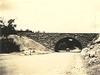 Grade Separation Structure Over US 21 Looking Northwest
1940
-
 Trail Shelter
1940
-
 Pedestrian Overlook at Fox Hunters Paradise
1940
-
 Construction of Combination Building, comfort station, picnic shelter, and refractory
1940
-
 Picnic Area #3 After Ice Storm
1940
-
 Equipment office showing oil house
1940
-
 Comfort Station Cumberland Knob
1940
-
 Bluff Park looking south
1940
-
 View of Parkway
1940
Items in Query
Results: 126
Refine Your Search
Types (1)
Photographs (126)Locations (42)
Doughton Park (21) Section 2N (9) Bluff Park (8) Cumberland Knob (8) Cumberland Knob Park (7) Big Laurel Gap (5) Bluffs (5) Milepost 238 (5) Milepost 168 (4) Milepost 237 (4) Bluff Park Maintenance Area (3) Milepost 217 (3) Milepost 224 (3) Milepost 241 (3) Milepost 348 (3) Milepost 140 (2) Milepost 153 (2) Milepost 199 (2) Milepost 229 (2) Milepost 231 (2) Milepost 347 (2) Milepost 359 (2) Section 2P (2) Bluffs Coffee Shop (1) Crabtree Meadows (1) Fishers Peak (1) Fox Hunters Paradise (1) Junction of 2A/2B (1) Milepost 155 (1) Milepost 185 (1) Milepost 221 (1) Milepost 225 (1) Milepost 239 (1) Milepost 240 (1) Milepost 247 (1) Milepost 248 (1) Milepost 349 (1) Milepost 350 (1) Mount Mitchell (1) Rocky Knob (Va.) (1) Section 2C (1) Section 2E (1)Sections (13)
2C (54) 2A (27) 2N (20) 1S (5) 2P (4) 1Q (3) 2M (3) 1P (2) 1V (2) 2B (2) 1U (1) 2D (1) 2E (1)Counties (10)
Alleghany (77) Yancey (11) Surry (7) Franklin (5) Buncombe (4) Floyd (4) Ashe (2) Carroll (2) McDowell (2) Patrick (2)

