
Driving Through Time - The Digital Blue Ridge Parkway

Search Results:
-
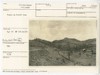
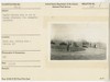
 View of table rock formation in valley to the east of parkway
October 22, 1936
-
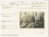
 Cumberland Knob Park Picnic Road
May 7, 1937
-
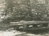 Picnic table
July 1, 1937
-
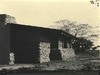 Back side of shelter
October 15, 1937
-
 Rocky Knob picnic road and parking area
January 5, 1938
-
 Picnic Table
March 12, 1938
-
 Picnic Table
March 12, 1938
-
 Saddle Parking Area in use on Sunday Afternoon
May 1, 1938
-
 Fence on R-O-W line
May 1938
-
 Saddle Parking Area in use on Sunday Afternoon
May 1, 1938
Items in Query
Results: 80
Refine Your Search
Types (4)
Photographs (48) Maps (18) Drawings, Plans, and Projections (8) Newspaper Articles (6)Locations (36)
Rocky Knob (Va.) (10) Cumberland Knob (9) Doughton Park (9) Smart View (V.A.) (6) Milepost 155 (3) Milepost 168 (2) Milepost 217 (2) Milepost 218 (2) Bass Lake (1) Bluff Park (1) Crabtree Meadows (1) Craggy Gardens (1) Craggy Knob (1) Grandfather Mountain (1) Mahogany Rock (1) Milepost 167 (1) Milepost 323 (1) Section 2A (1) Section 2B (1) Section 2C (1) Section 2D (1) Section 2E (1) Section 2F (1) Section 2G (1) Section 2H (1) Section 2J (1) Section 2K (1) Section 2L (1) Section 2M (1) Section 2N (1) Section 2P (1) Section 2Q (1) Section 2U (1) Section 2W (1) Sherando Lake Recreation Area (1) Soco Gap (1)Sections (21)
2A (14) 1S (13) 2C (11) 1Q (9) 2P (3) 2B (2) 2G (2) 2H (2) 2K (2) 2M (2) 1C (1) 2D (1) 2E (1) 2F (1) 2J (1) 2L (1) 2N (1) 2Q (1) 2U (1) 2W (1) 2Y (1)Counties (13)
Alleghany (27) Patrick (11) Franklin (9) Buncombe (4) McDowell (4) Avery (3) Watauga (3) Ashe (2) Floyd (2) Haywood (2) Yancey (2) Augusta (1) Transylvania (1)

